East Sierra, California
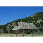
East Sierra: Barn...
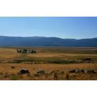
East Sierra: Ranch...
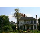
East Sierra: Victorian...
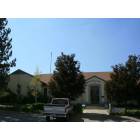
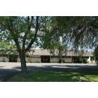
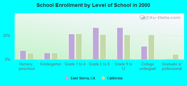
East Sierra: School..
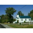
East Sierra: Church..
East Sierra: Motel...
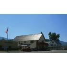
East Sierra: Cafe...

East Sierra: Library...
- add
your
Submit your own pictures of this place and show them to the world
- OSM Map
- General Map
- Google Map
- MSN Map

| Males: 1,153 | |
| Females: 1,167 |
| Median resident age: | 41.4 years |
| California median age: | 33.3 years |
Zip code: 96118
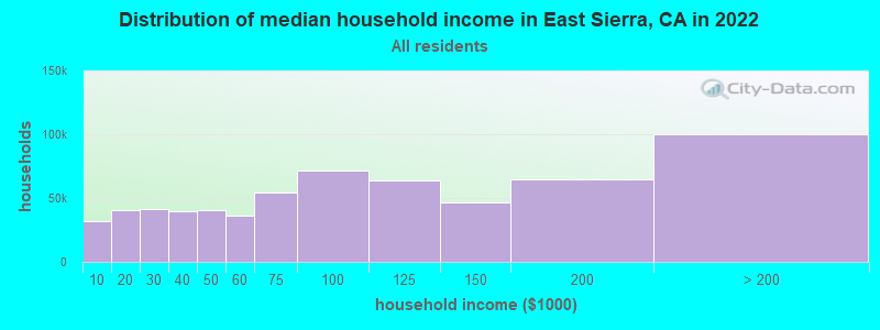
| East Sierra: | $59,304 |
| CA: | $91,551 |
Estimated per capita income in 2022: $36,981 (it was $18,037 in 2000)
East Sierra CCD income, earnings, and wages data
Estimated median house or condo value in 2022: $263,505 (it was $107,500 in 2000)
| East Sierra: | $263,505 |
| CA: | $715,900 |
Mean prices in 2022: all housing units: $370,184; detached houses: $389,061; mobile homes: $165,679
Detailed information about poverty and poor residents in East Sierra, CA


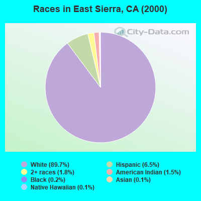
- 2,24489.7%White alone
- 1636.5%Hispanic
- 451.8%Two or more races
- 371.5%American Indian alone
- 60.2%Black alone
- 30.1%Asian alone
- 30.1%Native Hawaiian and Other
Pacific Islander alone
 Recent articles from our blog. Our writers, many of them Ph.D. graduates or candidates, create easy-to-read articles on a wide variety of topics.
Current Local Time: PST time zone
Land area: 509.8 square miles.
Population density: 4.6 people per square mile (very low).

| East Sierra CCD: | 0.8% ($863) |
| California: | 0.8% ($1,564) |
Nearest city with pop. 50,000+: Reno, NV  (27.4 miles , pop. 180,480).
Nearest city with pop. 200,000+: Sacramento, CA (95.2 miles , pop. 407,018).
Nearest city with pop. 1,000,000+: Los Angeles, CA (396.8 miles , pop. 3,694,820).
Nearest cities:
), ), )Latitude: 39.61 N, Longitude: 120.32 W
Area code commonly used in this area: 530

| Here: | 4.9% |
| California: | 5.1% |
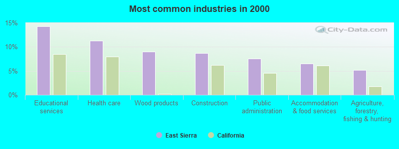
- Educational services (14.2%)
- Health care (11.3%)
- Wood products (9.0%)
- Construction (8.7%)
- Public administration (7.6%)
- Accommodation & food services (6.5%)
- Agriculture, forestry, fishing & hunting (5.2%)
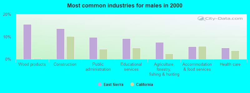
- Wood products (15.6%)
- Construction (13.6%)
- Public administration (9.7%)
- Educational services (9.2%)
- Agriculture, forestry, fishing & hunting (7.5%)
- Accommodation & food services (5.7%)
- Health care (5.1%)
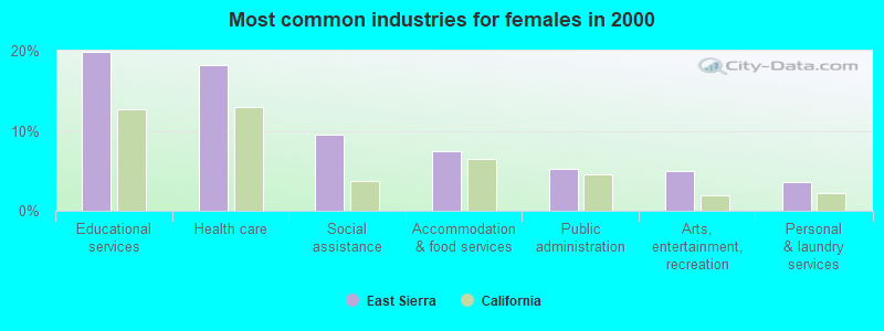
- Educational services (19.9%)
- Health care (18.3%)
- Social assistance (9.5%)
- Accommodation & food services (7.5%)
- Public administration (5.2%)
- Arts, entertainment, recreation (5.0%)
- Personal & laundry services (3.5%)
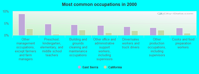
- Other management occupations, except farmers and farm managers (9.0%)
- Preschool, kindergarten, elementary, and middle school teachers (4.8%)
- Building and grounds cleaning and maintenance occupations (4.5%)
- Other office and administrative support workers, including supervisors (4.1%)
- Driver/sales workers and truck drivers (3.6%)
- Other production occupations, including supervisors (3.2%)
- Cooks and food preparation workers (3.1%)
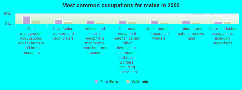
- Other management occupations, except farmers and farm managers (12.1%)
- Driver/sales workers and truck drivers (6.8%)
- Vehicle and mobile equipment mechanics, installers, and repairers (4.6%)
- Electrical equipment mechanics and other installation, maintenance, and repair workers, including supervisors (4.2%)
- Cooks and food preparation workers (4.2%)
- Laborers and material movers, hand (4.2%)
- Other production occupations, including supervisors (4.0%)
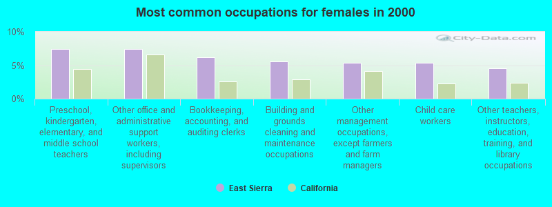
- Preschool, kindergarten, elementary, and middle school teachers (7.5%)
- Other office and administrative support workers, including supervisors (7.5%)
- Bookkeeping, accounting, and auditing clerks (6.2%)
- Building and grounds cleaning and maintenance occupations (5.6%)
- Other management occupations, except farmers and farm managers (5.4%)
- Child care workers (5.4%)
- Other teachers, instructors, education, training, and library occupations (4.6%)
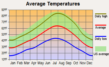
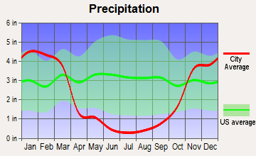
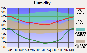
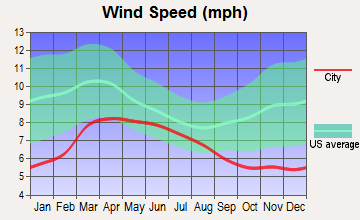
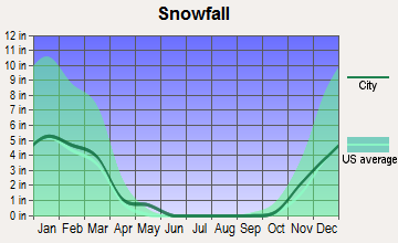
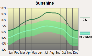
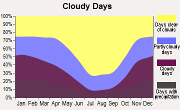
Average climate in East Sierra, California
Based on data reported by over 4,000 weather stations
(lower is better)
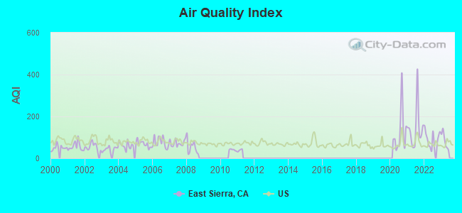
Air Quality Index (AQI) level in 2022 was 91.4. This is worse than average.
| City: | 91.4 |
| U.S.: | 72.6 |
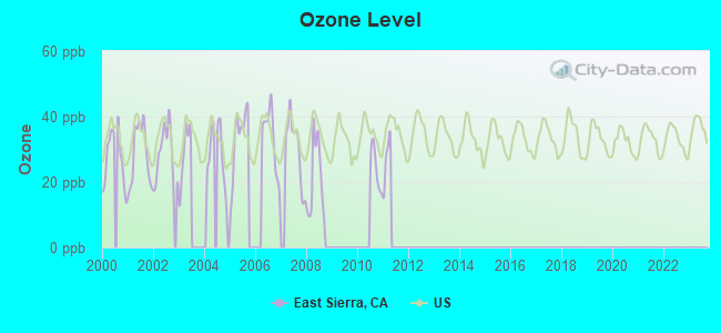
Ozone [ppb] level in 2008 was 21.1. This is significantly better than average. Closest monitor was 20.7 miles away from the city center.
| City: | 21.1 |
| U.S.: | 33.3 |
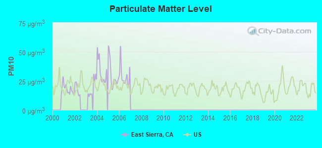
Particulate Matter (PM10) [µg/m3] level in 2006 was 29.3. This is significantly worse than average. Closest monitor was 6.4 miles away from the city center.
| City: | 29.3 |
| U.S.: | 19.2 |
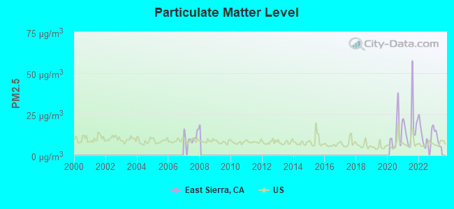
Particulate Matter (PM2.5) [µg/m3] level in 2022 was 12.3. This is significantly worse than average. Closest monitor was 15.0 miles away from the city center.
| City: | 12.3 |
| U.S.: | 8.1 |
Earthquake activity:
East Sierra-area historical earthquake activity is significantly above California state average. It is 6741% greater than the overall U.S. average.Natural disasters:
The number of natural disasters in Sierra County (13) is near the US average (15).Major Disasters (Presidential) Declared: 7
Emergencies Declared: 2
Causes of natural disasters: Floods: 9, Storms: 5, Winter Storms: 4, Landslides: 3, Mudslides: 3, Drought: 1, Fire: 1, Heavy Rain: 1, Hurricane: 1, Other: 1 (Note: some incidents may be assigned to more than one category).
Colleges/universities with over 2000 students nearest to East Sierra:
- University of Nevada-Reno (about 28 miles; Reno, NV; Full-time enrollment: 15,092)
- Truckee Meadows Community College (about 29 miles; Reno, NV; FT enrollment: 6,919)
- Western Nevada College (about 41 miles; Carson City, NV; FT enrollment: 2,338)
- Butte College (about 71 miles; Oroville, CA; FT enrollment: 8,649)
- Yuba College (about 74 miles; Marysville, CA; FT enrollment: 4,737)
- Sierra College (about 74 miles; Rocklin, CA; FT enrollment: 11,488)
- Folsom Lake College (about 79 miles; Folsom, CA; FT enrollment: 5,308)
Points of interest:
Notable locations in East Sierra: Canyon Ranch (A), Cold Creek Campground (B), Wheelers Sheep Camp (C), Yuba-Sutter Camp (D), Winnie Smith Mill (E), East Meadow Campground (F), Franklin Cabin (G), Clio Forest Service Facility (H), Purdy (I), Old Fish Farm (J), Stampede Campground (K), Nichols Mill (L), Cottonwood Campground (M), East Meadow Campground (N), Males Station Campground (O), Pass Creek Campground (P), Lewis Mill Station (Q), Jackson Point Campground (R), Balls Ranch (S), Campbell Sheep Camp (T). Display/hide their locations on the map
Cemetery: Sierraville Cemetery (1). Display/hide its location on the map
Lakes and reservoirs: Lake of The Woods (A), Webber Lake (B), Coburn Lake (C), Calpine Reservoir (D), Stampede Reservoir (E), Palen Reservoir (F). Display/hide their locations on the map
Creeks: Cottonwood Creek (A), Hamlin Creek (B), Independence Creek (C), Fletcher Creek (D), Little Boulder Creek (E), North Branch Dog Creek (F), Perry Creek (G), Davies Creek (H), Sardine Creek (I). Display/hide their locations on the map
Parks in East Sierra include: Calpine Park (1), Loyalton Park (2), Babbit Peak Research Natural Area (3). Display/hide their locations on the map
| This place: | 2.3 people |
| California: | 2.9 people |
| This place: | 65.2% |
| Whole state: | 68.7% |
| This place: | 7.2% |
| Whole state: | 7.2% |
Likely homosexual households (counted as self-reported same-sex unmarried-partner households)
- Lesbian couples: 0.2% of all households
- Gay men: 0.1% of all households
| This place: | 12.4% |
| Whole state: | 14.2% |
| This place: | 5.5% |
| Whole state: | 6.3% |
People in group quarters in East Sierra in 2000:
- 30 people in nursing homes
- 4 people in local jails and other confinement facilities (including police lockups)
- 2 people in other nonhousehold living situations
For population 15 years and over in East Sierra:
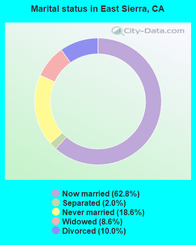
- Never married: 18.6%
- Now married: 62.8%
- Separated: 2.0%
- Widowed: 8.6%
- Divorced: 10.0%
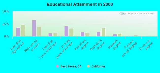
For population 25 years and over in East Sierra:
- High school or higher: 82.7%
- Bachelor's degree or higher: 14.9%
- Graduate or professional degree: 5.9%
- Unemployed: 9.6%
- Mean travel time to work (commute): 26.2 minutes
| Here: | 10.5 |
| California average: | 16.1 |
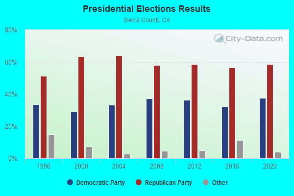


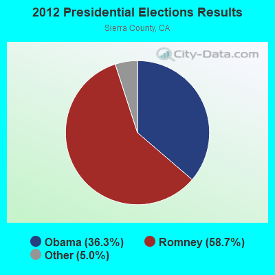
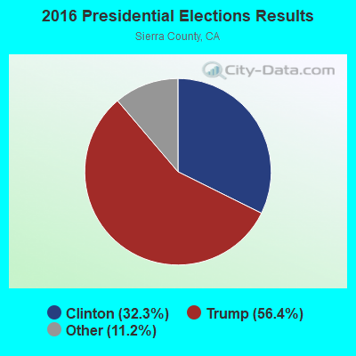

Graphs represent county-level data. Detailed 2008 Election Results
Religion statistics for East Sierra, CA (based on Sierra County data)
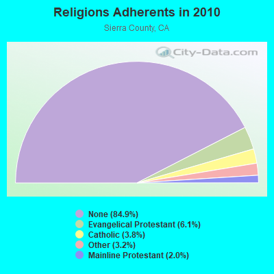
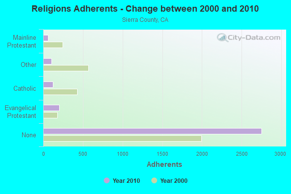
| Religion | Adherents | Congregations |
|---|---|---|
| Evangelical Protestant | 199 | 4 |
| Catholic | 122 | 2 |
| Other | 104 | 1 |
| Mainline Protestant | 64 | 2 |
| None | 2,751 | - |
Food Environment Statistics:
| This county: | 6.04 / 10,000 pop. |
| State: | 2.14 / 10,000 pop. |
| Sierra County: | 9.06 / 10,000 pop. |
| California: | 1.49 / 10,000 pop. |
| Here: | 12.08 / 10,000 pop. |
| California: | 7.42 / 10,000 pop. |
| This county: | 8.6% |
| California: | 7.3% |
| Here: | 24.0% |
| California: | 21.3% |
Strongest AM radio stations in East Sierra:
- KKOH (780 AM; 50 kW; RENO, NV; Owner: CITADEL BROADCASTING COMPANY)
- KPTT (630 AM; 5 kW; RENO, NV; Owner: LOTUS RADIO CORP.)
- KBZZ (1270 AM; 13 kW; SPARKS, NV; Owner: AMERICOM LAS VEGAS LIMITED PARTNERSHIP)
- KFIA (710 AM; 25 kW; CARMICHAEL, CA; Owner: VISTA BROADCASTING INC.)
- KFBK (1530 AM; 50 kW; SACRAMENTO, CA; Owner: AMFM RADIO LICENSES, L.L.C.)
- KHTK (1140 AM; 50 kW; SACRAMENTO, CA; Owner: INFINITY RADIO SUBSIDIARY OPERATIONS INC.)
- KIHM (920 AM; 5 kW; RENO, NV; Owner: IHR EDUCATIONAL BROADCASTING)
- KSTE (650 AM; 25 kW; RANCHO CORDOVA, CA; Owner: AMFM RADIO LICENSES, L.L.C.)
- KCBC (770 AM; 50 kW; RIVERBANK, CA; Owner: KIERTRON, INC.)
- KNCO (830 AM; 5 kW; GRASS VALLEY, CA; Owner: NEVADA COUNTY BROADCASTERS, INC.)
- KCBS (740 AM; 50 kW; SAN FRANCISCO, CA; Owner: INFINITY BROADCASTING OPERATIONS, INC.)
- KQLO (1590 AM; 5 kW; SUN VALLEY, NV; Owner: THOMAS AQUINAS SCHOOL)
- KXTO (1550 AM; 2 kW; RENO, NV; Owner: FIRST BROADCASTING OF NEVADA, INC.)
Strongest FM radio stations in East Sierra:
- K285EQ (104.9 FM; VERDI, NV; Owner: AMERICOM, A CALIFORNIA LIMITED PARTNERSHIP)
- KRNO (106.9 FM; INCLINE VILLAGE, NV; Owner: AMERICOM LAS VEGAS LIMITED PARTNERSHIP)
- KODS (103.7 FM; CARNELIAN BAY, CA; Owner: AMERICOM, A CALIFORNIA LIMITED PARTNERSHIP)
- KLCA (96.5 FM; TAHOE CITY, CA; Owner: AMERICOM LAS VEGAS LIMITED PARTNERSHIP)
- KDOT (104.5 FM; RENO, NV; Owner: LOTUS RADIO CORP.)
- KOZZ-FM (105.7 FM; RENO, NV; Owner: LOTUS RADIO CORP.)
- KKTO (90.5 FM; TAHOE CITY, CA; Owner: CALIFORNIA STATE UNIVERSITY)
- KSRN (107.7 FM; KINGS BEACH, CA; Owner: NM LICENSING, LLC)
- KTHX-FM (100.1 FM; DAYTON, NV; Owner: NM LICENSING, LLC)
- KTKE (101.5 FM; TRUCKEE, CA; Owner: TRUCKSTER BROADCASTING, INC.)
- KHXR (94.5 FM; SUN VALLEY, NV; Owner: LOTUS RADIO CORP.)
- KHGQ (100.3 FM; QUINCY, CA; Owner: KEILY MILLER)
- KNHK (92.9 FM; RENO, NV; Owner: CITADEL BROADCASTING COMPANY)
- KBUL-FM (98.1 FM; CARSON CITY, NV; Owner: CITADEL BROADCASTING COMPANY)
- KNEV (95.5 FM; RENO, NV; Owner: CITADEL BROADCASTING COMPANY)
- KNIS (91.3 FM; CARSON CITY, NV; Owner: WESTERN INSPIRATIONAL BROADCASTERS, INC)
- KWYL (102.9 FM; SOUTH LAKE TAHOE, CA; Owner: CITADEL BROADCASTING COMPANY)
- KUNR (88.7 FM; RENO, NV; Owner: UNIVERSITY OF NEVADA, RENO)
- KWNZ (97.3 FM; CARSON CITY, NV; Owner: AMERICOM LAS VEGAS LIMITED PARTNERSHIP)
- KSSJ (94.7 FM; FAIR OAKS, CA; Owner: ENTERCOM SACRAMENTO LICENSE, LLC)
TV broadcast stations around East Sierra:
- K11SW (Channel 11; SIERRAVILLE, CA; Owner: SIERRAVILLE T.V. ASSOCIATION)
- 47.5%Wood
- 28.4%Bottled, tank, or LP gas
- 14.4%Fuel oil, kerosene, etc.
- 5.1%Electricity
- 3.1%Other fuel
- 1.5%Utility gas
- 30.2%Bottled, tank, or LP gas
- 28.0%Wood
- 26.7%Electricity
- 11.9%Fuel oil, kerosene, etc.
- 1.9%Other fuel
- 1.3%Utility gas
East Sierra compared to California state average:
- Median household income below state average.
- Median house value significantly below state average.
- Black race population percentage significantly below state average.
- Hispanic race population percentage significantly below state average.
- Median age significantly above state average.
- Foreign-born population percentage significantly below state average.
- Renting percentage below state average.
- Length of stay since moving in significantly above state average.
- Number of rooms per house significantly below state average.
- House age significantly below state average.
- Number of college students below state average.
- Percentage of population with a bachelor's degree or higher below state average.