East Roosevelt, Montana
Submit your own pictures of this place and show them to the world
- OSM Map
- General Map
- Google Map
- MSN Map

| Males: 762 | |
| Females: 743 |
| Median resident age: | 43.7 years |
| Montana median age: | 37.5 years |
Zip code: 59218
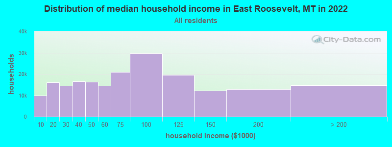
| East Roosevelt: | $59,070 |
| MT: | $67,631 |
Estimated per capita income in 2022: $28,645 (it was $15,603 in 2000)
East Roosevelt CCD income, earnings, and wages data
Estimated median house or condo value in 2022: $111,623 (it was $39,300 in 2000)
| East Roosevelt: | $111,623 |
| MT: | $366,400 |
East Roosevelt, MT residents, houses, and apartments details
Detailed information about poverty and poor residents in East Roosevelt, MT
Compare current foreclosures near East Roosevelt, MT:
| Photo | Address | Area | Beds / Baths | Price | Details |
|---|---|---|---|---|---|

|
#1
W 3rd St
Culbertson, MT 59218
|
1,680 sq. feet
|
2 baths 3 beds |
show details | |

|
#2
Clark
Bainville, MT 59212
|
1,992 sq. feet
|
1 baths 3 beds |
show details | |

|
Check over 1 million property listings on Foreclosure.com!
|
browse all offers | |||

- 1,43991.2%White alone
- 684.3%American Indian alone
- 473.0%Two or more races
- 161.0%Hispanic
- 40.3%Other race alone
- 20.1%Black alone
- 20.1%Asian alone

Races in East Roosevelt detailed stats: ancestries, foreign born residents, place of birth
 Recent articles from our blog. Our writers, many of them Ph.D. graduates or candidates, create easy-to-read articles on a wide variety of topics.
Current Local Time: MST time zone
Land area: 608.8 square miles.
Population density: 2.5 people per square mile (very low).

| East Roosevelt CCD: | 1.3% ($518) |
| Montana: | 1.3% ($1,212) |
Nearest city with pop. 50,000+: Bismarck, ND  (195.2 miles , pop. 55,532).
Nearest city with pop. 200,000+: Minneapolis, MN (574.4 miles , pop. 382,618).
Nearest city with pop. 1,000,000+: Chicago, IL (926.2 miles , pop. 2,896,016).
Nearest cities:
), ), ), Latitude: 48.22 N, Longitude: 104.40 W
Area code commonly used in this area: 406

| Here: | 4.9% |
| Montana: | 3.8% |

- Agriculture, forestry, fishing & hunting (19.2%)
- Educational services (15.9%)
- Health care (12.5%)
- Construction (7.2%)
- Accommodation & food services (4.9%)
- Public administration (4.6%)
- Truck transportation (3.5%)

- Agriculture, forestry, fishing & hunting (30.4%)
- Construction (12.2%)
- Educational services (12.2%)
- Truck transportation (6.4%)
- Public administration (5.1%)
- Food (4.1%)
- Accommodation & food services (3.8%)

- Health care (24.5%)
- Educational services (20.2%)
- Accommodation & food services (6.1%)
- Agriculture, forestry, fishing & hunting (5.8%)
- Finance & insurance (4.3%)
- Public administration (4.0%)
- Food & beverage stores (4.0%)

- Farmers and farm managers (14.9%)
- Preschool, kindergarten, elementary, and middle school teachers (7.0%)
- Building and grounds cleaning and maintenance occupations (4.5%)
- Driver/sales workers and truck drivers (4.5%)
- Other office and administrative support workers, including supervisors (4.3%)
- Agricultural workers, including supervisors (3.8%)
- Cooks and food preparation workers (3.6%)

- Farmers and farm managers (24.0%)
- Driver/sales workers and truck drivers (8.2%)
- Agricultural workers, including supervisors (5.9%)
- Carpenters (5.4%)
- Vehicle and mobile equipment mechanics, installers, and repairers (5.1%)
- Building and grounds cleaning and maintenance occupations (4.6%)
- Preschool, kindergarten, elementary, and middle school teachers (4.3%)

- Preschool, kindergarten, elementary, and middle school teachers (10.1%)
- Other office and administrative support workers, including supervisors (8.3%)
- Nursing, psychiatric, and home health aides (6.4%)
- Secretaries and administrative assistants (5.8%)
- Cooks and food preparation workers (5.5%)
- Health technologists and technicians (4.3%)
- Building and grounds cleaning and maintenance occupations (4.3%)
Average climate in East Roosevelt, Montana
Based on data reported by over 4,000 weather stations


Earthquake activity:
East Roosevelt-area historical earthquake activity is above Montana state average. It is 159% greater than the overall U.S. average.On 8/18/1959 at 06:37:13, a magnitude 7.7 (7.7 UK, Class: Major, Intensity: VIII - XII) earthquake occurred 390.9 miles away from the city center, causing $26,000,000 total damage
On 10/28/1983 at 14:06:06, a magnitude 7.3 (6.2 MB, 7.3 MS, 7.0 MW) earthquake occurred 533.5 miles away from the city center, causing 2 deaths (2 shaking deaths) and 3 injuries, causing $15,000,000 total damage
On 6/30/1975 at 18:54:13, a magnitude 6.1 (5.6 MB, 5.9 MS, 6.1 UK, 6.1 ML, Class: Strong, Intensity: VII - IX) earthquake occurred 389.0 miles away from the city center
On 7/6/2017 at 06:30:17, a magnitude 5.8 (5.8 MW, Depth: 7.6 mi, Class: Moderate, Intensity: VI - VII) earthquake occurred 392.5 miles away from the city center
On 7/29/1998 at 03:31:58, a magnitude 3.8 (3.8 MB, 3.7 LG, 3.4 LG, Depth: 3.1 mi, Class: Light, Intensity: II - III) earthquake occurred 17.4 miles away from East Roosevelt center
On 2/25/2014 at 22:45:38, a magnitude 3.8 (3.8 MB, Depth: 3.1 mi) earthquake occurred 23.9 miles away from the city center
Magnitude types: regional Lg-wave magnitude (LG), body-wave magnitude (MB), local magnitude (ML), surface-wave magnitude (MS), moment magnitude (MW)
Natural disasters:
The number of natural disasters in Roosevelt County (5) is a lot smaller than the US average (15).Major Disasters (Presidential) Declared: 3
Emergencies Declared: 1
Causes of natural disasters: Floods: 2, Storms: 2, Hurricane: 1, Snow: 1, Winter Storm: 1, Other: 1 (Note: some incidents may be assigned to more than one category).
Colleges/universities with over 2000 students nearest to East Roosevelt:
- Minot State University (about 143 miles; Minot, ND; Full-time enrollment: 2,887)
- Bismarck State College (about 194 miles; Bismarck, ND; FT enrollment: 3,015)
- University of Mary (about 200 miles; Bismarck, ND; FT enrollment: 2,854)
- Montana State University-Billings (about 257 miles; Billings, MT; FT enrollment: 4,319)
- Black Hills State University (about 260 miles; Spearfish, SD; FT enrollment: 3,166)
- Sheridan College (about 269 miles; Sheridan, WY; FT enrollment: 2,070)
- South Dakota School of Mines and Technology (about 293 miles; Rapid City, SD; FT enrollment: 2,102)
Points of interest:
Notable locations in East Roosevelt: Farmers Elevator Company Elevator (A), Farmers Elevator Company of Froid - Elevator Number One (B), Bainville Rest Area (C), Froid Elevator Company of Froid - Elevator Number Two (D), Custom Built Feeds Elevator (E), McCabe (F), Lakeside (G), Froid (H), Culbertson (I), Bainville (J), Roosevelt County Sheriff's Department Substation (K), Culbertson Police Department (L), Culbertson Volunteer Fire Department (M), Culbertson Museum (N), Froid Volunteer Fire Department (O), Froid Public Library (P), Culbertson Public Library (Q), Bainville Public Library (R), Bainville Rural Fire District (S). Display/hide their locations on the map
Churches in East Roosevelt include: Ebenezer Church (A), Reorganized Church of Jesus Christ of Latter Day Saints (B), Everson-Clayton Mortuary Chapel (C), Bethel Free Lutheran Church (D), Trinity Lutheran Church (E), Saint Anthonys Catholic Church (F), First Baptist Church (G), Freidens Church (H), Froid Lutheran Church (I). Display/hide their locations on the map
Cemeteries: Mondak Cemetery (1), Freidens Cemetery (2), South Cemetery (3), Kvile Cemetery (4), Bainville Cemetery (5), Bauer Cemetery (6), Hillside Cemetery (7). Display/hide their locations on the map
Lakes and reservoirs: Johnson Lake (A), Duck Lake (B), Homestead Lake (C), Harmon Reservoir (D), Picard Reservoir (E), Shotgun Reservoir (F). Display/hide their locations on the map
Creeks: Cedar Creek (A), Deer Creek (B), Horse Tied Creek (C), Little Muddy Creek (D), Lost Creek (E), Red Bank Creek (F), Sand Creek (G), Sheep Creek (H), Shotgun Creek (I). Display/hide their locations on the map
Parks in East Roosevelt include: Fjeseth Field (1), Bruegger Centennial Park (2), Swimming Pool Park (3), C C Recreation Complex (4), Town Park (5), Snowden Bridge Historical Marker (6), Fort Union Historical Marker (7). Display/hide their locations on the map
| This place: | 2.3 people |
| Montana: | 2.4 people |
| This place: | 63.6% |
| Whole state: | 62.8% |
| This place: | 3.7% |
| Whole state: | 6.7% |
Likely homosexual households (counted as self-reported same-sex unmarried-partner households)
- Lesbian couples: 0.3% of all households
- Gay men: 0.0% of all households
| This place: | 10.8% |
| Whole state: | 14.6% |
| This place: | 3.5% |
| Whole state: | 5.8% |
32 people in wards in general hospitals for patients who have no usual home elsewhere in 2000
For population 15 years and over in East Roosevelt:

- Never married: 19.9%
- Now married: 62.6%
- Separated: 0.4%
- Widowed: 11.4%
- Divorced: 6.1%
For population 25 years and over in East Roosevelt:
- High school or higher: 82.3%
- Bachelor's degree or higher: 18.2%
- Graduate or professional degree: 3.6%
- Unemployed: 3.1%
- Mean travel time to work (commute): 13.0 minutes


| Here: | 11.3 |
| Montana average: | 10.4 |
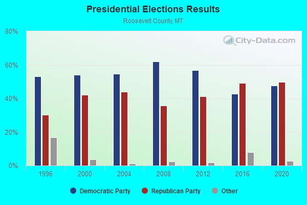
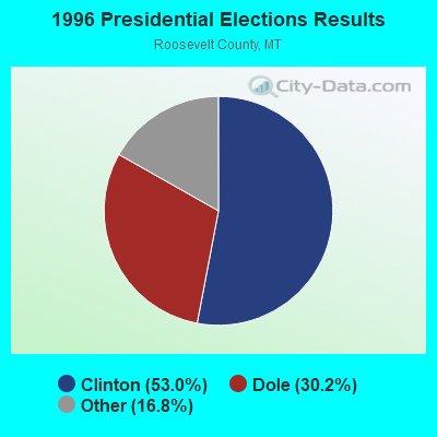
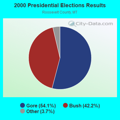
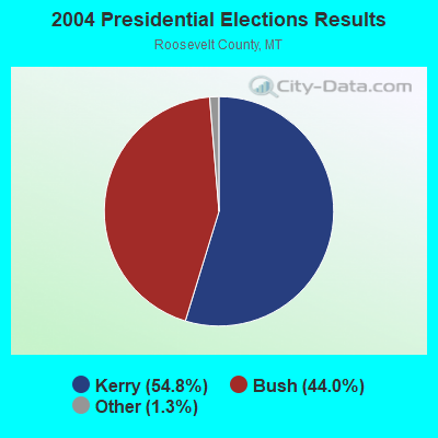
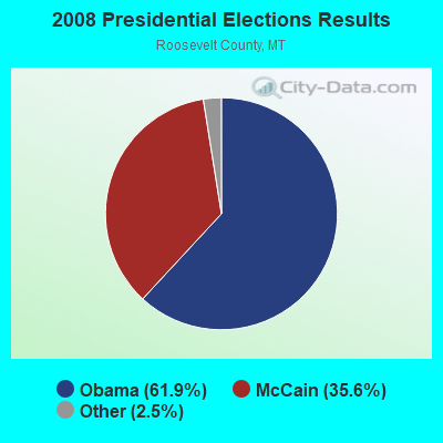
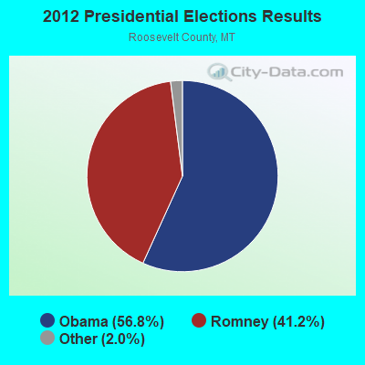
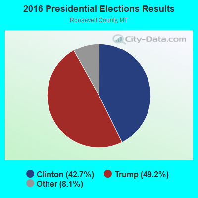
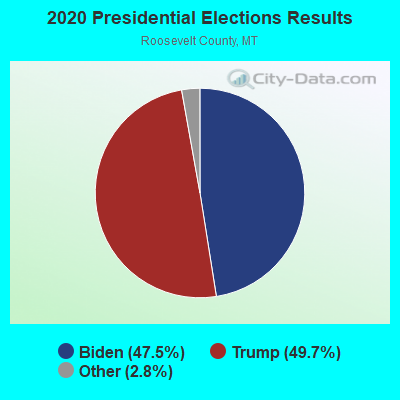
Graphs represent county-level data. Detailed 2008 Election Results
Religion statistics for East Roosevelt, MT (based on Roosevelt County data)
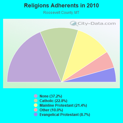
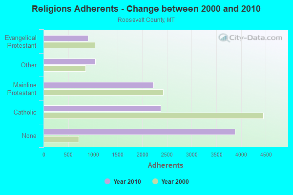
| Religion | Adherents | Congregations |
|---|---|---|
| Catholic | 2,375 | 5 |
| Mainline Protestant | 2,228 | 16 |
| Other | 1,046 | 3 |
| Evangelical Protestant | 902 | 21 |
| None | 3,874 | - |
Food Environment Statistics:
| This county: | 5.92 / 10,000 pop. |
| Montana: | 2.55 / 10,000 pop. |
| Here: | 8.88 / 10,000 pop. |
| Montana: | 4.69 / 10,000 pop. |
| Roosevelt County: | 7.89 / 10,000 pop. |
| Montana: | 10.38 / 10,000 pop. |
| Roosevelt County: | 12.3% |
| Montana: | 7.2% |
| Here: | 29.9% |
| Montana: | 23.1% |
| Roosevelt County: | 20.6% |
| Montana: | 10.7% |
Strongest AM radio stations in East Roosevelt:
- KEYZ (660 AM; 5 kW; WILLISTON, ND; Owner: COMMONWEALTH LICENSE SUBSIDIARY, LLC)
- KATQ (1070 AM; daytime; 5 kW; PLENTYWOOD, MT; Owner: RADIO INTERNAT'L-KATQ B/CAST ASSOC.)
- KXMR (710 AM; 50 kW; BISMARCK, ND; Owner: RADIO BISMARCK MANDAN, LLC)
- KATL (770 AM; 10 kW; MILES CITY, MT; Owner: STAR PRINTING COMPANY)
- KMTA (1050 AM; 10 kW; MILES CITY, MT; Owner: SENGER BROADCASTING CORPORATION)
- KBHB (810 AM; 25 kW; STURGIS, SD; Owner: MONTEREY LICENSES, LLC)
- WWNL (1080 AM; 50 kW; PITTSBURGH, PA; Owner: STEEL CITY RADIO, INC.)
- KHRT (1320 AM; 10 kW; MINOT, ND; Owner: FAITH BROADCASTING, INC.)
- KTWO (1030 AM; 50 kW; CASPER, WY; Owner: CITICASTERS LICENSES, L.P.)
- KFLN (960 AM; 5 kW; BAKER, MT; Owner: NEWELL BROADCASTING INC.)
- KERR (750 AM; 50 kW; POLSON, MT; Owner: ANDERSON RADIO BROADCASTING, INC.)
- KCJB (910 AM; 5 kW; MINOT, ND; Owner: CLEAR CHANNEL BROADCASTING LICENSES, INC.)
- KGLE (590 AM; 1 kW; GLENDIVE, MT; Owner: FRIENDS OF CHRISTIAN RADIO, INC.)
Strongest FM radio stations in East Roosevelt:
- K201FG (88.1 FM; CULBERTSON, MT; Owner: CALVARY CHAPEL OF TWIN FALLS, INC.)
- KTHC (95.1 FM; SIDNEY, MT; Owner: COMMONWEALTH LICENSE SUBSIDIARY, LLC)
- KYYZ (96.1 FM; WILLISTON, ND; Owner: COMMONWEALTH LICENSE SUBSIDIARY, LLC)
- KDSR (101.1 FM; WILLISTON, ND; Owner: WILLISTON COMMUNITY BROADCASTING CORP. D/B/A KDSR(FM))
- KPPR (89.5 FM; WILLISTON, ND; Owner: PRAIRIE PUBLIC B/CNG, INC.)
TV broadcast stations around East Roosevelt:
- KXMD-TV (Channel 11; WILLISTON, ND; Owner: REITEN TELEVISION, INC.)
- KWSE (Channel 4; WILLISTON, ND; Owner: PRAIRIE PUBLIC BROADCASTING, INC.)
- K34GY (Channel 34; CULBERTSON, MT; Owner: TOWN OF CULBERTSON)
- KUMV-TV (Channel 8; WILLISTON, ND; Owner: NORTH DAKOTA TELEVISION LICENSE SUB, L.L.C.)
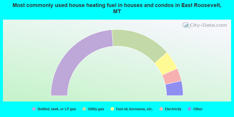
- 47.5%Bottled, tank, or LP gas
- 29.8%Utility gas
- 9.2%Fuel oil, kerosene, etc.
- 6.3%Electricity
- 3.8%Wood
- 1.8%Other fuel
- 1.6%Coal or coke
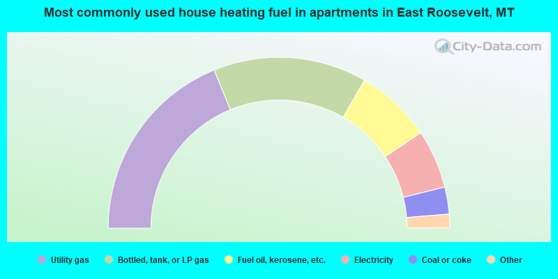
- 37.6%Utility gas
- 29.1%Bottled, tank, or LP gas
- 14.5%Fuel oil, kerosene, etc.
- 11.1%Electricity
- 5.1%Coal or coke
- 1.7%Wood
- 0.9%Other fuel
East Roosevelt compared to Montana state average:
- Median house value significantly below state average.
- Unemployed percentage significantly below state average.
- Black race population percentage below state average.
- Hispanic race population percentage significantly below state average.
- Median age above state average.
- Foreign-born population percentage significantly below state average.
- Length of stay since moving in significantly above state average.
- Number of rooms per house significantly below state average.
- House age significantly below state average.
- Number of college students below state average.
East Roosevelt on our top lists:
- #19 on the list of "Top 101 cities with the largest percentage of people in wards in general hospitals for patients who have no usual home elsewhere (population 1,000+)"
- #66 on the list of "Top 101 counties with the lowest surface withdrawal of fresh water for public supply"