East Roger Mills, Oklahoma
Submit your own pictures of this place and show them to the world
- OSM Map
- General Map
- Google Map
- MSN Map

| Males: 469 | |
| Females: 452 |
| Median resident age: | 37.6 years |
| Oklahoma median age: | 35.5 years |
Zip code: 73650
| East Roger Mills: | $58,834 |
| OK: | $59,673 |
Estimated per capita income in 2022: $37,566 (it was $14,800 in 2000)
East Roger Mills CCD income, earnings, and wages data
Estimated median house or condo value in 2022: $156,001 (it was $47,600 in 2000)
| East Roger Mills: | $156,001 |
| OK: | $191,700 |
Mean prices in 2022: all housing units: $208,782; detached houses: $230,483; mobile homes: $119,621
East Roger Mills, OK residents, houses, and apartments details
Detailed information about poverty and poor residents in East Roger Mills, OK
Compare current foreclosures near East Roger Mills, OK:
| Photo | Address | Area | Beds / Baths | Price | Details |
|---|---|---|---|---|---|

|
#1
N Lacy Ave
Butler, OK 73625
|
2,072 sq. feet
|
2 baths 4 beds |
show details | |

|
#2
S 11th St
Hammon, OK 73650
|
- sq. feet
|
- baths - beds |
show details | |

|
#3
E 900 Rd
Hammon, OK 73650
|
- sq. feet
|
- baths - beds |
show details | |

|
#4
N 2030 Rd
Leedey, OK 73654
|
- sq. feet
|
- baths - beds |
show details | |

|
#5
N 2131 Pl
Foss, OK 73647
|
- sq. feet
|
- baths - beds |
show details | |

|
#6
N 2132 Rd
Foss, OK 73647
|
- sq. feet
|
- baths - beds |
show details | |

|
Check over 1 million property listings on Foreclosure.com!
|
browse all offers | |||

- 74977.7%White alone
- 15716.3%American Indian alone
- 414.3%Hispanic
- 131.3%Two or more races
- 30.3%Black alone
- 10.1%Asian alone

Races in East Roger Mills detailed stats: ancestries, foreign born residents, place of birth
 Recent articles from our blog. Our writers, many of them Ph.D. graduates or candidates, create easy-to-read articles on a wide variety of topics.
Current Local Time: CST time zone
Land area: 332.1 square miles.
Population density: 2.8 people per square mile (very low).

| East Roger Mills CCD: | 0.4% ($199) |
| Oklahoma: | 0.8% ($523) |
Nearest city with pop. 50,000+: Lawton, OK  (94.5 miles , pop. 92,757).
Nearest city with pop. 200,000+: Oklahoma City, OK (108.4 miles , pop. 506,132).
Nearest city with pop. 1,000,000+: Dallas, TX (250.9 miles , pop. 1,188,580).
Nearest cities:
), ), Latitude: 35.69 N, Longitude: 99.45 W
Area code commonly used in this area: 580


| Here: | 2.3% |
| Oklahoma: | 3.2% |
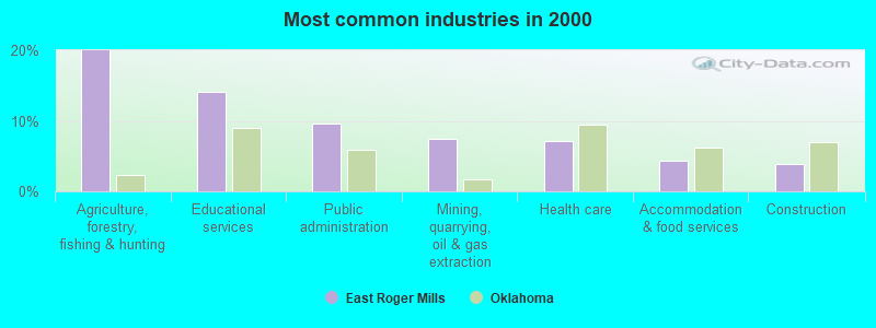
- Agriculture, forestry, fishing & hunting (20.0%)
- Educational services (14.1%)
- Public administration (9.6%)
- Mining, quarrying, oil & gas extraction (7.4%)
- Health care (7.2%)
- Accommodation & food services (4.3%)
- Construction (3.9%)
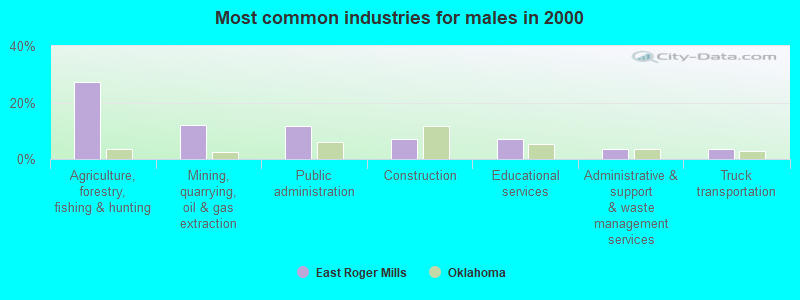
- Agriculture, forestry, fishing & hunting (27.3%)
- Mining, quarrying, oil & gas extraction (11.9%)
- Public administration (11.5%)
- Construction (6.9%)
- Educational services (6.9%)
- Administrative & support & waste management services (3.5%)
- Truck transportation (3.5%)
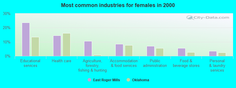
- Educational services (23.5%)
- Health care (14.5%)
- Agriculture, forestry, fishing & hunting (10.5%)
- Accommodation & food services (8.5%)
- Public administration (7.0%)
- Food & beverage stores (5.5%)
- Personal & laundry services (3.5%)

- Farmers and farm managers (15.2%)
- Agricultural workers, including supervisors (4.8%)
- Preschool, kindergarten, elementary, and middle school teachers (4.6%)
- Driver/sales workers and truck drivers (4.6%)
- Other sales and related occupations, including supervisors (4.1%)
- Cooks and food preparation workers (4.1%)
- Cashiers (3.7%)

- Farmers and farm managers (20.8%)
- Driver/sales workers and truck drivers (8.1%)
- Vehicle and mobile equipment mechanics, installers, and repairers (6.5%)
- Agricultural workers, including supervisors (6.5%)
- Law enforcement workers, including supervisors (5.4%)
- Building and grounds cleaning and maintenance occupations (5.0%)
- Other sales and related occupations, including supervisors (4.6%)

- Preschool, kindergarten, elementary, and middle school teachers (8.5%)
- Cooks and food preparation workers (8.5%)
- Secretaries and administrative assistants (8.0%)
- Farmers and farm managers (8.0%)
- Cashiers (7.5%)
- Nursing, psychiatric, and home health aides (5.0%)
- Bookkeeping, accounting, and auditing clerks (4.0%)
Average climate in East Roger Mills, Oklahoma
Based on data reported by over 4,000 weather stations


Tornado activity:
East Roger Mills-area historical tornado activity is slightly below Oklahoma state average. It is 104% greater than the overall U.S. average.
On 6/10/1967, a category F4 (max. wind speeds 207-260 mph) tornado 7.0 miles away from the East Roger Mills place center killed 4 people and injured one person and caused between $50,000 and $500,000 in damages.
On 5/25/1955, a category F4 tornado 24.7 miles away from the place center killed 2 people and injured 18 people and caused between $50,000 and $500,000 in damages.
Earthquake activity:
East Roger Mills-area historical earthquake activity is significantly above Oklahoma state average. It is 771% greater than the overall U.S. average.On 9/3/2016 at 12:02:44, a magnitude 5.8 (5.8 MW, Depth: 3.5 mi, Class: Moderate, Intensity: VI - VII) earthquake occurred 149.7 miles away from East Roger Mills center
On 11/6/2011 at 03:53:10, a magnitude 5.7 (5.7 MW, Depth: 3.2 mi) earthquake occurred 151.1 miles away from East Roger Mills center
On 2/13/2016 at 17:07:06, a magnitude 5.1 (5.1 MW, Depth: 5.2 mi) earthquake occurred 69.2 miles away from East Roger Mills center
On 1/7/2016 at 04:27:57, a magnitude 4.7 (4.7 MW, Depth: 2.5 mi, Class: Light, Intensity: IV - V) earthquake occurred 69.0 miles away from the city center
On 6/16/1978 at 11:46:54, a magnitude 5.3 (4.4 MB, 4.6 UK, 5.3 ML) earthquake occurred 198.6 miles away from the city center
On 11/7/2016 at 01:44:24, a magnitude 5.0 (5.0 MW, Depth: 2.8 mi) earthquake occurred 149.7 miles away from East Roger Mills center
Magnitude types: body-wave magnitude (MB), local magnitude (ML), moment magnitude (MW)
Natural disasters:
The number of natural disasters in Roger Mills County (25) is a lot greater than the US average (15).Major Disasters (Presidential) Declared: 16
Emergencies Declared: 5
Causes of natural disasters: Winter Storms: 12, Floods: 9, Storms: 8, Tornadoes: 6, Ice Storms: 2, Winds: 2, Fire: 1, Hurricane: 1, Snowstorm: 1, Other: 1 (Note: some incidents may be assigned to more than one category).
Colleges/universities with over 2000 students nearest to East Roger Mills:
- Southwestern Oklahoma State University (about 43 miles; Weatherford, OK; Full-time enrollment: 4,126)
- Western Oklahoma State College (about 71 miles; Altus, OK; FT enrollment: 2,054)
- Cameron University (about 95 miles; Lawton, OK; FT enrollment: 4,695)
- Southern Nazarene University (about 103 miles; Bethany, OK; FT enrollment: 2,064)
- Oklahoma State University-Oklahoma City (about 106 miles; Oklahoma City, OK; FT enrollment: 4,784)
- Vernon College (about 106 miles; Vernon, TX; FT enrollment: 2,216)
- Oklahoma City Community College (about 108 miles; Oklahoma City, OK; FT enrollment: 8,904)
Points of interest:
Notable locations in East Roger Mills: Angora (A), Roger Mills County Ambulance Service Hammon (B), Hammon Fire Department (C). Display/hide their locations on the map
Churches in East Roger Mills include: Red Star Church (A), Liberty Center Church (B). Display/hide their locations on the map
Cemeteries: Barker Cemetery (1), Sankey Cemetery (2), Carpenter Cemetery (3), Wagoner Cemetery (4), Red Star Cemetery (5), Kiowa Cemetery (6), Center Chapel Cemetery (7). Display/hide their locations on the map
Reservoirs: Whiteshield Creek Site 2 Reservoir (A), Barnitz Creek Site 60 Reservoir (B), Sandstone Creek Site 3 Reservoir (C), Whiteshield Creek Site 1 Reservoir (D), Sandstone Creek Site 5 Reservoir (E), Whiteshield Creek Site 15 Reservoir (F), Quartermaster Creek 1b Reservoir (G), Sandstone Creek Site 101 Reservoir (H). Display/hide their locations on the map
Streams, rivers, and creeks: Black Bull Creek (A), Hay Creek (B), Big Kiowa Creek (C), Cyclone Creek (D), Beaverdam Creek (E), Ninemile Creek (F), Sandstone Creek (G), Sourdough Creek (H), Spotted Deer Creek (I). Display/hide their locations on the map
| This place: | 2.6 people |
| Oklahoma: | 2.5 people |
| This place: | 72.7% |
| Whole state: | 66.8% |
| This place: | 5.2% |
| Whole state: | 5.9% |
Likely homosexual households (counted as self-reported same-sex unmarried-partner households)
- Lesbian couples: 0.0% of all households
- Gay men: 0.2% of all households
| This place: | 21.5% |
| Whole state: | 14.7% |
| This place: | 9.8% |
| Whole state: | 6.1% |
For population 15 years and over in East Roger Mills:

- Never married: 22.4%
- Now married: 61.0%
- Separated: 2.7%
- Widowed: 6.4%
- Divorced: 10.2%
For population 25 years and over in East Roger Mills:
- High school or higher: 85.2%
- Bachelor's degree or higher: 15.1%
- Graduate or professional degree: 6.3%
- Unemployed: 4.6%
- Mean travel time to work (commute): 21.4 minutes


| Here: | 8.6 |
| Oklahoma average: | 11.7 |
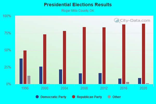
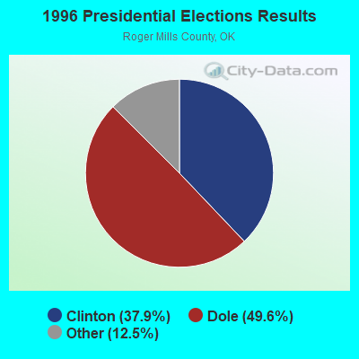
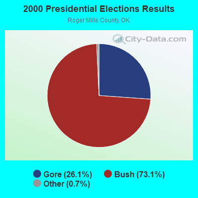
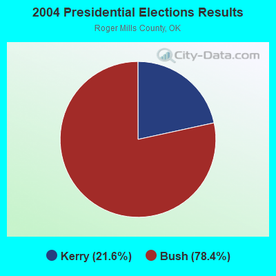
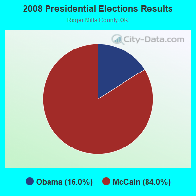
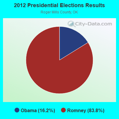
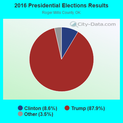
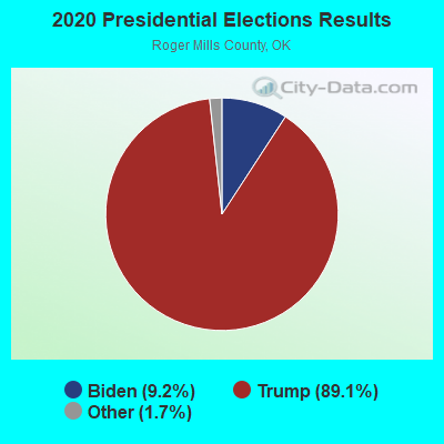
Graphs represent county-level data. Detailed 2008 Election Results
Religion statistics for East Roger Mills, OK (based on Roger Mills County data)
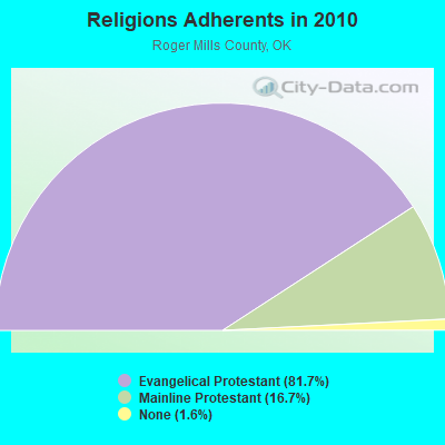
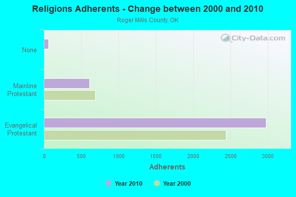
| Religion | Adherents | Congregations |
|---|---|---|
| Evangelical Protestant | 2,978 | 21 |
| Mainline Protestant | 610 | 2 |
| None | 59 | - |
Food Environment Statistics:
| This county: | 3.03 / 10,000 pop. |
| Oklahoma: | 1.97 / 10,000 pop. |
| Here: | 6.07 / 10,000 pop. |
| State: | 0.76 / 10,000 pop. |
| Roger Mills County: | 18.20 / 10,000 pop. |
| Oklahoma: | 4.35 / 10,000 pop. |
| Roger Mills County: | 12.14 / 10,000 pop. |
| State: | 6.89 / 10,000 pop. |
| This county: | 11.2% |
| State: | 10.3% |
| Roger Mills County: | 30.9% |
| State: | 29.2% |
Strongest AM radio stations in East Roger Mills:
- KOMA (1520 AM; 50 kW; OKLAHOMA CITY, OK; Owner: RENDA BROADCASTING CORP. OF NEVADA)
- KGYN (1210 AM; 50 kW; GUYMON, OK; Owner: TELNS BROADCASTING COMPANY, INC.)
- KRMG (740 AM; 50 kW; TULSA, OK; Owner: CXR HOLDINGS, INC.)
- KADS (1240 AM; 1 kW; ELK CITY, OK; Owner: PARAGON COMMUNICATIONS, INC.)
- KFAQ (1170 AM; 50 kW; TULSA, OK; Owner: JOURNAL BROADCAST CORPORATION)
- KJON (850 AM; daytime; 5 kW; ANADARKO, OK; Owner: CARROLLTON BROADCASTING OF TEXAS, LP)
- KICA (980 AM; 50 kW; CLOVIS, NM; Owner: BROADCAST ENTERTAINMENT CORPORATION)
- WBAP (820 AM; 50 kW; FORT WORTH, TX; Owner: WBAP-KSCS OPERATING, LTD.)
- KGNC (710 AM; 10 kW; AMARILLO, TX; Owner: MCC RADIO, LLC)
- KCLI (1320 AM; 1 kW; CLINTON, OK; Owner: WRIGHT BROADCASTING SYSTEMS, INC.)
- KRLD (1080 AM; 50 kW; DALLAS, TX; Owner: TEXAS INFINITY BROADCASTING L.P.)
- KCRC (1390 AM; 10 kW; ENID, OK; Owner: CHISHOLM TRAIL BROADCASTING CO.)
- KMUL (1380 AM; 50 kW; MULESHOE, TX; Owner: BROADCAST ENTERTAINMENT CORPORATION)
Strongest FM radio stations in East Roger Mills:
- K209DI (89.7 FM; ELK CITY, OK; Owner: CALVARY CHAPEL OF TWIN FALLS, INC.)
- KECO (96.5 FM; ELK CITY, OK; Owner: PARAGON COMMUNICATIONS, INC.)
- KXOO (94.3 FM; ELK CITY, OK; Owner: PARAGON COMMUNICATIONS, INC.)
- KRMP (103.5 FM; ANADARKO, OK; Owner: PERRY BROADCASTING OF SOUTHWEST OKLAHOMA, INC.)
- K220FP (91.9 FM; ELK CITY, OK; Owner: AMERICAN FAMILY ASSOCIATION)
- KWOX (101.1 FM; WOODWARD, OK; Owner: OMNI COMMUNICATIONS, INC.)
- KMZE (92.1 FM; WOODWARD, OK; Owner: FM 92 BROADCASTERS, INC.)
- KQMX (95.5 FM; CLINTON, OK; Owner: WRIGHT BROADCASTING SYSTEMS, INC)
- KYCU (89.1 FM; CLINTON, OK; Owner: CAMERON UNIVERSITY)
TV broadcast stations around East Roger Mills:
- KWET (Channel 12; CHEYENNE, OK; Owner: OKLAHOMA EDUCATIONAL TELEVISION AUTHORITY)
- K36AJ (Channel 36; STRONG CITY, OK; Owner: NORTHFORK TV TRANSLATOR SYSTEM)
- K28BY (Channel 28; STRONG CITY, OK; Owner: NORTHFORK TV TRANSLATOR SYSTEM)
- K30EF (Channel 30; STRONG CITY, OK; Owner: NORTHFORK TV TRANSLATOR SYSTEM)
- K38AM (Channel 38; STRONG CITY, OK; Owner: NORTHFORK TV TRANSLATOR SYSTEM)
- K40AG (Channel 40; STRONG CITY, OK; Owner: NORTHFORK TV TRANSLATOR SYSTEM)
- K42AG (Channel 42; STRONG CITY, OK; Owner: NORTHFORK TV TRANSLATOR)
- K32DF (Channel 32; STRONG CITY, OK; Owner: NORTHFORK TV TRANSLATOR SYSTEM)
- KOMI-LP (Channel 24; WOODWARD, OK; Owner: 101 TELEVISION)

- 42.5%Utility gas
- 27.9%Electricity
- 23.6%Bottled, tank, or LP gas
- 4.7%Wood
- 1.3%Other fuel

- 50.8%Utility gas
- 28.6%Bottled, tank, or LP gas
- 17.5%Electricity
- 3.2%Wood
East Roger Mills compared to Oklahoma state average:
- Unemployed percentage significantly below state average.
- Black race population percentage significantly below state average.
- Hispanic race population percentage below state average.
- Foreign-born population percentage significantly below state average.
- Renting percentage below state average.
- Length of stay since moving in significantly above state average.
- Number of rooms per house significantly below state average.
- House age significantly below state average.
- Number of college students below state average.
East Roger Mills on our top lists:
- #24 on the list of "Top 101 cities with the most cars per house, population 500+"
- #42 on the list of "Top 101 counties with the largest number of people without health insurance coverage in 2000"