East Noble, Oklahoma
Submit your own pictures of this place and show them to the world
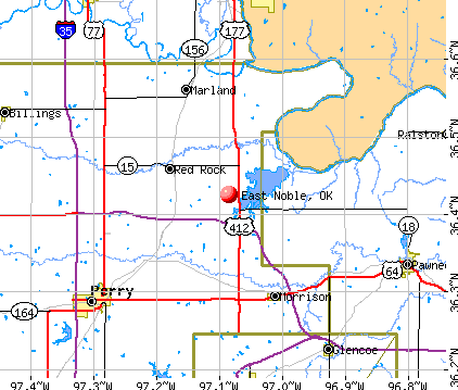
- OSM Map
- General Map
- Google Map
- MSN Map
| Males: 1,379 | |
| Females: 1,401 |
| Median resident age: | 35.0 years |
| Oklahoma median age: | 35.5 years |
Zip code: 74651
| East Noble: | $60,085 |
| OK: | $59,673 |
Estimated per capita income in 2022: $24,978 (it was $13,592 in 2000)
East Noble CCD income, earnings, and wages data
Estimated median house or condo value in 2022: $153,786 (it was $53,100 in 2000)
| East Noble: | $153,786 |
| OK: | $191,700 |
Mean prices in 2022: all housing units: $190,913; detached houses: $205,300; townhouses or other attached units: $73,954; mobile homes: $96,603
Detailed information about poverty and poor residents in East Noble, OK


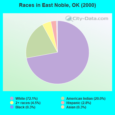
- 2,08072.1%White alone
- 57820.0%American Indian alone
- 1304.5%Two or more races
- 802.8%Hispanic
- 90.3%Black alone
- 80.3%Asian alone
Races in East Noble detailed stats: ancestries, foreign born residents, place of birth
 Recent articles from our blog. Our writers, many of them Ph.D. graduates or candidates, create easy-to-read articles on a wide variety of topics.
Current Local Time: CST time zone
Land area: 288.5 square miles.
Population density: 9.6 people per square mile (very low).

| East Noble CCD: | 0.7% ($350) |
| Oklahoma: | 0.8% ($523) |
Nearest city with pop. 50,000+: Edmond, OK  (57.2 miles , pop. 68,315).
Nearest city with pop. 200,000+: Tulsa, OK (67.1 miles , pop. 393,049).
Nearest city with pop. 1,000,000+: Dallas, TX (251.3 miles , pop. 1,188,580).
Nearest cities:
), ), ), ), )Latitude: 36.43 N, Longitude: 97.08 W
Area code commonly used in this area: 580

| Here: | 2.3% |
| Oklahoma: | 3.2% |
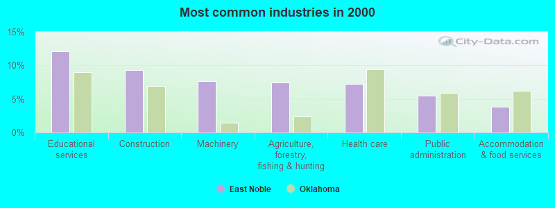
- Educational services (12.1%)
- Construction (9.3%)
- Machinery (7.7%)
- Agriculture, forestry, fishing & hunting (7.4%)
- Health care (7.2%)
- Public administration (5.5%)
- Accommodation & food services (3.9%)
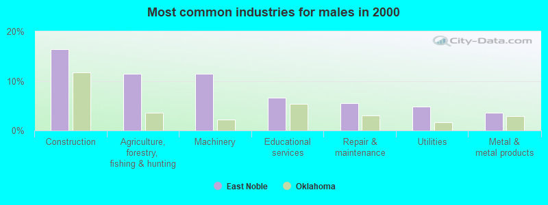
- Construction (16.5%)
- Agriculture, forestry, fishing & hunting (11.5%)
- Machinery (11.5%)
- Educational services (6.7%)
- Repair & maintenance (5.5%)
- Utilities (4.8%)
- Metal & metal products (3.5%)
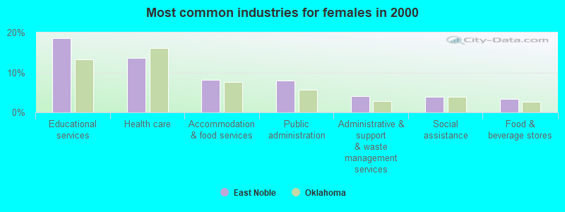
- Educational services (18.7%)
- Health care (13.7%)
- Accommodation & food services (8.2%)
- Public administration (8.0%)
- Administrative & support & waste management services (4.1%)
- Social assistance (3.9%)
- Food & beverage stores (3.4%)
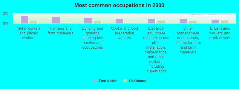
- Metal workers and plastic workers (6.1%)
- Farmers and farm managers (5.3%)
- Building and grounds cleaning and maintenance occupations (4.7%)
- Cooks and food preparation workers (3.9%)
- Electrical equipment mechanics and other installation, maintenance, and repair workers, including supervisors (3.7%)
- Other management occupations, except farmers and farm managers (3.6%)
- Driver/sales workers and truck drivers (3.5%)
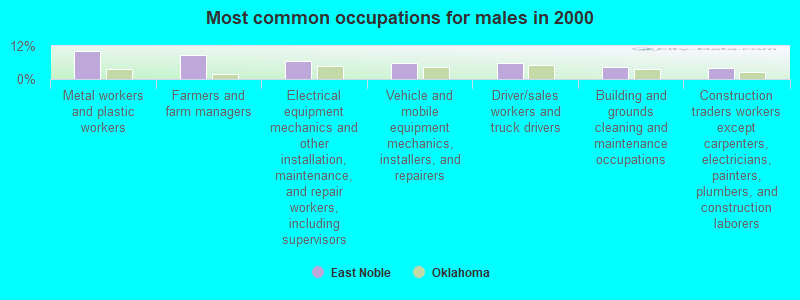
- Metal workers and plastic workers (10.4%)
- Farmers and farm managers (8.7%)
- Electrical equipment mechanics and other installation, maintenance, and repair workers, including supervisors (6.5%)
- Vehicle and mobile equipment mechanics, installers, and repairers (6.0%)
- Driver/sales workers and truck drivers (5.7%)
- Building and grounds cleaning and maintenance occupations (4.5%)
- Construction traders workers except carpenters, electricians, painters, plumbers, and construction laborers (4.0%)
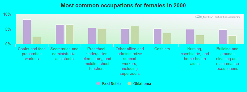
- Cooks and food preparation workers (8.2%)
- Secretaries and administrative assistants (6.5%)
- Preschool, kindergarten, elementary, and middle school teachers (5.5%)
- Other office and administrative support workers, including supervisors (5.1%)
- Cashiers (5.1%)
- Nursing, psychiatric, and home health aides (5.0%)
- Building and grounds cleaning and maintenance occupations (4.8%)
Average climate in East Noble, Oklahoma
Based on data reported by over 4,000 weather stations


(lower is better)
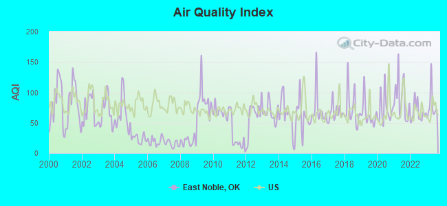
Air Quality Index (AQI) level in 2023 was 78.7. This is about average.
| City: | 78.7 |
| U.S.: | 72.6 |
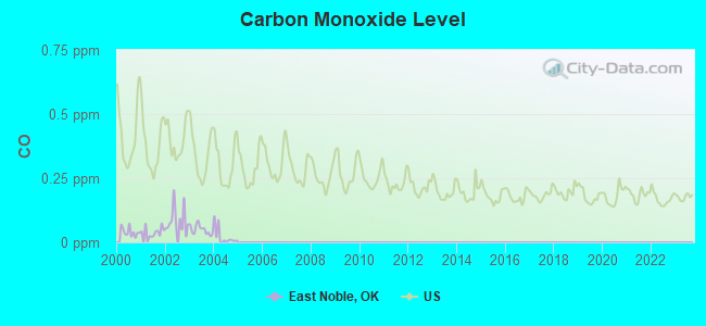
Carbon Monoxide (CO) [ppm] level in 2004 was 0.0211. This is significantly better than average. Closest monitor was 16.4 miles away from the city center.
| City: | 0.0211 |
| U.S.: | 0.2513 |
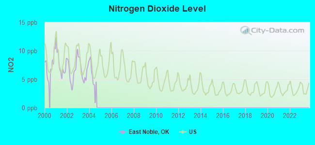
Nitrogen Dioxide (NO2) [ppb] level in 2004 was 4.78. This is about average. Closest monitor was 16.4 miles away from the city center.
| City: | 4.78 |
| U.S.: | 5.11 |
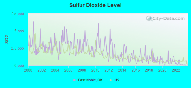
Sulfur Dioxide (SO2) [ppb] level in 2023 was 0.171. This is significantly better than average. Closest monitor was 16.4 miles away from the city center.
| City: | 0.171 |
| U.S.: | 1.515 |
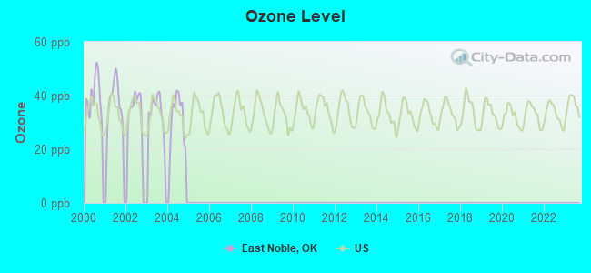
Ozone [ppb] level in 2004 was 32.0. This is about average. Closest monitor was 16.4 miles away from the city center.
| City: | 32.0 |
| U.S.: | 33.3 |
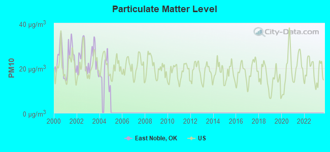
Particulate Matter (PM10) [µg/m3] level in 2004 was 18.4. This is about average. Closest monitor was 16.4 miles away from the city center.
| City: | 18.4 |
| U.S.: | 19.2 |
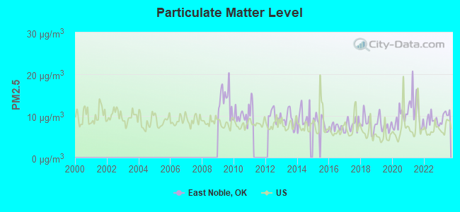
Particulate Matter (PM2.5) [µg/m3] level in 2023 was 10.0. This is worse than average. Closest monitor was 16.4 miles away from the city center.
| City: | 10.0 |
| U.S.: | 8.1 |
Tornado activity:
East Noble-area historical tornado activity is near Oklahoma state average. It is 178% greater than the overall U.S. average.
On 5/25/1955, a category F5 (max. wind speeds 261-318 mph) tornado 23.1 miles away from the East Noble place center killed 20 people and injured 280 people and caused between $5,000,000 and $50,000,000 in damages.
On 5/3/1999, a category F4 (max. wind speeds 207-260 mph) tornado 10.9 miles away from the place center killed 2 people and injured 26 people and caused $13 million in damages.
Earthquake activity:
East Noble-area historical earthquake activity is significantly above Oklahoma state average. It is 918% greater than the overall U.S. average.On 9/3/2016 at 12:02:44, a magnitude 5.8 (5.8 MW, Depth: 3.5 mi, Class: Moderate, Intensity: VI - VII) earthquake occurred 8.7 miles away from the city center
On 11/6/2011 at 03:53:10, a magnitude 5.7 (5.7 MW, Depth: 3.2 mi) earthquake occurred 64.3 miles away from the city center
On 11/7/2016 at 01:44:24, a magnitude 5.0 (5.0 MW, Depth: 2.8 mi) earthquake occurred 33.9 miles away from East Noble center
On 2/13/2016 at 17:07:06, a magnitude 5.1 (5.1 MW, Depth: 5.2 mi) earthquake occurred 90.5 miles away from the city center
On 11/12/2014 at 21:40:00, a magnitude 4.9 (4.9 MW, Depth: 2.5 mi, Class: Light, Intensity: IV - V) earthquake occurred 65.6 miles away from the city center
On 11/5/2011 at 07:12:45, a magnitude 4.8 (4.8 MW, Depth: 1.9 mi) earthquake occurred 63.1 miles away from the city center
Magnitude types: moment magnitude (MW)
Natural disasters:
The number of natural disasters in Noble County (24) is greater than the US average (15).Major Disasters (Presidential) Declared: 15
Emergencies Declared: 5
Causes of natural disasters: Floods: 11, Storms: 11, Tornadoes: 9, Winter Storms: 8, Winds: 4, Ice Storms: 2, Fire: 1, Hurricane: 1, Snowstorm: 1, Other: 1 (Note: some incidents may be assigned to more than one category).
Colleges/universities with over 2000 students nearest to East Noble:
- Oklahoma State University-Main Campus (about 21 miles; Stillwater, OK; Full-time enrollment: 21,700)
- Northern Oklahoma College (about 22 miles; Tonkawa, OK; FT enrollment: 3,414)
- Langston University (about 35 miles; Langston, OK; FT enrollment: 2,075)
- Cowley County Community College (about 45 miles; Arkansas City, KS; FT enrollment: 3,173)
- University of Central Oklahoma (about 58 miles; Edmond, OK; FT enrollment: 13,790)
- Oklahoma Christian University (about 61 miles; Edmond, OK; FT enrollment: 2,173)
- University of Tulsa (about 67 miles; Tulsa, OK; FT enrollment: 3,702)
Points of interest:
Notable locations in East Noble: Otoe-Missouria Indian Agency (A), Bar L Ranch (B), Marland Volunteer Fire Department (C), Morrison Volunteer Fire Department (D), Red Rock Rural Fire Association (E). Display/hide their locations on the map
Cemeteries: Bressie Cemetery (1), Lela Cemetery (2), Morrison Cemetery (3), Cleghorn Cemetery (4), Otoe-Missouria Cemetery (5), Red Rock Cemetery (6). Display/hide their locations on the map
Reservoirs: Upper Black Bear Creek Site 5 Reservoir (A), Upper Black Bear Creek Site 6 Reservoir (B), Upper Black Bear Creek Site 75 Reservoir (C), Upper Black Bear Creek Site 8 Reservoir (D), Longbranch Site 2 Reservoir (E), Lower Red Rock Creek Site 23 Reservoir (F), Lower Red Rock Creek Site 21 Reservoir (G), Lower Red Rock Creek Site 13 Reservoir (H). Display/hide their locations on the map
Creeks: Deadman Creek (A), Bird Creek (B), Cottonwood Creek (C), Coon Creek (D), Legend Creek (E), Spring Creek (F), Skinny Creek (G), Otoe Creek (H), Oak Creek (I). Display/hide their locations on the map
| This place: | 2.8 people |
| Oklahoma: | 2.5 people |
| This place: | 76.5% |
| Whole state: | 66.8% |
| This place: | 5.2% |
| Whole state: | 5.9% |
Likely homosexual households (counted as self-reported same-sex unmarried-partner households)
- Lesbian couples: 0.4% of all households
- Gay men: 0.1% of all households
| This place: | 17.7% |
| Whole state: | 14.7% |
| This place: | 6.1% |
| Whole state: | 6.1% |
For population 15 years and over in East Noble:
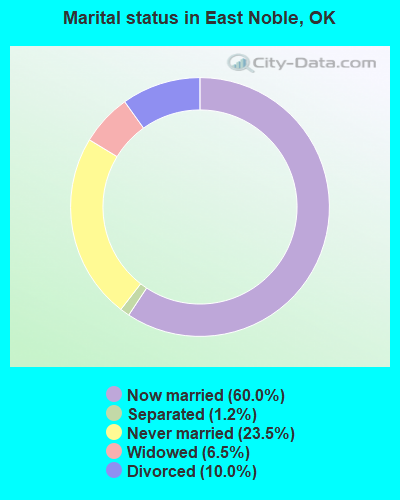
- Never married: 23.5%
- Now married: 60.0%
- Separated: 1.2%
- Widowed: 6.5%
- Divorced: 10.0%
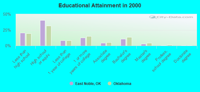
For population 25 years and over in East Noble:
- High school or higher: 79.4%
- Bachelor's degree or higher: 14.5%
- Graduate or professional degree: 4.1%
- Unemployed: 6.6%
- Mean travel time to work (commute): 21.9 minutes
| Here: | 9.7 |
| Oklahoma average: | 11.7 |
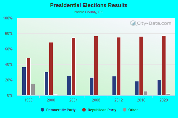
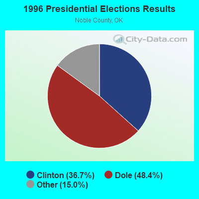
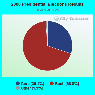
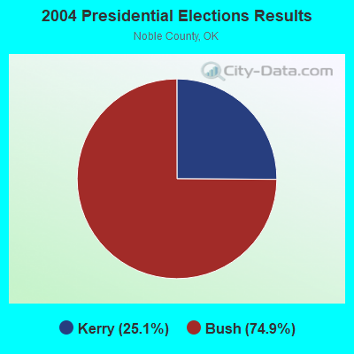
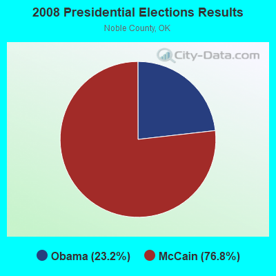
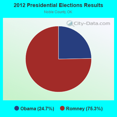
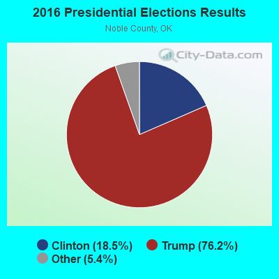
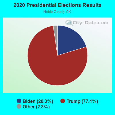
Graphs represent county-level data. Detailed 2008 Election Results
Religion statistics for East Noble, OK (based on Noble County data)
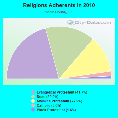
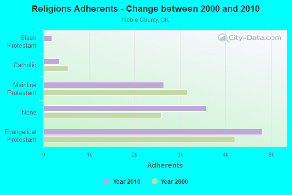
| Religion | Adherents | Congregations |
|---|---|---|
| Evangelical Protestant | 4,816 | 18 |
| Mainline Protestant | 2,642 | 12 |
| Catholic | 350 | 2 |
| Black Protestant | 186 | 1 |
| Other | - | 1 |
| None | 3,567 | - |
Food Environment Statistics:
| Here: | 1.80 / 10,000 pop. |
| Oklahoma: | 1.97 / 10,000 pop. |
| This county: | 0.90 / 10,000 pop. |
| Oklahoma: | 0.76 / 10,000 pop. |
| Noble County: | 3.60 / 10,000 pop. |
| State: | 4.35 / 10,000 pop. |
| This county: | 6.31 / 10,000 pop. |
| Oklahoma: | 6.89 / 10,000 pop. |
| Noble County: | 11.1% |
| Oklahoma: | 10.3% |
| This county: | 30.0% |
| Oklahoma: | 29.2% |
Strongest AM radio stations in East Noble:
- KRMG (740 AM; 50 kW; TULSA, OK; Owner: CXR HOLDINGS, INC.)
- KFAQ (1170 AM; 50 kW; TULSA, OK; Owner: JOURNAL BROADCAST CORPORATION)
- KOMA (1520 AM; 50 kW; OKLAHOMA CITY, OK; Owner: RENDA BROADCASTING CORP. OF NEVADA)
- KTBZ (1430 AM; 25 kW; TULSA, OK; Owner: CLEAR CHANNEL BROADCASTING LICENSES, INC.)
- KCRC (1390 AM; 10 kW; ENID, OK; Owner: CHISHOLM TRAIL BROADCASTING CO.)
- KMUS (1380 AM; 20 kW; MUSKOGEE, OK; Owner: ABC, INC.)
- WBBZ (1230 AM; 1 kW; PONCA CITY, OK; Owner: PONCA CITY PUBLISHING CO.)
- KOKP (1020 AM; 0 kW; PERRY, OK; Owner: TEAM RADIO, L.L.C.)
- KGGF (690 AM; 10 kW; COFFEYVILLE, KS; Owner: KGGF-KUSN, INC.)
- WKY (930 AM; 5 kW; OKLAHOMA CITY, OK; Owner: CITADEL BROADCASTING COMPANY)
- WWLS (640 AM; 5 kW; MOORE, OK; Owner: CITADEL BROADCASTING COMPANY)
- KFTI (1070 AM; 10 kW; WICHITA, KS; Owner: JOURNAL BROADCAST CORPORATION)
- WHB (810 AM; 50 kW; KANSAS CITY, MO; Owner: UNION BROADCASTING, INC.)
Strongest FM radio stations in East Noble:
- KOSU-FM (91.7 FM; STILLWATER, OK; Owner: OKLAHOMA STATE UNIVERSITY)
- KSPI-FM (93.7 FM; STILLWATER, OK; Owner: STILLWATER BROADCASTING, L.L.C.)
- K296EH (107.1 FM; PERRY, OK; Owner: THE LOVE STATION, INC.)
- KLVV (88.7 FM; PONCA CITY, OK; Owner: THE LOVE STATION, INC.)
- KVRO (98.1 FM; STILLWATER, OK; Owner: STILLWATER BROADCASTING, LLC)
- K202CP (88.3 FM; STILLWATER, OK; Owner: PENSACOLA CHRISTIAN COLLEGE, INC.)
- KGFY (105.5 FM; STILLWATER, OK; Owner: STILLWATER BROADCASTING, LLC)
- KQBL (96.9 FM; ENID, OK; Owner: CHAMPLIN BROADCASTING, INC.)
- KPNC (100.9 FM; PONCA CITY, OK; Owner: TEAM RADIO, L.L.C.)
- KOSB (105.1 FM; PERRY, OK; Owner: TEAM RADIO, L.L.C.)
- KLOR-FM (99.3 FM; PONCA CITY, OK; Owner: TEAM RADIO LLC)
- K212DX (90.3 FM; PONCA CITY, ETC., OK; Owner: CREATIVE EDUCATIONAL MEDIA CORP. INC)
TV broadcast stations around East Noble:
- KWTV (Channel 9; OKLAHOMA CITY, OK; Owner: GRIFFIN ENTITIES, L.L.C.)
- K21DF (Channel 21; STILLWATER, OK; Owner: LOCKE SUPPLY CO.)
- KWEM-LP (Channel 31; STILLWATER, OK; Owner: WESTWOOD MEDIA GROUP, INC.)
- KGBN-LP (Channel 27; PONCA CITY, OK; Owner: DIANA KAY HALL)
- K54FZ (Channel 54; PONCA CITY, OK; Owner: LOCKE SUPPLY CO.)
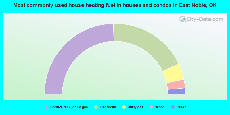
- 49.3%Bottled, tank, or LP gas
- 36.6%Electricity
- 7.4%Utility gas
- 4.0%Wood
- 1.7%Other fuel
- 1.0%Fuel oil, kerosene, etc.
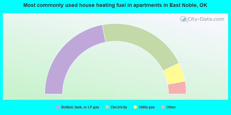
- 44.0%Bottled, tank, or LP gas
- 41.5%Electricity
- 8.7%Utility gas
- 3.3%Wood
- 1.7%Other fuel
- 0.8%Fuel oil, kerosene, etc.
East Noble compared to Oklahoma state average:
- Unemployed percentage below state average.
- Black race population percentage significantly below state average.
- Hispanic race population percentage significantly below state average.
- Foreign-born population percentage significantly below state average.
- Length of stay since moving in significantly above state average.
- Number of rooms per house significantly below state average.
- House age significantly below state average.