East Daggett, Utah
Submit your own pictures of this place and show them to the world
- OSM Map
- General Map
- Google Map
- MSN Map

| Males: 76 | |
| Females: 69 |
| Median resident age: | 38.3 years |
| Utah median age: | 27.1 years |
Zip code: 84023
| East Daggett: | $99,446 |
| UT: | $89,168 |
Estimated per capita income in 2022: $33,144 (it was $18,128 in 2000)
Estimated median house or condo value in 2022: $238,222 (it was $53,800 in 2000)
| East Daggett: | $238,222 |
| UT: | $499,500 |
Mean prices in 2022: all housing units: $325,669; detached houses: $401,539; mobile homes: $151,518


- 14094.0%White alone
- 74.7%Hispanic
- 21.3%Two or more races

 Recent articles from our blog. Our writers, many of them Ph.D. graduates or candidates, create easy-to-read articles on a wide variety of topics.
Current Local Time: MST time zone
Land area: 326.6 square miles.
Population density: 0.4 people per square mile (very low).

| East Daggett CCD: | 0.6% ($342) |
| Utah: | 0.7% ($956) |
Nearest city with pop. 50,000+: Provo, UT  (131.8 miles , pop. 105,166).
Nearest city with pop. 200,000+: Northeast Jefferson, CO (234.5 miles , pop. 450,166).
Nearest city with pop. 1,000,000+: Phoenix, AZ (531.1 miles , pop. 1,321,045).
Nearest cities:
), Latitude: 40.88 N, Longitude: 109.30 W
Area code commonly used in this area: 435


| Here: | 4.8% |
| Utah: | 2.5% |

- Public administration (24.0%)
- Agriculture, forestry, fishing & hunting (15.6%)
- Arts, entertainment, recreation (9.4%)
- Construction (7.3%)
- Social assistance (7.3%)
- Utilities (6.2%)
- Educational services (5.2%)

- Public administration (24.6%)
- Agriculture, forestry, fishing & hunting (19.3%)
- Arts, entertainment, recreation (15.8%)
- Construction (12.3%)
- Utilities (10.5%)
- Sporting goods, camera, hobby & toy stores (5.3%)
- Other transportation, support activities, couriers (5.3%)

- Public administration (23.1%)
- Social assistance (17.9%)
- Educational services (12.8%)
- Agriculture, forestry, fishing & hunting (10.3%)
- U. S. Postal service (10.3%)
- Administrative & support & waste management services (10.3%)
- Book stores & news dealers (7.7%)

- Transportation, tourism, and lodging attendants (9.4%)
- Child care workers (7.3%)
- Building and grounds cleaning and maintenance occupations (6.2%)
- Life and physical scientists (6.2%)
- Life, physical, and social science technicians (5.2%)
- Operations specialties managers, except financial managers (5.2%)
- Other sales and related occupations, including supervisors (5.2%)

- Life and physical scientists (10.5%)
- Transportation, tourism, and lodging attendants (10.5%)
- Other sales and related occupations, including supervisors (8.8%)
- Law enforcement workers, including supervisors (7.0%)
- Supervisors, construction and extraction workers (7.0%)
- Electricians (7.0%)
- Electrical equipment mechanics and other installation, maintenance, and repair workers, including supervisors (7.0%)

- Child care workers (17.9%)
- Building and grounds cleaning and maintenance occupations (10.3%)
- Material recording, scheduling, dispatching, and distributing workers (10.3%)
- Accountants and auditors (7.7%)
- Fire fighting and prevention workers, including supervisors (7.7%)
- Transportation, tourism, and lodging attendants (7.7%)
- Supervisors and other personal care and service workers, except child care workers (7.7%)
Average climate in East Daggett, Utah
Based on data reported by over 4,000 weather stations


Earthquake activity:
East Daggett-area historical earthquake activity is significantly above Utah state average. It is 1440% greater than the overall U.S. average.On 8/18/1959 at 06:37:13, a magnitude 7.7 (7.7 UK, Class: Major, Intensity: VIII - XII) earthquake occurred 264.0 miles away from East Daggett center, causing $26,000,000 total damage
On 10/28/1983 at 14:06:06, a magnitude 7.3 (6.2 MB, 7.3 MS, 7.0 MW) earthquake occurred 318.7 miles away from the city center, causing 2 deaths (2 shaking deaths) and 3 injuries, causing $15,000,000 total damage
On 10/3/1915 at 06:52:48, a magnitude 7.6 (7.6 UK) earthquake occurred 430.9 miles away from East Daggett center
On 3/28/1975 at 02:31:05, a magnitude 6.2 (6.1 MB, 6.0 MS, 6.2 ML, Class: Strong, Intensity: VII - IX) earthquake occurred 182.4 miles away from East Daggett center
On 2/3/1994 at 09:05:04, a magnitude 5.8 (5.4 MB, 5.5 MS, 5.8 MW, 5.8 ML, Depth: 4.9 mi, Class: Moderate, Intensity: VI - VII) earthquake occurred 156.8 miles away from East Daggett center
On 2/3/1995 at 15:26:10, a magnitude 5.3 (5.3 MB, 4.6 MS, Depth: 0.6 mi) earthquake occurred 48.2 miles away from the city center
Magnitude types: body-wave magnitude (MB), local magnitude (ML), surface-wave magnitude (MS), moment magnitude (MW)
Natural disasters:
The number of natural disasters in Daggett County (6) is a lot smaller than the US average (15).Major Disasters (Presidential) Declared: 2
Emergencies Declared: 2
Causes of natural disasters: Floods: 2, Drought: 1, Fire: 1, Hurricane: 1, Landslide: 1, Storm: 1, Other: 1 (Note: some incidents may be assigned to more than one category).
Colleges/universities with over 2000 students nearest to East Daggett:
- Western Wyoming Community College (about 50 miles; Rock Springs, WY; Full-time enrollment: 2,086)
- Brigham Young University-Provo (about 132 miles; Provo, UT; FT enrollment: 33,525)
- Colorado Mesa University (about 132 miles; Grand Junction, CO; FT enrollment: 7,671)
- University of Utah (about 134 miles; Salt Lake City, UT; FT enrollment: 28,454)
- Utah Valley University (about 134 miles; Orem, UT; FT enrollment: 24,403)
- Westminster College (about 135 miles; Salt Lake City, UT; FT enrollment: 2,870)
- Western Governors University (about 136 miles; Salt Lake City, UT; FT enrollment: 31,481)
Points of interest:
Notable locations in East Daggett: Clay Basin Camp (A), Butch Cassidy Hideout (B), Little Hotel Campground (C), Spillway Boat Ramp (D), Red Creek Campground (E), Pugmire Pocket Campground (F), Lodgepole Campground (G), Indian Crossing Campground (H), Greendale Junction (I), Glendale East Campground (J), Dutch John Guard Station (K), Dripping Spring Campground (L), Swallow Canyon Raft Ramp (M), Red Creek Boat Camp (N), Bootleg Campground (O), Indian Crossing Raft Ramp (P), Flaming Gorge National Recreation Area Headquarters (Q), Flaming Gorge Dam Visitor Center (R), Flaming Gorge Dam Bureau of Reclamation Headquarters (S), Antelope Flat Development (T). Display/hide their locations on the map
Church in East Daggett: The Church of Jesus Christ of Latter Day Saints (A). Display/hide its location on the map
Reservoirs: Flaming Gorge Reservoir (A), Browns Park National Wildlife Refuge Reservoir (B). Display/hide their locations on the map
Creeks: Tolivers Creek (A), Goslin Creek (B), Gorge Creek (C), Jackson Creek (D), Spring Creek (E), Crouse Creek (F), Red Creek (G), Little Davenport Creek (H), Birch Creek (I). Display/hide their locations on the map
Parks in East Daggett include: Edith Aspden Park (1), Marshall Draw Wildlife Management Area (2), Browns Park Waterfowl Management Area (3), Little Hole Wildlife Management Area (4), Little Davenport Wildlife Management Area (5), Browns Park Waterfowl Area (6), Clay Basin Wildlife Management Area (7), Goslin Mountain Wildlife Management Area (8), Taylors Flat Wildlife Management Area (9). Display/hide their locations on the map
| This place: | 2.5 people |
| Utah: | 3.1 people |
| This place: | 62.3% |
| Whole state: | 75.2% |
| This place: | 5.8% |
| Whole state: | 4.6% |
No gay or lesbian households reported
| This place: | 1.7% |
| Whole state: | 9.4% |
| This place: | 1.7% |
| Whole state: | 3.9% |
For population 15 years and over in East Daggett:

- Never married: 24.8%
- Now married: 66.4%
- Separated: 0.0%
- Widowed: 0.0%
- Divorced: 8.8%
For population 25 years and over in East Daggett:
- High school or higher: 88.1%
- Bachelor's degree or higher: 13.8%
- Graduate or professional degree: 3.7%
- Unemployed: 8.6%
- Mean travel time to work (commute): 12.2 minutes


| Here: | 8.0 |
| Utah average: | 10.5 |
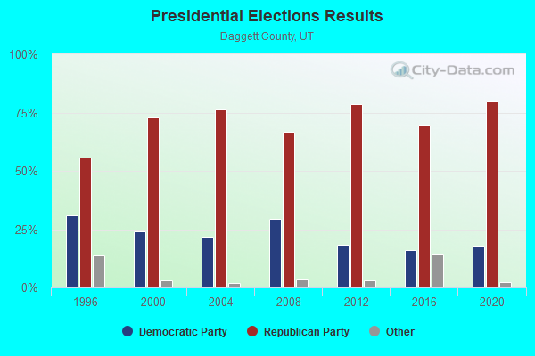
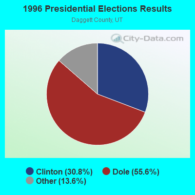
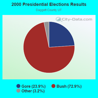
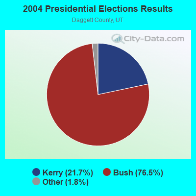
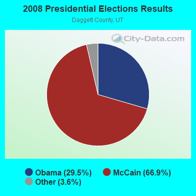
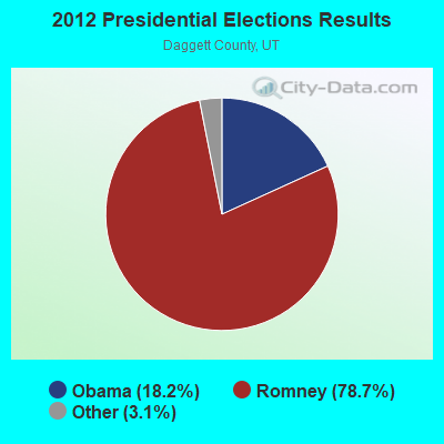
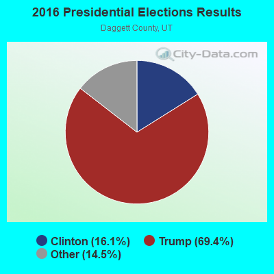
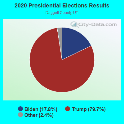
Graphs represent county-level data. Detailed 2008 Election Results
Religion statistics for East Daggett, UT (based on Daggett County data)
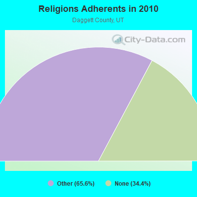
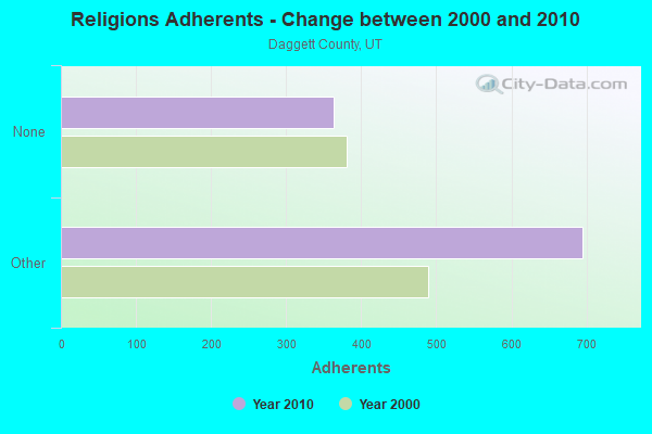
| Religion | Adherents | Congregations |
|---|---|---|
| Other | 695 | 3 |
| None | 364 | - |
Food Environment Statistics:
| Daggett County: | 10.85 / 10,000 pop. |
| Utah: | 1.37 / 10,000 pop. |
| This county: | 10.85 / 10,000 pop. |
| Utah: | 2.82 / 10,000 pop. |
| Here: | 21.69 / 10,000 pop. |
| Utah: | 5.09 / 10,000 pop. |
| Here: | 8.4% |
| Utah: | 6.3% |
| Daggett County: | 24.5% |
| Utah: | 23.6% |
Strongest AM radio stations in East Daggett:
- KVEL (920 AM; 5 kW; VERNAL, UT; Owner: ASHLEY COMMUNICATIONS, INC.)
- KALL (700 AM; 50 kW; NORTH SALT LAKE CITY, UT; Owner: CITICASTERS LICENSES, L.P.)
- KIQN (1010 AM; 50 kW; TOOELE, UT)
- KNZZ (1100 AM; 50 kW; GRAND JUNCTION, CO; Owner: M B C GRAND BROADCASTING, INC.)
- KSL (1160 AM; 50 kW; SALT LAKE CITY, UT; Owner: BONNEVILLE HOLDING COMPANY)
- KRKK (1360 AM; 5 kW; ROCK SPRINGS, WY; Owner: BIG THICKET B/CING CO. OF WY, INC.)
- KNEU (1250 AM; 5 kW; ROOSEVELT, UT; Owner: COUNTRY GOLD BROADCASTING, INC.)
- KLTT (670 AM; 50 kW; COMMERCE CITY, CO; Owner: KLZ RADIO, INC.)
- KKZN (760 AM; 50 kW; THORNTON, CO; Owner: JACOR BROADCASTING OF COLORADO, INC.)
- KTWO (1030 AM; 50 kW; CASPER, WY; Owner: CITICASTERS LICENSES, L.P.)
- KJOL (620 AM; 10 kW; GRAND JUNCTION, CO; Owner: UNITED MINISTRIES)
- KRAI (550 AM; 5 kW; CRAIG, CO; Owner: WILD WEST RADIO, INC.)
- KOAL (750 AM; 10 kW; PRICE, UT; Owner: EASTERN UTAH BROADCASTING CO.)
Strongest FM radio stations in East Daggett:
- KIFX (98.5 FM; ROOSEVELT, UT; Owner: EVANS BROADCASTING, INC.)
- KXRQ (94.3 FM; ROOSEVELT, UT; Owner: UINTA BROADCASTING, L.C.)
- KLCY-FM (105.9 FM; VERNAL, UT; Owner: ASHLEY COMMUNICATIONS, INC.)
- KSIT (104.5 FM; ROCK SPRINGS, WY; Owner: BIG TICKET BROADCASTING COMPANY OF W)
- KQSW (96.5 FM; ROCK SPRINGS, WY; Owner: BIG THICKET BROADCASTING CO OF WY)
- KUWZ (90.5 FM; ROCK SPRINGS, WY; Owner: UNIVERSITY OF WYOMING)
- KYCS (95.1 FM; ROCK SPRINGS, WY; Owner: FAITH BROADCASTING CORPORATION)
- KFRZ (92.1 FM; GREEN RIVER, WY; Owner: WAGONWHEEL COMMUNICATIONS CORP)
TV broadcast stations around East Daggett:
- K25EE (Channel 25; MOUNTAIN VIEW, ETC., UT; Owner: DAGGETT COUNTY TELEVISION DEPT.)

- 48.4%Utility gas
- 41.9%Bottled, tank, or LP gas
- 9.7%Coal or coke

- 72.0%Utility gas
- 28.0%Bottled, tank, or LP gas
East Daggett compared to Utah state average:
- Median house value below state average.
- Black race population percentage significantly below state average.
- Hispanic race population percentage significantly below state average.
- Median age above state average.
- Foreign-born population percentage significantly below state average.
- Length of stay since moving in significantly above state average.
- Number of rooms per house significantly below state average.
- House age significantly below state average.
- Number of college students significantly below state average.
- Percentage of population with a bachelor's degree or higher below state average.