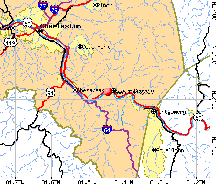
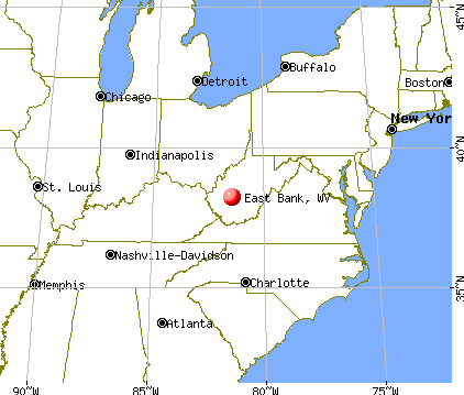
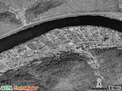
East Bank, West Virginia
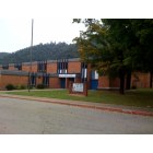
East Bank: The middle school in East Bank.
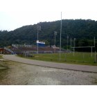
East Bank: This is the football field, Calvert Field, that belongs to East Bank Middle School.
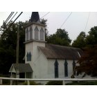
East Bank: The oldest church in East Bank.
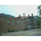
East Bank: City of East Bank WV - Old East Bank High School where Jerry West played his High School Basketball
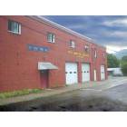
East Bank: East Bank Town Hall and Fire Department
- add
your
Submit your own pictures of this town and show them to the world
- OSM Map
- General Map
- Google Map
- MSN Map
Population change since 2000: -14.7%
 |
| Males: 344 | |
| Females: 452 |
| Median resident age: | 43.8 years |
| West Virginia median age: | 42.9 years |
Zip codes: 25067.
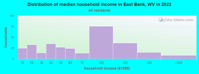
| East Bank: | $52,739 |
| WV: | $54,329 |
Estimated per capita income in 2022: $28,707 (it was $18,419 in 2000)
East Bank town income, earnings, and wages data
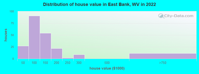
Estimated median house or condo value in 2022: $95,222 (it was $69,100 in 2000)
| East Bank: | $95,222 |
| WV: | $155,100 |
Mean prices in 2022: all housing units: $129,157; detached houses: $140,044; mobile homes: $37,385
Median gross rent in 2022: $809.
(23.4% for White Non-Hispanic residents, 66.7% for Black residents, 100.0% for Hispanic or Latino residents)
Detailed information about poverty and poor residents in East Bank, WV
Compare current foreclosures near East Bank, WV:
| Photo | Address | Area | Beds / Baths | Price | Details |
|---|---|---|---|---|---|

|
#1
Echo Rd
Charleston, WV 25303
|
1,770 sq. feet
|
2 baths 3 beds |
$235,000
|
show details |

|
#2
Frame St
Charleston, WV 25302
|
1,150 sq. feet
|
1 baths 2 beds |
$24,900
|
show details |

|
#3
Cabin Creek Rd
Eskdale, WV 25075
|
1,034 sq. feet
|
2 baths 3 beds |
$75,000
|
show details |

|
#4
Jordan Dr
Costa, WV 25051
|
- sq. feet
|
1 baths 3 beds |
show details | |

|
#5
6th St
Charleston, WV 25302
|
1,115 sq. feet
|
2 baths 3 beds |
show details | |

|
#6
Virginia St E
Charleston, WV 25311
|
3,090 sq. feet
|
2 baths 4 beds |
show details | |

|
#7
Midland Trl
Boomer, WV 25031
|
749 sq. feet
|
1 baths 2 beds |
show details | |

|
#8
Springfield Dr
Charleston, WV 25306
|
1,116 sq. feet
|
1 baths 3 beds |
show details | |

|
#9
Armstrong Creed Rd
Powellton, WV 25161
|
1,281 sq. feet
|
1 baths 3 beds |
show details | |

|
#10
Rosemont Ave
Charleston, WV 25303
|
2,340 sq. feet
|
2 baths 3 beds |
show details |
| Photo | Address | Area | Beds / Baths | Price | Details |
|---|---|---|---|---|---|

|
#11
Hillcrest Dr
Montgomery, WV 25136
|
- sq. feet
|
- baths - beds |
$11,900
|
show details |

|
#12
Summit Dr
Charleston, WV 25302
|
- sq. feet
|
- baths - beds |
$24,900
|
show details |

|
#13
Campbells Creek Dr
Blount, WV 25025
|
- sq. feet
|
- baths - beds |
show details | |

|
#14
Greenwood Ave
Charleston, WV 25302
|
- sq. feet
|
- baths - beds |
show details | |

|
#15
Red Oak St
Charleston, WV 25302
|
- sq. feet
|
- baths - beds |
show details | |

|
#16
Roselane Dr # C
Charleston, WV 25302
|
- sq. feet
|
- baths - beds |
show details | |

|
#17
136th St
Charleston, WV 25315
|
- sq. feet
|
- baths - beds |
show details | |

|
#18
Capitol St # 1000
Charleston, WV 25301
|
- sq. feet
|
- baths - beds |
show details | |

|
#19
Oakwood Ln
Elkview, WV 25071
|
- sq. feet
|
- baths - beds |
show details | |

|
#20
Ginger Dr
Peytona, WV 25154
|
- sq. feet
|
- baths - beds |
show details |
| Photo | Address | Area | Beds / Baths | Price | Details |
|---|---|---|---|---|---|

|
#21
Pence St
Charleston, WV 25303
|
- sq. feet
|
- baths - beds |
show details | |

|
#22
Eds Fork Rd
Clendenin, WV 25045
|
- sq. feet
|
- baths - beds |
show details | |

|
#23
W Gardner Ave
Belle, WV 25015
|
- sq. feet
|
- baths - beds |
show details | |

|
#24
Venable Ave
Charleston, WV 25304
|
- sq. feet
|
- baths - beds |
show details | |

|
#25
Colony Dr
Charleston, WV 25314
|
- sq. feet
|
- baths - beds |
show details | |

|
#26
Maccorkle Ave SE
Charleston, WV 25304
|
- sq. feet
|
- baths - beds |
show details | |

|
#27
Wise Dr
Charleston, WV 25306
|
- sq. feet
|
- baths - beds |
show details | |

|
#28
Campbells Creek Dr
Charleston, WV 25306
|
- sq. feet
|
- baths - beds |
show details | |

|
#29
W 5th Ave
Belle, WV 25015
|
- sq. feet
|
- baths - beds |
show details | |

|
#30
Ravinia Rd
Charleston, WV 25314
|
- sq. feet
|
- baths - beds |
show details |
| Photo | Address | Area | Beds / Baths | Price | Details |
|---|---|---|---|---|---|

|
#31
Vogel Dr
Charleston, WV 25302
|
- sq. feet
|
- baths - beds |
show details | |

|
#32
Hanna Dr
Charleston, WV 25387
|
- sq. feet
|
- baths - beds |
show details | |

|
#33
Gordon Dr
Charleston, WV 25303
|
- sq. feet
|
- baths - beds |
show details | |

|
#34
Grant St
Charleston, WV 25302
|
- sq. feet
|
- baths - beds |
show details | |

|
#35
E Dundon St
Hansford, WV 25103
|
- sq. feet
|
- baths - beds |
show details | |

|
#36
Skyline Dr
Charleston, WV 25302
|
- sq. feet
|
- baths - beds |
show details | |

|
#37
Saint Charles Pl
Charleston, WV 25314
|
- sq. feet
|
- baths - beds |
show details | |

|
#38
Ashby Ave
Charleston, WV 25314
|
- sq. feet
|
- baths - beds |
show details | |

|
#39
Ehman Dr
Charleston, WV 25302
|
- sq. feet
|
- baths - beds |
show details | |

|
#40
Evergreen Dr
Charleston, WV 25302
|
- sq. feet
|
- baths - beds |
show details |
| Photo | Address | Area | Beds / Baths | Price | Details |
|---|---|---|---|---|---|

|
#41
Westmoreland Dr
Charleston, WV 25302
|
- sq. feet
|
- baths - beds |
show details | |

|
#42
Brittany Woods
Charleston, WV 25314
|
- sq. feet
|
- baths - beds |
show details | |

|
#43
Toneys Branch Rd
Bloomingrose, WV 25024
|
- sq. feet
|
- baths - beds |
show details | |

|
#44
Elaine Dr
Charleston, WV 25306
|
- sq. feet
|
- baths - beds |
show details | |

|
#45
Maryland Ave
Charleston, WV 25315
|
- sq. feet
|
- baths - beds |
show details | |

|
#46
3rd Ave W
Montgomery, WV 25136
|
- sq. feet
|
- baths - beds |
show details | |

|
#47
E 6th St
Belle, WV 25015
|
- sq. feet
|
- baths - beds |
show details | |

|
#48
E 4th St
Belle, WV 25015
|
- sq. feet
|
- baths - beds |
show details | |

|
#49
Maccorkle Ave
Charleston, WV 25315
|
- sq. feet
|
- baths - beds |
show details | |

|
Check over 1 million property listings on Foreclosure.com!
|
browse all offers | |||


- 66784.4%White alone
- 9311.8%Two or more races
- 70.9%Hispanic
- 30.4%Black alone
- 10.1%American Indian alone
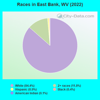
Races in East Bank detailed stats: ancestries, foreign born residents, place of birth
According to our research of West Virginia and other state lists, there was 1 registered sex offender living in East Bank, West Virginia as of May 10, 2024.
The ratio of all residents to sex offenders in East Bank is 750 to 1.
The ratio of registered sex offenders to all residents in this city is lower than the state average.
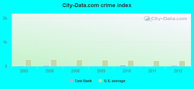
Type |
2009 |
2010 |
2011 |
2012 |
|---|---|---|---|---|
| Murders (per 100,000) | 0 (0.0) | 0 (0.0) | 0 (0.0) | 0 (0.0) |
| Rapes (per 100,000) | 0 (0.0) | 0 (0.0) | 0 (0.0) | 0 (0.0) |
| Robberies (per 100,000) | 0 (0.0) | 0 (0.0) | 0 (0.0) | 0 (0.0) |
| Assaults (per 100,000) | 0 (0.0) | 0 (0.0) | 0 (0.0) | 0 (0.0) |
| Burglaries (per 100,000) | 0 (0.0) | 2 (208.6) | 1 (104.2) | 3 (314.1) |
| Thefts (per 100,000) | 1 (113.3) | 7 (729.9) | 0 (0.0) | 3 (314.1) |
| Auto thefts (per 100,000) | 0 (0.0) | 0 (0.0) | 0 (0.0) | 0 (0.0) |
| Arson (per 100,000) | 0 (0.0) | 0 (0.0) | 0 (0.0) | 0 (0.0) |
| City-Data.com crime index | 4.5 | 43.8 | 7.3 | 34.6 |
The City-Data.com crime index weighs serious crimes and violent crimes more heavily. Higher means more crime, U.S. average is 246.1. It adjusts for the number of visitors and daily workers commuting into cities.
Crime rate in East Bank detailed stats: murders, rapes, robberies, assaults, burglaries, thefts, arson
Full-time law enforcement employees in 2021, including police officers: 1 (1 officers - 1 male; 0 female).
| Officers per 1,000 residents here: | 1.18 |
| West Virginia average: | 1.95 |
 Recent articles from our blog. Our writers, many of them Ph.D. graduates or candidates, create easy-to-read articles on a wide variety of topics.

 | Charleston Urban Renewal Thread (436 replies) |
| Let's be the Mayor. (19 replies) |
| Alternative to Herbert Hoover (26 replies) |
| Starting Over in Charleston - pretty specific on what I prefer!! (50 replies) |
| Census Burea Plans to Combine Charleston and Huntington Urbanized Areas (55 replies) |
| Charleston area (45 replies) |
Latest news from East Bank, WV collected exclusively by city-data.com from local newspapers, TV, and radio stations
Ancestries: English (26.4%), American (23.9%), Irish (14.0%), Italian (10.4%), European (7.7%), German (5.6%).
Current Local Time: EST time zone
Incorporated in 1889
Elevation: 620 feet
Land area: 0.48 square miles.
Population density: 1,671 people per square mile (low).
7 residents are foreign born
| This town: | 0.9% |
| West Virginia: | 1.6% |
Median real estate property taxes paid for housing units with mortgages in 2022: $1,110 (1.2%)
Median real estate property taxes paid for housing units with no mortgage in 2022: $581 (0.6%)
Nearest city with pop. 50,000+: Charleston, WV  (13.8 miles , pop. 53,421).
Nearest city with pop. 200,000+: Columbus, OH (148.1 miles , pop. 711,470).
Nearest city with pop. 1,000,000+: Philadelphia, PA (359.7 miles , pop. 1,517,550).
Nearest cities:
), ), ), ), ), Latitude: 38.22 N, Longitude: 81.44 W
Area code: 304
Property values in East Bank, WV
Single-family new house construction building permits:
- 2021: 1 building, cost: $233,100
- 2020: 1 building, cost: $233,100
- 2012: 1 building, cost: $30,000
- 2011: 1 building, cost: $80,000
- 2009: 1 building, cost: $70,000
- 2008: 2 buildings, average cost: $25,500
- 2007: 1 building, cost: $67,600
- 2006: 4 buildings, average cost: $141,200
- 2005: 2 buildings, average cost: $55,000
- 2004: 2 buildings, average cost: $86,000
- 2003: 1 building, cost: $47,000
| Here: | 3.7% |
| West Virginia: | 4.0% |
- Health care (12.9%)
- Educational services (9.7%)
- Public administration (7.9%)
- Construction (6.7%)
- Accommodation & food services (5.0%)
- Mining, quarrying, oil & gas extraction (4.5%)
- Utilities (4.5%)
- Construction (12.4%)
- Mining, quarrying, oil & gas extraction (8.3%)
- Utilities (8.3%)
- Public administration (6.0%)
- Groceries & related products merchant wholesalers (5.1%)
- Real estate & rental & leasing (5.1%)
- Administrative & support & waste management services (4.1%)
- Health care (23.0%)
- Educational services (16.0%)
- Public administration (10.2%)
- Accommodation & food services (8.0%)
- Finance & insurance (7.5%)
- Food & beverage stores (5.3%)
- Professional, scientific, technical services (4.8%)
- Secretaries and administrative assistants (6.4%)
- Cashiers (5.2%)
- Other sales and related occupations, including supervisors (5.0%)
- Driver/sales workers and truck drivers (4.5%)
- Other production occupations, including supervisors (4.2%)
- Material recording, scheduling, dispatching, and distributing workers (4.0%)
- Electrical equipment mechanics and other installation, maintenance, and repair workers, including supervisors (3.7%)
- Driver/sales workers and truck drivers (8.3%)
- Electrical equipment mechanics and other installation, maintenance, and repair workers, including supervisors (6.9%)
- Other production occupations, including supervisors (6.0%)
- Construction traders workers except carpenters, electricians, painters, plumbers, and construction laborers (6.0%)
- Other sales and related occupations, including supervisors (5.5%)
- Retail sales workers, except cashiers (5.1%)
- Material recording, scheduling, dispatching, and distributing workers (4.6%)
- Secretaries and administrative assistants (13.9%)
- Cashiers (9.1%)
- Information and record clerks, except customer service representatives (7.5%)
- Preschool, kindergarten, elementary, and middle school teachers (4.8%)
- Cooks and food preparation workers (4.8%)
- Financial clerks, except bookkeeping, accounting and auditing clerks (4.8%)
- Other office and administrative support workers, including supervisors (4.8%)
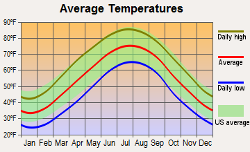
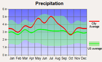
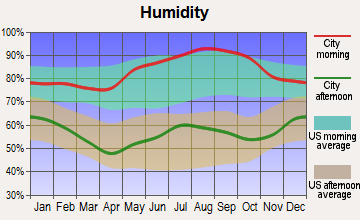
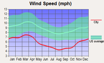
Average climate in East Bank, West Virginia
Based on data reported by over 4,000 weather stations
(lower is better)
Air Quality Index (AQI) level in 2022 was 54.5. This is better than average.
| City: | 54.5 |
| U.S.: | 72.6 |
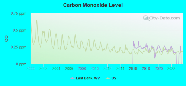
Carbon Monoxide (CO) [ppm] level in 2022 was 0.193. This is better than average. Closest monitor was 12.9 miles away from the city center.
| City: | 0.193 |
| U.S.: | 0.251 |
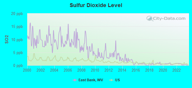
Sulfur Dioxide (SO2) [ppb] level in 2022 was 0.596. This is significantly better than average. Closest monitor was 12.1 miles away from the city center.
| City: | 0.596 |
| U.S.: | 1.515 |
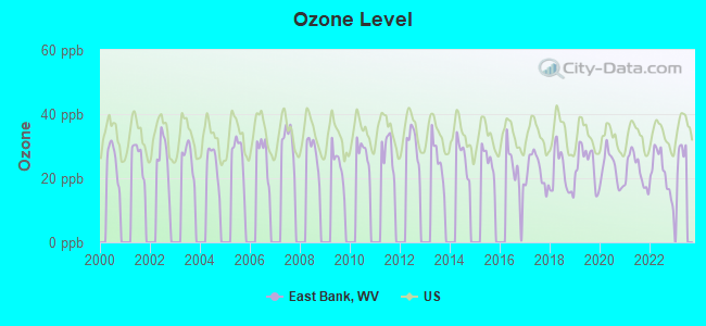
Ozone [ppb] level in 2022 was 21.7. This is significantly better than average. Closest monitor was 12.9 miles away from the city center.
| City: | 21.7 |
| U.S.: | 33.3 |
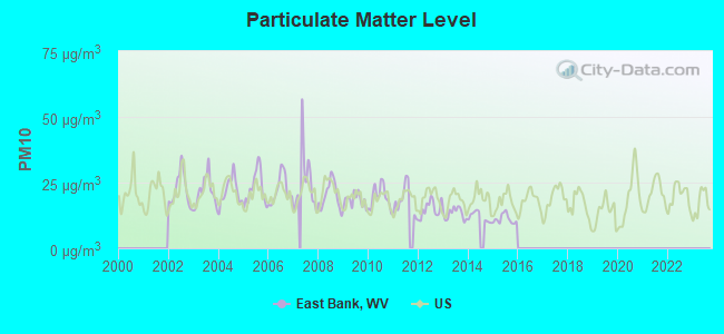
Particulate Matter (PM10) [µg/m3] level in 2015 was 11.1. This is significantly better than average. Closest monitor was 6.8 miles away from the city center.
| City: | 11.1 |
| U.S.: | 19.2 |
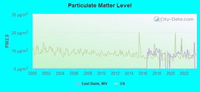
Particulate Matter (PM2.5) [µg/m3] level in 2022 was 7.21. This is about average. Closest monitor was 13.1 miles away from the city center.
| City: | 7.21 |
| U.S.: | 8.11 |
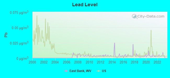
Lead (Pb) [µg/m3] level in 2022 was 0.00387. This is significantly better than average. Closest monitor was 6.9 miles away from the city center.
| City: | 0.00387 |
| U.S.: | 0.00931 |
Tornado activity:
East Bank-area historical tornado activity is below West Virginia state average. It is 79% smaller than the overall U.S. average.
On 4/23/1968, a category F5 (max. wind speeds 261-318 mph) tornado 58.4 miles away from the East Bank town center killed 7 people and injured 93 people and caused between $500,000 and $5,000,000 in damages.
On 4/4/1974, a category F3 (max. wind speeds 158-206 mph) tornado 37.0 miles away from the town center killed one person and injured 11 people and caused between $500,000 and $5,000,000 in damages.
Earthquake activity:
East Bank-area historical earthquake activity is significantly above West Virginia state average. It is 10% smaller than the overall U.S. average.On 8/23/2011 at 17:51:04, a magnitude 5.8 (5.8 MW, Depth: 3.7 mi, Class: Moderate, Intensity: VI - VII) earthquake occurred 192.2 miles away from the city center
On 7/27/1980 at 18:52:21, a magnitude 5.2 (5.1 MB, 4.7 MS, 5.0 UK, 5.2 UK) earthquake occurred 135.8 miles away from East Bank center
On 8/9/2020 at 12:07:37, a magnitude 5.1 (5.1 MW, Depth: 4.7 mi) earthquake occurred 122.0 miles away from the city center
On 9/25/1998 at 19:52:52, a magnitude 5.2 (4.8 MB, 4.3 MS, 5.2 LG, 4.5 MW, Depth: 3.1 mi) earthquake occurred 233.2 miles away from the city center
On 9/7/1988 at 02:28:09, a magnitude 4.6 (4.5 MB, 4.6 LG, Class: Light, Intensity: IV - V) earthquake occurred 132.4 miles away from the city center
On 11/2/2006 at 17:53:02, a magnitude 4.3 (4.3 MB, Depth: 0.6 mi) earthquake occurred 75.0 miles away from East Bank center
Magnitude types: regional Lg-wave magnitude (LG), body-wave magnitude (MB), surface-wave magnitude (MS), moment magnitude (MW)
Natural disasters:
The number of natural disasters in Kanawha County (28) is a lot greater than the US average (15).Major Disasters (Presidential) Declared: 22
Emergencies Declared: 5
Causes of natural disasters: Floods: 15, Storms: 14, Landslides: 8, Winter Storms: 5, Hurricanes: 3, Mudslides: 3, Blizzard: 1, Fire: 1, Heavy Rain: 1, Snowfall: 1, Snowstorm: 1, Tornado: 1, Wind: 1, Other: 2 (Note: some incidents may be assigned to more than one category).
Hospitals and medical centers near East Bank:
- MONTGOMERY GEN. ELDERLY CARE (Nursing Home, about 7 miles away; MONTGOMERY, WV)
- HIGHLAND HOSPITAL (Hospital, about 10 miles away; CHARLESTON, WV)
- HEARTLAND OF CHARLESTON (Nursing Home, about 12 miles away; CHARLESTON, WV)
- FMS - CHARLESTON (Dialysis Facility, about 13 miles away; CHARLESTON, WV)
- AMEDISYS HOME HEALTH OF WEST VIRGINIA (Home Health Center, about 13 miles away; CHARLESTON, WV)
- OAK RIDGE CENTER (Nursing Home, about 13 miles away; CHARLESTON, WV)
- MEADOWBROOK ACRES (Nursing Home, about 13 miles away; CHARLESTON, WV)
Amtrak stations near East Bank:
- 7 miles: MONTGOMERY (WASHINGTON ST. & 3RD AVE.) . Services: public payphones, free short-term parking, free long-term parking, call for taxi service, public transit connection.
- 15 miles: CHARLESTON (350 MCCORKLE AVE. SE) . Services: ticket office, fully wheelchair accessible, enclosed waiting area, public restrooms, public payphones, vending machines, free short-term parking, free long-term parking, call for taxi service, public transit connection.
Colleges/universities with over 2000 students nearest to East Bank:
- West Virginia State University (about 21 miles; Institute, WV; Full-time enrollment: 2,133)
- New River Community and Technical College (about 32 miles; Beckley, WV; FT enrollment: 2,234)
- Marshall University (about 56 miles; Huntington, WV; FT enrollment: 11,450)
- Concord University (about 60 miles; Athens, WV; FT enrollment: 2,698)
- Ashland Community and Technical College (about 68 miles; Ashland, KY; FT enrollment: 2,482)
- West Virginia University at Parkersburg (about 70 miles; Parkersburg, WV; FT enrollment: 2,619)
- Big Sandy Community and Technical College (about 82 miles; Prestonsburg, KY; FT enrollment: 2,660)
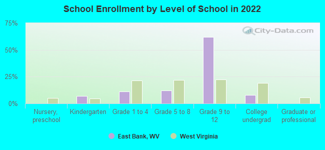
Public elementary/middle school in East Bank:
- EAST BANK MIDDLE SCHOOL (Students: 451, Location: FIRST AND BRANNEN, Grades: 6-8)
User-submitted facts and corrections:
- THE NEXT TOWN TO EAST BANK IS CROWN HILL ,THATS GOING UP TOWARDS MONTGOMERY WV , AND GOING DOWN THE ROAD WOULD BE CABIN CREEK , THESE TOWNS ARE NOT INCORPARATED BUT WE ARE THERE,
added by BARB
Points of interest:
Notable locations in East Bank: Kanawha County Emergency Ambulance Authority Station 129 (A), East Bank Volunteer Fire Department (B). Display/hide their locations on the map
Church in East Bank: Hampton Church (A). Display/hide its location on the map
Cemeteries: Independent Order of Oddfellows Cemetery (1), Good Shepherd Church Cemetery (2). Display/hide their locations on the map
Park in East Bank: Calvert Field (1). Display/hide its location on the map
Drinking water stations with addresses in East Bank and their reported violations in the past:
EAST BANK WATER DEPT (Population served: 975, Purch surface water):Past monitoring violations:
- Monitoring and Reporting (DBP) - Between OCT-2013 and NOV-2013, Contaminant: TTHM. Follow-up actions: St Public Notif requested (FEB-14-2014), St Formal NOV issued (FEB-14-2014), St Compliance achieved (MAY-16-2014)
- Monitoring and Reporting (DBP) - Between OCT-2013 and NOV-2013, Contaminant: Total Haloacetic Acids (HAA5). Follow-up actions: St Public Notif requested (FEB-14-2014), St Formal NOV issued (FEB-14-2014), St Compliance achieved (MAY-16-2014)
- Monitoring of Treatment (SWTR-Filter) - In JUN-2010. Follow-up actions: St Compliance achieved (JUL-31-2010), St Public Notif requested (AUG-20-2010), St Formal NOV issued (AUG-20-2010)
- One minor monitoring violation
| This town: | 2.4 people |
| West Virginia: | 2.4 people |
| This town: | 73.2% |
| Whole state: | 65.8% |
| This town: | 5.4% |
| Whole state: | 6.6% |
Likely homosexual households (counted as self-reported same-sex unmarried-partner households)
- Lesbian couples: 0.3% of all households
- Gay men: 0.3% of all households
For population 15 years and over in East Bank:
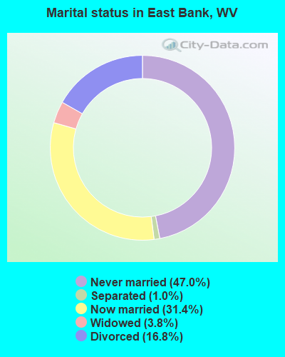
- Never married: 47.0%
- Now married: 31.4%
- Separated: 1.0%
- Widowed: 3.8%
- Divorced: 16.8%
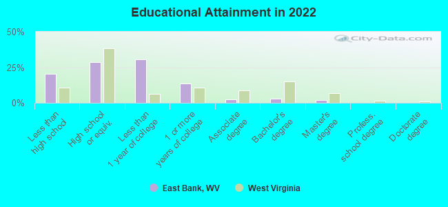
For population 25 years and over in East Bank:
- High school or higher: 79.5%
- Bachelor's degree or higher: 4.6%
- Graduate or professional degree: 2.0%
- Unemployed: 4.7%
- Mean travel time to work (commute): 29.0 minutes
| Here: | 7.2 |
| West Virginia average: | 11.1 |
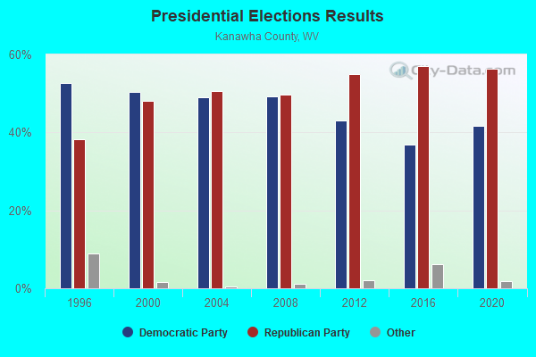
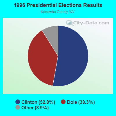
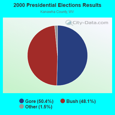
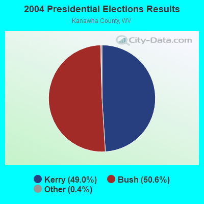
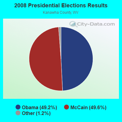
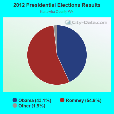
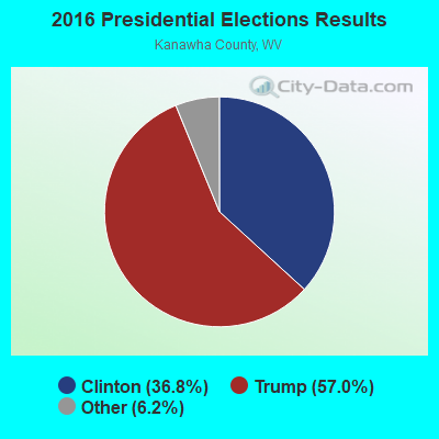
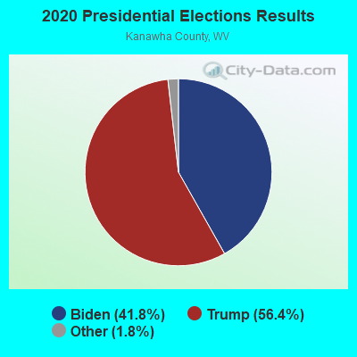
Graphs represent county-level data. Detailed 2008 Election Results
Religion statistics for East Bank, WV (based on Kanawha County data)
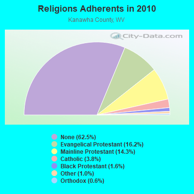
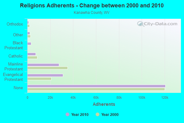
| Religion | Adherents | Congregations |
|---|---|---|
| Evangelical Protestant | 31,202 | 219 |
| Mainline Protestant | 27,583 | 114 |
| Catholic | 7,331 | 11 |
| Black Protestant | 3,114 | 12 |
| Other | 2,020 | 10 |
| Orthodox | 1,136 | 2 |
| None | 120,677 | - |
Food Environment Statistics:
| This county: | 2.46 / 10,000 pop. |
| West Virginia: | 2.41 / 10,000 pop. |
| Kanawha County: | 0.16 / 10,000 pop. |
| West Virginia: | 0.28 / 10,000 pop. |
| This county: | 0.52 / 10,000 pop. |
| State: | 1.09 / 10,000 pop. |
| This county: | 5.13 / 10,000 pop. |
| West Virginia: | 5.38 / 10,000 pop. |
| Kanawha County: | 6.90 / 10,000 pop. |
| West Virginia: | 6.22 / 10,000 pop. |
| Kanawha County: | 12.1% |
| West Virginia: | 12.2% |
| Kanawha County: | 29.6% |
| West Virginia: | 31.1% |
| Kanawha County: | 12.0% |
| West Virginia: | 13.1% |
Health and Nutrition:
| East Bank: | 49.3% |
| West Virginia: | 51.8% |
| Here: | 44.7% |
| State: | 49.7% |
| East Bank: | 29.5 |
| West Virginia: | 28.6 |
| East Bank: | 21.7% |
| State: | 20.4% |
| This city: | 14.6% |
| State: | 9.7% |
| East Bank: | 6.8 |
| West Virginia: | 6.9 |
| This city: | 36.1% |
| West Virginia: | 34.8% |
| This city: | 54.8% |
| State: | 58.4% |
| East Bank: | 75.5% |
| West Virginia: | 78.6% |
More about Health and Nutrition of East Bank, WV Residents
| Local government employment and payroll (March 2022) | |||||
| Function | Full-time employees | Monthly full-time payroll | Average yearly full-time wage | Part-time employees | Monthly part-time payroll |
|---|---|---|---|---|---|
| Other Government Administration | 12 | $40,514 | $40,514 | 1 | $1,495 |
| Judicial and Legal | 1 | $3,465 | $41,580 | 0 | $0 |
| Police Protection - Officers | 0 | $0 | 4 | $5,548 | |
| Totals for Government | 13 | $43,979 | $40,596 | 5 | $7,044 |
East Bank government finances - Expenditure in 2021 (per resident):
- Current Operations - Water Utilities: $165,000 ($207.29)
Sewerage: $156,000 ($195.98)
Police Protection: $64,000 ($80.40)
Financial Administration: $52,000 ($65.33)
Central Staff Services: $29,000 ($36.43)
General Public Buildings: $22,000 ($27.64)
Solid Waste Management: $12,000 ($15.08)
Regular Highways: $5,000 ($6.28)
Local Fire Protection: $2,000 ($2.51)
Judicial and Legal Services: $1,000 ($1.26)
Parks and Recreation: $1,000 ($1.26)
- Other Capital Outlay - Water Utilities: $13,000 ($16.33)
- Total Salaries and Wages: $271,000 ($340.45)
East Bank government finances - Revenue in 2021 (per resident):
- Charges - Sewerage: $172,000 ($216.08)
Other: $23,000 ($28.89)
- Miscellaneous - General Revenue - Other: $18,000 ($22.61)
- Revenue - Water Utilities: $133,000 ($167.09)
- State Intergovernmental - General Local Government Support: $2,000 ($2.51)
- Tax - Property: $78,000 ($97.99)
Occupation and Business License - Other: $47,000 ($59.05)
Public Utilities Sales: $19,000 ($23.87)
Other License: $1,000 ($1.26)
East Bank government finances - Debt in 2021 (per resident):
- Long Term Debt - Beginning Outstanding - Unspecified Public Purpose: $11,000 ($13.82)
Retired Unspecified Public Purpose: $11,000 ($13.82)
East Bank government finances - Cash and Securities in 2021 (per resident):
- Other Funds - Cash and Securities: $75,000 ($94.22)
Strongest AM radio stations in East Bank:
- WCAW (680 AM; 10 kW; CHARLESTON, WV; Owner: WEST VIRGINIA RADIO CORPORATION OF CHARLESTON)
- WOAY (860 AM; 10 kW; OAK HILL, WV; Owner: COMMISSIONED COMMUNICATIONS, INC.)
- WCHS (580 AM; 5 kW; CHARLESTON, WV; Owner: WEST VIRGINIA RADIO CORPORATION OF CHARLESTON)
- WVTS (950 AM; 5 kW; CHARLESTON, WV; Owner: BRISTOL BROADCASTING COMPANY, INC.)
- WMON (1340 AM; 1 kW; MONTGOMERY, WV; Owner: L.M. COMMUNICATIONS OF KENTUCKY, LLC)
- WSCW (1410 AM; daytime; 5 kW; SOUTH CHARLESTON, WV; Owner: L.M. COMMUNICATIONS OF KENTUCKY, LLC)
- WIWS (1070 AM; daytime; 10 kW; BECKLEY, WV; Owner: SOUTHERN COMMUNICATIONS CORPORATION)
- WJLS (560 AM; 5 kW; BECKLEY, WV; Owner: FIRST MEDIA RADIO, LLC)
- WWNR (620 AM; 5 kW; BECKLEY, WV; Owner: DYNASTAR COMMUNICATIONS, INC.)
- WTVN (610 AM; 50 kW; COLUMBUS, OH; Owner: CITICASTERS LICENSES, L.P.)
- WSWW (1490 AM; 1 kW; CHARLESTON, WV; Owner: WEST VIRGINIA RADIO CORPORATION OF CHARLESTON)
- WBGS (1030 AM; daytime; 10 kW; POINT PLEASANT, WV; Owner: BIG RIVER RADIO, INC.)
- WVOW (1290 AM; 5 kW; LOGAN, WV; Owner: LOGAN BROADCASTING CORPORATION)
Strongest FM radio stations in East Bank:
- WKVW (93.3 FM; MONTGOMERY, WV; Owner: EDUCATIONAL MEDIA FOUNDATION)
- WKAZ (107.3 FM; MIAMI, WV; Owner: WEST VIRGINIA RADIO CORPORATION OF CHARLESTON)
- WXAF (90.9 FM; CHARLESTON, WV; Owner: MARANATHA BROADCASTING, INC.)
- WCIR-FM (103.7 FM; BECKLEY, WV; Owner: SOUTHERN COMMUNICATIONS CORPORATION)
- WKLC-FM (105.1 FM; ST. ALBANS, WV; Owner: WKLC, INC.)
- WKWS (96.1 FM; CHARLESTON, WV; Owner: WEST VIRGINIA RADIO CORPORATION OF CHARLESTON)
- WVAF (99.9 FM; CHARLESTON, WV; Owner: WEST VIRGINIA RADIO CORPORATION OF CHARLESTON)
- WVPN (88.5 FM; CHARLESTON, WV; Owner: WEST VIRGINIA EDUCATIONAL BROADCASTING AUTHORITY)
- WDBS (97.1 FM; SUTTON, WV; Owner: SUMMIT MEDIA BROADCASTING, L.L.C.)
- WRVZ (98.7 FM; POCATALICO, WV; Owner: WEST VIRGINIA RADIO CORPORATION OF CHARLESTON)
- WZAC-FM (92.5 FM; DANVILLE, WV; Owner: PRICE BROADCASTING COMPANY)
- WVSR-FM (102.7 FM; CHARLESTON, WV; Owner: BRISTOL BROADCASTING COMPANY, INC.)
- WAXS (94.1 FM; OAK HILL, WV; Owner: PLATEAU BROADCASTING, INC.)
- WZJO (94.5 FM; DUNBAR, WV; Owner: BRISTOL BROADCASTING COMPANY, INC)
- WQBE-FM (97.5 FM; CHARLESTON, WV; Owner: BRISTOL BROADCASTING COMPANY)
- WVPB (91.7 FM; BECKLEY, WV; Owner: WEST VIRGINIA EDUCATIONAL BROADCASTING AUTHORITY)
- WMTD-FM (102.3 FM; HINTON, WV; Owner: SOUTHERN COMMUNICATIONS CORPORATION)
- WVWV (89.9 FM; HUNTINGTON, WV; Owner: WEST VIRGINIA EDUCATIONAL BROADCASTING AUTHORITY)
- W208AK (89.5 FM; CHARLESTON, WV; Owner: LOWER OHIO VALLEY EDUCATIONAL CORP.)
- WAMX (106.3 FM; MILTON, WV; Owner: CAPSTAR TX LIMITED PARTNERSHIP)
TV broadcast stations around East Bank:
- WVAH-TV (Channel 11; CHARLESTON, WV; Owner: WVAH LICENSEE, LLC)
- WCHS-TV (Channel 8; CHARLESTON, WV; Owner: WCHS LICENSEE, LLC)
- WLPX-TV (Channel 29; CHARLESTON, WV; Owner: PAXSON CHARLESTON LICENSE, INC.)
- WOAY-TV (Channel 4; OAK HILL, WV; Owner: THOMAS BROADCASTING CO.)
- WPBY-TV (Channel 33; HUNTINGTON, WV; Owner: WEST VIRGINIA EDUCATIONAL BROADCASTING AUTHORITY)
- WOWK-TV (Channel 13; HUNTINGTON, WV; Owner: WEST VIRGINIA MEDIA HOLDINGS, LLC)
- W16CE (Channel 16; CHARLESTON, WV; Owner: EMMIS TELEVISION LICENSE CORPORATION)
East Bank fatal accident list:
Jan 13, 2009 03:07 PM, Sr-61, Lat: 38.213906, Lon: -81.450578, Vehicles: 1, Persons: 1, Fatalities: 1
Oct 2, 2006 06:56 AM, Sr-61, Lat: 38.213500, Lon: -81.452460, Vehicles: 2, Persons: 2, Fatalities: 1
Apr 17, 2003 10:23 AM, Walnut Street, Vehicles: 1, Persons: 1, Fatalities: 1
Aug 13, 1991 12:45 AM, Walnut, Vehicles: 1, Persons: 1, Fatalities: 1
Apr 30, 1986 01:05 PM, 61, Vehicles: 2, Persons: 2, Fatalities: 1
- National Bridge Inventory (NBI) Statistics
- 1Number of bridges
- 650Total average daily traffic
- 39Total average daily truck traffic
FCC Registered Antenna Towers:
9 (See the full list of FCC Registered Antenna Towers in East Bank)FCC Registered Broadcast Land Mobile Towers:
1- 2507 First Ave (Lat: 38.454278 Lon: -81.435944), Call Sign: WYG256,
Assigned Frequencies: 155.145 MHz, 155.745 MHz, Grant Date: 09/12/2023, Expiration Date: 11/14/2033, Registrant: Metro 911 Kanawha County Emergency Operations Center, 200 Peyton Way, Charleston, WV 25309-8627, Phone: (304) 746-7911, Fax: (304) 746-7914, Email:
FCC Registered Amateur Radio Licenses:
3- Call Sign: N3IWJ, Licensee ID: L00654457, Grant Date: 03/14/2013, Expiration Date: 06/05/2023, Certifier: Klaus M Gross, Registrant: Klaus M Gross, East Bank, WV 25067
- Call Sign: N3OOT, Licensee ID: L00611897, Grant Date: 03/09/2023, Expiration Date: 03/23/2033, Registrant: James V Haines, East Bank, WV 25067
- Call Sign: KE8SBG, Licensee ID: L02449292, Grant Date: 05/14/2021, Expiration Date: 05/14/2031, Certifier: Russell L Kees, Registrant: Russell L Kees, 145 Evans St, East Bank, WV 25067
2002 - 2018 National Fire Incident Reporting System (NFIRS) incidents
- Fire incident types reported to NFIRS in East Bank, WV
- 12072.7%Structure Fires
- 2515.2%Outside Fires
- 148.5%Other
- 63.6%Mobile Property/Vehicle Fires
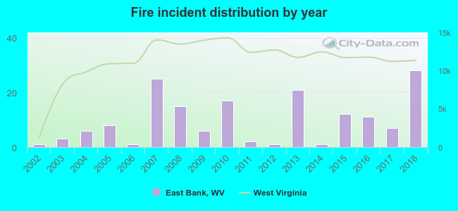 Based on the data from the years 2002 - 2018 the average number of fire incidents per year is 10. The highest number of fires - 28 took place in 2018, and the least - 1 in 2002. The data has an increasing trend.
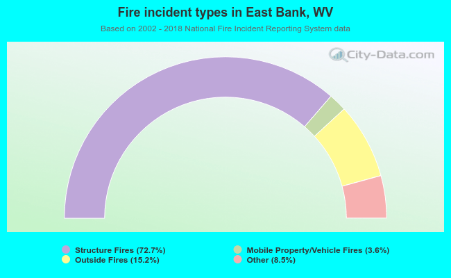 When looking into fire subcategories, the most incidents belonged to: Structure Fires (72.7%), and Outside Fires (15.2%).
| Most common first names in East Bank, WV among deceased individuals | ||
| Name | Count | Lived (average) |
|---|---|---|
| William | 16 | 71.1 years |
| James | 13 | 71.8 years |
| John | 12 | 65.8 years |
| Mary | 11 | 82.5 years |
| Margaret | 10 | 78.5 years |
| George | 8 | 69.0 years |
| Clarence | 6 | 62.0 years |
| Robert | 6 | 57.2 years |
| Thelma | 6 | 76.3 years |
| Betty | 5 | 67.0 years |
| Most common last names in East Bank, WV among deceased individuals | ||
| Last name | Count | Lived (average) |
|---|---|---|
| Johnson | 7 | 72.1 years |
| Hudnall | 6 | 69.2 years |
| White | 5 | 60.4 years |
| Walker | 5 | 75.0 years |
| Young | 5 | 83.2 years |
| Howery | 5 | 75.8 years |
| Wilson | 5 | 73.0 years |
| Blair | 5 | 74.6 years |
| Morrison | 5 | 71.0 years |
| Keeney | 5 | 77.6 years |
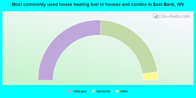
- 51.8%Utility gas
- 44.1%Electricity
- 1.8%No fuel used
- 1.4%Other fuel
- 0.9%Wood
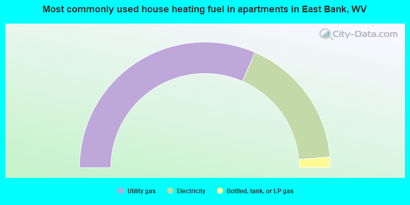
- 63.0%Utility gas
- 34.2%Electricity
- 2.7%Bottled, tank, or LP gas
East Bank compared to West Virginia state average:
- Median house value below state average.
- Unemployed percentage significantly below state average.
- Black race population percentage significantly below state average.
- Hispanic race population percentage below state average.
- Foreign-born population percentage below state average.
- Length of stay since moving in significantly above state average.
- Number of college students significantly below state average.
- Percentage of population with a bachelor's degree or higher significantly below state average.