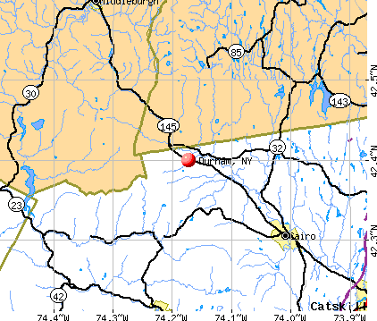
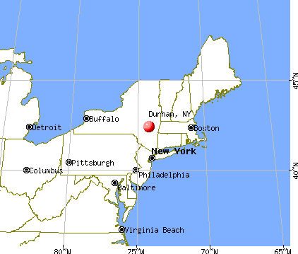
Durham, New York
Submit your own pictures of this town and show them to the world
- OSM Map
- General Map
- Google Map
- MSN Map
Population change since 2000: +5.1%
 |
| Males: 1,375 | |
| Females: 1,350 |
| Median resident age: | 47.1 years |
| New York median age: | 40.7 years |
Zip codes: 12423.
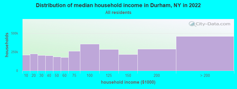
| Durham: | $64,551 |
| NY: | $79,557 |
Estimated per capita income in 2022: $38,327 (it was $18,705 in 2000)
Durham town income, earnings, and wages data
Estimated median house or condo value in 2022: $237,677 (it was $91,300 in 2000)
| Durham: | $237,677 |
| NY: | $400,400 |
Mean prices in 2022: all housing units: $264,283; detached houses: $262,676; townhouses or other attached units: $340,037; in 2-unit structures: $437,043; in 3-to-4-unit structures: $263,666; in 5-or-more-unit structures: $906,197; mobile homes: $216,338
Detailed information about poverty and poor residents in Durham, NY

Compare current foreclosures near Durham, NY:
| Photo | Address | Area | Beds / Baths | Price | Details |
|---|---|---|---|---|---|

|
#1
Sutton Road
Durham, NY 12422
|
1,900 sq. feet
|
2 baths 4 beds |
show details | |

|
#2
Mccafferty Road
Durham, NY 12422
|
1,056 sq. feet
|
1 baths 2 beds |
show details | |

|
#3
Route 23
Durham, NY 12422
|
- sq. feet
|
- baths - beds |
show details | |

|
#4
Mount Greenery Rd
Windham, NY 12496
|
1,856 sq. feet
|
2 baths 3 beds |
show details | |

|
#5
Vista Ridge Rd
East Jewett, NY 12424
|
1,728 sq. feet
|
2 baths 4 beds |
show details | |

|
#6
County Road 402
Westerlo, NY 12193
|
- sq. feet
|
1 baths 2 beds |
show details | |

|
#7
Division Street
Hunter, NY 12442
|
2,336 sq. feet
|
1 baths 5 beds |
show details | |

|
#8
Jarvis Rd S
Ravena, NY 12143
|
1,431 sq. feet
|
2 baths 3 beds |
show details | |

|
#9
Vosenkill Rd
Catskill, NY 12414
|
1,185 sq. feet
|
1 baths 2 beds |
show details | |

|
#10
Jesse Ann Cir
Earlton, NY 12058
|
1,560 sq. feet
|
2 baths 3 beds |
show details |
| Photo | Address | Area | Beds / Baths | Price | Details |
|---|---|---|---|---|---|

|
#11
Game Farm Rd
Catskill, NY 12414
|
1,152 sq. feet
|
2 baths 3 beds |
show details | |

|
#12
Schmidt Dr
Cairo, NY 12413
|
960 sq. feet
|
1 baths 2 beds |
show details | |

|
#13
High Hill Rd
Earlton, NY 12058
|
1,260 sq. feet
|
2 baths 3 beds |
show details | |

|
#14
James Rd
Catskill, NY 12414
|
1,600 sq. feet
|
1 baths 3 beds |
show details | |

|
#15
Hinrichsen Heights Rd
Coxsackie, NY 12051
|
1,854 sq. feet
|
3 baths 5 beds |
show details | |

|
#16
Helderberg Trl
Berne, NY 12023
|
1,998 sq. feet
|
1 baths 3 beds |
show details | |

|
#17
County Route 26
Climax, NY 12042
|
1,966 sq. feet
|
1 baths 3 beds |
show details | |

|
#18
Ford Hill Rd
Hunter, NY 12442
|
1,536 sq. feet
|
1 baths 4 beds |
show details | |

|
#19
Country Estates Rd
Greenville, NY 12083
|
1,588 sq. feet
|
2 baths 2 beds |
show details | |

|
#20
State Route 85
Westerlo, NY 12193
|
2,250 sq. feet
|
1 baths 3 beds |
show details |
| Photo | Address | Area | Beds / Baths | Price | Details |
|---|---|---|---|---|---|

|
#21
County Route 408
Westerlo, NY 12193
|
1,176 sq. feet
|
1 baths 3 beds |
show details | |

|
#22
County Route 75
Greenville, NY 12083
|
512 sq. feet
|
1 baths 2 beds |
show details | |

|
#23
Brookhaven Dr
East Berne, NY 12059
|
1,780 sq. feet
|
1 baths 1 beds |
show details | |

|
#24
Switzkill Rd
Berne, NY 12023
|
1,344 sq. feet
|
2 baths 3 beds |
show details | |

|
#25
Potic Mountain Rd
Catskill, NY 12414
|
1,200 sq. feet
|
1 baths 3 beds |
show details | |

|
#26
Kaaterskill Ave
Palenville, NY 12463
|
1,976 sq. feet
|
2 baths 3 beds |
show details | |

|
#27
Howard Dr
West Coxsackie, NY 12192
|
1,064 sq. feet
|
1 baths 3 beds |
show details | |

|
#28
High Acres Ln
Greenville, NY 12083
|
2,712 sq. feet
|
2 baths 4 beds |
show details | |

|
#29
Shady Ln
Coeymans Hollow, NY 12046
|
780 sq. feet
|
- baths - beds |
show details | |

|
#30
North Rd
Clarksville, NY 12041
|
- sq. feet
|
- baths - beds |
show details |
| Photo | Address | Area | Beds / Baths | Price | Details |
|---|---|---|---|---|---|

|
#31
W Hawley Ln
West Coxsackie, NY 12192
|
- sq. feet
|
- baths - beds |
show details | |

|
#32
Potic Mountain Rd
Catskill, NY 12414
|
- sq. feet
|
- baths - beds |
show details | |

|
#33
Udell Rd
Dormansville, NY 12055
|
- sq. feet
|
- baths - beds |
show details | |

|
#34
Haluska Ln
Berne, NY 12023
|
- sq. feet
|
- baths - beds |
show details | |

|
#35
Clum Hill Rd
Elka Park, NY 12427
|
- sq. feet
|
- baths - beds |
show details | |

|
#36
5 Mile Woods Rd
Catskill, NY 12414
|
- sq. feet
|
- baths - beds |
show details | |

|
#37
Timm Rd
Prattsville, NY 12468
|
- sq. feet
|
- baths - beds |
show details | |

|
#38
Star Rd
Coeymans, NY 12045
|
- sq. feet
|
- baths - beds |
show details | |

|
#39
Woodstock Rd # 30
East Berne, NY 12059
|
184 sq. feet
|
- baths - beds |
show details | |

|
#40
Honey Hollow Rd
Earlton, NY 12058
|
- sq. feet
|
- baths - beds |
show details |
| Photo | Address | Area | Beds / Baths | Price | Details |
|---|---|---|---|---|---|

|
#41
Main St
Tannersville, NY 12485
|
- sq. feet
|
- baths - beds |
show details | |

|
#42
Potic Creek Rd
Earlton, NY 12058
|
- sq. feet
|
- baths - beds |
show details | |

|
#43
Flinn Rd
Cornwallville, NY 12418
|
812 sq. feet
|
- baths - beds |
show details | |

|
#44
Tuscany Mdws
East Durham, NY 12423
|
- sq. feet
|
- baths - beds |
show details | |

|
#45
Tuscany Mdws
East Durham, NY 12423
|
- sq. feet
|
- baths - beds |
show details | |

|
#46
Hideway Corners Ext
Greenville, NY 12083
|
- sq. feet
|
- baths - beds |
show details | |

|
#47
County Road 20
Cairo, NY 12413
|
- sq. feet
|
- baths - beds |
show details | |

|
#48
Route 145
Preston Hollow, NY 12469
|
- sq. feet
|
- baths - beds |
show details | |

|
#49
Roosevelt Ave
Cairo, NY 12413
|
- sq. feet
|
- baths - beds |
show details | |

|
Check over 1 million property listings on Foreclosure.com!
|
browse all offers | |||

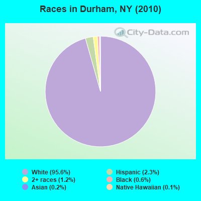
- 2,60695.6%White alone
- 622.3%Hispanic
- 321.2%Two or more races
- 150.6%Black alone
- 60.2%Asian alone
- 40.1%Native Hawaiian and Other
Pacific Islander alone
Races in Durham detailed stats: ancestries, foreign born residents, place of birth
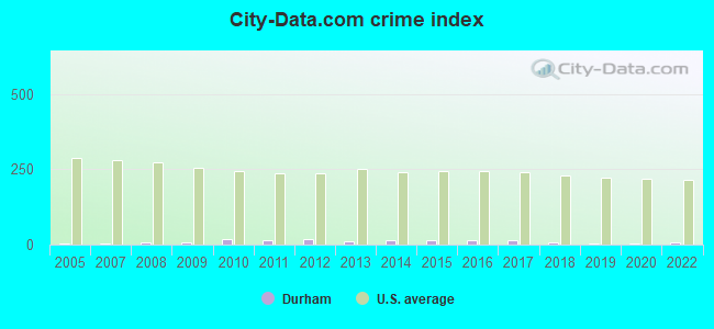
Type |
2009 |
2010 |
2011 |
2012 |
2013 |
2014 |
2015 |
2016 |
2017 |
2018 |
2019 |
2020 |
2022 |
|---|---|---|---|---|---|---|---|---|---|---|---|---|---|
| Murders (per 100,000) | 0 (0.0) | 0 (0.0) | 0 (0.0) | 0 (0.0) | 0 (0.0) | 0 (0.0) | 0 (0.0) | 0 (0.0) | 0 (0.0) | 0 (0.0) | 0 (0.0) | 0 (0.0) | 0 (0.0) |
| Rapes (per 100,000) | 0 (0.0) | 0 (0.0) | 0 (0.0) | 0 (0.0) | 0 (0.0) | 0 (0.0) | 0 (0.0) | 0 (0.0) | 0 (0.0) | 0 (0.0) | 0 (0.0) | 0 (0.0) | 0 (0.0) |
| Robberies (per 100,000) | 0 (0.0) | 0 (0.0) | 0 (0.0) | 0 (0.0) | 0 (0.0) | 0 (0.0) | 0 (0.0) | 0 (0.0) | 0 (0.0) | 0 (0.0) | 0 (0.0) | 0 (0.0) | 0 (0.0) |
| Assaults (per 100,000) | 0 (0.0) | 0 (0.0) | 0 (0.0) | 0 (0.0) | 0 (0.0) | 1 (37.2) | 0 (0.0) | 0 (0.0) | 0 (0.0) | 0 (0.0) | 0 (0.0) | 0 (0.0) | 0 (0.0) |
| Burglaries (per 100,000) | 1 (37.2) | 5 (183.5) | 4 (146.1) | 3 (110.1) | 3 (111.1) | 0 (0.0) | 2 (75.0) | 4 (150.3) | 2 (75.2) | 0 (0.0) | 0 (0.0) | 0 (0.0) | 1 (37.1) |
| Thefts (per 100,000) | 2 (74.5) | 5 (183.5) | 3 (109.6) | 8 (293.7) | 3 (111.1) | 4 (148.8) | 7 (262.5) | 3 (112.7) | 7 (263.3) | 6 (225.9) | 3 (112.8) | 1 (37.8) | 4 (148.2) |
| Auto thefts (per 100,000) | 0 (0.0) | 0 (0.0) | 0 (0.0) | 0 (0.0) | 0 (0.0) | 0 (0.0) | 0 (0.0) | 0 (0.0) | 0 (0.0) | 0 (0.0) | 0 (0.0) | 0 (0.0) | 0 (0.0) |
| Arson (per 100,000) | 0 (0.0) | 0 (0.0) | 0 (0.0) | 0 (0.0) | 0 (0.0) | 0 (0.0) | 0 (0.0) | 0 (0.0) | 0 (0.0) | 0 (0.0) | 0 (0.0) | 0 (0.0) | 0 (0.0) |
| City-Data.com crime index | 5.6 | 20.2 | 14.6 | 19.5 | 12.2 | 13.4 | 15.7 | 15.0 | 15.8 | 9.0 | 4.5 | 1.5 | 8.5 |
The City-Data.com crime index weighs serious crimes and violent crimes more heavily. Higher means more crime, U.S. average is 246.1. It adjusts for the number of visitors and daily workers commuting into cities.
Crime rate in Durham detailed stats: murders, rapes, robberies, assaults, burglaries, thefts, arson
 Recent articles from our blog. Our writers, many of them Ph.D. graduates or candidates, create easy-to-read articles on a wide variety of topics.

 | Who is voting for Hochul and why? (452 replies) |
| Safest Cities from natural disasters (70 replies) |
| Santos indicted (45 replies) |
| Bills want new stadium to be completely funded by taxpayer money (998 replies) |
| Syracuse, NY Population Rankings Using Different Definitions (20 replies) |
| Airline announces new service at Albany International Airport (0 replies) |
Latest news from Durham, NY collected exclusively by city-data.com from local newspapers, TV, and radio stations
Ancestries: Irish (30.4%), German (16.8%), Italian (11.4%), United States (11.3%), Polish (6.0%), French (4.7%).
Current Local Time: EST time zone
Land area: 49.2 square miles.
Population density: 55 people per square mile (very low).
266 residents are foreign born (9.0% Europe).
| This town: | 10.3% |
| New York: | 20.4% |
| Durham town: | 2.3% ($2,099) |
| New York: | 1.9% ($2,847) |
Nearest city with pop. 50,000+: Albany, NY  (26.7 miles , pop. 95,658).
Nearest city with pop. 200,000+: Bronx, NY (107.0 miles , pop. 1,332,650).
Nearest cities:
), ), ), )Latitude: 42.38 N, Longitude: 74.14 W
Area code commonly used in this area: 518
Durham tourist attractions:
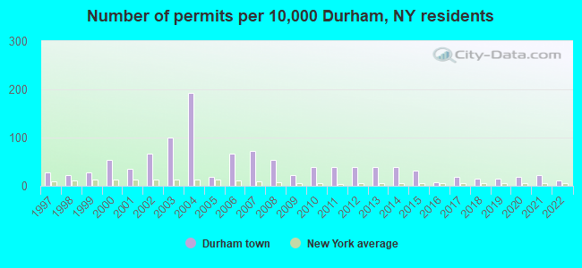
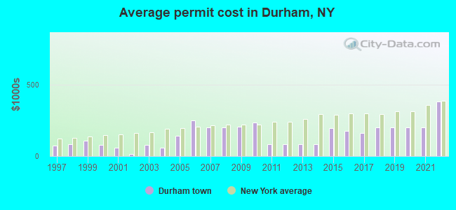
Single-family new house construction building permits:
- 2022: 3 buildings, average cost: $383,300
- 2021: 6 buildings, average cost: $200,000
- 2020: 5 buildings, average cost: $200,000
- 2019: 4 buildings, average cost: $200,000
- 2018: 4 buildings, average cost: $200,000
- 2017: 5 buildings, average cost: $160,000
- 2016: 2 buildings, average cost: $175,000
- 2015: 8 buildings, average cost: $193,800
- 2014: 10 buildings, average cost: $80,800
- 2013: 10 buildings, average cost: $80,800
- 2012: 10 buildings, average cost: $80,800
- 2011: 10 buildings, average cost: $80,800
- 2010: 10 buildings, average cost: $235,700
- 2009: 6 buildings, average cost: $205,800
- 2008: 14 buildings, average cost: $200,000
- 2007: 19 buildings, average cost: $200,000
- 2006: 17 buildings, average cost: $250,000
- 2005: 5 buildings, average cost: $142,000
- 2004: 50 buildings, average cost: $57,900
- 2003: 26 buildings, average cost: $77,600
- 2002: 17 buildings, average cost: $15,000
- 2001: 9 buildings, average cost: $59,000
- 2000: 14 buildings, average cost: $77,200
- 1999: 7 buildings, average cost: $107,100
- 1998: 6 buildings, average cost: $84,300
- 1997: 7 buildings, average cost: $72,900
| Here: | 4.3% |
| New York: | 4.4% |
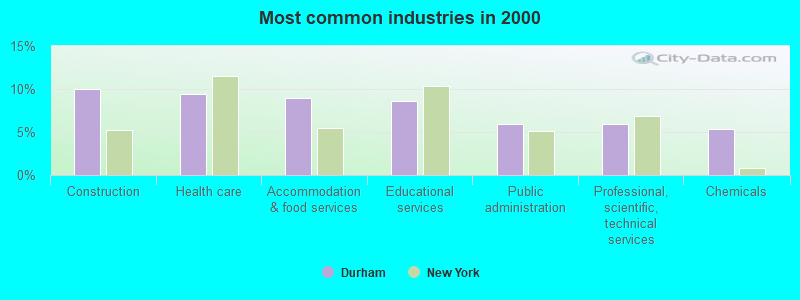
- Construction (10.0%)
- Health care (9.4%)
- Accommodation & food services (9.0%)
- Educational services (8.6%)
- Public administration (5.9%)
- Professional, scientific, technical services (5.9%)
- Chemicals (5.4%)
- Construction (18.5%)
- Accommodation & food services (7.9%)
- Public administration (7.8%)
- Truck transportation (5.8%)
- Professional, scientific, technical services (5.1%)
- Finance & insurance (4.8%)
- Arts, entertainment, recreation (4.1%)
- Health care (17.4%)
- Educational services (14.8%)
- Accommodation & food services (10.2%)
- Chemicals (8.0%)
- Professional, scientific, technical services (6.8%)
- Religious, grantmaking, civic, professional, similar organizations (3.9%)
- Textile mills & textile products (3.7%)
- Other office and administrative support workers, including supervisors (6.5%)
- Other management occupations, except farmers and farm managers (5.8%)
- Driver/sales workers and truck drivers (5.6%)
- Other production occupations, including supervisors (4.9%)
- Secretaries and administrative assistants (3.4%)
- Preschool, kindergarten, elementary, and middle school teachers (3.3%)
- Material recording, scheduling, dispatching, and distributing workers (2.8%)
- Driver/sales workers and truck drivers (9.7%)
- Other management occupations, except farmers and farm managers (5.3%)
- Construction laborers (4.1%)
- Material recording, scheduling, dispatching, and distributing workers (3.9%)
- Other production occupations, including supervisors (3.7%)
- Vehicle and mobile equipment mechanics, installers, and repairers (3.7%)
- Carpenters (3.4%)
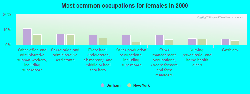
- Other office and administrative support workers, including supervisors (10.9%)
- Secretaries and administrative assistants (7.4%)
- Preschool, kindergarten, elementary, and middle school teachers (6.4%)
- Other production occupations, including supervisors (6.4%)
- Other management occupations, except farmers and farm managers (6.4%)
- Nursing, psychiatric, and home health aides (4.3%)
- Cashiers (4.1%)
Average climate in Durham, New York
Based on data reported by over 4,000 weather stations


(lower is better)
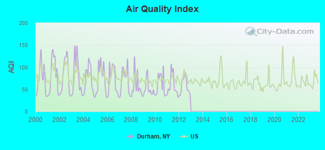
Air Quality Index (AQI) level in 2012 was 56.9. This is better than average.
| City: | 56.9 |
| U.S.: | 72.6 |
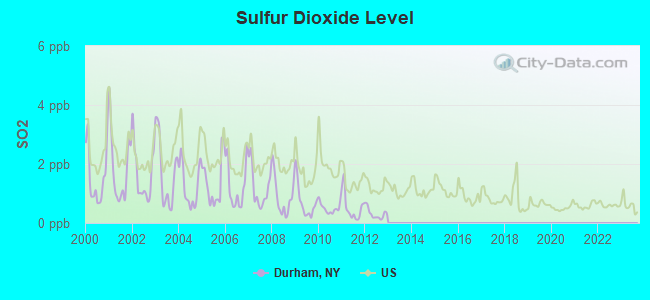
Sulfur Dioxide (SO2) [ppb] level in 2012 was 0.314. This is significantly better than average. Closest monitor was 21.0 miles away from the city center.
| City: | 0.314 |
| U.S.: | 1.515 |
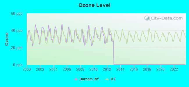
Ozone [ppb] level in 2012 was 32.5. This is about average. Closest monitor was 24.3 miles away from the city center.
| City: | 32.5 |
| U.S.: | 33.3 |
Tornado activity:
Durham-area historical tornado activity is above New York state average. It is 45% smaller than the overall U.S. average.
On 7/10/1989, a category F4 (max. wind speeds 207-260 mph) tornado 5.8 miles away from the Durham town center injured 20 people and caused between $5,000,000 and $50,000,000 in damages.
On 8/28/1973, a category F4 tornado 37.1 miles away from the town center killed 4 people and injured 36 people and caused between $5,000,000 and $50,000,000 in damages.
Earthquake activity:
Durham-area historical earthquake activity is significantly above New York state average. It is 67% smaller than the overall U.S. average.On 10/7/1983 at 10:18:46, a magnitude 5.3 (5.1 MB, 5.3 LG, 5.1 ML, Class: Moderate, Intensity: VI - VII) earthquake occurred 109.2 miles away from the city center
On 4/20/2002 at 10:50:47, a magnitude 5.3 (5.3 ML, Depth: 3.0 mi) earthquake occurred 149.1 miles away from the city center
On 4/20/2002 at 10:50:47, a magnitude 5.2 (5.2 MB, 4.2 MS, 5.2 MW, 5.0 MW) earthquake occurred 147.3 miles away from Durham center
On 1/19/1982 at 00:14:42, a magnitude 4.7 (4.5 MB, 4.7 MD, 4.5 LG, Class: Light, Intensity: IV - V) earthquake occurred 150.3 miles away from Durham center
On 6/17/1991 at 08:53:16, a magnitude 4.1 (4.0 MB, 4.0 LG, Depth: 3.1 mi) earthquake occurred 32.3 miles away from Durham center
On 8/23/2011 at 17:51:04, a magnitude 5.8 (5.8 MW, Depth: 3.7 mi) earthquake occurred 368.5 miles away from the city center
Magnitude types: regional Lg-wave magnitude (LG), body-wave magnitude (MB), duration magnitude (MD), local magnitude (ML), surface-wave magnitude (MS), moment magnitude (MW)
Natural disasters:
The number of natural disasters in Greene County (25) is a lot greater than the US average (15).Major Disasters (Presidential) Declared: 14
Emergencies Declared: 10
Causes of natural disasters: Floods: 6, Hurricanes: 6, Storms: 6, Winter Storms: 4, Snowstorms: 3, Blizzards: 2, Power Outage: 1, Tornado: 1, Tropical Storm: 1, Other: 2 (Note: some incidents may be assigned to more than one category).
Amtrak station near Durham:
Colleges/universities with over 2000 students nearest to Durham:
- Excelsior College (about 27 miles; Albany, NY; Full-time enrollment: 4,723)
- SUNY at Albany (about 27 miles; Albany, NY; FT enrollment: 15,490)
- SUNY College of Agriculture and Technology at Cobleskill (about 27 miles; Cobleskill, NY; FT enrollment: 2,455)
- The College of Saint Rose (about 27 miles; Albany, NY; FT enrollment: 4,085)
- Bard College (about 28 miles; Annandale-On-Hudson, NY; FT enrollment: 3,137)
- Siena College (about 31 miles; Loudonville, NY; FT enrollment: 3,153)
- Schenectady County Community College (about 32 miles; Schenectady, NY; FT enrollment: 3,676)
Points of interest:
Notable locations in Durham: Armstrongs Elk Farm (A), East Durham Volunteer Fire Company (B), Oak Hill Durham Volunteer Fire Company (C). Display/hide their locations on the map
Churches in Durham include: Saint Marys Church (A), Durham United Methodist Church (B). Display/hide their locations on the map
Cemeteries: Pratt Cemetery (1), Snyder Cemetery (2), Stone Bridge Cemetery (3), Cornwallville Cemetery (4), West Durham Cemetery (5), East Durham Cemetery (6), Durham Cemetery (7). Display/hide their locations on the map
Creeks: Tenmile Creek (A), Basic Creek (B), Fall Creek (C), Bowery Creek (D), Cornwallville Creek (E), Thorp Creek (F). Display/hide their locations on the map
Birthplace of: Blossom Dearie - Female singer.
Drinking water stations with addresses in Durham and their reported violations in the past:
HULL-O-FARMS (Address: 10 Cochrane Road , Population served: 26, Groundwater):Past monitoring violations:
- 6 routine major monitoring violations
| This town: | 2.4 people |
| New York: | 2.6 people |
| This town: | 66.8% |
| Whole state: | 63.5% |
| This town: | 10.4% |
| Whole state: | 6.8% |
Likely homosexual households (counted as self-reported same-sex unmarried-partner households)
- Lesbian couples: 0.3% of all households
- Gay men: 0.5% of all households
| This town: | 11.5% |
| Whole state: | 14.6% |
| This town: | 5.6% |
| Whole state: | 7.4% |
For population 15 years and over in Durham:
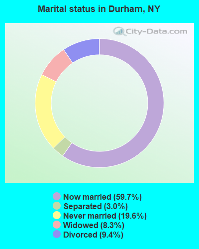
- Never married: 19.6%
- Now married: 59.7%
- Separated: 3.0%
- Widowed: 8.3%
- Divorced: 9.4%
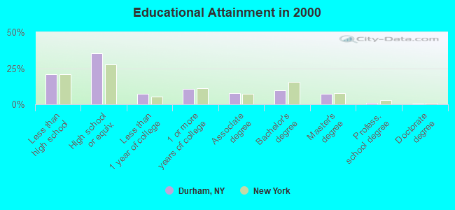
For population 25 years and over in Durham:
- High school or higher: 79.0%
- Bachelor's degree or higher: 18.0%
- Graduate or professional degree: 8.3%
- Unemployed: 11.1%
- Mean travel time to work (commute): 31.6 minutes
| Here: | 10.9 |
| New York average: | 14.2 |

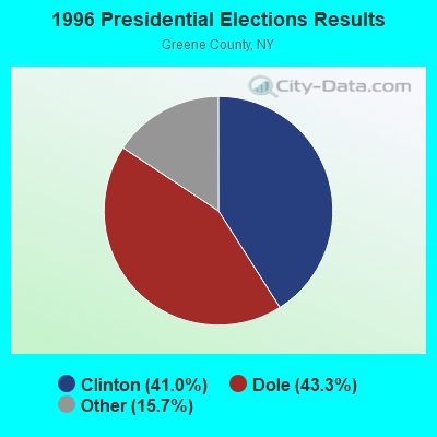
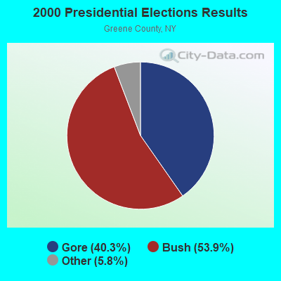
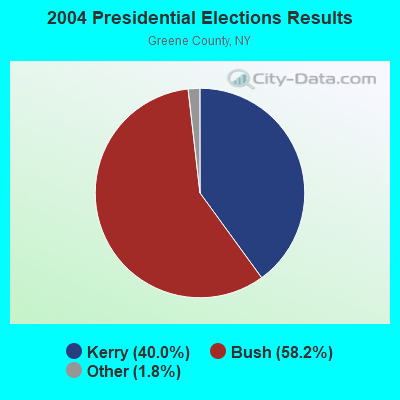
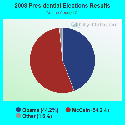
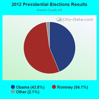
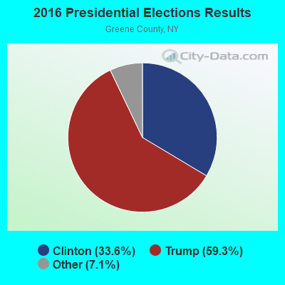

Graphs represent county-level data. Detailed 2008 Election Results
Religion statistics for Durham, NY (based on Greene County data)
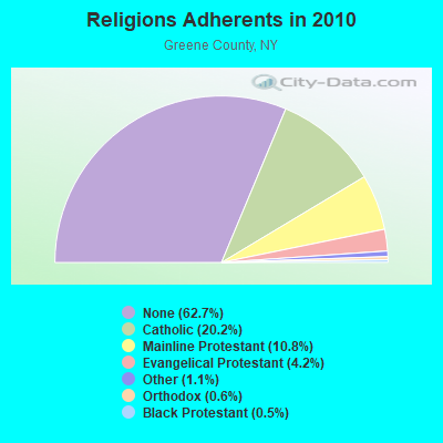
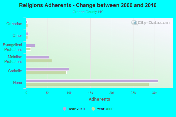
| Religion | Adherents | Congregations |
|---|---|---|
| Catholic | 9,935 | 9 |
| Mainline Protestant | 5,329 | 34 |
| Evangelical Protestant | 2,063 | 19 |
| Other | 520 | 7 |
| Orthodox | 280 | 1 |
| Black Protestant | 232 | 2 |
| None | 30,862 | - |
Food Environment Statistics:
| Greene County: | 2.65 / 10,000 pop. |
| New York: | 4.13 / 10,000 pop. |
| Here: | 1.02 / 10,000 pop. |
| New York: | 0.92 / 10,000 pop. |
| Here: | 5.71 / 10,000 pop. |
| New York: | 1.68 / 10,000 pop. |
| Greene County: | 16.92 / 10,000 pop. |
| New York: | 8.82 / 10,000 pop. |
| Greene County: | 7.7% |
| New York: | 8.2% |
| Greene County: | 24.5% |
| New York: | 23.8% |
| Greene County: | 16.5% |
| New York: | 15.6% |
Strongest AM radio stations in Durham:
- WGY (810 AM; 50 kW; SCHENECTADY, NY; Owner: CLEAR CHANNEL BROADCASTING LICENSES, INC.)
- WPTR (1540 AM; 50 kW; ALBANY, NY; Owner: KIMTRON, INC.)
- WROW (590 AM; 5 kW; ALBANY, NY; Owner: 6 JOHNSON ROAD LICENSES, INC.)
- WNNZ (640 AM; 50 kW; WESTFIELD, MA; Owner: CLEAR CHANNEL BROADCASTING LICENSES, INC.)
- WTIC (1080 AM; 50 kW; HARTFORD, CT; Owner: INFINITY RADIO OPERATIONS INC.)
- WMCA (570 AM; 50 kW; NEW YORK, NY; Owner: SALEM MEDIA OF NEW YORK, LLC)
- WFAN (660 AM; 50 kW; NEW YORK, NY; Owner: INFINITY BROADCASTING OPERATIONS, INC.)
- WTMM (1300 AM; 5 kW; RENSSELAER, NY; Owner: REGENT LICENSEE OF MANSFIELD, INC.)
- WDDY (1460 AM; 5 kW; ALBANY, NY)
- WABC (770 AM; 50 kW; NEW YORK, NY; Owner: WABC-AM RADIO, INC.)
- WOR (710 AM; 50 kW; NEW YORK, NY; Owner: BUCKLEY BROADCASTING CORPORATION)
- WOFX (980 AM; 5 kW; TROY, NY)
- WCBS (880 AM; 50 kW; NEW YORK, NY; Owner: INFINITY BROADCASTING OPERATIONS, INC.)
Strongest FM radio stations in Durham:
- WRIP (97.9 FM; WINDHAM, NY; Owner: RIP RADIO, LLC)
- WAMK (90.9 FM; KINGSTON, NY; Owner: W A M C)
- WFGB (89.7 FM; KINGSTON, NY; Owner: SOUND OF LIFE, INC.)
- WAJZ (96.3 FM; VOORHEESVILLE, NY; Owner: 6 JOHNSON ROAD LICENSES, INC.)
- WZMR (104.9 FM; ALTAMONT, NY; Owner: 6 JOHNSON ROAD LICENSES, INC.)
- WGKR (105.3 FM; GRAND GORGE, NY; Owner: SOUND OF LIFE, INC.)
- WYJB (95.5 FM; ALBANY, NY; Owner: 6 JOHNSON ROAD LICENSES, INC.)
- WMYY (97.3 FM; SCHOHARIE, NY; Owner: CAPITAL MEDIA CORPORATION)
- WGNA-FM (107.7 FM; ALBANY, NY; Owner: REGENT LICENSEE OF MANSFIELD, INC.)
- WMHT-FM (89.1 FM; SCHENECTADY, NY; Owner: WMHT EDUCATIONAL TELECOMMUNICATIONS)
- WRVE (99.5 FM; SCHENECTADY, NY; Owner: CLEAR CHANNEL BROADCASTING LICENSES, INC.)
- WPYX (106.5 FM; ALBANY, NY; Owner: CAPSTAR TX LIMITED PARTNERSHIP)
- WVCR-FM (88.3 FM; LOUDONVILLE, NY; Owner: SIENA COLLEGE)
- WFLY (92.3 FM; TROY, NY; Owner: 6 JOHNSON ROAD LICENSES, INC.)
- WAMC-FM (90.3 FM; ALBANY, NY; Owner: WAMC)
- WHVP (91.1 FM; HUDSON, NY; Owner: SOUND OF LIFE, INC.)
- WPDH (101.5 FM; POUGHKEEPSIE, NY; Owner: CUMULUS LICENSING CORP.)
- WFKP (99.3 FM; ELLENVILLE, NY; Owner: CLEAR CHANNEL BROADCASTING LICENSES, INC.)
- W282AD (104.3 FM; EAST WINDHAM, NY; Owner: CHRISTIAN MEDIA ASSOCIATES, INC.)
- WFNP (88.7 FM; ROSENDALE, NY; Owner: STATE UNIVERSITY OF NEW YORK)
TV broadcast stations around Durham:
- WNYT (Channel 13; ALBANY, NY; Owner: WNYT-TV, LLC)
- WEWB-TV (Channel 45; SCHENECTADY, NY; Owner: WEWB, L.L.C.)
- WXXA-TV (Channel 23; ALBANY, NY; Owner: CLEAR CHANNEL BROADCASTING LICENSES, INC.)
- WRGB (Channel 6; SCHENECTADY, NY; Owner: FREEDOM BROADCASTING OF NEW YORK, INC)
- WMHT (Channel 17; SCHENECTADY, NY; Owner: WMHT EDUCATIONAL TELECOMMUNICATIONS)
- WTEN (Channel 10; ALBANY, NY; Owner: YOUNG BROADCASTING OF ALBANY, INC.)
- National Bridge Inventory (NBI) Statistics
- 24Number of bridges
- 177ft / 53.8mTotal length
- $23,392,000Total costs
- 16,510Total average daily traffic
- 1,210Total average daily truck traffic
- 19,492Total future (year 2036) average daily traffic
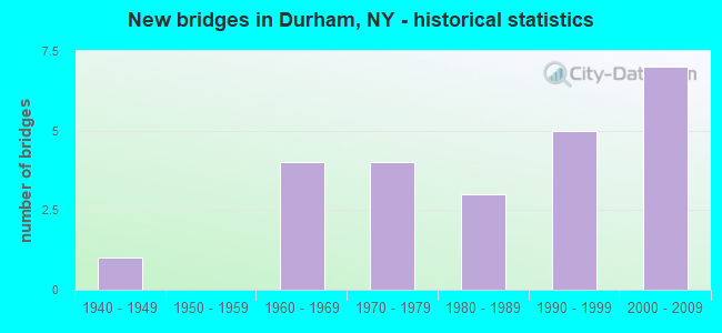
- New bridges - historical statistics
- 11940-1949
- 41960-1969
- 41970-1979
- 31980-1989
- 51990-1999
- 72000-2009
FCC Registered Antenna Towers:
4- Todd C Scaccia, 44 Mccafferty Road (Lat: 42.407083 Lon: -74.096167), Type: 36.6, Overall height: 36.6 m, Registrant: Wireless Applications Corporation, Fcc@wacorp.Net, , Belle-vue, Phone: (425) 643-5000
- Curtis L Miller, 44 Mccafferty Road (Lat: 42.407083 Lon: -74.096167), Type: 36.6, Overall height: 36.6 m, Registrant: Florida Tower Partners, LLC, Cmiller@tarpontowers.Com, , Brade-nton, Phone: (941) 757-5010
- Curtis L Miller, 44 Mccafferty Road (Lat: 42.407083 Lon: -74.096167), Type: 36.6, Overall height: 36.6 m, Registrant: Florida Tower Partners, LLC, Cmiller@tarpontowers.Com, , Brade-nton, Phone: (941) 757-5010
- Bridget Carter, 44 Mccafferty Road (Lat: 42.407083 Lon: -74.096167), Type: 36.6, Structure height: 36039 m, Overall height: 36.6 m, Registrant: Florida Tower Partners, LLC, Brade-nton, Phone: (941) 757-5010
FCC Registered Broadcast Land Mobile Towers:
5- 7646 Route 23 (Lat: 42.338944 Lon: -74.154167), Type: Tower, Structure height: 25 m, Call Sign: KNFA338,
Assigned Frequencies: 39.5800 MHz, Grant Date: 03/25/2022, Expiration Date: 03/12/2032, Registrant: County Of Albany, 449 New Salem Rd, Voorheesville, NY 12186, Phone: (518) 765-2352, Fax: (518) 765-5985, Email:
- Rt 145 (Lat: 42.400083 Lon: -74.164306), Call Sign: KXM671, Licensee ID: L00509361,
Assigned Frequencies: 47.6200 MHz, Grant Date: 05/01/2002, Expiration Date: 05/20/2012, Cancellation Date: 07/21/2012, Registrant: Cairo Durham Central School District, Cairo, NY 12413, Phone: (518) 622-2236
- 7646 Route 23 (Lat: 42.338944 Lon: -74.154167), Type: Gtower, Structure height: 25 m, Call Sign: WNAA609,
Assigned Frequencies: 154.415 MHz, Grant Date: 11/29/2023, Expiration Date: 12/10/2033, Certifier: Mark P Stevens, Registrant: Albany County Sheriff\'s Office, 449 New Salem Rd, Voorheesville, NY 12186, Phone: (518) 765-2352, Fax: (518) 765-5985, Email:
- 7646 Route 23 (Lat: 42.338944 Lon: -74.154167), Type: Tower, Structure height: 25 m, Call Sign: WPYS602,
Assigned Frequencies: 159.097 MHz, Grant Date: 07/30/2013, Expiration Date: 10/15/2023, Cancellation Date: 01/20/2024, Certifier: Mark P Stevens, Registrant: Albany County Sheriff\'s Office, 449 New Salem Rd, Voorheesville, NY 12186, Phone: (518) 765-2352, Fax: (518) 765-5985, Email:
- DURHAM, Off Allen Teator Road (Lat: 42.399056 Lon: -74.228667), Type: Ltower, Structure height: 45.7 m, Overall height: 47.2 m, Call Sign: WRAL517,
Assigned Frequencies: 155.895 MHz, Grant Date: 12/26/2017, Expiration Date: 12/26/2027, Certifier: John P Farrell Jr., Registrant: Communications Design Consulting Group, 9 Tibbetts Road, Barrington, NH 03825, Phone: (603) 905-9406, Email:
FCC Registered Amateur Radio Licenses:
1- Call Sign: WA2YGH, Licensee ID: L00944230, Grant Date: 06/16/2005, Expiration Date: 06/16/2015, Cancellation Date: 06/17/2017, Registrant: Dominick Saldamarco, 4086 State Route 145, Durham, NY 12422
FAA Registered Aircraft:
2- Aircraft: CESSNA 310Q (Category: Land, Engines: 2, Seats: 6, Weight: Up to 12,499 Pounds, Speed: 167 mph), Engine: CONT MOTOR I0-470 SERIES (260 HP) (Reciprocating)
N-Number: 7644Q, N7644Q, N-7644Q, Serial Number: 310Q0423, Year manufactured: 1971, Airworthiness Date: 12/08/1971, Certificate Issue Date: 07/09/2015
Registrant (Individual): Carl D Smith, 300 Allen Teator Rd, Durham, NY 12422 - Aircraft: BEECH 23 (Category: Land, Seats: 4, Weight: Up to 12,499 Pounds, Speed: 113 mph), Engine: LYCOMING 0-320 SERIES (180 HP) (Reciprocating)
N-Number: 8758M, N8758M, N-8758M, Serial Number: M-546, Year manufactured: 1964, Airworthiness Date: 05/06/1964, Certificate Issue Date: 06/04/2020
Registrant (Individual): Carl D Jr Smith, 300 Allen Teator Rd, Durham, NY 12422
| Most common first names in Durham, NY among deceased individuals | ||
| Name | Count | Lived (average) |
|---|---|---|
| John | 10 | 74.8 years |
| Charles | 6 | 63.9 years |
| Frank | 4 | 76.5 years |
| William | 4 | 72.7 years |
| Helen | 3 | 79.0 years |
| Margaret | 3 | 79.0 years |
| Martha | 3 | 67.6 years |
| Agnes | 2 | 73.5 years |
| Robert | 2 | 71.5 years |
| Alice | 2 | 88.6 years |
| Most common last names in Durham, NY among deceased individuals | ||
| Last name | Count | Lived (average) |
|---|---|---|
| Brink | 3 | 74.3 years |
| Morse | 3 | 80.3 years |
| Teator | 3 | 79.4 years |
| Vonschenk | 3 | 73.6 years |
| Fremgen | 2 | 74.1 years |
| Dobies | 2 | 85.0 years |
| King | 2 | 86.0 years |
| Gargan | 2 | 78.5 years |
| Hanafin | 2 | 76.5 years |
| German | 2 | 68.0 years |
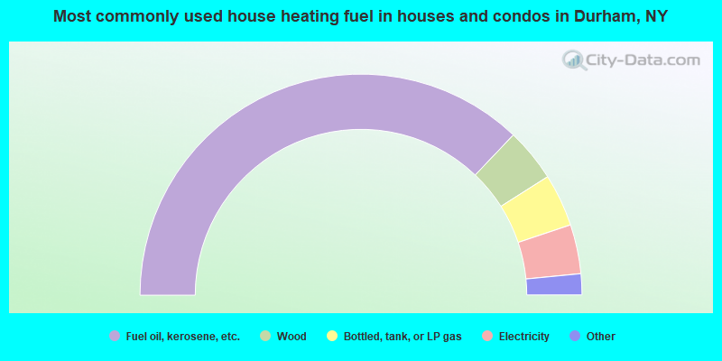
- 74.3%Fuel oil, kerosene, etc.
- 7.8%Wood
- 7.7%Bottled, tank, or LP gas
- 7.2%Electricity
- 1.4%Utility gas
- 0.6%Coal or coke
- 0.6%Other fuel
- 0.5%No fuel used
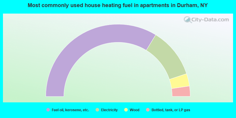
- 67.5%Fuel oil, kerosene, etc.
- 22.3%Electricity
- 5.6%Wood
- 4.6%Bottled, tank, or LP gas
Durham compared to New York state average:
- Median house value below state average.
- Black race population percentage significantly below state average.
- Hispanic race population percentage significantly below state average.
- Median age above state average.
- Foreign-born population percentage below state average.
- Renting percentage significantly below state average.
- Length of stay since moving in significantly above state average.
- Number of rooms per house significantly below state average.
- House age significantly below state average.
- Number of college students below state average.
- Percentage of population with a bachelor's degree or higher below state average.
Durham on our top lists:
- #51 on the list of "Top 101 cities with the largest percentage of people in other group homes (population 1,000+)"

|
Total of 1 patent application in 2008-2024.