Dilia, New Mexico
Submit your own pictures of this place and show them to the world
- OSM Map
- General Map
- Google Map
- MSN Map

| Males: 301 | |
| Females: 255 |
| Median resident age: | 40.2 years |
| New Mexico median age: | 34.6 years |
Zip code: 88435
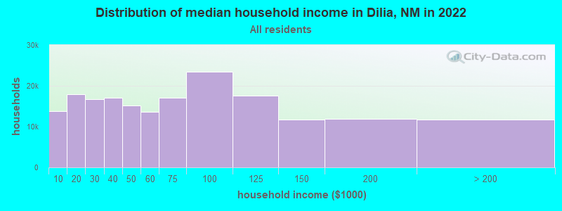
| Dilia: | $24,005 |
| NM: | $59,726 |
Estimated per capita income in 2022: $25,355 (it was $9,973 in 2000)
Dilia CCD income, earnings, and wages data
Estimated median house or condo value in 2022: $93,611 (it was $36,800 in 2000)
| Dilia: | $93,611 |
| NM: | $243,100 |
Mean prices in 2022: all housing units: $142,665; detached houses: $155,281; mobile homes: $140,836
Detailed information about poverty and poor residents in Dilia, NM


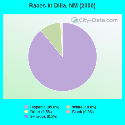
- 52689.0%Hispanic
- 5910.0%White alone
- 30.5%Other race alone
- 20.3%Black alone
- 10.2%Two or more races
Races in Dilia detailed stats: ancestries, foreign born residents, place of birth
 Recent articles from our blog. Our writers, many of them Ph.D. graduates or candidates, create easy-to-read articles on a wide variety of topics.
Current Local Time: MST time zone
Elevation: 5218 feet
Land area: 406.4 square miles.
Population density: 1.4 people per square mile (very low).

| Dilia CCD: | 0.5% ($199) |
| New Mexico: | 0.7% ($699) |
Nearest city with pop. 50,000+: Santa Fe, NM  (63.5 miles , pop. 62,203).
Nearest city with pop. 200,000+: Albuquerque, NM (87.4 miles , pop. 448,607).
Nearest city with pop. 1,000,000+: Phoenix, AZ (415.1 miles , pop. 1,321,045).
Nearest cities:
), )Latitude: 35.11 N, Longitude: 105.07 W
Area code commonly used in this area: 505

| Here: | 3.3% |
| New Mexico: | 3.6% |
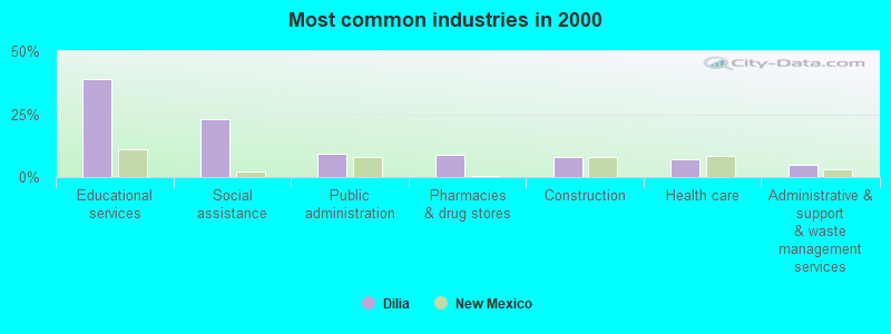
- Educational services (38.8%)
- Social assistance (23.0%)
- Public administration (9.4%)
- Pharmacies & drug stores (8.6%)
- Construction (7.9%)
- Health care (7.2%)
- Administrative & support & waste management services (5.0%)
- Educational services (33.3%)
- Pharmacies & drug stores (19.0%)
- Social assistance (19.0%)
- Construction (17.5%)
- Administrative & support & waste management services (11.1%)
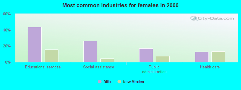
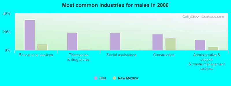
- Educational services (43.4%)
- Social assistance (26.3%)
- Public administration (17.1%)
- Health care (13.2%)
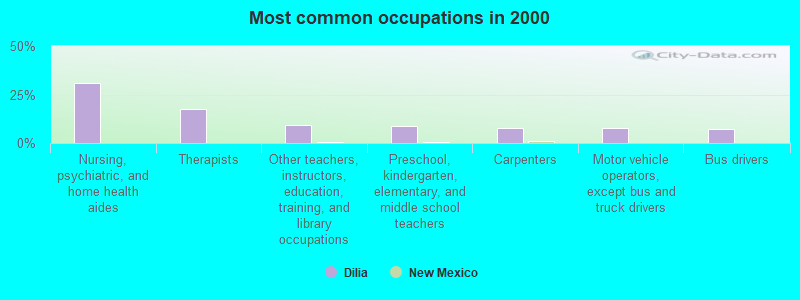
- Nursing, psychiatric, and home health aides (30.9%)
- Therapists (17.3%)
- Other teachers, instructors, education, training, and library occupations (9.4%)
- Preschool, kindergarten, elementary, and middle school teachers (8.6%)
- Carpenters (7.9%)
- Motor vehicle operators, except bus and truck drivers (7.9%)
- Bus drivers (7.2%)
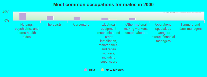
- Nursing, psychiatric, and home health aides (38.1%)
- Therapists (20.6%)
- Carpenters (17.5%)
- Electrical equipment mechanics and other installation, maintenance, and repair workers, including supervisors (12.7%)
- Other material moving workers, except laborers (11.1%)
- Operations specialties managers, except financial managers (0.0%)
- Farmers and farm managers (0.0%)
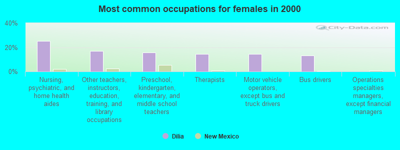
- Nursing, psychiatric, and home health aides (25.0%)
- Other teachers, instructors, education, training, and library occupations (17.1%)
- Preschool, kindergarten, elementary, and middle school teachers (15.8%)
- Therapists (14.5%)
- Motor vehicle operators, except bus and truck drivers (14.5%)
- Bus drivers (13.2%)
- Operations specialties managers, except financial managers (0.0%)
Average climate in Dilia, New Mexico
Based on data reported by over 4,000 weather stations


Earthquake activity:
Dilia-area historical earthquake activity is significantly above New Mexico state average. It is 553% greater than the overall U.S. average.On 8/23/2011 at 05:46:18, a magnitude 5.3 (5.3 MW, Depth: 2.5 mi, Class: Moderate, Intensity: VI - VII) earthquake occurred 136.3 miles away from Dilia center
On 8/10/2005 at 22:08:22, a magnitude 5.0 (5.0 MB, 4.7 MS, 5.0 MW) earthquake occurred 126.0 miles away from the city center
On 8/10/2005 at 22:08:22, a magnitude 5.0 (5.0 MW, Depth: 3.1 mi) earthquake occurred 127.4 miles away from Dilia center
On 1/29/1990 at 13:16:10, a magnitude 4.8 (4.5 MB, 4.8 LG, Depth: 7.5 mi, Class: Light, Intensity: IV - V) earthquake occurred 112.4 miles away from Dilia center
On 8/22/2011 at 23:30:19, a magnitude 4.7 (4.7 MW, Depth: 3.1 mi) earthquake occurred 135.7 miles away from the city center
On 4/14/1995 at 00:32:56, a magnitude 5.7 (5.6 MB, 5.7 MS, 5.7 MW, Depth: 11.1 mi) earthquake occurred 348.7 miles away from Dilia center
Magnitude types: regional Lg-wave magnitude (LG), body-wave magnitude (MB), surface-wave magnitude (MS), moment magnitude (MW)
Natural disasters:
The number of natural disasters in Guadalupe County (8) is smaller than the US average (15).Major Disasters (Presidential) Declared: 5
Emergencies Declared: 2
Causes of natural disasters: Floods: 3, Storms: 3, Fires: 2, Hurricane: 1, Mudslide: 1, Winter Storm: 1, Other: 1 (Note: some incidents may be assigned to more than one category).
Colleges/universities with over 2000 students nearest to Dilia:
- New Mexico Highlands University (about 35 miles; Las Vegas, NM; Full-time enrollment: 2,931)
- Santa Fe Community College (about 63 miles; Santa Fe, NM; FT enrollment: 3,047)
- University of Phoenix-Albuquerque Campus (about 87 miles; Albuquerque, NM; FT enrollment: 2,335)
- University of New Mexico-Main Campus (about 89 miles; Albuquerque, NM; FT enrollment: 23,042)
- Central New Mexico Community College (about 89 miles; Albuquerque, NM; FT enrollment: 19,398)
- Eastern New Mexico University-Main Campus (about 118 miles; Portales, NM; FT enrollment: 4,263)
- Eastern New Mexico University-Roswell Campus (about 129 miles; Roswell, NM; FT enrollment: 2,212)
Points of interest:
Notable locations in Dilia: Margarito Ulibarri Ranch (A), Marquez Ranch (B), Martinez Ranch (C), Miser Windmill (D), Moon Ranch (E), New Windmill (F), North Camp (G), North Windmill (H), P Ulibarri Ranch (I), Sanchez Ranch (J), Secundino Windmill (K), Sisneros Ranch (L), Sowell Ranch (M), Thompson Ranch (N), Alegre Windmill (O), Bibbs Ranch (P), Dahlia Pumping Station (Q), La Placita de Abajo Historic District (R), Hormigoso Irrigation Ditch and Dam (S), Colonias de San Jose Historic District (T). Display/hide their locations on the map
Church in Dilia: Sacred Heart Church (A). Display/hide its location on the map
Cemetery: Old Anton Chico Cemetery (1). Display/hide its location on the map
Lakes and reservoirs: Gibson Tank (A), Baker Lake (B), Laguna del Tuloso (C), Edwardo Lake (D), Bull Lake (E), Laguna del Tul (F), Remigio Tank (G), Punta de la Mesa (H). Display/hide their locations on the map
Streams, rivers, and creeks: Potrillo Creek (A), Spring Creek (B), Cañada Gomez (C), Cañada de Arriba (D), Cañada de Abajo (E), Agua de los Juanes (F), Cañada los Rincones (G). Display/hide their locations on the map
| This place: | 2.6 people |
| New Mexico: | 2.5 people |
| This place: | 62.4% |
| Whole state: | 65.5% |
| This place: | 11.2% |
| Whole state: | 8.2% |
Likely homosexual households (counted as self-reported same-sex unmarried-partner households)
- Lesbian couples: 0.4% of all households
- Gay men: 0.0% of all households
| This place: | 20.5% |
| Whole state: | 18.4% |
| This place: | 5.2% |
| Whole state: | 7.8% |
People in group quarters in Dilia in 2000:
- 9 people in nursing homes
- 7 people in homes for the mentally ill
- 6 people in other group homes
For population 15 years and over in Dilia:
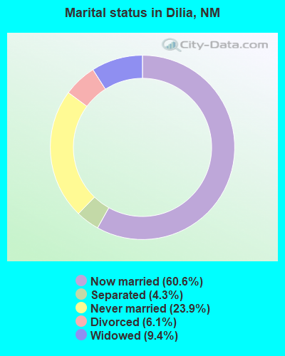
- Never married: 23.9%
- Now married: 60.6%
- Separated: 4.3%
- Widowed: 9.4%
- Divorced: 6.1%
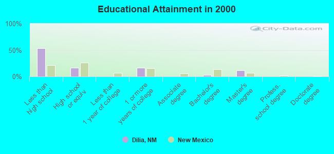
For population 25 years and over in Dilia:
- High school or higher: 46.3%
- Bachelor's degree or higher: 14.0%
- Graduate or professional degree: 11.2%
- Unemployed: 21.5%
- Mean travel time to work (commute): 47.4 minutes
| Here: | 21.6 |
| New Mexico average: | 14.5 |
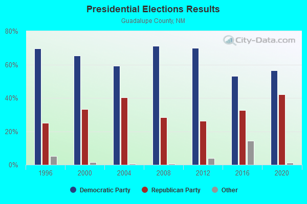
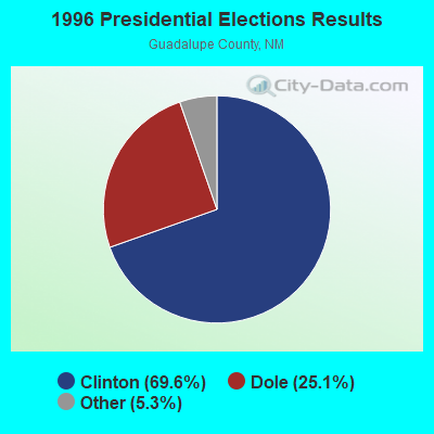
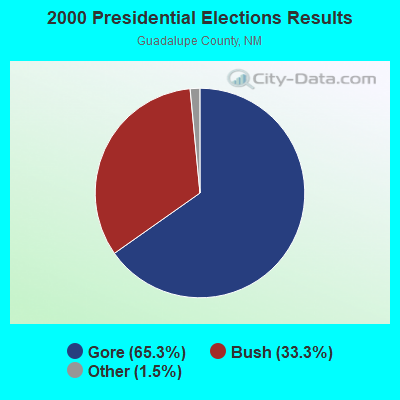
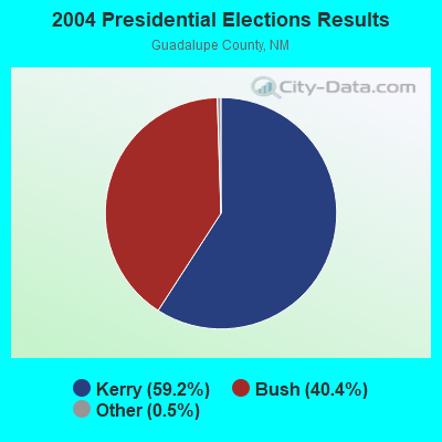
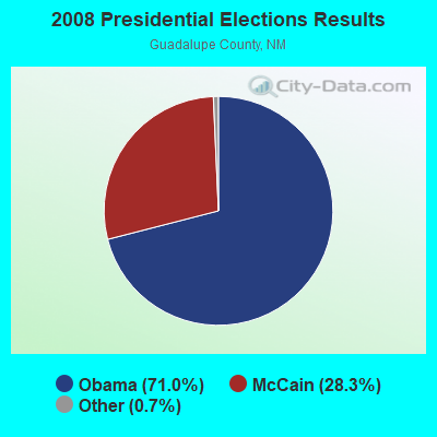
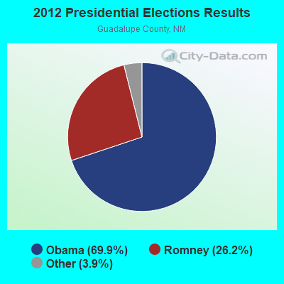
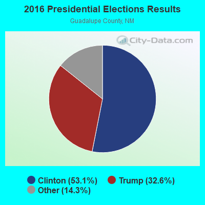
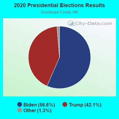
Graphs represent county-level data. Detailed 2008 Election Results
Religion statistics for Dilia, NM (based on Guadalupe County data)
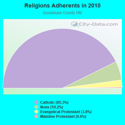
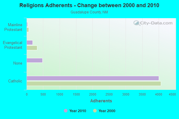
| Religion | Adherents | Congregations |
|---|---|---|
| Catholic | 4,000 | 13 |
| Evangelical Protestant | 180 | 4 |
| Mainline Protestant | 28 | 1 |
| Other | - | 1 |
| None | 479 | - |
Food Environment Statistics:
| Here: | 2.26 / 10,000 pop. |
| New Mexico: | 1.44 / 10,000 pop. |
| This county: | 18.12 / 10,000 pop. |
| New Mexico: | 4.06 / 10,000 pop. |
| Here: | 18.12 / 10,000 pop. |
| New Mexico: | 7.12 / 10,000 pop. |
| This county: | 5.8% |
| State: | 6.4% |
| Guadalupe County: | 21.9% |
| State: | 22.1% |
| Guadalupe County: | 9.2% |
| New Mexico: | 11.5% |
Strongest AM radio stations in Dilia:
- KKOB (770 AM; 50 kW; ALBUQUERQUE, NM; Owner: CITADEL BROADCASTING COMPANY)
- KNMX (540 AM; 5 kW; LAS VEGAS, NM; Owner: SANGRE DE CRISTO B/DCASTING CO, INC)
- KICA (980 AM; 50 kW; CLOVIS, NM; Owner: BROADCAST ENTERTAINMENT CORPORATION)
- KINF (1020 AM; 50 kW; ROSWELL, NM; Owner: JAMES CRYSTAL HOLDINGS OF NEW MEXICO, INC.)
- KMUL (1380 AM; 50 kW; MULESHOE, TX; Owner: BROADCAST ENTERTAINMENT CORPORATION)
- KSWV (810 AM; 5 kW; SANTA FE, NM; Owner: LA VOZ BROADCASTING CO., INC.)
- KTNN (660 AM; 50 kW; WINDOW ROCK, AZ; Owner: THE NAVAJO NATION)
- KKIM (1000 AM; 10 kW; ALBUQUERQUE, NM; Owner: AGM-NEVADA, LLC)
- KSSR (1340 AM; 1 kW; SANTA ROSA, NM; Owner: J. MICHAEL ESQUIBEL)
- KXKS (1190 AM; 10 kW; ALBUQUERQUE, NM; Owner: CLEAR CHANNEL BROADCASTING LICENSES, INC.)
- KTRC (1260 AM; 5 kW; SANTA FE, NM; Owner: AGM NEVADA, LLC)
- KHAC (880 AM; 43 kW; TSE BONITO, NM; Owner: WESTERN INDIAN MINISTRIES, INC.)
- KNML (610 AM; 5 kW; ALBUQUERQUE, NM; Owner: CITADEL BROADCASTING COMPANY)
Strongest FM radio stations in Dilia:
- KLSK (98.1 FM; LAS VEGAS, NM; Owner: CLEAR CHANNEL BROADCASTING LICENSES, INC.)
- KTZO (103.3 FM; ALBUQUERQUE, NM; Owner: CITADEL BROADCASTING COMPANY)
- KLYT (88.3 FM; ALBUQUERQUE, NM; Owner: CONNECTION COMMUNICATIONS ASSOCIATION, INC.)
- KUNM (89.9 FM; ALBUQUERQUE, NM; Owner: BOARD OF REGENTS UNIV. OF NEW MEXICO)
- KANW (89.1 FM; ALBUQUERQUE, NM; Owner: BD. OF EDUC. CITY OF ALBUQUERQUE, NM)
- KRST (92.3 FM; ALBUQUERQUE, NM; Owner: CITADEL BROADCASTING COMPANY)
- KKOB-FM (93.3 FM; ALBUQUERQUE, NM; Owner: CITADEL BROADCASTING COMPANY)
- KBZU (96.3 FM; ALBUQUERQUE, NM; Owner: CITADEL BROADCASTING COMPANY)
- KBQI (107.9 FM; ALBUQUERQUE, NM; Owner: CITICASTERS LICENSES, L.P.)
- KMGA (99.5 FM; ALBUQUERQUE, NM; Owner: CITADEL BROADCASTING COMPANY)
- KZRR (94.1 FM; ALBUQUERQUE, NM; Owner: CLEAR CHANNEL BROADCASTING LICENSES, INC.)
- KPEK (100.3 FM; ALBUQUERQUE, NM; Owner: CITICASTERS LICENSES, L.P.)
- KFLQ (91.5 FM; ALBUQUERQUE, NM; Owner: FAMILY LIFE BROADCASTING SYSTEM)
- K265CA (100.9 FM; ALBUQUERQUE, NM; Owner: CITICASTERS LICENSES, L.P.)
- K213BT (90.5 FM; ALBUQUERQUE, NM; Owner: EDUCATIONAL MEDIA FOUNDATION)
- K215DT (90.9 FM; SAN AUGUSTIN, NM; Owner: EASTERN NEW MEXICO UNIVERSITY)
- National Bridge Inventory (NBI) Statistics
- 1Number of bridges
- 33ft / 9.6mTotal length
- 1,501Total average daily traffic
- 555Total average daily truck traffic
- 2,569Total future (year 2040) average daily traffic
FCC Registered Cell Phone Towers:
1- 4960 N. Us Hwy 84 (169622) (Lat: 35.209639 Lon: -105.079833), Type: Gtower, Structure height: 55.2 m, Overall height: 57.3 m, Call Sign: KNKN598
Assigned Frequencies: 880.020 MHz, 880.020 MHz, 880.020 MHz, 835.020 MHz, 835.020 MHz, 835.020 MHz, 891.510 MHz, 891.510 MHz, 891.510 MHz, 846.510 MHz, 846.510 MHz, 846.510 MHzGrant Date: 10/08/2019, Expiration Date: 10/01/2029, Certifier: Michael P GogginRegistrant: At&t Services, Inc., 208 S Akard St, 20f, Dallas, TX 75202, Phone: (855) 699-7073, Fax: (214) 746-6410, Email:
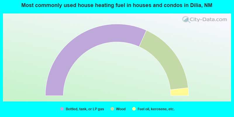
- 63.5%Bottled, tank, or LP gas
- 33.0%Wood
- 3.5%Fuel oil, kerosene, etc.
Dilia compared to New Mexico state average:
- Median household income significantly below state average.
- Median house value significantly below state average.
- Black race population percentage significantly below state average.
- Hispanic race population percentage above state average.
- Foreign-born population percentage significantly below state average.
- Renting percentage below state average.
- Length of stay since moving in significantly above state average.
- Number of rooms per house significantly below state average.
- House age significantly below state average.