Dewitt, Kentucky
Submit your own pictures of this place and show them to the world
- OSM Map
- General Map
- Google Map
- MSN Map

| Males: 1,042 | |
| Females: 1,065 |
| Median resident age: | 32.2 years |
| Kentucky median age: | 35.9 years |
Zip code: 40982
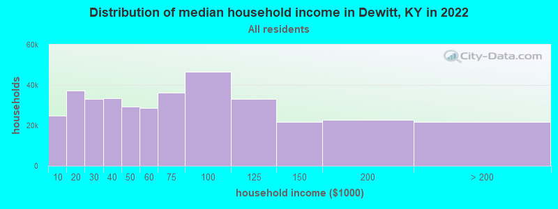
| Dewitt: | $25,218 |
| KY: | $59,341 |
Estimated per capita income in 2022: $13,142 (it was $6,689 in 2000)
Dewitt CCD income, earnings, and wages data
Estimated median house or condo value in 2022: $61,250 (it was $22,000 in 2000)
| Dewitt: | $61,250 |
| KY: | $196,300 |
Detailed information about poverty and poor residents in Dewitt, KY
Compare current foreclosures near Dewitt, KY:
| Photo | Address | Area | Beds / Baths | Price | Details |
|---|---|---|---|---|---|

|
#1
Edgewood Dr
Barbourville, KY 40906
|
2,104 sq. feet
|
3 baths 4 beds |
show details | |

|
#2
Kay Jay Camp Rd
Barbourville, KY 40906
|
700 sq. feet
|
1 baths 2 beds |
show details | |

|
#3
John Bailey Rd
Arjay, KY 40902
|
- sq. feet
|
- baths - beds |
$17,900
|
show details |

|
#4
Add Hollow Rd
Manchester, KY 40962
|
1,690 sq. feet
|
2 baths 4 beds |
show details | |

|
#5
Big Brush Church Creek Rd
Trosper, KY 40995
|
- sq. feet
|
- baths - beds |
$11,900
|
show details |

|
#6
Bee Quick Ln
Gray, KY 40734
|
1,408 sq. feet
|
1 baths 3 beds |
show details | |

|
#7
S Highway 11
Manchester, KY 40962
|
1,416 sq. feet
|
1 baths 3 beds |
show details | |

|
#8
E Laurel Rd
London, KY 40741
|
2,290 sq. feet
|
2 baths 3 beds |
show details | |

|
#9
Highway 1524
Manchester, KY 40962
|
1,188 sq. feet
|
1 baths 3 beds |
show details | |

|
#10
Elisha Feltner Rd
London, KY 40744
|
1,368 sq. feet
|
2 baths 3 beds |
show details |
| Photo | Address | Area | Beds / Baths | Price | Details |
|---|---|---|---|---|---|

|
#11
Paces Creek Cemetery Rd
Manchester, KY 40962
|
1,140 sq. feet
|
2 baths 3 beds |
show details | |

|
#12
Rockhouse Branch Rd
Manchester, KY 40962
|
1,209 sq. feet
|
2 baths 3 beds |
show details | |

|
#13
Hacker Ln
Manchester, KY 40962
|
1,134 sq. feet
|
1 baths 3 beds |
show details | |

|
#14
Pawpaw Rd
Manchester, KY 40962
|
1,080 sq. feet
|
1 baths 3 beds |
show details | |

|
#15
Dogwood Trl
Pineville, KY 40977
|
2,255 sq. feet
|
3 baths - beds |
show details | |

|
#16
Mcfadden Cemetery Rd
London, KY 40744
|
1,500 sq. feet
|
1 baths - beds |
show details | |

|
#17
Williams Branch Right Fork Rd
Pineville, KY 40977
|
1,056 sq. feet
|
1 baths - beds |
show details | |

|
#18
Orleans Ct
Gray, KY 40734
|
- sq. feet
|
- baths - beds |
show details | |

|
#19
E Laurel Rd
London, KY 40741
|
- sq. feet
|
- baths - beds |
show details | |

|
#20
Lancewood Dr
Gray, KY 40734
|
- sq. feet
|
- baths - beds |
show details |
| Photo | Address | Area | Beds / Baths | Price | Details |
|---|---|---|---|---|---|

|
#21
Allen Ln
Hulen, KY 40845
|
- sq. feet
|
- baths - beds |
show details | |

|
#22
Highway 72
Hulen, KY 40845
|
- sq. feet
|
- baths - beds |
show details | |

|
#23
Warren Camp Rd
Barbourville, KY 40906
|
- sq. feet
|
- baths - beds |
show details | |

|
#24
Ky 6
Barbourville, KY 40906
|
- sq. feet
|
- baths - beds |
show details | |

|
#25
Catfish Hollow Rd
Manchester, KY 40962
|
- sq. feet
|
- baths - beds |
show details | |

|
#26
Little Creek Rd
Big Creek, KY 40914
|
980 sq. feet
|
- baths - beds |
show details | |

|
#27
Crawfish Rd
Manchester, KY 40962
|
- sq. feet
|
- baths - beds |
show details | |

|
#28
Bull Run Rd
Barbourville, KY 40906
|
- sq. feet
|
- baths - beds |
show details | |

|
#29
S Ky 233
Gray, KY 40734
|
- sq. feet
|
- baths - beds |
show details | |

|
#30
S Highway 11
Manchester, KY 40962
|
- sq. feet
|
- baths - beds |
show details |
| Photo | Address | Area | Beds / Baths | Price | Details |
|---|---|---|---|---|---|

|
#31
Dorcas Jane Ln
Wallins Creek, KY 40873
|
- sq. feet
|
- baths - beds |
show details | |

|
#32
S Highway 66
Big Creek, KY 40914
|
- sq. feet
|
- baths - beds |
show details | |

|
#33
Sam Parker Rd
Gray, KY 40734
|
- sq. feet
|
- baths - beds |
show details | |

|
#34
Barbourville Rd
London, KY 40744
|
- sq. feet
|
- baths - beds |
show details | |

|
#35
Ham Hollow Rd # 7
Manchester, KY 40962
|
- sq. feet
|
- baths - beds |
show details | |

|
#36
Katrina Ridge Rd
Bryants Store, KY 40921
|
- sq. feet
|
- baths - beds |
show details | |

|
#37
Ham Hollow Rd
Manchester, KY 40962
|
- sq. feet
|
- baths - beds |
show details | |

|
#38
Blue Diamond Camp Rd
Pathfork, KY 40863
|
- sq. feet
|
- baths - beds |
show details | |

|
#39
Yellow Bird Ln
Gray, KY 40734
|
- sq. feet
|
- baths - beds |
show details | |

|
#40
Cedar St
Pineville, KY 40977
|
1,512 sq. feet
|
- baths - beds |
show details |
| Photo | Address | Area | Beds / Baths | Price | Details |
|---|---|---|---|---|---|

|
#41
G And A Ln
Hinkle, KY 40953
|
- sq. feet
|
- baths - beds |
show details | |

|
#42
Ky 1304
Hinkle, KY 40953
|
- sq. feet
|
- baths - beds |
show details | |

|
#43
Progress Rd
Bimble, KY 40915
|
- sq. feet
|
- baths - beds |
show details | |

|
#44
Fairview Trl
Bimble, KY 40915
|
- sq. feet
|
- baths - beds |
show details | |

|
#45
Ramsey Branch Rd
Artemus, KY 40903
|
- sq. feet
|
- baths - beds |
show details | |

|
#46
Mill Creek Rd
Kettle Island, KY 40958
|
- sq. feet
|
- baths - beds |
show details | |

|
#47
Mcgaffie Loop
Pineville, KY 40977
|
- sq. feet
|
- baths - beds |
show details | |

|
#48
Rose Rd
Pineville, KY 40977
|
- sq. feet
|
- baths - beds |
show details | |

|
#49
S Ky 3438
Cannon, KY 40923
|
- sq. feet
|
- baths - beds |
show details | |

|
Check over 1 million property listings on Foreclosure.com!
|
browse all offers | |||

- 2,05498.8%White alone
- 130.6%Two or more races
- 110.5%Hispanic
- 10.05%American Indian alone
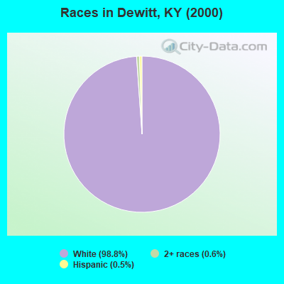
Races in Dewitt detailed stats: ancestries, foreign born residents, place of birth
 Recent articles from our blog. Our writers, many of them Ph.D. graduates or candidates, create easy-to-read articles on a wide variety of topics.
Current Local Time: EST time zone
Land area: 79.9 square miles.
Population density: 26 people per square mile (very low).

| Dewitt CCD: | 1.0% ($217) |
| Kentucky: | 0.8% ($610) |
Nearest city with pop. 50,000+: Knoxville, TN  (66.4 miles , pop. 173,890).
Nearest city with pop. 200,000+: Fayette, KY (88.8 miles , pop. 260,512).
Nearest city with pop. 1,000,000+: Chicago, IL (401.7 miles , pop. 2,896,016).
Nearest cities:
), ), ), ), ), )Latitude: 36.91 N, Longitude: 83.70 W
Area code commonly used in this area: 606

| Here: | 5.4% |
| Kentucky: | 3.8% |
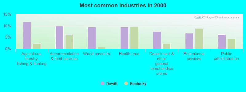
- Agriculture, forestry, fishing & hunting (11.7%)
- Accommodation & food services (9.9%)
- Wood products (9.4%)
- Health care (9.4%)
- Department & other general merchandise stores (7.5%)
- Educational services (6.7%)
- Public administration (6.3%)
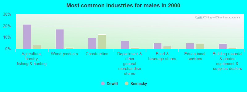
- Agriculture, forestry, fishing & hunting (21.3%)
- Wood products (17.1%)
- Construction (9.5%)
- Department & other general merchandise stores (6.8%)
- Food & beverage stores (4.9%)
- Educational services (4.9%)
- Building material & garden equipment & supplies dealers (4.6%)
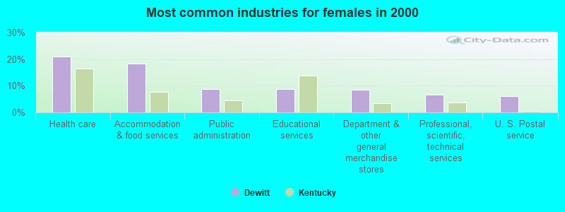
- Health care (21.0%)
- Accommodation & food services (18.2%)
- Public administration (8.9%)
- Educational services (8.9%)
- Department & other general merchandise stores (8.4%)
- Professional, scientific, technical services (6.5%)
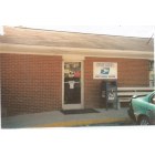
- U. S. Postal service (6.1%)
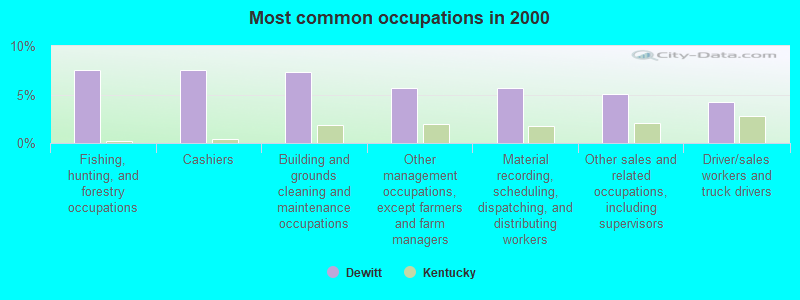
- Fishing, hunting, and forestry occupations (7.5%)
- Cashiers (7.5%)
- Building and grounds cleaning and maintenance occupations (7.3%)
- Other management occupations, except farmers and farm managers (5.7%)
- Material recording, scheduling, dispatching, and distributing workers (5.7%)
- Other sales and related occupations, including supervisors (5.0%)
- Driver/sales workers and truck drivers (4.2%)
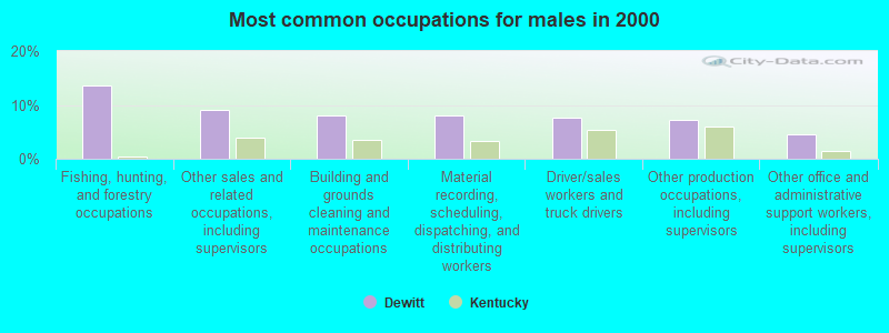
- Fishing, hunting, and forestry occupations (13.7%)
- Other sales and related occupations, including supervisors (9.1%)
- Building and grounds cleaning and maintenance occupations (8.0%)
- Material recording, scheduling, dispatching, and distributing workers (8.0%)
- Driver/sales workers and truck drivers (7.6%)
- Other production occupations, including supervisors (7.2%)
- Other office and administrative support workers, including supervisors (4.6%)
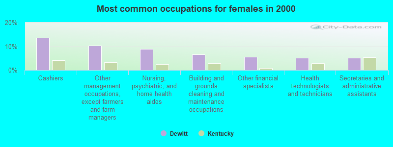
- Cashiers (13.6%)
- Other management occupations, except farmers and farm managers (10.3%)
- Nursing, psychiatric, and home health aides (8.9%)
- Building and grounds cleaning and maintenance occupations (6.5%)
- Other financial specialists (5.6%)
- Health technologists and technicians (5.1%)
- Secretaries and administrative assistants (5.1%)
Average climate in Dewitt, Kentucky
Based on data reported by over 4,000 weather stations


(lower is better)
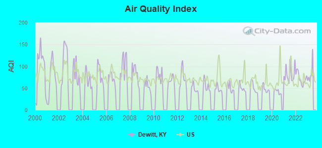
Air Quality Index (AQI) level in 2022 was 72.3. This is about average.
| City: | 72.3 |
| U.S.: | 72.6 |
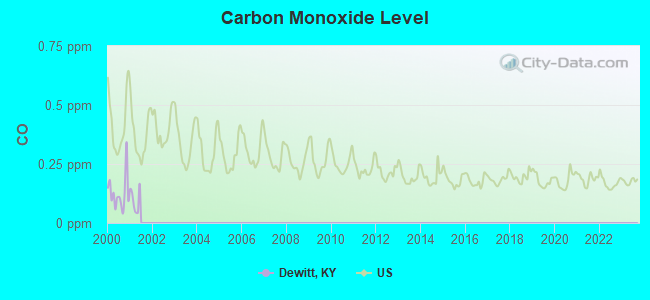
Carbon Monoxide (CO) [ppm] level in 2000 was 0.127. This is significantly better than average. Closest monitor was 21.0 miles away from the city center.
| City: | 0.127 |
| U.S.: | 0.251 |
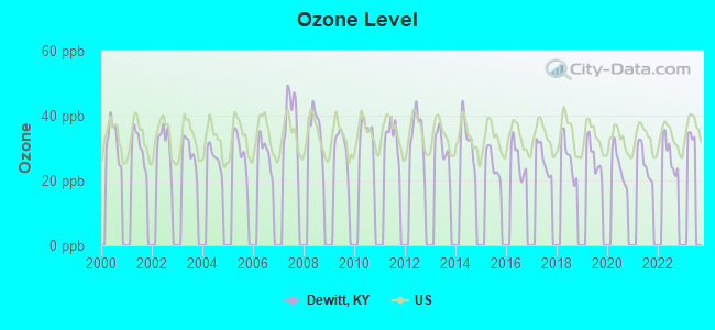
Ozone [ppb] level in 2022 was 27.8. This is about average. Closest monitor was 19.0 miles away from the city center.
| City: | 27.8 |
| U.S.: | 33.3 |
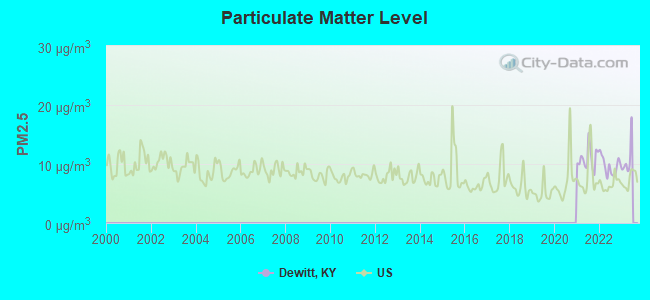
Particulate Matter (PM2.5) [µg/m3] level in 2022 was 9.68. This is about average. Closest monitor was 21.1 miles away from the city center.
| City: | 9.68 |
| U.S.: | 8.11 |
Tornado activity:
Dewitt-area historical tornado activity is significantly below Kentucky state average. It is 40% smaller than the overall U.S. average.
On 5/9/1988, a category F3 (max. wind speeds 158-206 mph) tornado 21.8 miles away from the Dewitt place center killed one person and injured 15 people and caused between $5,000,000 and $50,000,000 in damages.
On 6/29/1973, a category F3 tornado 25.9 miles away from the place center injured 2 people and caused between $50,000 and $500,000 in damages.
Earthquake activity:
Dewitt-area historical earthquake activity is significantly above Kentucky state average. It is 62% greater than the overall U.S. average.On 7/27/1980 at 18:52:21, a magnitude 5.2 (5.1 MB, 4.7 MS, 5.0 UK, 5.2 UK, Class: Moderate, Intensity: VI - VII) earthquake occurred 90.4 miles away from the city center
On 8/9/2020 at 12:07:37, a magnitude 5.1 (5.1 MW, Depth: 4.7 mi) earthquake occurred 147.7 miles away from the city center
On 11/30/1973 at 07:48:41, a magnitude 4.7 (4.7 MB, 4.6 ML, Class: Light, Intensity: IV - V) earthquake occurred 78.4 miles away from the city center
On 9/7/1988 at 02:28:09, a magnitude 4.6 (4.5 MB, 4.6 LG) earthquake occurred 85.7 miles away from Dewitt center
On 8/23/2011 at 17:51:04, a magnitude 5.8 (5.8 MW, Depth: 3.7 mi) earthquake occurred 324.0 miles away from the city center
On 4/18/2008 at 09:36:59, a magnitude 5.4 (5.1 MB, 4.8 MS, 5.4 MW, 5.2 MW) earthquake occurred 252.7 miles away from Dewitt center
Magnitude types: regional Lg-wave magnitude (LG), body-wave magnitude (MB), local magnitude (ML), surface-wave magnitude (MS), moment magnitude (MW)
Natural disasters:
The number of natural disasters in Knox County (31) is a lot greater than the US average (15).Major Disasters (Presidential) Declared: 24
Emergencies Declared: 2
Causes of natural disasters: Floods: 22, Storms: 19, Mudslides: 8, Tornadoes: 7, Landslides: 6, Winter Storms: 5, Fires: 2, Snows: 2, Snowstorms: 2, Winds: 2, Blizzard: 1, Freeze: 1, Hurricane: 1, Snowfall: 1, Other: 1 (Note: some incidents may be assigned to more than one category).
Colleges/universities with over 2000 students nearest to Dewitt:
- Lincoln Memorial University (about 23 miles; Harrogate, TN; Full-time enrollment: 3,706)
- University of the Cumberlands (about 29 miles; Williamsburg, KY; FT enrollment: 3,585)
- Hazard Community and Technical College (about 37 miles; Hazard, KY; FT enrollment: 2,087)
- Southeast Kentucky Community and Technical College (about 40 miles; Cumberland, KY; FT enrollment: 2,196)
- Somerset Community College (about 52 miles; Somerset, KY; FT enrollment: 4,698)
- Walters State Community College (about 55 miles; Morristown, TN; FT enrollment: 4,359)
- Eastern Kentucky University (about 67 miles; Richmond, KY; FT enrollment: 13,525)
Points of interest:
Notable locations in Dewitt: Mills (A), Salt Gum (B), Barnyard (C), The Forks of Stinking (D), Stinking Creek Fire Department (E). Display/hide their locations on the map
Churches in Dewitt include: Jeff Creek Church (A), Salem Baptist Church (B), Mill Mission Church (C), Walker Church (D), Holiness Church (E), Fellowship Church (F), Young Grove Church (G), Salt Gum Church (H), Union Mission Church (I). Display/hide their locations on the map
Cemetery: Mills-Messer Cemetery (1). Display/hide its location on the map
Streams, rivers, and creeks: Burnt House Branch (A), Camel Branch (B), Carter Roark Branch (C), Coles Branch (D), Clark Branch (E), Hale Fork (F), Dora Branch (G), Henry Branch (H), Hinkle Branch (I). Display/hide their locations on the map
| This place: | 2.5 people |
| Kentucky: | 2.5 people |
| This place: | 69.5% |
| Whole state: | 66.9% |
| This place: | 3.0% |
| Whole state: | 6.4% |
Likely homosexual households (counted as self-reported same-sex unmarried-partner households)
- Lesbian couples: 0.4% of all households
- Gay men: 0.1% of all households
| This place: | 54.6% |
| Whole state: | 15.8% |
| This place: | 15.1% |
| Whole state: | 6.6% |
For population 15 years and over in Dewitt:
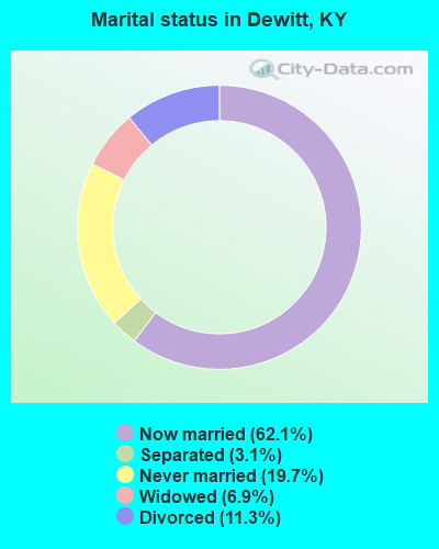
- Never married: 19.7%
- Now married: 62.1%
- Separated: 3.1%
- Widowed: 6.9%
- Divorced: 11.3%
For population 25 years and over in Dewitt:
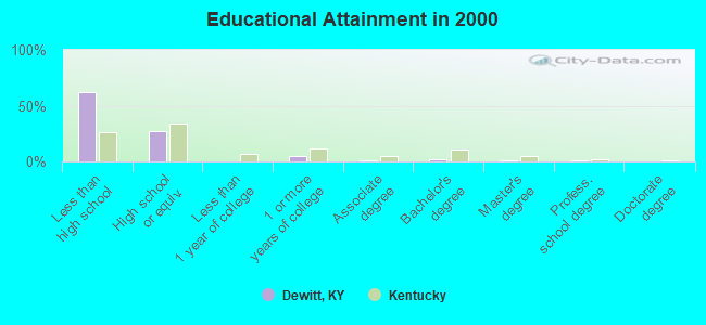
- High school or higher: 37.4%
- Bachelor's degree or higher: 3.9%
- Graduate or professional degree: 2.2%
- Unemployed: 9.1%
- Mean travel time to work (commute): 35.0 minutes
| Here: | 22.1 |
| Kentucky average: | 13.8 |
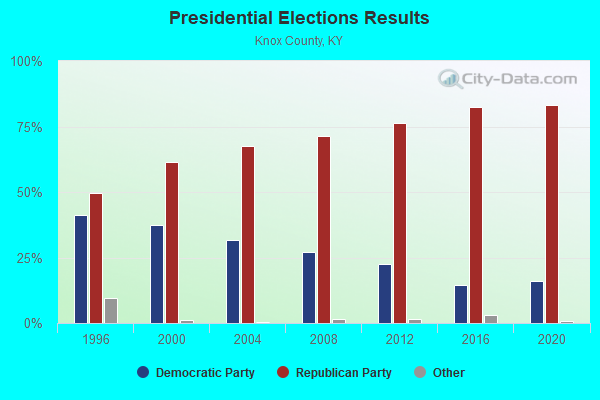
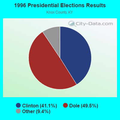
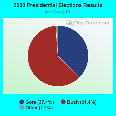
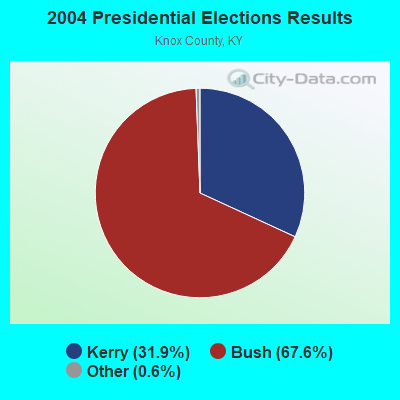
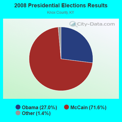
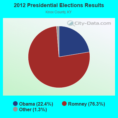
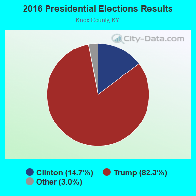
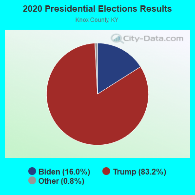
Graphs represent county-level data. Detailed 2008 Election Results
Religion statistics for Dewitt, KY (based on Knox County data)
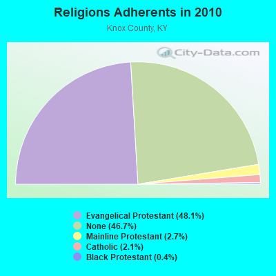
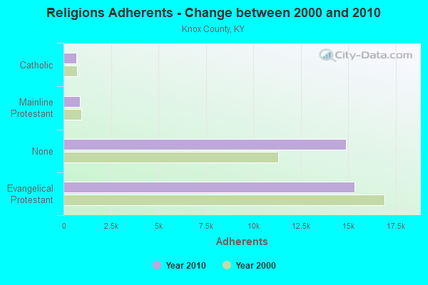
| Religion | Adherents | Congregations |
|---|---|---|
| Evangelical Protestant | 15,334 | 56 |
| Mainline Protestant | 859 | 5 |
| Catholic | 678 | 2 |
| Black Protestant | 123 | 1 |
| Other | - | 1 |
| None | 14,889 | - |
Food Environment Statistics:
| Here: | 2.77 / 10,000 pop. |
| Kentucky: | 2.19 / 10,000 pop. |
| This county: | 0.31 / 10,000 pop. |
| State: | 0.74 / 10,000 pop. |
| Knox County: | 3.38 / 10,000 pop. |
| Kentucky: | 4.36 / 10,000 pop. |
| Here: | 3.38 / 10,000 pop. |
| State: | 5.74 / 10,000 pop. |
| Knox County: | 11.6% |
| Kentucky: | 11.0% |
| This county: | 32.3% |
| Kentucky: | 30.0% |
| Here: | 21.0% |
| State: | 15.9% |
Strongest AM radio stations in Dewitt:
- WKVL (850 AM; daytime; 50 kW; KNOXVILLE, TN; Owner: HORNE RADIO, LLC)
- WKLB (1290 AM; 5 kW; MANCHESTER, KY; Owner: BARKER BROADCASTING COMPANY, INC.)
- WHLN (1410 AM; 5 kW; HARLAN, KY)
- WFSR (970 AM; 5 kW; HARLAN, KY; Owner: EASTERN BROADCASTING COMPAY)
- WMIK (560 AM; 2 kW; MIDDLESBORO, KY; Owner: GATEWAY BROADCASTING, INC.)
- WYWY (950 AM; 1 kW; BARBOURVILLE, KY; Owner: BARBOURVILLE-COMMNITY BROADC/G CO IN)
- WKDP (1330 AM; 5 kW; CORBIN, KY; Owner: EUBANKS BROADCASTING, INC.)
- WANO (1230 AM; 1 kW; PINEVILLE, KY; Owner: CUMBERLAND MEDIA GROUP, INC.)
- WEKC (710 AM; daytime; 4 kW; WILLIAMSBURG, KY; Owner: GERALD PARKS)
- WFGW (1010 AM; 50 kW; BLACK MOUNTAIN, NC; Owner: BLUE RIDGE BROADCASTING CORP.)
- WHAS (840 AM; 50 kW; LOUISVILLE, KY; Owner: CLEAR CHANNEL BROADCASTING LICENSES, INC.)
- WKIC (1390 AM; 5 kW; HAZARD, KY)
- WLFJ (660 AM; daytime; 50 kW; GREENVILLE, SC; Owner: CLEAR CHANNEL BROADCASTING LICENSES, INC.)
Strongest FM radio stations in Dewitt:
- WRIL (106.3 FM; PINEVILLE, KY; Owner: PINE HILLS BROADCASTING, INC.)
- WMIK-FM (92.7 FM; MIDDLESBORO, KY; Owner: GATEWAY BROADCASTING, INC.)
- WKDP-FM (99.5 FM; CORBIN, KY; Owner: EUBANKS BROADCASTING, INC.)
- WWLT (103.1 FM; MANCHESTER, KY; Owner: VERNON R. BALDWIN, INC.)
- WTUK (105.1 FM; HARLAN, KY; Owner: EASTERN BROADCASTING COMPANY)
- WSEH (102.7 FM; CUMBERLAND, KY; Owner: CUMBERLAND CITY BROADCASTING, INC.)
- WSGS (101.1 FM; HAZARD, KY; Owner: MOUNTAIN BROADCASTING SERVICE, INC.)
- WKKQ (96.1 FM; BARBOURVILLE, KY; Owner: BARBOURVILLE COMMUNITY B/NG CO.INC.)
- WAXM (93.5 FM; BIG STONE GAP, VA; Owner: VALLEY BROADCASTING, INC.)
- WCTU (105.9 FM; TAZEWELL, TN; Owner: STAIR COMPANY, INC)
- WTBK (105.7 FM; MANCHESTER, KY; Owner: MANCHESTER COMMUNICATIONS, INC.)
- WEKX (102.7 FM; JELLICO, TN; Owner: WHITLEY BROADCASTING CO., INC.)
- WZQQ (97.9 FM; HYDEN, KY; Owner: LESLIE COUNTY BROADCASTING, INC.)
- WEKH (90.9 FM; HAZARD, KY; Owner: EASTERN KENTUCKY UNIVERSITY)
- WJMD (104.7 FM; HAZARD, KY; Owner: HAZARD BROADCASTING SERVICES)
- WDVX (89.9 FM; CLINTON, TN; Owner: CUMBERLAND COMMUNITIES COMMUNI CORP.)
- WIMZ-FM (103.5 FM; KNOXVILLE, TN; Owner: SOUTH CENTRAL COMM., CORP.)
- WCTT-FM (107.3 FM; CORBIN, KY; Owner: ENCORE COMMUNICATIONS, INC.)
- WJDT (106.5 FM; ROGERSVILLE, TN; Owner: C & S BROADCASTING)
- WYGE (92.3 FM; LONDON, KY; Owner: ETHEL HUFF BROADCASTING, LLC)
TV broadcast stations around Dewitt:
- WAGV (Channel 44; HARLAN, KY; Owner: LIVING FAITH MINISTRIES, INC.)
- WYMT-TV (Channel 57; HAZARD, KY; Owner: WYMT LICENSEE CORP.)
- W26BK (Channel 26; TALBERT, KY; Owner: MS COMMUNICATIONS, LLC)
- W24BT (Channel 24; TALBERT, KY; Owner: MS COMMUNICATIONS, LLC)
- W33BK (Channel 33; CORBIN, KY; Owner: TRINITY BROADCASTING NETWORK)
- WVTN-LP (Channel 48; CORBIN, KY; Owner: VICTORY TRAINING SCHOOL CORP.)
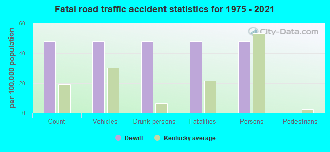
Dewitt fatal accident list:
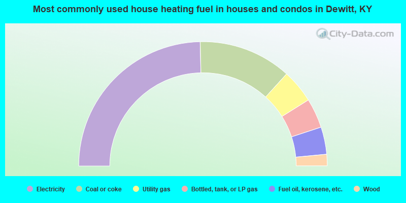
- 49.3%Electricity
- 24.2%Coal or coke
- 8.7%Utility gas
- 7.7%Bottled, tank, or LP gas
- 7.1%Fuel oil, kerosene, etc.
- 3.0%Wood
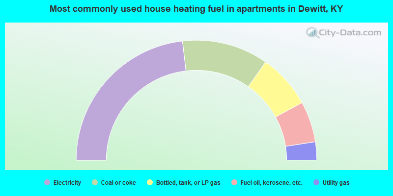
- 46.3%Electricity
- 23.2%Coal or coke
- 14.6%Bottled, tank, or LP gas
- 11.0%Fuel oil, kerosene, etc.
- 4.9%Utility gas
Dewitt compared to Kentucky state average:
- Median household income significantly below state average.
- Median house value significantly below state average.
- Black race population percentage significantly below state average.
- Hispanic race population percentage significantly below state average.
- Median age significantly below state average.
- Foreign-born population percentage significantly below state average.
- Length of stay since moving in significantly above state average.
- Number of rooms per house significantly below state average.
- House age significantly below state average.
- Number of college students below state average.
- Percentage of population with a bachelor's degree or higher significantly below state average.