Dennistown plantation, Maine
Submit your own pictures of this city and show them to the world
- OSM Map
- Google Map
- MSN Map
Population change since 2000: +10.0%
 |
| Males: 20 | |
| Females: 13 |
| Median resident age: | 31.3 years |
| Maine median age: | 43.0 years |
Zip code: 04945
| Dennistown plantation: | $152,433 |
| ME: | $69,543 |
Estimated per capita income in 2022: $59,002 (it was $28,085 in 2000)
Estimated median house or condo value in 2022: $253,320 (it was $95,000 in 2000)
| Dennistown plantation: | $253,320 |
| ME: | $290,600 |
Mean prices in 2022: all housing units: $190,782; detached houses: $204,176; townhouses or other attached units: $200,500; in 2-unit structures: $144,246; in 3-to-4-unit structures: $441,593; in 5-or-more-unit structures: $270,949; mobile homes: $101,406; occupied boats, rvs, vans, etc.: $711,279
Dennistown plantation, ME residents, houses, and apartments details


 Recent articles from our blog. Our writers, many of them Ph.D. graduates or candidates, create easy-to-read articles on a wide variety of topics.
Ancestries: Irish (36.7%), French (33.3%), United States (30.0%), French Canadian (16.7%), English (10.0%), Dutch (6.7%).
Current Local Time: EST time zone
Land area: 38.8 square miles.
Population density: 0.9 people per square mile (very low).
| Dennistown plantation: | 0.3% ($250) |
| Maine: | 1.5% ($1,417) |
Nearest city with pop. 50,000+: Portland, ME  (139.4 miles , pop. 64,249).
Nearest city with pop. 200,000+: Boston, MA (235.5 miles , pop. 589,141).
Nearest city with pop. 1,000,000+: Bronx, NY (379.3 miles , pop. 1,332,650).
Nearest cities:
), )Latitude: 45.68 N, Longitude: 70.31 W
Area code commonly used in this area: 207

| Here: | 0.0% |
| Maine: | 3.4% |

Average climate in Dennistown plantation, Maine
Based on data reported by over 4,000 weather stations


Earthquake activity:
Dennistown plantation-area historical earthquake activity is significantly above Maine state average. It is 81% smaller than the overall U.S. average.On 4/20/2002 at 10:50:47, a magnitude 5.3 (5.3 ML, Depth: 3.0 mi, Class: Moderate, Intensity: VI - VII) earthquake occurred 183.9 miles away from the city center
On 4/20/2002 at 10:50:47, a magnitude 5.2 (5.2 MB, 4.2 MS, 5.2 MW, 5.0 MW) earthquake occurred 185.6 miles away from Dennistown plantation center
On 10/7/1983 at 10:18:46, a magnitude 5.3 (5.1 MB, 5.3 LG, 5.1 ML) earthquake occurred 230.9 miles away from the city center
On 10/16/2012 at 23:12:25, a magnitude 4.7 (4.7 ML, Depth: 10.0 mi, Class: Light, Intensity: IV - V) earthquake occurred 145.1 miles away from the city center
On 1/19/1982 at 00:14:42, a magnitude 4.7 (4.5 MB, 4.7 MD, 4.5 LG) earthquake occurred 163.6 miles away from Dennistown plantation center
On 2/26/1999 at 03:38:43, a magnitude 3.8 (3.8 LG, Depth: 2.0 mi, Class: Light, Intensity: II - III) earthquake occurred 91.6 miles away from Dennistown plantation center
Magnitude types: regional Lg-wave magnitude (LG), body-wave magnitude (MB), duration magnitude (MD), local magnitude (ML), surface-wave magnitude (MS), moment magnitude (MW)
Natural disasters:
The number of natural disasters in Somerset County (24) is greater than the US average (15).Major Disasters (Presidential) Declared: 16
Emergencies Declared: 7
Causes of natural disasters: Floods: 14, Storms: 13, Snows: 7, Heavy Rains: 2, Hurricanes: 2, Blizzard: 1, Ice Storm: 1, Landslide: 1, Snowfall: 1, Wind: 1, Winter Storm: 1, Other: 1 (Note: some incidents may be assigned to more than one category).
Colleges/universities with over 2000 students nearest to Dennistown plantation:
- University of Maine at Farmington (about 71 miles; Farmington, ME; Full-time enrollment: 2,036)
- Husson University (about 95 miles; Bangor, ME; FT enrollment: 2,421)
- University of Maine at Augusta (about 97 miles; Augusta, ME; FT enrollment: 3,204)
- University of Maine (about 97 miles; Orono, ME; FT enrollment: 8,931)
- Saint Joseph's College of Maine (about 129 miles; Standish, ME; FT enrollment: 2,010)
- University of Southern Maine (about 140 miles; Portland, ME; FT enrollment: 6,647)
- Southern Maine Community College (about 141 miles; South Portland, ME; FT enrollment: 4,666)
Points of interest:
Notable location: Foxs Camp (A). Display/hide its location on the map
Lakes and reservoirs: Burnt Land Pond (A), Crocker Pond (B), Gander Pond (C), Little Big Wood Pond (D), Rancourt Pond (E), Sugar Berth Pond (F), Crocker Pond (G). Display/hide their locations on the map
Streams, rivers, and creeks: Alder Brook (A), North Branch Wood Stream (B), West Branch Sandy Stream (C), East Branch Sandy Stream (D), Gander Brook (E), Brandy Brook (F). Display/hide their locations on the map
| This city: | 2.4 people |
| Maine: | 2.3 people |
| This city: | 71.4% |
| Whole state: | 62.9% |
| This city: | 14.3% |
| Whole state: | 9.4% |
No gay or lesbian households reported
For population 15 years and over in Dennistown plantation:

- Never married: 19.2%
- Now married: 80.8%
- Separated: 0.0%
- Widowed: 0.0%
- Divorced: 0.0%
For population 25 years and over in Dennistown plantation:
- High school or higher: 100.0%
- Bachelor's degree or higher: 38.1%
- Graduate or professional degree: 9.5%
- Unemployed: 12.5%
- Mean travel time to work (commute): 8.6 minutes


| Here: | 9.0 |
| Maine average: | 11.2 |

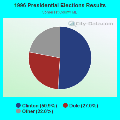
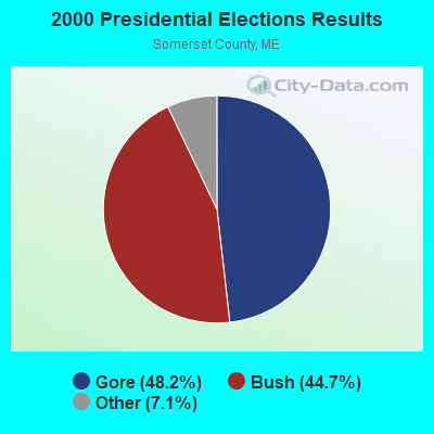
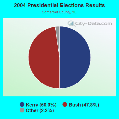
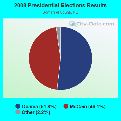
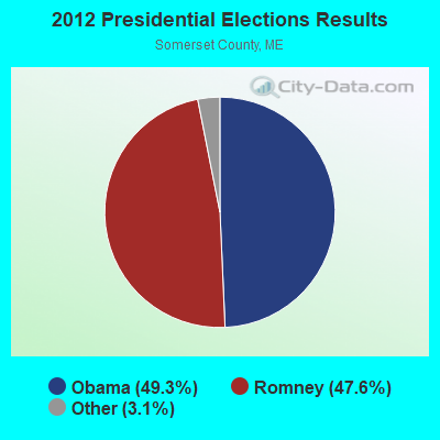
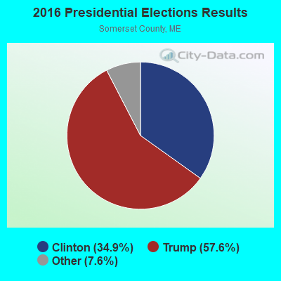
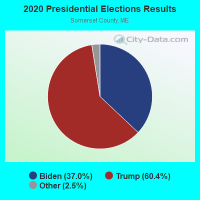
Graphs represent county-level data. Detailed 2008 Election Results
Religion statistics for Dennistown plantation, ME (based on Somerset County data)
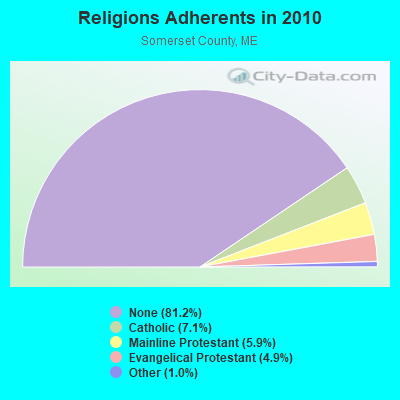
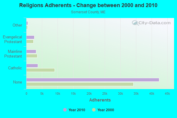
| Religion | Adherents | Congregations |
|---|---|---|
| Catholic | 3,694 | 7 |
| Mainline Protestant | 3,094 | 28 |
| Evangelical Protestant | 2,552 | 32 |
| Other | 501 | 3 |
| None | 42,387 | - |
Food Environment Statistics:
| Somerset County: | 2.52 / 10,000 pop. |
| Maine: | 2.80 / 10,000 pop. |
| Somerset County: | 0.19 / 10,000 pop. |
| Maine: | 0.14 / 10,000 pop. |
| Somerset County: | 2.71 / 10,000 pop. |
| Maine: | 2.20 / 10,000 pop. |
| Somerset County: | 9.31 / 10,000 pop. |
| State: | 5.75 / 10,000 pop. |
| Here: | 8.14 / 10,000 pop. |
| Maine: | 11.02 / 10,000 pop. |
| This county: | 10.2% |
| State: | 8.2% |
| Here: | 31.7% |
| Maine: | 25.0% |
Strongest AM radio stations in Dennistown plantation:
- WTME (780 AM; 10 kW; RUMFORD, ME; Owner: MOUNTAIN VALLEY BROADCASTING, INC.)
- WCHP (760 AM; 35 kW; CHAMPLAIN, NY; Owner: CHAMPLAIN RADIO, INC.)
- WSKW (1160 AM; 10 kW; SKOWHEGAN, ME; Owner: MOUNTAIN WIRELESS, INCORPORATED)
- WRKO (680 AM; 50 kW; BOSTON, MA; Owner: ENTERCOM BOSTON LICENSE, LLC)
- WNNZ (640 AM; 50 kW; WESTFIELD, MA; Owner: CLEAR CHANNEL BROADCASTING LICENSES, INC.)
- WEEI (850 AM; 50 kW; BOSTON, MA; Owner: ENTERCOM BOSTON LICENSE, LLC)
- WCRN (830 AM; 50 kW; WORCESTER, MA; Owner: CARTER BROADCASTING CORPORATION)
- WICY (1490 AM; 50 kW; MALONE, NY; Owner: CARTIER COMMUNICATIONS INC.)
- WBZ (1030 AM; 50 kW; BOSTON, MA; Owner: INFINITY BROADCASTING OPERATIONS, INC.)
- WZON (620 AM; 5 kW; BANGOR, ME; Owner: THE ZONE CORPORATION)
- WGY (810 AM; 50 kW; SCHENECTADY, NY; Owner: CLEAR CHANNEL BROADCASTING LICENSES, INC.)
- WKOX (1200 AM; 50 kW; FRAMINGHAM, MA; Owner: CAPSTAR TX LIMITED PARTNERSHIP)
- WALE (990 AM; 50 kW; GREENVILLE, RI; Owner: NORTH AMERICAN BROADCASTING CO., INC.)
Strongest FM radio stations in Dennistown plantation:
- WTOS-FM (105.1 FM; SKOWHEGAN, ME; Owner: CAPSTAR TX LIMITED PARTNERSHIP)
- National Bridge Inventory (NBI) Statistics
- 1Number of bridges
- 3ft / 0.9mTotal length
- 1,480Total average daily traffic
- 74Total average daily truck traffic
- 2,220Total future (year 2036) average daily traffic
Dennistown plantation compared to Maine state average:
- Median household income above state average.
- Black race population percentage significantly below state average.
- Hispanic race population percentage significantly below state average.
- Median age significantly below state average.
- Foreign-born population percentage significantly below state average.
- Renting percentage significantly below state average.
- Length of stay since moving in significantly above state average.
- Number of rooms per house significantly below state average.
- House age significantly below state average.
Dennistown plantation on our top lists:
- #47 on the list of "Top 101 larger cities with the lowest real estate taxes percentage (population 50,000+)"
- #37 on the list of "Top 101 counties with the smallest number of people without health insurance coverage in 2000 (pop. 50,000+)"
- #37 on the list of "Top 101 counties with the smallest number of children under 18 without health insurance coverage in 2000 (pop. 50,000+)"
- #50 on the list of "Top 101 counties with highest percentage of residents voting for 3rd party candidates in the 2012 Presidential Election (pop. 50,000+)"
- #52 on the list of "Top 101 counties with the lowest total withdrawal of fresh water for public supply (pop. 50,000+)"
- #79 on the list of "Top 101 counties with the lowest surface withdrawal of fresh water for public supply (pop. 50,000+)"