Dekorra, Wisconsin
Submit your own pictures of this town and show them to the world
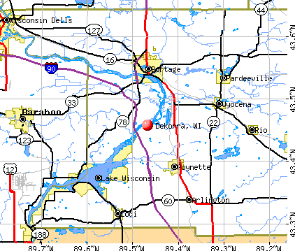
- OSM Map
- General Map
- Google Map
- MSN Map
Population change since 2000: -1.7%
 |
| Males: 1,205 | |
| Females: 1,106 |
| Median resident age: | 47.6 years |
| Wisconsin median age: | 42.6 years |
Zip codes: 53955.
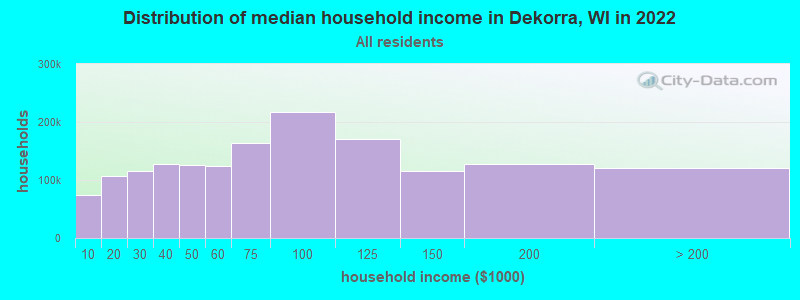
| Dekorra: | $96,067 |
| WI: | $70,996 |
Estimated per capita income in 2022: $48,438 (it was $25,319 in 2000)
Dekorra town income, earnings, and wages data
Estimated median house or condo value in 2022: $323,524 (it was $144,300 in 2000)
| Dekorra: | $323,524 |
| WI: | $252,800 |
Mean prices in 2022: all housing units: $327,309; detached houses: $337,146; townhouses or other attached units: $267,084; in 2-unit structures: $277,464; in 3-to-4-unit structures: $247,432; in 5-or-more-unit structures: $305,110; mobile homes: $52,521
Detailed information about poverty and poor residents in Dekorra, WI


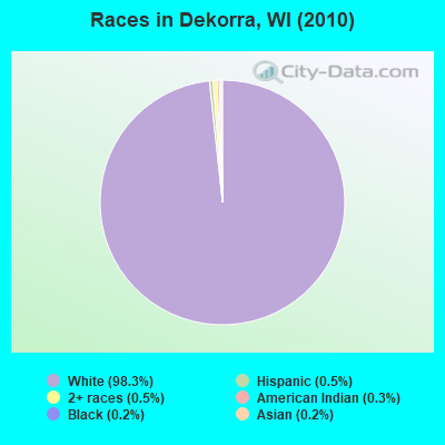
- 2,27298.3%White alone
- 110.5%Two or more races
- 120.5%Hispanic
- 70.3%American Indian alone
- 50.2%Black alone
- 40.2%Asian alone
Races in Dekorra detailed stats: ancestries, foreign born residents, place of birth
 Recent articles from our blog. Our writers, many of them Ph.D. graduates or candidates, create easy-to-read articles on a wide variety of topics.

 | Best cell phone carrier? (19 replies) |
| ALL YOU CAN EAT fish fry (5 replies) |
| Images of Wisconsin (1655 replies) |
| what part of NO Trespassing do some farmers not understand? (5 replies) |
| Just Moved To Wi From Co - What's Up With The High Property Taxes? (71 replies) |
Latest news from Dekorra, WI collected exclusively by city-data.com from local newspapers, TV, and radio stations
Ancestries: German (50.8%), Norwegian (14.4%), Irish (10.6%), English (10.4%), United States (5.2%), Polish (4.3%).
Current Local Time: CST time zone
Elevation: 800 feet
Land area: 41.1 square miles.
Population density: 56 people per square mile (very low).
39 residents are foreign born
| This town: | 1.7% |
| Wisconsin: | 3.6% |
| Dekorra town: | 1.3% ($1,923) |
| Wisconsin: | 2.0% ($2,245) |
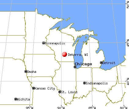
Nearest city with pop. 50,000+: Madison, WI  (23.9 miles , pop. 208,054).
Nearest city with pop. 1,000,000+: Chicago, IL (141.3 miles , pop. 2,896,016).
Nearest cities:
), ), ), ), Latitude: 43.42 N, Longitude: 89.45 W
Area code commonly used in this area: 608

| Here: | 2.3% |
| Wisconsin: | 2.7% |
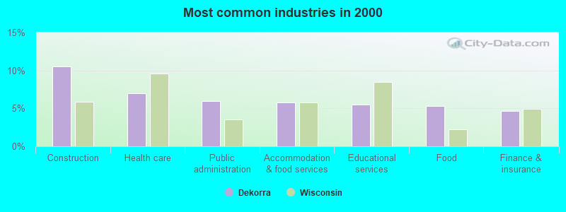
- Construction (10.5%)
- Health care (7.0%)
- Public administration (6.0%)
- Accommodation & food services (5.8%)
- Educational services (5.5%)
- Food (5.3%)
- Finance & insurance (4.7%)
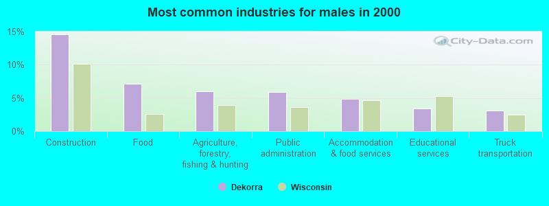
- Construction (14.6%)
- Food (7.1%)
- Agriculture, forestry, fishing & hunting (6.0%)
- Public administration (5.9%)
- Accommodation & food services (4.9%)
- Educational services (3.4%)
- Truck transportation (3.2%)
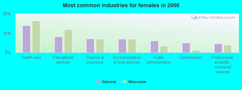
- Health care (14.0%)
- Educational services (8.3%)
- Finance & insurance (7.2%)
- Accommodation & food services (7.0%)
- Public administration (6.1%)
- Construction (5.0%)
- Professional, scientific, technical services (4.7%)
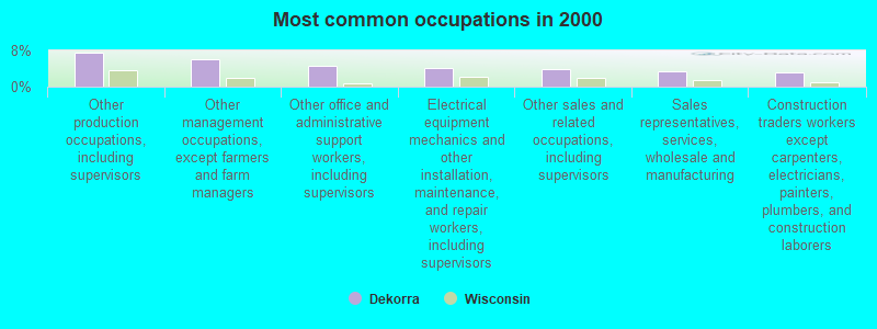
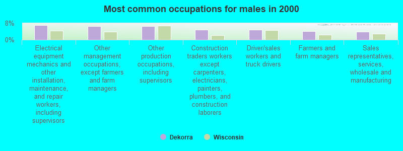
- Other production occupations, including supervisors (7.6%)
- Other management occupations, except farmers and farm managers (6.1%)
- Other office and administrative support workers, including supervisors (4.7%)
- Electrical equipment mechanics and other installation, maintenance, and repair workers, including supervisors (4.1%)
- Other sales and related occupations, including supervisors (3.9%)
- Sales representatives, services, wholesale and manufacturing (3.4%)
- Construction traders workers except carpenters, electricians, painters, plumbers, and construction laborers (3.2%)
- Electrical equipment mechanics and other installation, maintenance, and repair workers, including supervisors (7.1%)
- Other management occupations, except farmers and farm managers (6.6%)
- Other production occupations, including supervisors (6.6%)
- Construction traders workers except carpenters, electricians, painters, plumbers, and construction laborers (4.9%)
- Driver/sales workers and truck drivers (4.7%)
- Farmers and farm managers (4.1%)
- Sales representatives, services, wholesale and manufacturing (3.8%)
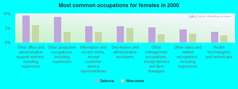
- Other office and administrative support workers, including supervisors (9.5%)
- Other production occupations, including supervisors (9.0%)
- Information and record clerks, except customer service representatives (5.7%)
- Secretaries and administrative assistants (5.7%)
- Other management occupations, except farmers and farm managers (5.4%)
- Other sales and related occupations, including supervisors (4.7%)
- Health technologists and technicians (3.8%)
Average climate in Dekorra, Wisconsin
Based on data reported by over 4,000 weather stations


(lower is better)
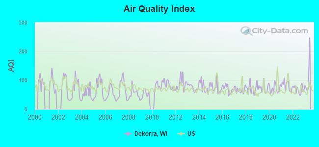
Air Quality Index (AQI) level in 2022 was 68.0. This is about average.
| City: | 68.0 |
| U.S.: | 72.6 |
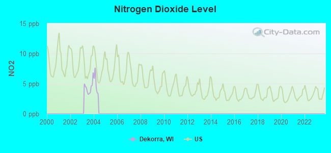
Nitrogen Dioxide (NO2) [ppb] level in 2003 was 4.36. This is about average. Closest monitor was 3.0 miles away from the city center.
| City: | 4.36 |
| U.S.: | 5.11 |
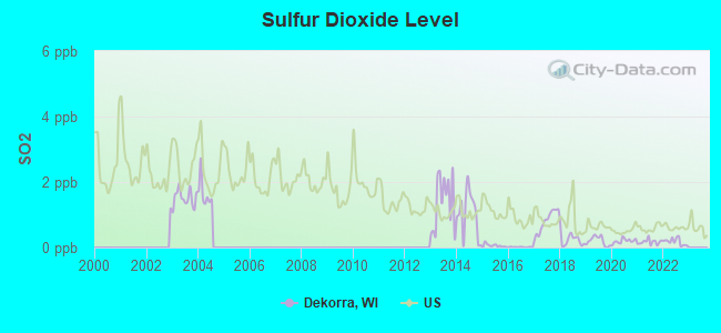
Sulfur Dioxide (SO2) [ppb] level in 2022 was 0.176. This is significantly better than average. Closest monitor was 2.9 miles away from the city center.
| City: | 0.176 |
| U.S.: | 1.515 |
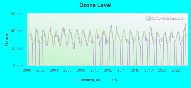
Ozone [ppb] level in 2022 was 32.0. This is about average. Closest monitor was 3.0 miles away from the city center.
| City: | 32.0 |
| U.S.: | 33.3 |
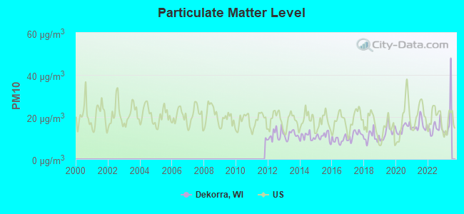
Particulate Matter (PM10) [µg/m3] level in 2022 was 14.7. This is better than average. Closest monitor was 11.8 miles away from the city center.
| City: | 14.7 |
| U.S.: | 19.2 |
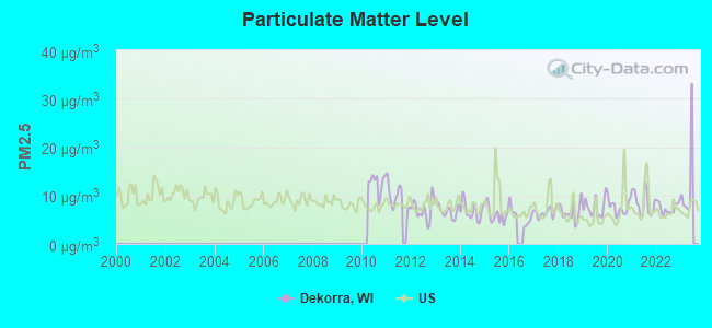
Particulate Matter (PM2.5) [µg/m3] level in 2022 was 7.41. This is about average. Closest monitor was 11.8 miles away from the city center.
| City: | 7.41 |
| U.S.: | 8.11 |
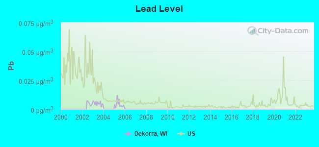
Lead (Pb) [µg/m3] level in 2005 was 0.00428. This is significantly better than average. Closest monitor was 3.3 miles away from the city center.
| City: | 0.00428 |
| U.S.: | 0.00931 |
Tornado activity:
Dekorra-area historical tornado activity is above Wisconsin state average. It is 74% greater than the overall U.S. average.
On 6/7/1984, a category F5 (max. wind speeds 261-318 mph) tornado 10.3 miles away from the Dekorra town center killed 9 people and injured 200 people and caused between $50,000 and $500,000 in damages.
On 9/26/1951, a category F4 (max. wind speeds 207-260 mph) tornado 10.4 miles away from the town center killed one person and injured 9 people and caused between $50,000 and $500,000 in damages.
Earthquake activity:
Dekorra-area historical earthquake activity is significantly above Wisconsin state average. It is 28% greater than the overall U.S. average.On 4/18/2008 at 09:36:59, a magnitude 5.4 (5.1 MB, 4.8 MS, 5.4 MW, 5.2 MW, Class: Moderate, Intensity: VI - VII) earthquake occurred 353.0 miles away from the city center
On 6/28/2004 at 06:10:52, a magnitude 4.2 (4.2 MW, Depth: 6.2 mi, Class: Light, Intensity: IV - V) earthquake occurred 138.3 miles away from Dekorra center
On 6/10/1987 at 23:48:54, a magnitude 5.1 (4.9 MB, 4.4 MS, 4.6 MS, 5.1 LG) earthquake occurred 328.2 miles away from Dekorra center
On 4/18/2008 at 09:36:59, a magnitude 5.2 (5.2 MW, Depth: 8.9 mi) earthquake occurred 353.0 miles away from Dekorra center
On 2/10/2010 at 09:59:35, a magnitude 3.8 (3.8 MW, Depth: 6.2 mi, Class: Light, Intensity: II - III) earthquake occurred 111.2 miles away from Dekorra center
On 5/2/2015 at 16:23:07, a magnitude 4.2 (4.2 MW, Depth: 2.8 mi) earthquake occurred 219.5 miles away from Dekorra center
Magnitude types: regional Lg-wave magnitude (LG), body-wave magnitude (MB), surface-wave magnitude (MS), moment magnitude (MW)
Natural disasters:
The number of natural disasters in Columbia County (10) is smaller than the US average (15).Major Disasters (Presidential) Declared: 7
Emergencies Declared: 3
Causes of natural disasters: Floods: 6, Storms: 6, Tornadoes: 3, Drought: 1, Hurricane: 1, Wind: 1, Winter Storm: 1, Other: 1 (Note: some incidents may be assigned to more than one category).
Hospitals and medical centers near Dekorra:
- GOOD SAMARITAN SOCIETY-LODI (Nursing Home, about 8 miles away; LODI, WI)
- COLUMBIA HLTH CARE CTR (Nursing Home, about 9 miles away; WYOCENA, WI)
- DIVINE SAVIOR HEALTHCARE DIALYSIS (Dialysis Facility, about 11 miles away; PORTAGE, WI)
- DIVINE SAVIOR HLTHCARE Acute Care Hospitals (about 11 miles away; PORTAGE, WI)
- ST CLARE MEADOWS CARE CTR (Nursing Home, about 15 miles away; BARABOO, WI)
- ST CLARE DIALYSIS CTR (Dialysis Facility, about 15 miles away; BARABOO, WI)
- HOME HEALTH UNITED HSPC (Hospital, about 15 miles away; BARABOO, WI)
Colleges/universities with over 2000 students nearest to Dekorra:
- Herzing University-Madison (about 21 miles; Madison, WI; Full-time enrollment: 3,160)
- Madison Area Technical College (about 22 miles; Madison, WI; FT enrollment: 9,603)
- University of Wisconsin-Madison (about 24 miles; Madison, WI; FT enrollment: 34,621)
- University of Wisconsin Colleges (about 25 miles; Madison, WI; FT enrollment: 10,019)
- Edgewood College (about 25 miles; Madison, WI; FT enrollment: 2,455)
- University of Wisconsin-Whitewater (about 54 miles; Whitewater, WI; FT enrollment: 11,124)
- Marian University (about 58 miles; Fond Du Lac, WI; FT enrollment: 2,045)
Points of interest:
Notable location: Poynette State Game Farm (A). Display/hide its location on the map
Churches in Dekorra include: Inch Church (A), Dekorra Church (B). Display/hide their locations on the map
Cemeteries: Schofield Cemetery (1), Dekorra Lutheran Cemetery (2), Dekorra Cemetery (3), Inch Cemetery (4). Display/hide their locations on the map
Lake: Fulton Pond (A). Display/hide its location on the map
Streams, rivers, and creeks: Hinkson Creek (A), Rocky Run (B), Rowan Creek (C). Display/hide their locations on the map
Parks in Dekorra include: Camp Rest Park (1), Happy Hollow Park (2). Display/hide their locations on the map
| This town: | 2.4 people |
| Wisconsin: | 2.4 people |
| This town: | 70.5% |
| Whole state: | 64.4% |
| This town: | 7.1% |
| Whole state: | 7.3% |
Likely homosexual households (counted as self-reported same-sex unmarried-partner households)
- Lesbian couples: 0.1% of all households
- Gay men: 0.2% of all households
| This town: | 2.1% |
| Whole state: | 8.7% |
| This town: | 1.0% |
| Whole state: | 3.7% |
For population 15 years and over in Dekorra:
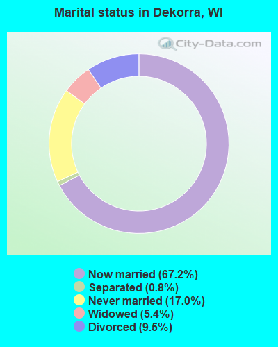
- Never married: 17.0%
- Now married: 67.2%
- Separated: 0.8%
- Widowed: 5.4%
- Divorced: 9.5%
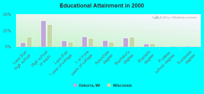
For population 25 years and over in Dekorra:
- High school or higher: 93.5%
- Bachelor's degree or higher: 19.1%
- Graduate or professional degree: 5.5%
- Unemployed: 3.4%
- Mean travel time to work (commute): 30.3 minutes
| Here: | 8.5 |
| Wisconsin average: | 11.0 |
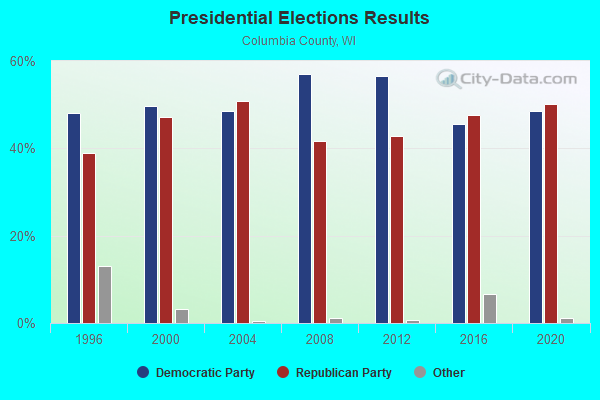
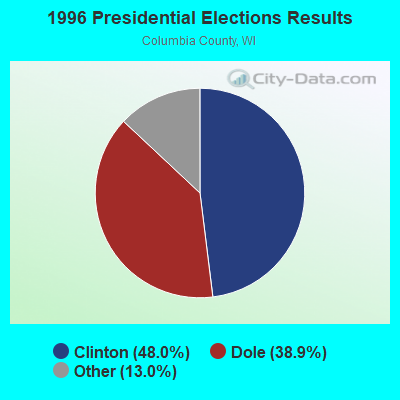
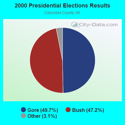
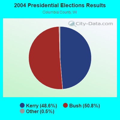
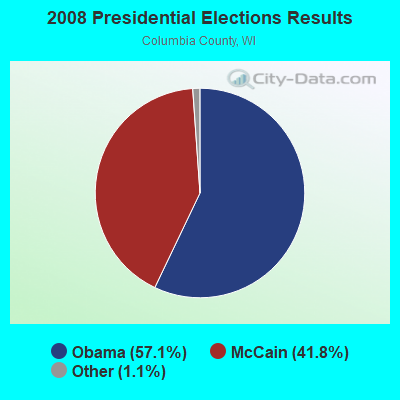


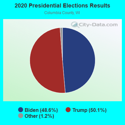
Graphs represent county-level data. Detailed 2008 Election Results
Religion statistics for Dekorra, WI (based on Columbia County data)
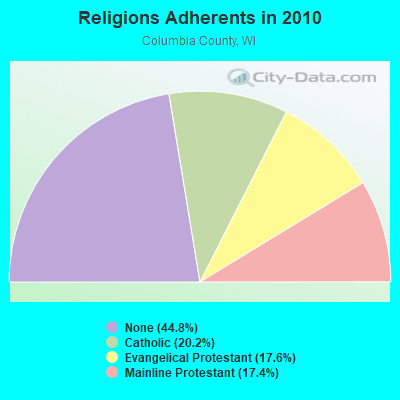
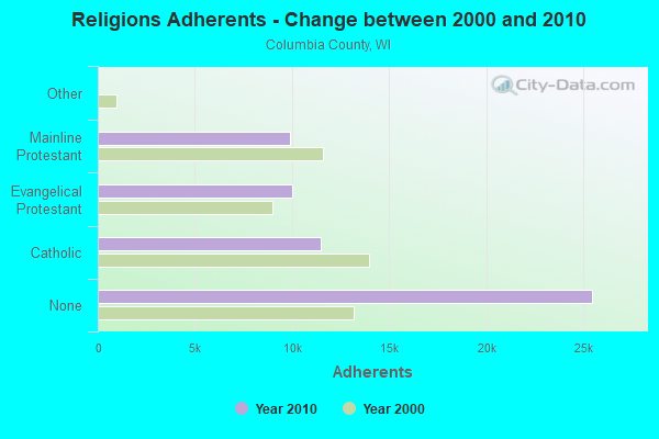
| Religion | Adherents | Congregations |
|---|---|---|
| Catholic | 11,473 | 9 |
| Evangelical Protestant | 9,990 | 44 |
| Mainline Protestant | 9,911 | 34 |
| Other | 9 | 3 |
| None | 25,450 | - |
Food Environment Statistics:
| Columbia County: | 1.81 / 10,000 pop. |
| Wisconsin: | 1.86 / 10,000 pop. |
| Columbia County: | 0.36 / 10,000 pop. |
| Wisconsin: | 0.11 / 10,000 pop. |
| Columbia County: | 6.35 / 10,000 pop. |
| Wisconsin: | 4.12 / 10,000 pop. |
| Columbia County: | 12.33 / 10,000 pop. |
| State: | 8.64 / 10,000 pop. |
| Columbia County: | 7.3% |
| Wisconsin: | 7.6% |
| This county: | 26.8% |
| Wisconsin: | 27.5% |
| This county: | 14.0% |
| Wisconsin: | 13.0% |
Strongest AM radio stations in Dekorra:
- WHFA (1240 AM; 1 kW; POYNETTE, WI; Owner: STARBOARD BROADCASTING, INC.)
- WPDR (1350 AM; 1 kW; PORTAGE, WI; Owner: ZOE COMMUNICATIONS, INC.)
- WTMJ (620 AM; 50 kW; MILWAUKEE, WI; Owner: JOURNAL BROADCAST CORPORATION)
- WTSO (1070 AM; 10 kW; MADISON, WI; Owner: CAPSTAR TX LIMITED PARTNERSHIP)
- WLMV (1480 AM; 10 kW; MADISON, WI; Owner: MID-WEST MANAGEMENT, INC.)
- WNAM (1280 AM; 50 kW; NEENAH-MENASHA, WI; Owner: CUMULUS LICENSING CORP.)
- WNWC (1190 AM; daytime; 5 kW; SUN PRAIRIE, WI; Owner: NORTHWESTERN COLLEGE)
- WTDY (1670 AM; 10 kW; MADISON, WI; Owner: MID-WEST MANAGEMENT, INC.)
- WSPT (1010 AM; 50 kW; STEVENS POINT, WI)
- WHA (970 AM; 5 kW; MADISON, WI; Owner: BOARD REGENTS OF UNIV OF WI SYSTEM)
- WISN (1130 AM; 50 kW; MILWAUKEE, WI; Owner: CAPSTAR TX LIMITED PARTNERSHIP)
- WHBY (1150 AM; 25 kW; KIMBERLY, WI; Owner: WOODWARD COMMUNICATIONS, INC.)
- WIBA (1310 AM; 5 kW; MADISON, WI; Owner: CAPSTAR TX LIMITED PARTNERSHIP)
Strongest FM radio stations in Dekorra:
- WOLX-FM (94.9 FM; BARABOO, WI; Owner: ENTERCOM MADISON LICENSE, LLC.)
- WDDC (100.1 FM; PORTAGE, WI; Owner: ZOE COMMUNICATIONS, INC.)
- WERN (88.7 FM; MADISON, WI; Owner: STATE OF WISCONSIN - EDUCATIONAL COMMUNICATIONS BOARD)
- WCJZ (96.3 FM; SAUK CITY, WI; Owner: CAPSTAR TX LIMITED PARTNERSHIP)
- WIBA-FM (101.5 FM; MADISON, WI; Owner: CAPSTAR TX LIMITED PARTNERSHIP)
- WZEE (104.1 FM; MADISON, WI; Owner: CAPSTAR TX LIMITED PARTNERSHIP)
- WORT (89.9 FM; MADISON, WI; Owner: BACK PORCH RADIO BROADCASTING, INC.)
- WBZU (105.1 FM; WAUNAKEE, WI; Owner: ENTERCOM MADISON LICENSE, LLC.)
- WMAD-FM (92.1 FM; SUN PRAIRIE, WI; Owner: CAPSTAR TX LIMITED PARTNERSHIP)
- WBKY (95.9 FM; PORTAGE, WI; Owner: MAGNUM COMMUNICATIONS, INC.)
- W215AQ (90.9 FM; MADISON, WI; Owner: STATE OF WISCONSIN - EDUCATIONAL COMMUNICATIONS BOARD)
- WJWD (90.3 FM; MARSHALL, WI; Owner: CSN INTERNATIONAL)
- WTLX (100.5 FM; COLUMBUS, WI; Owner: GOOD KARMA BROADCASTING, L.L.C.)
- WMGN (98.1 FM; MADISON, WI; Owner: MID-WEST MANAGEMENT, INC.)
- WMMM-FM (105.5 FM; VERONA, WI; Owner: ENTERCOM MADISON LICENSE, LLC.)
- WNNO-FM (106.9 FM; WISCONSIN DELLS, WI; Owner: MAGNUM COMMUNICATIONS, INC.)
- WNWC-FM (102.5 FM; MADISON, WI; Owner: NORTHWESTERN COLLEGE)
- WHIT-FM (93.1 FM; DE FOREST, WI; Owner: MID-WEST MANAGEMENT, INC.)
- WWQM-FM (106.3 FM; MIDDLETON, WI; Owner: MID-WEST MANAGEMENT INC.)
TV broadcast stations around Dekorra:
- WISC-TV (Channel 3; MADISON, WI; Owner: TELEVISION WISCONSIN, INC.)
- WMSN-TV (Channel 47; MADISON, WI; Owner: WMSN LICENSEE, LLC)
- WKOW-TV (Channel 27; MADISON, WI; Owner: WKOW TELEVISION, INC.)
- WHA-TV (Channel 21; MADISON, WI; Owner: BOARD OF REGENTS OF THE UNIV. OF WISCONSIN SYSTEM)
- WMTV (Channel 15; MADISON, WI; Owner: GRAY MIDAMERICA TV LICENSEE CORP.)
- W58CO (Channel 58; SAULT STE. MARIE, MI; Owner: MS COMMUNICATIONS, LLC)
- WWRS-TV (Channel 52; MAYVILLE, WI; Owner: NATIONAL MINORITY T.V., INC.)
- W23BW (Channel 23; MADISON, WI; Owner: THREE ANGELS BROADCASTING NETWORK)
- W38CT (Channel 38; MADISON, WI; Owner: TRINITY BROADCASTING NETWORK)
- National Bridge Inventory (NBI) Statistics
- 20Number of bridges
- 512ft / 156mTotal length
- $2,040,000Total costs
- 345,971Total average daily traffic
- 50,682Total average daily truck traffic
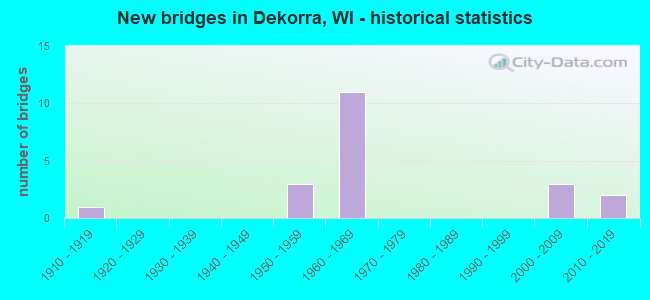
- New bridges - historical statistics
- 11910-1919
- 31950-1959
- 111960-1969
- 32000-2009
- 22010-2019
FCC Registered Antenna Towers:
10 (See the full list of FCC Registered Antenna Towers in Dekorra)FCC Registered Microwave Towers:
2- ML15AL192, Na (Lat: 43.414500 Lon: -89.468694), Type: Mtower, Structure height: 56.1 m, Overall height: 60.7 m, Call Sign: WQRZ420,
Assigned Frequencies: 11245.0 MHz, 11245.0 MHz, 11245.0 MHz, Grant Date: 08/19/2013, Expiration Date: 08/19/2023, Cancellation Date: 05/16/2023, Certifier: David Werblow, Registrant: T-Mobile Usa, Inc., 12920 Se 38th Street, Bellevue, WA 98006, Phone: (425) 383-8401, Email:
- ML73827A, Na (Lat: 43.414500 Lon: -89.468694), Type: Mtower, Structure height: 56.1 m, Overall height: 60.7 m, Call Sign: WRCV897,
Assigned Frequencies: 21825.0 MHz, 21825.0 MHz, 21825.0 MHz, 21825.0 MHz, 21825.0 MHz, 21825.0 MHz, 21825.0 MHz, 21825.0 MHz, 21825.0 MHz, 21825.0 MHz, Grant Date: 02/11/2019, Expiration Date: 02/11/2029, Cancellation Date: 11/25/2022, Certifier: David Werblow, Registrant: T-Mobile Usa, Inc., 12920 Se 38th Street, Bellevue, WA 98006, Phone: (425) 383-8401, Fax: (425) 383-4040, Email:
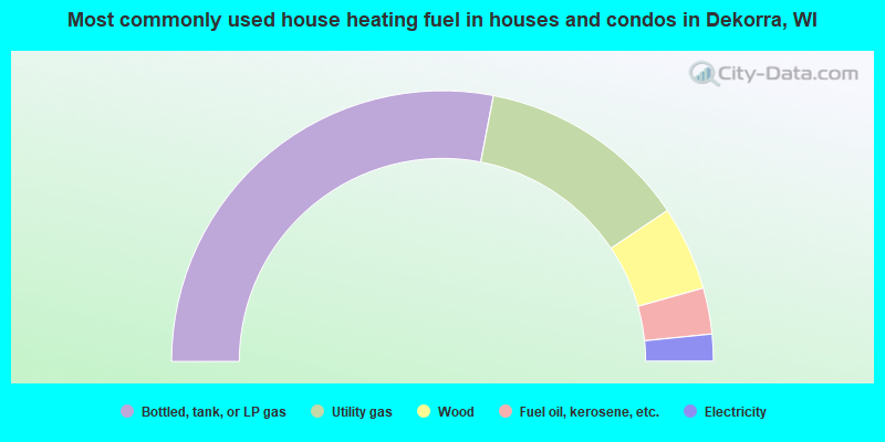
- 56.0%Bottled, tank, or LP gas
- 25.1%Utility gas
- 10.1%Wood
- 5.5%Fuel oil, kerosene, etc.
- 3.2%Electricity
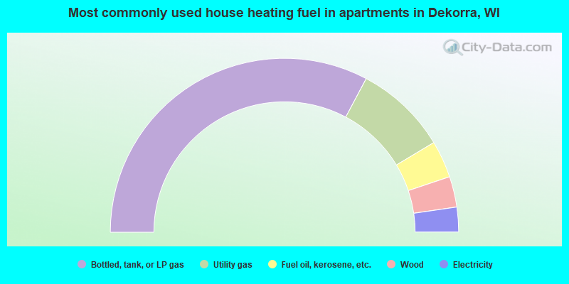
- 65.5%Bottled, tank, or LP gas
- 17.2%Utility gas
- 6.9%Fuel oil, kerosene, etc.
- 5.7%Wood
- 4.6%Electricity
Dekorra compared to Wisconsin state average:
- Unemployed percentage significantly below state average.
- Black race population percentage significantly below state average.
- Hispanic race population percentage significantly below state average.
- Median age above state average.
- Foreign-born population percentage significantly below state average.
- Renting percentage significantly below state average.
- Length of stay since moving in significantly above state average.
- Number of rooms per house significantly below state average.
- House age significantly below state average.
- Number of college students below state average.