Deerfield, Tennessee
Submit your own pictures of this place and show them to the world
- OSM Map
- General Map
- Google Map
- MSN Map

| Males: 1,223 | |
| Females: 1,206 |
| Median resident age: | 35.8 years |
| Tennessee median age: | 35.9 years |
Zip code: 38464
| Deerfield: | $55,550 |
| TN: | $65,254 |
Estimated per capita income in 2022: $24,147 (it was $13,987 in 2000)
Deerfield CCD income, earnings, and wages data
Estimated median house or condo value in 2022: $170,404 (it was $64,600 in 2000)
| Deerfield: | $170,404 |
| TN: | $284,800 |
Detailed information about poverty and poor residents in Deerfield, TN


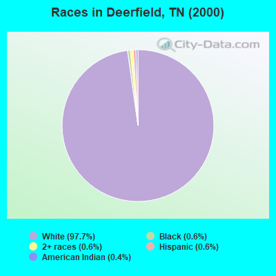
- 2,32097.7%White alone
- 150.6%Black alone
- 140.6%Two or more races
- 140.6%Hispanic
- 90.4%American Indian alone
- 20.08%Native Hawaiian and Other
Pacific Islander alone - 10.04%Asian alone
Races in Deerfield detailed stats: ancestries, foreign born residents, place of birth
 Recent articles from our blog. Our writers, many of them Ph.D. graduates or candidates, create easy-to-read articles on a wide variety of topics.
Current Local Time: CST time zone
Land area: 103.0 square miles.
Population density: 24 people per square mile (very low).

| Deerfield CCD: | 0.5% ($343) |
| Tennessee: | 0.8% ($715) |
Nearest city with pop. 50,000+: Decatur, AL  (58.4 miles , pop. 53,929).
Nearest city with pop. 200,000+: Metropolitan Government, TN (72.0 miles , pop. 569,891).
Nearest city with pop. 1,000,000+: Chicago, IL (451.9 miles , pop. 2,896,016).
Nearest cities:
), ), )Latitude: 35.31 N, Longitude: 87.51 W
Area code commonly used in this area: 931

| Here: | 3.1% |
| Tennessee: | 3.0% |
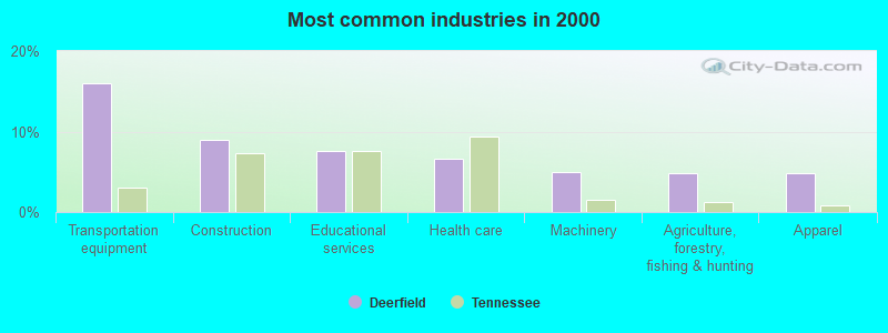
- Transportation equipment (16.0%)
- Construction (9.0%)
- Educational services (7.6%)
- Health care (6.7%)
- Machinery (4.9%)
- Agriculture, forestry, fishing & hunting (4.8%)
- Apparel (4.8%)
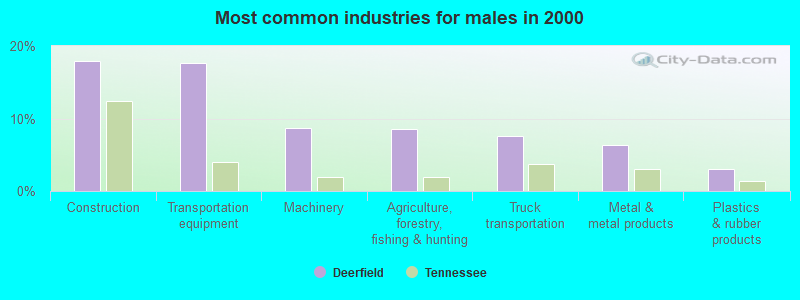
- Construction (17.9%)
- Transportation equipment (17.7%)
- Machinery (8.8%)
- Agriculture, forestry, fishing & hunting (8.6%)
- Truck transportation (7.5%)
- Metal & metal products (6.3%)
- Plastics & rubber products (3.1%)
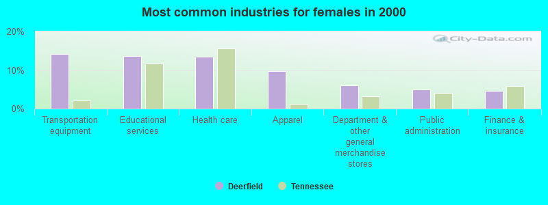
- Transportation equipment (14.2%)
- Educational services (13.6%)
- Health care (13.4%)
- Apparel (9.7%)
- Department & other general merchandise stores (6.0%)
- Public administration (4.9%)
- Finance & insurance (4.5%)
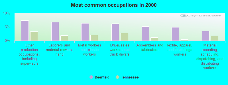
- Other production occupations, including supervisors (7.3%)
- Laborers and material movers, hand (6.7%)
- Metal workers and plastic workers (6.2%)
- Driver/sales workers and truck drivers (6.1%)
- Assemblers and fabricators (5.1%)
- Textile, apparel, and furnishings workers (4.8%)
- Material recording, scheduling, dispatching, and distributing workers (3.5%)
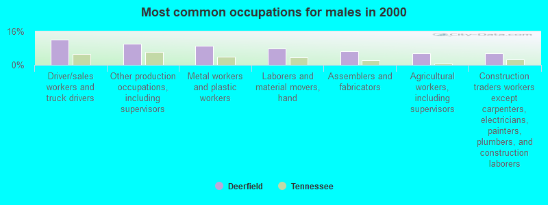
- Driver/sales workers and truck drivers (12.2%)
- Other production occupations, including supervisors (10.0%)
- Metal workers and plastic workers (9.2%)
- Laborers and material movers, hand (7.9%)
- Assemblers and fabricators (6.5%)
- Agricultural workers, including supervisors (5.5%)
- Construction traders workers except carpenters, electricians, painters, plumbers, and construction laborers (5.5%)
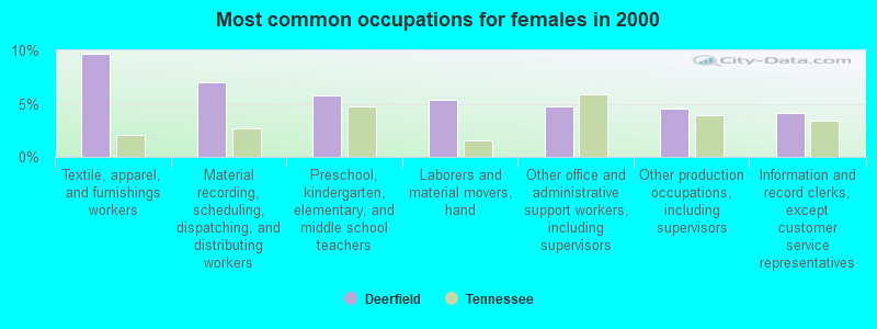
- Textile, apparel, and furnishings workers (9.7%)
- Material recording, scheduling, dispatching, and distributing workers (7.0%)
- Preschool, kindergarten, elementary, and middle school teachers (5.8%)
- Laborers and material movers, hand (5.4%)
- Other office and administrative support workers, including supervisors (4.7%)
- Other production occupations, including supervisors (4.5%)
- Information and record clerks, except customer service representatives (4.1%)
Average climate in Deerfield, Tennessee
Based on data reported by over 4,000 weather stations


(lower is better)
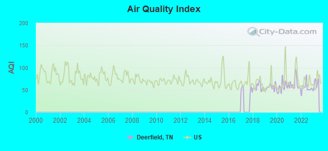
Air Quality Index (AQI) level in 2022 was 55.1. This is better than average.
| City: | 55.1 |
| U.S.: | 72.6 |
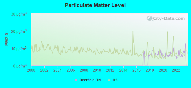
Particulate Matter (PM2.5) [µg/m3] level in 2022 was 5.72. This is significantly better than average. Closest monitor was 13.5 miles away from the city center.
| City: | 5.72 |
| U.S.: | 8.11 |
Tornado activity:
Deerfield-area historical tornado activity is slightly above Tennessee state average. It is 93% greater than the overall U.S. average.
On 4/16/1998, a category F5 (max. wind speeds 261-318 mph) tornado 29.6 miles away from the Deerfield place center killed 3 people and injured 36 people and caused $13 million in damages.
On 5/18/1995, a category F4 (max. wind speeds 207-260 mph) tornado 19.3 miles away from the place center killed 3 people and injured 32 people and caused between $500,000 and $5,000,000 in damages.
Earthquake activity:
Deerfield-area historical earthquake activity is significantly above Tennessee state average. It is 227% greater than the overall U.S. average.On 4/18/2008 at 09:36:59, a magnitude 5.4 (5.1 MB, 4.8 MS, 5.4 MW, 5.2 MW, Class: Moderate, Intensity: VI - VII) earthquake occurred 218.5 miles away from Deerfield center
On 4/29/2003 at 08:59:39, a magnitude 4.9 (4.4 MB, 4.6 MW, 4.9 LG, Class: Light, Intensity: IV - V) earthquake occurred 120.5 miles away from the city center
On 5/4/1991 at 01:18:54, a magnitude 5.0 (4.4 MB, 4.6 LG, 5.0 LG, Depth: 3.1 mi) earthquake occurred 156.1 miles away from Deerfield center
On 3/25/1976 at 00:41:20, a magnitude 5.0 (4.9 MB, 5.0 LG) earthquake occurred 160.4 miles away from the city center
On 9/26/1990 at 13:18:51, a magnitude 5.0 (4.7 MB, 4.8 LG, 5.0 LG, Depth: 7.7 mi) earthquake occurred 171.2 miles away from Deerfield center
On 1/18/1999 at 07:00:53, a magnitude 4.8 (4.8 MB, 4.0 LG, Depth: 0.6 mi) earthquake occurred 132.4 miles away from the city center
Magnitude types: regional Lg-wave magnitude (LG), body-wave magnitude (MB), surface-wave magnitude (MS), moment magnitude (MW)
Natural disasters:
The number of natural disasters in Lawrence County (20) is greater than the US average (15).Major Disasters (Presidential) Declared: 16
Emergencies Declared: 2
Causes of natural disasters: Floods: 13, Storms: 11, Tornadoes: 8, Winds: 5, Winter Storms: 4, Heavy Rains: 2, Flash Flood: 1, Hurricane: 1, Ice Storm: 1, Landslide: 1, Mudslide: 1, Snowfall: 1, Other: 1 (Note: some incidents may be assigned to more than one category).
Hospitals and medical centers near Deerfield:
- COUNTRYSIDE HEALTHCARE AND REHABILITATION (Nursing Home, about 9 miles away; LAWRENCEBURG, TN)
- NHC HEALTHCARE, SCOTT (Nursing Home, about 10 miles away; LAWRENCEBURG, TN)
- NHC HEALTHCARE, LAWRENCEBURG (Nursing Home, about 11 miles away; LAWRENCEBURG, TN)
- FMC LAWRENCEBURG (Dialysis Facility, about 12 miles away; LAWRENCEBURG, TN)
- WAYNE CARE NURSING HOME (Nursing Home, about 15 miles away; WAYNESBORO, TN)
Colleges/universities with over 2000 students nearest to Deerfield:
- Columbia State Community College (about 32 miles; Columbia, TN; Full-time enrollment: 3,383)
- University of North Alabama (about 37 miles; Florence, AL; FT enrollment: 5,886)
- Northwest-Shoals Community College (about 41 miles; Muscle Shoals, AL; FT enrollment: 2,702)
- Athens State University (about 47 miles; Athens, AL; FT enrollment: 2,771)
- John C Calhoun State Community College (about 56 miles; Tanner, AL; FT enrollment: 7,911)
- University of Alabama in Huntsville (about 64 miles; Huntsville, AL; FT enrollment: 6,006)
- Alabama A & M University (about 65 miles; Normal, AL; FT enrollment: 4,524)
Points of interest:
Notable locations in Deerfield: Laurel Hill (A), Ovilla Volunteer Fire Department (B), West End Volunteer Fire Department (C). Display/hide their locations on the map
Churches in Deerfield include: Rochelle Church (A), Beech Grove Church (B), Knob Creek Church (C), Unity Church of God (D), Pea Ridge Church of Christ (E), Mount Lebanon Church (F), Deerfield Baptist Church (G), Canaan Freewill Baptist Church (H), Greenwood Church (I). Display/hide their locations on the map
Cemeteries: Kilburn Cemetery (1), Laurel Hill Cemetery (2), Luna Cemetery (3), Gravel Hill Cemetery (4), Unity Cemetery (5), Rochelle Cemetery (6), Pea Ridge Cemetery (7). Display/hide their locations on the map
Lakes and reservoirs: Lourdes Lake (A), VFW Lake (B), Veterans of Foreign Wars Lake (C), Laurel Hill Lake (D). Display/hide their locations on the map
Streams, rivers, and creeks: Lutts Branch (A), Kidd Branch (B), Kelly Spring Branch (C), Ham Branch (D), Turkeypen Branch (E), Grews Branch (F), Granddaddy Creek (G), Goss Branch (H), Gildridge Branch (I). Display/hide their locations on the map
Park in Deerfield: Laurel Hill Wildlife Management Area (1). Display/hide its location on the map
| This place: | 2.7 people |
| Tennessee: | 2.5 people |
| This place: | 72.9% |
| Whole state: | 69.8% |
| This place: | 3.7% |
| Whole state: | 4.2% |
No gay or lesbian households reported
| This place: | 14.4% |
| Whole state: | 13.5% |
| This place: | 5.7% |
| Whole state: | 5.8% |
For population 15 years and over in Deerfield:
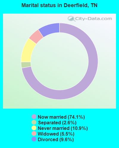
- Never married: 10.9%
- Now married: 74.1%
- Separated: 2.6%
- Widowed: 5.5%
- Divorced: 9.6%
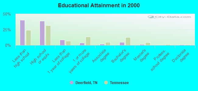
For population 25 years and over in Deerfield:
- High school or higher: 59.7%
- Bachelor's degree or higher: 7.0%
- Graduate or professional degree: 2.2%
- Unemployed: 9.5%
- Mean travel time to work (commute): 28.1 minutes
| Here: | 14.4 |
| Tennessee average: | 13.3 |
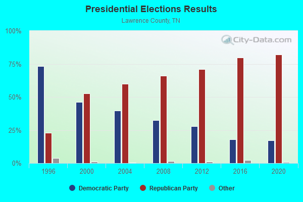
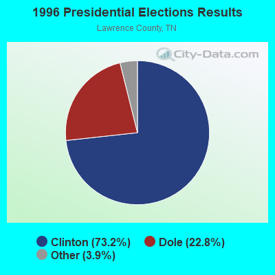
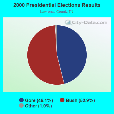
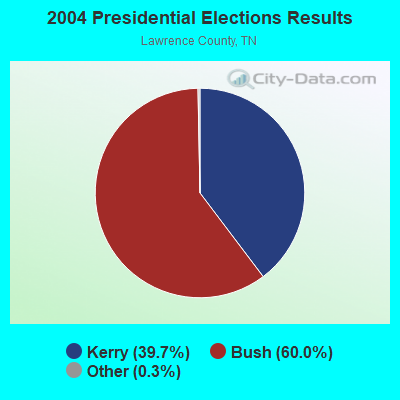
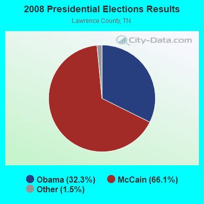
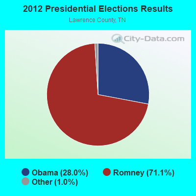
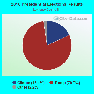
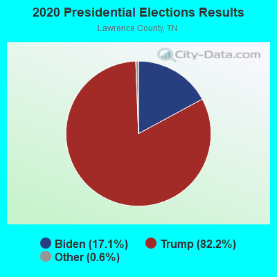
Graphs represent county-level data. Detailed 2008 Election Results
Religion statistics for Deerfield, TN (based on Lawrence County data)
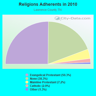
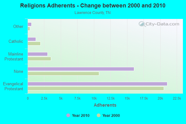
| Religion | Adherents | Congregations |
|---|---|---|
| Evangelical Protestant | 21,055 | 106 |
| Mainline Protestant | 3,005 | 21 |
| Catholic | 1,200 | 3 |
| Other | 563 | 2 |
| None | 16,046 | - |
Food Environment Statistics:
| Here: | 2.20 / 10,000 pop. |
| Tennessee: | 1.99 / 10,000 pop. |
| Lawrence County: | 0.24 / 10,000 pop. |
| Tennessee: | 0.17 / 10,000 pop. |
| This county: | 1.71 / 10,000 pop. |
| Tennessee: | 0.65 / 10,000 pop. |
| This county: | 7.58 / 10,000 pop. |
| Tennessee: | 5.16 / 10,000 pop. |
| Here: | 4.65 / 10,000 pop. |
| Tennessee: | 6.56 / 10,000 pop. |
| Here: | 13.0% |
| Tennessee: | 11.4% |
| Lawrence County: | 30.3% |
| Tennessee: | 30.2% |
| This county: | 11.9% |
| Tennessee: | 13.5% |
Strongest AM radio stations in Deerfield:
- WSM (650 AM; 50 kW; NASHVILLE, TN; Owner: GAYLORD ENTERTAINMENT COMPANY)
- WZNN (620 AM; 5 kW; LEXINGTON, AL; Owner: MANUEL HUERTA)
- WLOR (1550 AM; 50 kW; HUNTSVILLE, AL; Owner: BCA RADIO, LLC)
- WKDA (1200 AM; 50 kW; NASHVILLE, TN; Owner: RADIO NASHVILLE, INC.)
- WAMB (1160 AM; 50 kW; DONELSON, TN; Owner: GREAT SOUTHERN BROADCASTING COMPANY, INC.)
- WNQM (1300 AM; 50 kW; NASHVILLE, TN; Owner: WNQM. INC.)
- WWLX (590 AM; 1 kW; LAWRENCEBURG, TN; Owner: PROSPECT COMMUNICATIONS)
- WVNN (770 AM; 10 kW; ATHENS, AL; Owner: ATHENS BROADCASTING COMPANY, INC.)
- WLAC (1510 AM; 50 kW; NASHVILLE, TN; Owner: CAPSTAR TX LIMITED PARTNERSHIP)
- WDXE (1370 AM; 1 kW; LAWRENCEBURG, TN; Owner: LAKEWOOD COMMUNICATIONS LLC)
- WWAM (820 AM; daytime; 50 kW; JASPER, TN; Owner: SHELTON BROADCASTING SYSTEM)
- WBXR (1140 AM; daytime; 15 kW; HAZEL GREEN, AL; Owner: LOW COUNTRY CORPORATION, INC.)
- WCRV (640 AM; 50 kW; COLLIERVILLE, TN; Owner: BOTT BROADCASTING COMPANY/TENNESSEE)
Strongest FM radio stations in Deerfield:
- W287AA (105.3 FM; LAWRENCEBURG, TN; Owner: WAY-FM MEDIA GROUP, INC.)
- WDXE-FM (106.7 FM; LAWRENCEBURG, TN; Owner: LAKEWOOD COMMUNICATIONS LLC)
- WLLX (97.5 FM; LAWRENCEBURG, TN; Owner: ROGER WRIGHT DBA PROSPECT COMMUNICATIONS)
- WMSR-FM (94.9 FM; COLLINWOOD, TN; Owner: OHIO BROADCAST ASSOCIATES)
- WEUZ (92.1 FM; MINOR HILL, TN; Owner: BROADCAST ONE, INC.)
- WLAY-FM (100.3 FM; TUSCUMBIA, AL; Owner: CLEAR CHANNEL BROADCASTING LICENSES, INC.)
- WJOR-FM (101.5 FM; ST. JOSEPH, TN; Owner: CLEAR CHANNEL BROADCASTING LICENSES, INC.)
- WAWI (89.7 FM; LAWRENCEBURG, TN; Owner: AMERICAN FAMILY ASSOCIATION)
- WFGZ (94.5 FM; LOBELVILLE, TN; Owner: OHIO BROADCAST ASSOCIATES)
- WDNX (89.1 FM; OLIVE HILL, TN; Owner: RURAL LIFE FOUNDATION, INC)
- WYTK (93.9 FM; ROGERSVILLE, AL; Owner: SHOALS BROADCASTING CORPORATION)
- W254AA (98.7 FM; COLBERT HEIGHTS, AL; Owner: WILLIAM P. ROGERS)
- WAUO (90.7 FM; HOHENWALD, TN; Owner: AMERICAN FAMILY ASSOCIATION)
- W209AT (89.7 FM; HOHENWALD, TN; Owner: AMERICAN FAMILY ASSOCIATION)
- W226AF (93.1 FM; LORETTO, TN; Owner: PROSPECT COMMUNICATIONS)
- W263AR (100.5 FM; LAWRENCEBURG, TN; Owner: PROSPECT COMMUNICATIONS)
TV broadcast stations around Deerfield:
- W10BV (Channel 10; LAWRENCEBURG, TN; Owner: ETC COMMUNICATIONS INC.)
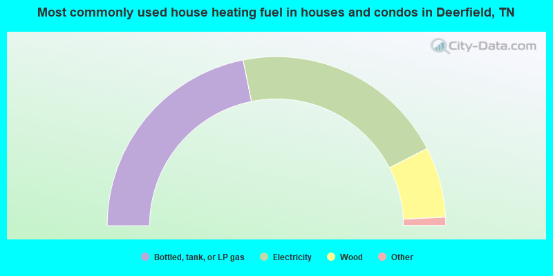
- 43.7%Bottled, tank, or LP gas
- 41.2%Electricity
- 13.5%Wood
- 0.9%Fuel oil, kerosene, etc.
- 0.7%No fuel used
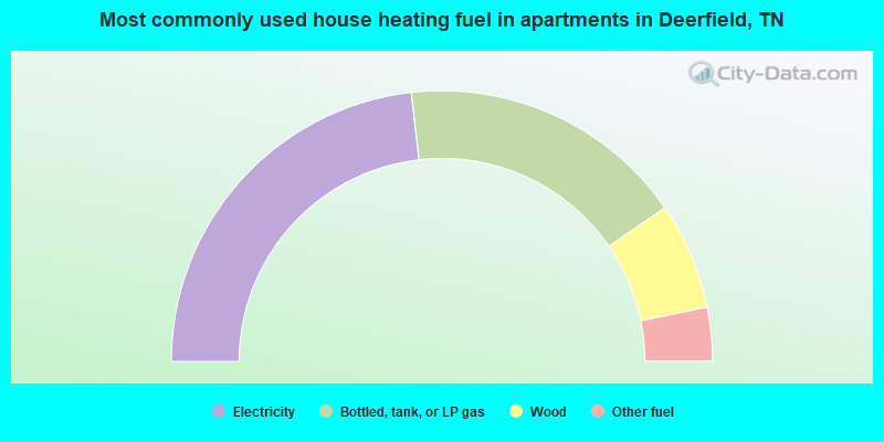
- 46.4%Electricity
- 34.4%Bottled, tank, or LP gas
- 12.8%Wood
- 6.4%Other fuel
Deerfield compared to Tennessee state average:
- Median house value below state average.
- Black race population percentage significantly below state average.
- Hispanic race population percentage significantly below state average.
- Foreign-born population percentage significantly below state average.
- Renting percentage significantly below state average.
- Length of stay since moving in significantly above state average.
- Number of rooms per house significantly below state average.
- House age significantly below state average.
- Number of college students below state average.
- Percentage of population with a bachelor's degree or higher significantly below state average.