Decatur, Wisconsin
Submit your own pictures of this town and show them to the world
- OSM Map
- Google Map
- MSN Map
Population change since 2000: +4.7%
 |
| Males: 905 | |
| Females: 862 |
| Median resident age: | 44.9 years |
| Wisconsin median age: | 42.6 years |
Zip codes: 53520.
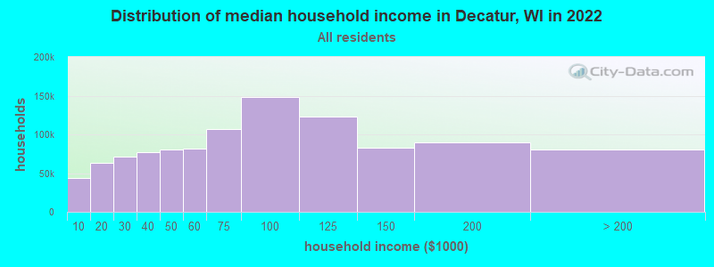
| Decatur: | $87,618 |
| WI: | $70,996 |
Estimated per capita income in 2022: $38,424 (it was $19,482 in 2000)
Decatur town income, earnings, and wages data
Estimated median house or condo value in 2022: $290,391 (it was $125,800 in 2000)
| Decatur: | $290,391 |
| WI: | $252,800 |
Mean prices in 2022: all housing units: $276,735; detached houses: $288,797; townhouses or other attached units: $225,998; in 2-unit structures: $159,956; in 3-to-4-unit structures: $270,967; mobile homes: $33,629
Detailed information about poverty and poor residents in Decatur, WI
Compare current foreclosures near Decatur, WI:
| Photo | Address | Area | Beds / Baths | Price | Details |
|---|---|---|---|---|---|

|
#1
11th Ave
Monroe, WI 53566
|
905 sq. feet
|
1 baths 2 beds |
$116,600
|
show details |

|
#2
W 2nd Ave
Brodhead, WI 53520
|
1,052 sq. feet
|
1 baths 3 beds |
show details | |

|
#3
Golf Course Rd
Brodhead, WI 53520
|
- sq. feet
|
- baths - beds |
show details | |

|
#4
S 7th St
Evansville, WI 53536
|
- sq. feet
|
- baths - beds |
show details | |

|
#5
2nd St # 999
New Glarus, WI 53574
|
- sq. feet
|
- baths - beds |
show details | |

|
#6
W Hickory Hls
Beloit, WI 53511
|
- sq. feet
|
- baths - beds |
show details | |

|
#7
W 21st St Lot 61
Monroe, WI 53566
|
- sq. feet
|
- baths - beds |
show details | |

|
#8
Noahs Arc Ct
Evansville, WI 53536
|
- sq. feet
|
- baths - beds |
show details | |

|
#9
Countryside Dr Apt 3
Evansville, WI 53536
|
- sq. feet
|
- baths - beds |
show details | |

|
#10
N County Road M Lot 64
Evansville, WI 53536
|
- sq. feet
|
- baths - beds |
show details |
| Photo | Address | Area | Beds / Baths | Price | Details |
|---|---|---|---|---|---|

|
#11
Garfield Ave
Evansville, WI 53536
|
- sq. feet
|
- baths - beds |
show details | |

|
#12
Iliff Rd
Monroe, WI 53566
|
- sq. feet
|
- baths - beds |
show details | |

|
#13
Bike Trail Ln
Brodhead, WI 53520
|
- sq. feet
|
- baths - beds |
show details | |

|
#14
N Windmill Ridge Rd
Evansville, WI 53536
|
- sq. feet
|
- baths - beds |
show details | |

|
#15
12th Ave Apt 3
Monroe, WI 53566
|
- sq. feet
|
- baths - beds |
show details | |

|
#16
Theiler Rd
Juda, WI 53550
|
- sq. feet
|
- baths - beds |
show details | |

|
#17
Airport Rd
Brodhead, WI 53520
|
- sq. feet
|
- baths - beds |
show details | |

|
#18
Crazy Horse Ln, Lot 9
Brodhead, WI 53520
|
- sq. feet
|
- baths - beds |
show details | |

|
#19
19th St, Trlr 28
Brodhead, WI 53520
|
- sq. feet
|
- baths - beds |
show details | |

|
#20
21st St, Trlr 69
Brodhead, WI 53520
|
- sq. feet
|
- baths - beds |
show details |
| Photo | Address | Area | Beds / Baths | Price | Details |
|---|---|---|---|---|---|

|
#21
W Main St Apt 306
Albany, WI 53502
|
- sq. feet
|
- baths - beds |
show details | |

|
#22
E High St # 1
Orangeville, IL 61060
|
- sq. feet
|
- baths - beds |
show details | |

|
#23
Norwegian Rd
Albany, WI 53502
|
- sq. feet
|
- baths - beds |
show details | |

|
#24
15th St
Monroe, WI 53566
|
- sq. feet
|
- baths - beds |
show details | |

|
#25
N Riley Rd
Evansville, WI 53536
|
- sq. feet
|
- baths - beds |
show details | |

|
#26
Forest Preserve Rd
Durand, IL 61024
|
- sq. feet
|
- baths - beds |
show details | |

|
#27
Concord Dr
Durand, IL 61024
|
- sq. feet
|
- baths - beds |
show details | |

|
#28
Highview Ct
Orangeville, IL 61060
|
- sq. feet
|
- baths - beds |
show details | |

|
#29
Lorimar Dr
Durand, IL 61024
|
- sq. feet
|
- baths - beds |
show details | |

|
#30
Lorimar Dr
Durand, IL 61024
|
- sq. feet
|
- baths - beds |
show details |
| Photo | Address | Area | Beds / Baths | Price | Details |
|---|---|---|---|---|---|

|
#31
Vine St
Belleville, WI 53508
|
- sq. feet
|
- baths - beds |
show details | |

|
#32
30 1/2 Ave
Monroe, WI 53566
|
- sq. feet
|
- baths - beds |
show details | |

|
#33
N Lee St
Davis, IL 61019
|
- sq. feet
|
- baths - beds |
show details | |

|
#34
E Main St
Durand, IL 61024
|
- sq. feet
|
- baths - beds |
show details | |

|
#35
Hauley Rd
Rockton, IL 61072
|
- sq. feet
|
- baths - beds |
show details | |

|
#36
E Exchange St
Brodhead, WI 53520
|
- sq. feet
|
- baths - beds |
show details | |

|
#37
Southgate Dr
Davis, IL 61019
|
- sq. feet
|
- baths - beds |
show details | |

|
#38
Gainsboro Rd
Davis, IL 61019
|
- sq. feet
|
- baths - beds |
show details | |

|
#39
S 2nd St
Evansville, WI 53536
|
- sq. feet
|
- baths - beds |
show details | |

|
#40
E Rock Grove Rd
Rock City, IL 61070
|
- sq. feet
|
- baths - beds |
show details |
| Photo | Address | Area | Beds / Baths | Price | Details |
|---|---|---|---|---|---|

|
#41
W 6th Ave
Brodhead, WI 53520
|
- sq. feet
|
- baths - beds |
show details | |

|
#42
S 6th St
Evansville, WI 53536
|
- sq. feet
|
- baths - beds |
show details | |

|
#43
S 6th St
Evansville, WI 53536
|
- sq. feet
|
- baths - beds |
show details | |

|
#44
E 4th Ave
Brodhead, WI 53520
|
- sq. feet
|
- baths - beds |
show details | |

|
#45
23rd St
Monroe, WI 53566
|
- sq. feet
|
- baths - beds |
show details | |

|
#46
12th St
Monroe, WI 53566
|
- sq. feet
|
- baths - beds |
show details | |

|
#47
N Coon Island Rd
Evansville, WI 53536
|
- sq. feet
|
- baths - beds |
show details | |

|
#48
19th St
Monroe, WI 53566
|
- sq. feet
|
- baths - beds |
show details | |

|
#49
W Lang Rd
Orfordville, WI 53576
|
- sq. feet
|
- baths - beds |
show details | |

|
Check over 1 million property listings on Foreclosure.com!
|
browse all offers | |||

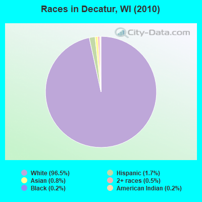
- 1,70696.5%White alone
- 301.7%Hispanic
- 150.8%Asian alone
- 90.5%Two or more races
- 30.2%Black alone
- 30.2%American Indian alone
- 10.06%Other race alone
Races in Decatur detailed stats: ancestries, foreign born residents, place of birth
According to our research of Wisconsin and other state lists, there was 1 registered sex offender living in Decatur, Wisconsin as of May 11, 2024.
The ratio of all residents to sex offenders in Decatur is 1,767 to 1.
The ratio of registered sex offenders to all residents in this city is much lower than the state average.
 Recent articles from our blog. Our writers, many of them Ph.D. graduates or candidates, create easy-to-read articles on a wide variety of topics.
Ancestries: German (41.9%), Norwegian (16.6%), Swiss (16.2%), English (10.4%), Irish (9.4%), United States (7.0%).
Current Local Time: CST time zone
Land area: 34.2 square miles.
Population density: 52 people per square mile (very low).
13 residents are foreign born
| This town: | 0.8% |
| Wisconsin: | 3.6% |
| Decatur town: | 1.6% ($1,995) |
| Wisconsin: | 2.0% ($2,245) |
Nearest city with pop. 50,000+: Janesville, WI  (21.1 miles , pop. 59,498).
Nearest city with pop. 200,000+: Madison, WI (29.9 miles , pop. 208,054).
Nearest city with pop. 1,000,000+: Chicago, IL (105.4 miles , pop. 2,896,016).
Nearest cities:
), ), ), ), ), )Latitude: 42.64 N, Longitude: 89.43 W
Area code commonly used in this area: 608
| Here: | 2.0% |
| Wisconsin: | 2.7% |
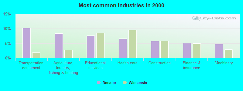
- Transportation equipment (10.3%)
- Agriculture, forestry, fishing & hunting (8.4%)
- Educational services (7.7%)
- Health care (6.7%)
- Construction (5.8%)
- Finance & insurance (5.1%)
- Machinery (4.7%)
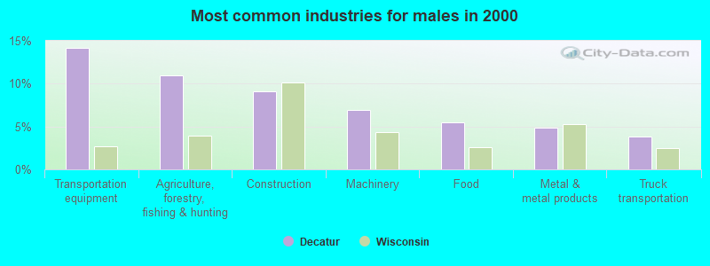
- Transportation equipment (14.2%)
- Agriculture, forestry, fishing & hunting (11.0%)
- Construction (9.1%)
- Machinery (7.0%)
- Food (5.5%)
- Metal & metal products (4.9%)
- Truck transportation (3.8%)
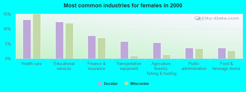
- Health care (13.1%)
- Educational services (12.4%)
- Finance & insurance (7.8%)
- Transportation equipment (5.8%)
- Agriculture, forestry, fishing & hunting (5.3%)
- Public administration (3.6%)
- Food & beverage stores (3.6%)
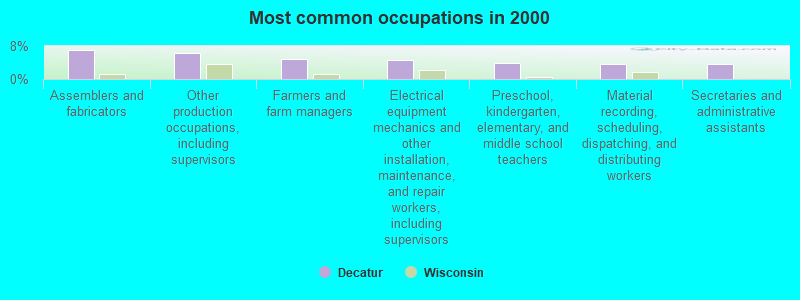
- Assemblers and fabricators (7.1%)
- Other production occupations, including supervisors (6.3%)
- Farmers and farm managers (4.9%)
- Electrical equipment mechanics and other installation, maintenance, and repair workers, including supervisors (4.6%)
- Preschool, kindergarten, elementary, and middle school teachers (3.8%)
- Material recording, scheduling, dispatching, and distributing workers (3.7%)
- Secretaries and administrative assistants (3.7%)
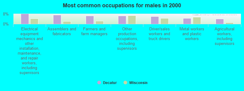
- Electrical equipment mechanics and other installation, maintenance, and repair workers, including supervisors (8.0%)
- Assemblers and fabricators (7.2%)
- Farmers and farm managers (6.6%)
- Other production occupations, including supervisors (6.6%)
- Driver/sales workers and truck drivers (6.1%)
- Metal workers and plastic workers (4.7%)
- Agricultural workers, including supervisors (4.2%)

- Secretaries and administrative assistants (8.0%)
- Assemblers and fabricators (7.0%)
- Preschool, kindergarten, elementary, and middle school teachers (6.6%)
- Other production occupations, including supervisors (6.1%)
- Other office and administrative support workers, including supervisors (5.3%)
- Other teachers, instructors, education, training, and library occupations (3.9%)
- Material recording, scheduling, dispatching, and distributing workers (3.6%)
Average climate in Decatur, Wisconsin
Based on data reported by over 4,000 weather stations


Tornado activity:
Decatur-area historical tornado activity is slightly above Wisconsin state average. It is 60% greater than the overall U.S. average.
On 6/7/1984, a category F5 (max. wind speeds 261-318 mph) tornado 36.0 miles away from the Decatur town center killed 9 people and injured 200 people and caused between $50,000 and $500,000 in damages.
On 1/24/1967, a category F3 (max. wind speeds 158-206 mph) tornado 4.2 miles away from the town center caused between $50,000 and $500,000 in damages.
Earthquake activity:
Decatur-area historical earthquake activity is significantly above Wisconsin state average. It is 52% greater than the overall U.S. average.On 4/18/2008 at 09:36:59, a magnitude 5.4 (5.1 MB, 4.8 MS, 5.4 MW, 5.2 MW, Class: Moderate, Intensity: VI - VII) earthquake occurred 301.0 miles away from Decatur center
On 6/28/2004 at 06:10:52, a magnitude 4.2 (4.2 MW, Depth: 6.2 mi, Class: Light, Intensity: IV - V) earthquake occurred 86.2 miles away from the city center
On 6/10/1987 at 23:48:54, a magnitude 5.1 (4.9 MB, 4.4 MS, 4.6 MS, 5.1 LG) earthquake occurred 276.5 miles away from the city center
On 4/18/2008 at 09:36:59, a magnitude 5.2 (5.2 MW, Depth: 8.9 mi) earthquake occurred 301.0 miles away from the city center
On 2/10/2010 at 09:59:35, a magnitude 3.8 (3.8 MW, Depth: 6.2 mi, Class: Light, Intensity: II - III) earthquake occurred 66.6 miles away from Decatur center
On 6/18/2002 at 17:37:15, a magnitude 5.0 (4.3 MB, 4.6 MW, 5.0 LG) earthquake occurred 333.6 miles away from Decatur center
Magnitude types: regional Lg-wave magnitude (LG), body-wave magnitude (MB), surface-wave magnitude (MS), moment magnitude (MW)
Natural disasters:
The number of natural disasters in Green County (16) is near the US average (15).Major Disasters (Presidential) Declared: 12
Emergencies Declared: 4
Causes of natural disasters: Floods: 10, Storms: 9, Tornadoes: 5, Winter Storms: 2, Drought: 1, Hurricane: 1, Snow: 1, Snowstorm: 1, Wind: 1, Other: 1 (Note: some incidents may be assigned to more than one category).
Hospitals and medical centers near Decatur:
- MONROE MNR NUR REHAB (Nursing Home, about 11 miles away; MONROE, WI)
- MONROE CLINIC DIALYSIS (Dialysis Facility, about 11 miles away; MONROE, WI)
- THE MONROE CLINIC HOME CARE (Home Health Center, about 11 miles away; MONROE, WI)
- THE MONROE CLINIC Acute Care Hospitals (about 11 miles away; MONROE, WI)
- EVANSVILLE MANOR (Nursing Home, about 12 miles away; EVANSVILLE, WI)
- MEDINA NURSING CENTER (Nursing Home, about 16 miles away; DURAND, IL)
Colleges/universities with over 2000 students nearest to Decatur:
- Edgewood College (about 29 miles; Madison, WI; Full-time enrollment: 2,455)
- University of Wisconsin Colleges (about 30 miles; Madison, WI; FT enrollment: 10,019)
- University of Wisconsin-Madison (about 30 miles; Madison, WI; FT enrollment: 34,621)
- Rock Valley College (about 32 miles; Rockford, IL; FT enrollment: 6,269)
- Madison Area Technical College (about 34 miles; Madison, WI; FT enrollment: 9,603)
- Herzing University-Madison (about 36 miles; Madison, WI; FT enrollment: 3,160)
- University of Wisconsin-Whitewater (about 38 miles; Whitewater, WI; FT enrollment: 11,124)
Points of interest:
Notable location: County of Green Landfill (A). Display/hide its location on the map
Church in Decatur: Gap Church (A). Display/hide its location on the map
Cemeteries: Decatur Cemetery (1), Moores Cemetery (2). Display/hide their locations on the map
Reservoir: Decatur Lake (A). Display/hide its location on the map
Streams, rivers, and creeks: Riley School Branch (A), Juda Branch (B), Searles Creek (C), Norwegian Creek (D). Display/hide their locations on the map
Park in Decatur: Ward Swartz Decatur Woods State Natural Area (1). Display/hide its location on the map
| This town: | 2.6 people |
| Wisconsin: | 2.4 people |
| This town: | 81.7% |
| Whole state: | 64.4% |
| This town: | 4.7% |
| Whole state: | 7.3% |
Likely homosexual households (counted as self-reported same-sex unmarried-partner households)
- Lesbian couples: 0.3% of all households
- Gay men: 0.0% of all households
| This town: | 5.1% |
| Whole state: | 8.7% |
| This town: | 3.2% |
| Whole state: | 3.7% |
9 people in homes for the mentally ill in 2000
For population 15 years and over in Decatur:
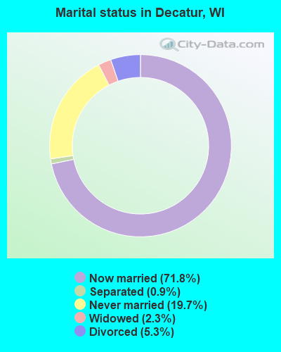
- Never married: 19.7%
- Now married: 71.8%
- Separated: 0.9%
- Widowed: 2.3%
- Divorced: 5.3%
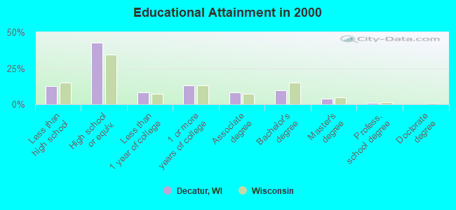
For population 25 years and over in Decatur:
- High school or higher: 87.3%
- Bachelor's degree or higher: 15.0%
- Graduate or professional degree: 5.4%
- Unemployed: 3.7%
- Mean travel time to work (commute): 26.4 minutes
| Here: | 9.4 |
| Wisconsin average: | 11.0 |
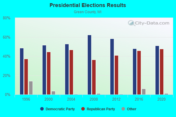
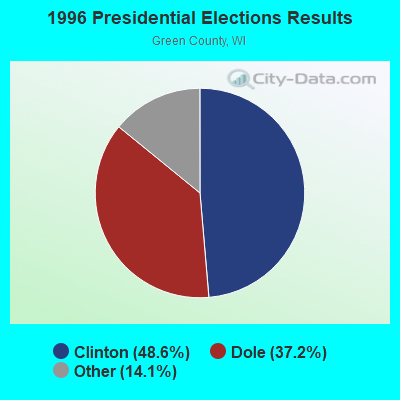
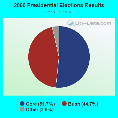
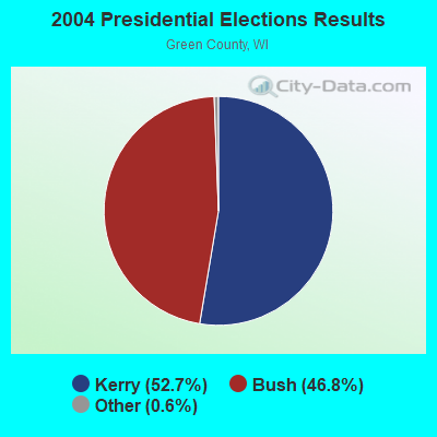
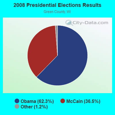
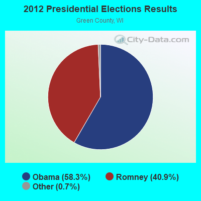
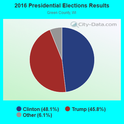
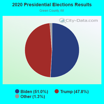
Graphs represent county-level data. Detailed 2008 Election Results
Religion statistics for Decatur, WI (based on Green County data)
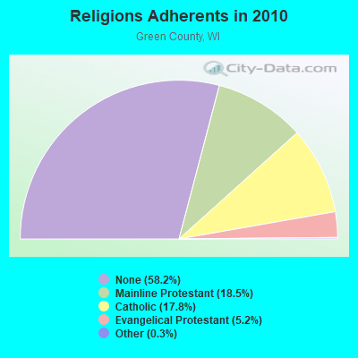
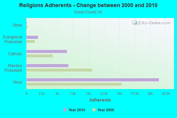
| Religion | Adherents | Congregations |
|---|---|---|
| Mainline Protestant | 6,822 | 20 |
| Catholic | 6,560 | 4 |
| Evangelical Protestant | 1,922 | 17 |
| Other | 112 | 6 |
| None | 21,426 | - |
Food Environment Statistics:
| Green County: | 2.24 / 10,000 pop. |
| State: | 1.86 / 10,000 pop. |
| Green County: | 0.28 / 10,000 pop. |
| Wisconsin: | 0.38 / 10,000 pop. |
| Green County: | 4.20 / 10,000 pop. |
| Wisconsin: | 4.12 / 10,000 pop. |
| Green County: | 8.96 / 10,000 pop. |
| Wisconsin: | 8.64 / 10,000 pop. |
| This county: | 7.3% |
| Wisconsin: | 7.6% |
| Here: | 26.9% |
| Wisconsin: | 27.5% |
| Green County: | 24.3% |
| Wisconsin: | 13.0% |
Strongest AM radio stations in Decatur:
- WTMJ (620 AM; 50 kW; MILWAUKEE, WI; Owner: JOURNAL BROADCAST CORPORATION)
- WTSO (1070 AM; 10 kW; MADISON, WI; Owner: CAPSTAR TX LIMITED PARTNERSHIP)
- WLMV (1480 AM; 10 kW; MADISON, WI; Owner: MID-WEST MANAGEMENT, INC.)
- WSCR (670 AM; 50 kW; CHICAGO, IL; Owner: INFINITY BROADCASTING OPERATIONS, INC.)
- WEKZ (1260 AM; 1 kW; MONROE, WI; Owner: RONALD M. SPIELMAN & SCOTT THOMPSON)
- WGN (720 AM; 50 kW; CHICAGO, IL; Owner: WGN CONTINENTAL BROADCASTING CO.)
- WISN (1130 AM; 50 kW; MILWAUKEE, WI; Owner: CAPSTAR TX LIMITED PARTNERSHIP)
- WTDY (1670 AM; 10 kW; MADISON, WI; Owner: MID-WEST MANAGEMENT, INC.)
- WBBM (780 AM; 50 kW; CHICAGO, IL; Owner: INFINITY BROADCASTING OPERATIONS, INC.)
- WHA (970 AM; 5 kW; MADISON, WI; Owner: BOARD REGENTS OF UNIV OF WI SYSTEM)
- WTJK (1380 AM; 5 kW; SOUTH BELOIT, IL; Owner: GOOD KARMA BROADCASTING, L.L.C.)
- WIBA (1310 AM; 5 kW; MADISON, WI; Owner: CAPSTAR TX LIMITED PARTNERSHIP)
- WMVP (1000 AM; 50 kW; CHICAGO, IL; Owner: ABC, INC.)
Strongest FM radio stations in Decatur:
- WKPO (105.9 FM; EVANSVILLE, WI; Owner: GOOD KARMA BROADCASTING, L.L.C.)
- WEKZ-FM (93.7 FM; MONROE, WI; Owner: RONALD M.SPIELMAN & SCOTT THOMPSON)
- WJVL (99.9 FM; JANESVILLE, WI; Owner: SOUTHERN WISCONSIN BROADCASTING, L.L.C.)
- WERN (88.7 FM; MADISON, WI; Owner: STATE OF WISCONSIN - EDUCATIONAL COMMUNICATIONS BOARD)
- WZEE (104.1 FM; MADISON, WI; Owner: CAPSTAR TX LIMITED PARTNERSHIP)
- WIBA-FM (101.5 FM; MADISON, WI; Owner: CAPSTAR TX LIMITED PARTNERSHIP)
- WSJY (107.3 FM; FORT ATKINSON, WI; Owner: NEWRADIO GROUP, LLC)
- WORT (89.9 FM; MADISON, WI; Owner: BACK PORCH RADIO BROADCASTING, INC.)
- WMGN (98.1 FM; MADISON, WI; Owner: MID-WEST MANAGEMENT, INC.)
- WMMM-FM (105.5 FM; VERONA, WI; Owner: ENTERCOM MADISON LICENSE, LLC.)
- WNIE (89.1 FM; FREEPORT, IL; Owner: NORTHERN ILLINOIS UNIVERSITY)
- WFEN (88.3 FM; ROCKFORD, IL; Owner: FAITH ACADEMY, DBA WFEN)
- WKMQ-FM (96.7 FM; LOVES PARK, IL; Owner: CUMULUS LICENSING CORP.)
- WXXQ (98.5 FM; FREEPORT, IL; Owner: CUMULUS LICENSING CORP.)
- WGFB (103.1 FM; ROCKTON, IL; Owner: WRWC, Inc.)
- WSUM (91.7 FM; MADISON, WI; Owner: BD. OF REGENTS OF UNIVERSITY OF WISCONSIN SYSTEM)
- W215AQ (90.9 FM; MADISON, WI; Owner: STATE OF WISCONSIN - EDUCATIONAL COMMUNICATIONS BOARD)
- WYHY (95.3 FM; WINNEBAGO, IL; Owner: AIRPLAY BROADCASTING CORPORATION)
- WGSL (91.1 FM; LOVES PARK, IL; Owner: CHRISTIAN LIFE CENTER SCHOOL)
- WNWC-FM (102.5 FM; MADISON, WI; Owner: NORTHWESTERN COLLEGE)
TV broadcast stations around Decatur:
- WISC-TV (Channel 3; MADISON, WI; Owner: TELEVISION WISCONSIN, INC.)
- WMSN-TV (Channel 47; MADISON, WI; Owner: WMSN LICENSEE, LLC)
- WKOW-TV (Channel 27; MADISON, WI; Owner: WKOW TELEVISION, INC.)
- WHA-TV (Channel 21; MADISON, WI; Owner: BOARD OF REGENTS OF THE UNIV. OF WISCONSIN SYSTEM)
- WMTV (Channel 15; MADISON, WI; Owner: GRAY MIDAMERICA TV LICENSEE CORP.)
- W65EE (Channel 65; JANESVILLE, WI; Owner: TRINITY BROADCASTING NETWORK)
- WIFR (Channel 23; FREEPORT, IL; Owner: GRAY MIDAMERICA TV LICENSEE CORP.)
- WTVO (Channel 17; ROCKFORD, IL; Owner: WINNEBAGO TELEVISION CORPORATION)
- WFBN-LP (Channel 33; ROCKFORD, IL; Owner: WEIGEL BROADCASTING COMPANY)
- WREX-TV (Channel 13; ROCKFORD, IL; Owner: WREX TELEVISION, LLC)
- WQRF-TV (Channel 39; ROCKFORD, IL; Owner: QUORUM OF ROCKFORD LICENSE, LLC)
- W38CT (Channel 38; MADISON, WI; Owner: TRINITY BROADCASTING NETWORK)
- W23BW (Channel 23; MADISON, WI; Owner: THREE ANGELS BROADCASTING NETWORK)
- National Bridge Inventory (NBI) Statistics
- 11Number of bridges
- 95ft / 29.2mTotal length
- 3,780Total average daily traffic
- 100Total average daily truck traffic
- 4,152Total future (year 2039) average daily traffic
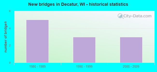
- New bridges - historical statistics
- 51980-1989
- 31990-1999
- 32000-2009
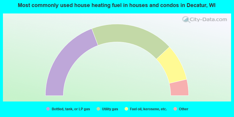
- 38.5%Bottled, tank, or LP gas
- 37.6%Utility gas
- 16.5%Fuel oil, kerosene, etc.
- 3.9%Wood
- 3.4%Electricity
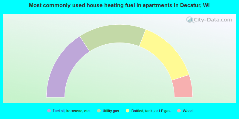
- 31.7%Fuel oil, kerosene, etc.
- 30.0%Utility gas
- 28.3%Bottled, tank, or LP gas
- 10.0%Wood
Decatur compared to Wisconsin state average:
- Unemployed percentage significantly below state average.
- Black race population percentage significantly below state average.
- Hispanic race population percentage significantly below state average.
- Foreign-born population percentage significantly below state average.
- Renting percentage significantly below state average.
- Length of stay since moving in significantly above state average.
- Number of rooms per house significantly below state average.
- House age significantly below state average.
- Number of college students below state average.
- Percentage of population with a bachelor's degree or higher below state average.