Danville, Alabama
Submit your own pictures of this place and show them to the world
- OSM Map
- General Map
- Google Map
- MSN Map

| Males: 3,101 | |
| Females: 3,141 |
| Median resident age: | 35.0 years |
| Alabama median age: | 35.8 years |
Zip code: 35640
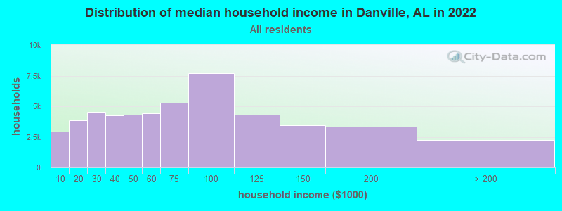
| Danville: | $64,118 |
| AL: | $59,674 |
Estimated per capita income in 2022: $28,139 (it was $16,743 in 2000)
Danville CCD income, earnings, and wages data
Estimated median house or condo value in 2022: $192,121 (it was $76,700 in 2000)
| Danville: | $192,121 |
| AL: | $200,900 |
Detailed information about poverty and poor residents in Danville, AL
Compare current foreclosures near Danville, AL:
| Photo | Address | Area | Beds / Baths | Price | Details |
|---|---|---|---|---|---|

|
#1
County Road 72
Danville, AL 35619
|
- sq. feet
|
- baths - beds |
show details | |

|
#2
Liberty Rd
Danville, AL 35619
|
- sq. feet
|
- baths - beds |
show details | |

|
#3
County Road 209
Danville, AL 35619
|
- sq. feet
|
- baths - beds |
show details | |

|
#4
Liberty Rd
Danville, AL 35619
|
1,616 sq. feet
|
- baths - beds |
show details | |

|
#5
County Road 81
Danville, AL 35619
|
- sq. feet
|
- baths - beds |
show details | |

|
#6
County Road 205
Danville, AL 35619
|
- sq. feet
|
- baths - beds |
show details | |

|
#7
Highway 36
Danville, AL 35619
|
- sq. feet
|
- baths - beds |
show details | |

|
#8
County Road 327
Danville, AL 35619
|
- sq. feet
|
- baths - beds |
show details | |

|
#9
Kirby Bridge Rd
Danville, AL 35619
|
- sq. feet
|
- baths - beds |
show details | |

|
#10
County Road 84
Danville, AL 35619
|
- sq. feet
|
- baths - beds |
show details |
| Photo | Address | Area | Beds / Baths | Price | Details |
|---|---|---|---|---|---|

|
#11
Highway 36
Danville, AL 35619
|
- sq. feet
|
- baths - beds |
show details | |

|
#12
County Road 204
Danville, AL 35619
|
- sq. feet
|
- baths - beds |
show details | |

|
#13
Al Highway 157
Danville, AL 35619
|
- sq. feet
|
- baths - beds |
show details | |

|
#14
County Road 1341
Vinemont, AL 35179
|
768 sq. feet
|
1 baths 2 beds |
$154,900
|
show details |

|
#15
N Greenway Dr
Trinity, AL 35673
|
1,484 sq. feet
|
2 baths 3 beds |
show details | |

|
#16
County Road 221
Moulton, AL 35650
|
1,625 sq. feet
|
2 baths 3 beds |
show details | |

|
#17
County Road 434
Trinity, AL 35673
|
1,336 sq. feet
|
2 baths 3 beds |
show details | |

|
#18
Magnolia St SE
Decatur, AL 35601
|
2,284 sq. feet
|
2 baths 3 beds |
show details | |

|
#19
County Road 170
Trinity, AL 35673
|
1,776 sq. feet
|
2 baths 3 beds |
show details | |

|
#20
County Road 99
Moulton, AL 35650
|
1,021 sq. feet
|
1 baths 3 beds |
show details |
| Photo | Address | Area | Beds / Baths | Price | Details |
|---|---|---|---|---|---|

|
#21
Count Mallard Dr SE
Decatur, AL 35601
|
1,818 sq. feet
|
2 baths 4 beds |
show details | |

|
#22
4th Ave NW
Decatur, AL 35601
|
1,642 sq. feet
|
2 baths 3 beds |
show details | |

|
#23
County Road 557
Trinity, AL 35673
|
- sq. feet
|
1 baths 3 beds |
show details | |

|
#24
Wilhite Rd
Falkville, AL 35622
|
1,451 sq. feet
|
2 baths 3 beds |
show details | |

|
#25
Market St
Moulton, AL 35650
|
1,620 sq. feet
|
2 baths 4 beds |
show details | |

|
#26
Callie Pvt Dr
Somerville, AL 35670
|
- sq. feet
|
2 baths 3 beds |
show details | |

|
#27
County Road 457
Trinity, AL 35673
|
- sq. feet
|
2 baths 3 beds |
show details | |

|
#28
Winthrop Dr SW
Decatur, AL 35603
|
1,506 sq. feet
|
2 baths 3 beds |
show details | |

|
#29
County Road 591
Trinity, AL 35673
|
- sq. feet
|
2 baths 3 beds |
show details | |

|
#30
Linwood St SW
Hartselle, AL 35640
|
1,603 sq. feet
|
2 baths 4 beds |
show details |
| Photo | Address | Area | Beds / Baths | Price | Details |
|---|---|---|---|---|---|

|
#31
Cameron St SW
Decatur, AL 35603
|
1,222 sq. feet
|
1 baths 3 beds |
show details | |

|
#32
County Road 217
Trinity, AL 35673
|
1,468 sq. feet
|
2 baths - beds |
show details | |

|
#33
Nance Ford Rd
Hartselle, AL 35640
|
- sq. feet
|
2 baths 4 beds |
show details | |

|
#34
Robinson St SW
Decatur, AL 35601
|
1,270 sq. feet
|
1 baths - beds |
show details | |

|
#35
Pavillion Pl SW
Decatur, AL 35603
|
1,421 sq. feet
|
1 baths 3 beds |
show details | |

|
#36
County Road 1139
Vinemont, AL 35179
|
- sq. feet
|
- baths 4 beds |
show details | |

|
#37
Corwin Dr
Decatur, AL 35603
|
2,115 sq. feet
|
1 baths - beds |
show details | |

|
#38
4th Ave SW
Decatur, AL 35601
|
1,566 sq. feet
|
1 baths - beds |
show details | |

|
#39
Eastbrook SE
Decatur, AL 35601
|
2,062 sq. feet
|
1 baths - beds |
show details | |

|
#40
Eastbrook SE
Decatur, AL 35601
|
1,762 sq. feet
|
1 baths - beds |
show details |
| Photo | Address | Area | Beds / Baths | Price | Details |
|---|---|---|---|---|---|

|
#41
River Bend Pl SE
Decatur, AL 35601
|
1,573 sq. feet
|
1 baths - beds |
show details | |

|
#42
County Road 368
Trinity, AL 35673
|
1,248 sq. feet
|
4 baths - beds |
show details | |

|
#43
Essex Dr SW
Decatur, AL 35603
|
1,686 sq. feet
|
1 baths - beds |
show details | |

|
#44
Bobwhite Dr SW
Decatur, AL 35601
|
1,276 sq. feet
|
1 baths - beds |
show details | |

|
#45
Weatherly Cir SW
Decatur, AL 35603
|
3,948 sq. feet
|
2 baths - beds |
show details | |

|
#46
Jefferson Ave SW
Decatur, AL 35603
|
2,219 sq. feet
|
1 baths - beds |
show details | |

|
#47
Al Highway 24
Moulton, AL 35650
|
1,575 sq. feet
|
4 baths - beds |
show details | |

|
#48
County Road 214
Trinity, AL 35673
|
1,326 sq. feet
|
4 baths - beds |
show details | |

|
#49
County Road 369
Trinity, AL 35673
|
1,635 sq. feet
|
4 baths - beds |
show details | |

|
Check over 1 million property listings on Foreclosure.com!
|
browse all offers | |||

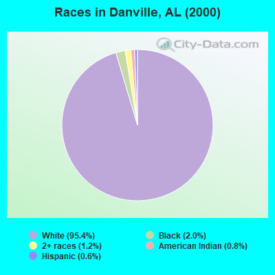
- 5,74895.4%White alone
- 1182.0%Black alone
- 721.2%Two or more races
- 490.8%American Indian alone
- 340.6%Hispanic
- 40.07%Other race alone
- 30.05%Asian alone
According to our research of Alabama and other state lists, there were 20 registered sex offenders living in Danville, Alabama as of May 04, 2024.
The ratio of all residents to sex offenders in Danville is 312 to 1.
 Recent articles from our blog. Our writers, many of them Ph.D. graduates or candidates, create easy-to-read articles on a wide variety of topics.
Current Local Time: CST time zone
Land area: 81.3 square miles.
Population density: 77 people per square mile (very low).

| Danville CCD: | 0.3% ($201) |
| Alabama: | 0.4% ($289) |
Nearest city with pop. 50,000+: Decatur, AL  (11.3 miles , pop. 53,929).
Nearest city with pop. 200,000+: Birmingham, AL (63.7 miles , pop. 242,820).
Nearest city with pop. 1,000,000+: Chicago, IL (514.0 miles , pop. 2,896,016).
Nearest cities:
), ), ), ), ), ), )Latitude: 34.43 N, Longitude: 87.05 W
Area code commonly used in this area: 256

Danville tourist attractions:
| Here: | 2.1% |
| Alabama: | 2.6% |
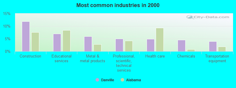
- Construction (11.9%)
- Educational services (7.0%)
- Metal & metal products (5.9%)
- Professional, scientific, technical services (5.0%)
- Health care (4.8%)
- Chemicals (4.5%)
- Transportation equipment (3.9%)
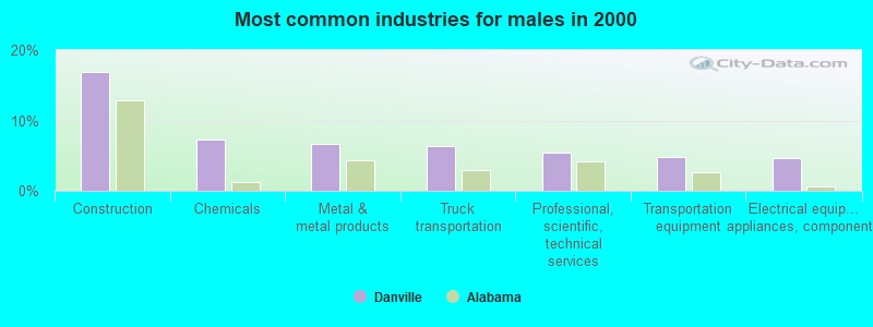
- Construction (16.9%)
- Chemicals (7.3%)
- Metal & metal products (6.7%)
- Truck transportation (6.3%)
- Professional, scientific, technical services (5.4%)
- Transportation equipment (4.8%)
- Electrical equipment, appliances, components (4.6%)
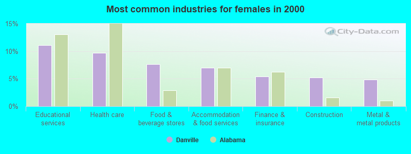
- Educational services (11.0%)
- Health care (9.7%)
- Food & beverage stores (7.7%)
- Accommodation & food services (7.0%)
- Finance & insurance (5.4%)
- Construction (5.2%)
- Metal & metal products (4.8%)
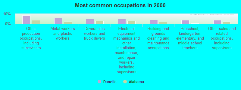
- Other production occupations, including supervisors (8.6%)
- Metal workers and plastic workers (6.2%)
- Driver/sales workers and truck drivers (4.9%)
- Electrical equipment mechanics and other installation, maintenance, and repair workers, including supervisors (4.8%)
- Building and grounds cleaning and maintenance occupations (4.0%)
- Preschool, kindergarten, elementary, and middle school teachers (3.7%)
- Other sales and related occupations, including supervisors (3.6%)
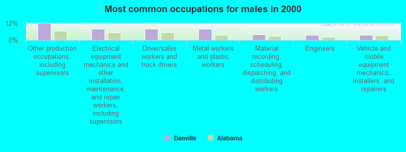
- Other production occupations, including supervisors (12.0%)
- Electrical equipment mechanics and other installation, maintenance, and repair workers, including supervisors (8.1%)
- Driver/sales workers and truck drivers (8.0%)
- Metal workers and plastic workers (7.9%)
- Material recording, scheduling, dispatching, and distributing workers (3.9%)
- Engineers (3.5%)
- Vehicle and mobile equipment mechanics, installers, and repairers (3.5%)
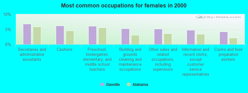
- Secretaries and administrative assistants (6.8%)
- Cashiers (6.2%)
- Preschool, kindergarten, elementary, and middle school teachers (6.1%)
- Building and grounds cleaning and maintenance occupations (5.2%)
- Other sales and related occupations, including supervisors (5.1%)
- Information and record clerks, except customer service representatives (4.7%)
- Cooks and food preparation workers (4.2%)
Average climate in Danville, Alabama
Based on data reported by over 4,000 weather stations


(lower is better)
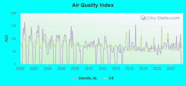
Air Quality Index (AQI) level in 2022 was 69.3. This is about average.
| City: | 69.3 |
| U.S.: | 72.6 |
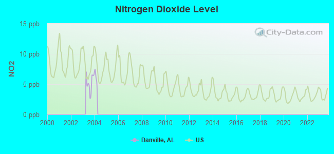
Nitrogen Dioxide (NO2) [ppb] level in 2003 was 5.26. This is about average. Closest monitor was 6.0 miles away from the city center.
| City: | 5.26 |
| U.S.: | 5.11 |
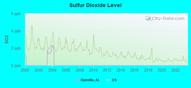
Sulfur Dioxide (SO2) [ppb] level in 2003 was 1.61. This is about average. Closest monitor was 6.0 miles away from the city center.
| City: | 1.61 |
| U.S.: | 1.51 |
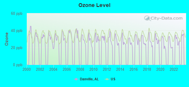
Ozone [ppb] level in 2022 was 28.9. This is about average. Closest monitor was 8.5 miles away from the city center.
| City: | 28.9 |
| U.S.: | 33.3 |
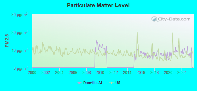
Particulate Matter (PM2.5) [µg/m3] level in 2022 was 9.10. This is about average. Closest monitor was 8.5 miles away from the city center.
| City: | 9.10 |
| U.S.: | 8.11 |
Tornado activity:
Danville-area historical tornado activity is slightly above Alabama state average. It is 166% greater than the overall U.S. average.
On 4/3/1974, a category F5 (max. wind speeds 261-318 mph) tornado 5.8 miles away from the Danville place center killed 28 people and injured 272 people.
On 4/3/1974, a category F5 tornado 19.0 miles away from the place center killed 16 people and injured 190 people.
Earthquake activity:
Danville-area historical earthquake activity is significantly above Alabama state average. It is 174% greater than the overall U.S. average.On 4/29/2003 at 08:59:39, a magnitude 4.9 (4.4 MB, 4.6 MW, 4.9 LG, Class: Light, Intensity: IV - V) earthquake occurred 80.9 miles away from the city center
On 1/18/1999 at 07:00:53, a magnitude 4.8 (4.8 MB, 4.0 LG, Depth: 0.6 mi) earthquake occurred 71.6 miles away from the city center
On 4/29/2003 at 08:59:39, a magnitude 4.6 (4.6 MW, Depth: 12.3 mi) earthquake occurred 80.9 miles away from Danville center
On 6/24/1975 at 11:11:36, a magnitude 4.5 (4.5 MB) earthquake occurred 66.8 miles away from the city center
On 3/25/1976 at 00:41:20, a magnitude 5.0 (4.9 MB, 5.0 LG, Class: Moderate, Intensity: VI - VII) earthquake occurred 203.8 miles away from the city center
On 4/18/2008 at 09:36:59, a magnitude 5.4 (5.1 MB, 4.8 MS, 5.4 MW, 5.2 MW) earthquake occurred 282.4 miles away from Danville center
Magnitude types: regional Lg-wave magnitude (LG), body-wave magnitude (MB), surface-wave magnitude (MS), moment magnitude (MW)
Natural disasters:
The number of natural disasters in Morgan County (18) is near the US average (15).Major Disasters (Presidential) Declared: 11
Emergencies Declared: 5
Causes of natural disasters: Storms: 9, Floods: 8, Tornadoes: 8, Hurricanes: 3, Winds: 3, Drought: 1, Freeze: 1, Ice Storm: 1, Snowfall: 1, Winter Storm: 1, Other: 1 (Note: some incidents may be assigned to more than one category).
Hospitals and medical centers near Danville:
- HGA HOMECARE OF DECATUR (Home Health Center, about 7 miles away; DECATUR, AL)
- SUMMERFORD NURSING HOME INC (Nursing Home, about 9 miles away; FALKVILLE, AL)
- FALKVILLE HEALTH CARE CENTER (Nursing Home, about 9 miles away; FALKVILLE, AL)
- ALACARE HOME HEALTH AND HOSPICE (Home Health Center, about 11 miles away; DECATUR, AL)
- PARKWAY MEDICAL CENTER Acute Care Hospitals (about 11 miles away; DECATUR, AL)
- DECATUR HEALTH AND REHAB CENTER (Nursing Home, about 11 miles away; DECATUR, AL)
- DECATUR MORGAN HOSPITAL-DECATUR CAMPUS Acute Care Hospitals (about 13 miles away; DECATUR, AL)
Heliports located in Danville:
Operable nuclear power plants near Danville:
- 12 miles: Browns Ferry 1 and 2 in Decatur, AL.
- 12 miles: Browns Ferry 3 in Decatur, AL.
Colleges/universities with over 2000 students nearest to Danville:
- John C Calhoun State Community College (about 17 miles; Tanner, AL; Full-time enrollment: 7,911)
- Athens State University (about 27 miles; Athens, AL; FT enrollment: 2,771)
- George C Wallace State Community College-Hanceville (about 29 miles; Hanceville, AL; FT enrollment: 4,486)
- University of Alabama in Huntsville (about 31 miles; Huntsville, AL; FT enrollment: 6,006)
- Alabama A & M University (about 37 miles; Normal, AL; FT enrollment: 4,524)
- Northwest-Shoals Community College (about 43 miles; Muscle Shoals, AL; FT enrollment: 2,702)
- Bevill State Community College (about 43 miles; Jasper, AL; FT enrollment: 2,970)
Public high school in Danville:
- DANVILLE HIGH SCH (Students: 391, Location: 9235 DANVILLE RD, Grades: 9-12)
Public elementary/middle schools in Danville:
- DANVILLE-NEEL ELEM SCH (Students: 528, Location: 8688 DANVILLE RD, Grades: PK-4)
- DANVILLE MIDDLE SCH (Students: 413, Location: 5933 HIGHWAY 36 W, Grades: 5-8)
- SPEAKE HIGH SCH (Students: 283, Location: 7323 ALABAMA HIGHWAY 36, Grades: KG-6)
Points of interest:
Notable locations in Danville: Alabama Sheriffs Boys Ranch (A), Massey Volunteer Fire Department Station 2 (B), Oak Ridge Volunteer Fire Department Station 1 (C), Punkin Center Volunteer Fire Department (D), Danville Volunteer Fire Department Station 1 (E), Neel Volunteer Fire Department (F), Danville Volunteer Fire Department Station 2 (G), Massey Volunteer Fire Department Station 1 (H), Oak Ridge Volunteer Fire Department Station 2 (I). Display/hide their locations on the map
Churches in Danville include: Forest Chapel (A), Oak Ridge Church (B), Ironman Baptist Church (C), Danville Baptist Church (D), Danville Church (E), Pumpkin Center Church (F), Neel Methodist Church (G), Neel Church of Christ (H), Upton Chapel (I). Display/hide their locations on the map
Cemeteries: O'Neal Cemetery (1), Johnson Chapel Cemetery (2), Thompson Cemetery (3), Stroup Cemetery (4), Stovall Cemetery (5), Speegle Cemetery (6), Roberts Cemetery (7). Display/hide their locations on the map
Lakes and swamps: Danville Pond (A), Goose Pond (B). Display/hide their locations on the map
Streams, rivers, and creeks: Snow Hill Branch (A), Mill Branch (B), Johnson Chapel Creek (C), Jones Creek (D), Molly Branch (E), Neel Creek (F), No Business Creek (G), Orr Creek (H), Rocky Ford Branch (I). Display/hide their locations on the map
Park in Danville: Danville-Neel Recreation Area (1). Display/hide its location on the map
| This place: | 2.6 people |
| Alabama: | 2.5 people |
| This place: | 76.9% |
| Whole state: | 67.8% |
| This place: | 4.2% |
| Whole state: | 4.7% |
Likely homosexual households (counted as self-reported same-sex unmarried-partner households)
- Lesbian couples: 0.3% of all households
- Gay men: 0.2% of all households
| This place: | 9.8% |
| Whole state: | 16.1% |
| This place: | 3.0% |
| Whole state: | 7.3% |
2 people in workers' group living quarters and job corps centers in 2010
11 people in other noninstitutional group quarters in 2000
For population 15 years and over in Danville:
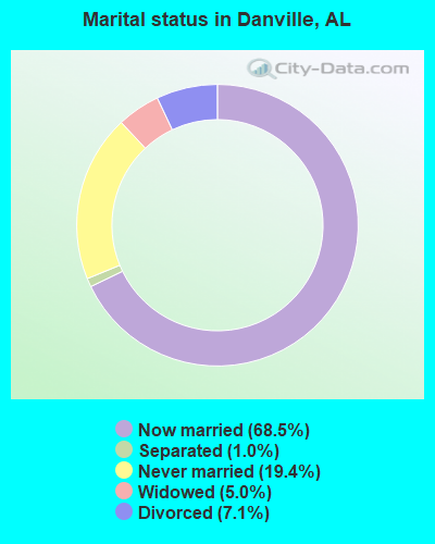
- Never married: 19.4%
- Now married: 68.5%
- Separated: 1.0%
- Widowed: 5.0%
- Divorced: 7.1%
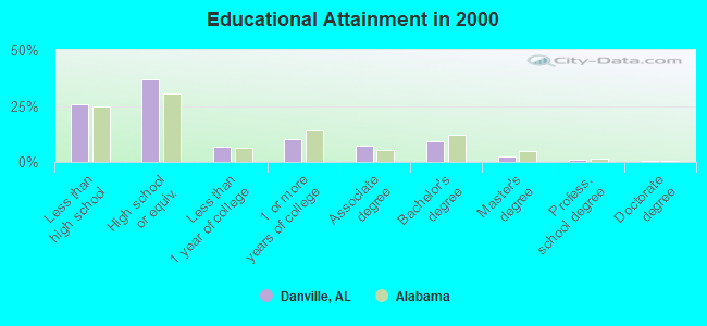
For population 25 years and over in Danville:
- High school or higher: 74.3%
- Bachelor's degree or higher: 13.0%
- Graduate or professional degree: 3.7%
- Unemployed: 5.8%
- Mean travel time to work (commute): 26.6 minutes
| Here: | 12.2 |
| Alabama average: | 13.2 |
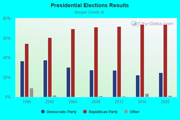
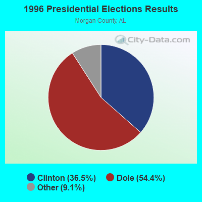
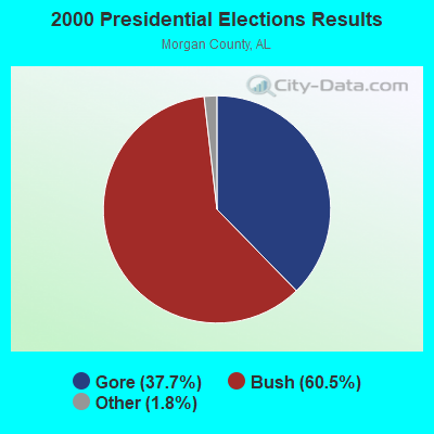

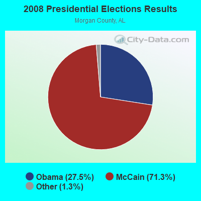


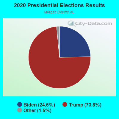
Graphs represent county-level data. Detailed 2008 Election Results
Religion statistics for Danville, AL (based on Morgan County data)
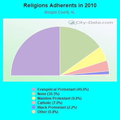
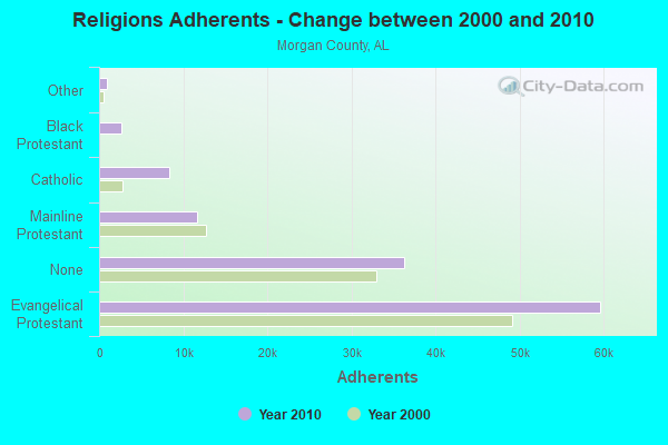
| Religion | Adherents | Congregations |
|---|---|---|
| Evangelical Protestant | 59,647 | 179 |
| Mainline Protestant | 11,687 | 46 |
| Catholic | 8,380 | 1 |
| Black Protestant | 2,605 | 19 |
| Other | 941 | 5 |
| None | 36,230 | - |
Food Environment Statistics:
| Morgan County: | 1.92 / 10,000 pop. |
| Alabama: | 1.89 / 10,000 pop. |
| Morgan County: | 0.17 / 10,000 pop. |
| Alabama: | 0.20 / 10,000 pop. |
| Here: | 0.44 / 10,000 pop. |
| Alabama: | 0.65 / 10,000 pop. |
| This county: | 7.75 / 10,000 pop. |
| Alabama: | 6.32 / 10,000 pop. |
| Morgan County: | 4.70 / 10,000 pop. |
| Alabama: | 5.75 / 10,000 pop. |
| This county: | 11.1% |
| Alabama: | 11.8% |
| Morgan County: | 35.0% |
| State: | 31.7% |
| Here: | 20.3% |
| Alabama: | 13.5% |
Strongest AM radio stations in Danville:
- WLOR (1550 AM; 50 kW; HUNTSVILLE, AL; Owner: BCA RADIO, LLC)
- WYAM (890 AM; daytime; 2 kW; HARTSELLE, AL; Owner: DECATUR COMMUNICATIONS PROPERTIES, LLC)
- WDJC (850 AM; 50 kW; BIRMINGHAM, AL; Owner: KIMTRON, INC.)
- WJOX (690 AM; 50 kW; BIRMINGHAM, AL; Owner: CITADEL BROADCASTING COMPANY)
- WVNN (770 AM; 10 kW; ATHENS, AL; Owner: ATHENS BROADCASTING COMPANY, INC.)
- WAPI (1070 AM; 50 kW; BIRMINGHAM, AL; Owner: CITADEL BROADCASTING COMPANY)
- WHIY (1190 AM; daytime; 2 kW; MOULTON, AL; Owner: HUNDLEY BATTS, SR. AND VIRGINIA CAPL)
- WDJL (1000 AM; daytime; 10 kW; HUNTSVILLE, AL; Owner: JAMES K. SHARP DBA 5TH AVE BROADCASTING)
- WMCJ (1460 AM; 5 kW; CULLMAN, AL)
- WNSI (810 AM; 50 kW; JACKSONVILLE, AL; Owner: UNITED BROADCASTING NETWORK, INC.)
- WHOS (800 AM; 1 kW; DECATUR, AL; Owner: CAPSTAR TX LIMITED PARTNERSHIP)
- WBXR (1140 AM; daytime; 15 kW; HAZEL GREEN, AL; Owner: LOW COUNTRY CORPORATION, INC.)
- WWAM (820 AM; daytime; 50 kW; JASPER, TN; Owner: SHELTON BROADCASTING SYSTEM)
Strongest FM radio stations in Danville:
- WEUP-FM (103.1 FM; MOULTON, AL; Owner: HUNDLEY BATES, SR. AND VIRGINIA CAPLES)
- WTAK-FM (106.1 FM; HARTSELLE, AL; Owner: CAPSTAR TX LIMITED PARTNERSHIP)
- W287AD (105.3 FM; HARTSELLE, AL; Owner: JEFFREY S. CHUNN)
- WYDE-FM (101.1 FM; CULLMAN, AL; Owner: KIMTRON, INC.)
- WQAH-FM (105.7 FM; ADDISON, AL; Owner: ALVIN ABERCROMBIE)
- W234AD (94.7 FM; TRINITY, AL; Owner: WILLIAM P. ROGERS)
- WRSA-FM (96.9 FM; DECATUR, AL; Owner: NCA, INC.)
- WAHR (99.1 FM; HUNTSVILLE, AL; Owner: BCA RADIO, LLC)
- W289AC (105.7 FM; HUNTSVILLE, AL; Owner: WILLIAM PAXTON ROGERS)
- WZYP (104.3 FM; ATHENS, AL; Owner: ATHENS BROADCASTING COMPANY, INC.)
- W278AA (103.5 FM; MADISON, AL; Owner: TENNESSEE VALLEY RADIO, INC.)
- WXQW (94.1 FM; MERIDIANVILLE, AL; Owner: CAPSTAR TX LIMITED PARTNERSHIP)
- WDRM (102.1 FM; DECATUR, AL; Owner: CAPSTAR TX LIMITED PARTNERSHIP)
- W293AH (106.5 FM; NORMAL, AL; Owner: CAPSTAR TX LIMITED PARTNERSHIP)
- WRTT-FM (95.1 FM; HUNTSVILLE, AL; Owner: BCA RADIO, LLC)
- W298AF (107.5 FM; HADEN, AL; Owner: HADEN RADIO COMPANY)
- W222AK (92.3 FM; HUNTSVILLE, AL; Owner: PRESS W. PARHAM)
- W249BB (97.7 FM; HUNTSVILLE, AL; Owner: WAY-FM MEDIA GROUP, INC.)
- W275AA (102.9 FM; HUNTSVILLE, AL; Owner: ARCHIE C. BOBO, PERSONAL REP. OF DORSEY E. NEWMAN ESTATE)
- W300AH (107.9 FM; HUNTSVILLE, AL; Owner: PORTER L. BATTS)
TV broadcast stations around Danville:
- WZDX (Channel 54; HUNTSVILLE, AL; Owner: HUNTSVILLE TELEVISION ACQUISITION CORP.)
- WTZT-LP (Channel 11; ATHENS, AL; Owner: WTZT-LP TELEVISION STATION, L.L.C.)
- WHDF (Channel 15; FLORENCE, AL; Owner: VALLEY TELEVISION, LLC)
- WYAM-LP (Channel 56; DECATUR, AL; Owner: DECATUR COMMUNICATION PROPERTIES, LLC)
- WAAY-TV (Channel 31; HUNTSVILLE, AL; Owner: PIEDMONT TELEVISION OF HUNTSVILLE LICENSE LLC)
- WHNT-TV (Channel 19; HUNTSVILLE, AL; Owner: NEW YORK TIMES MANAGEMENT SERVICES)
- WMJN-LP (Channel 43; DECATUR, AL; Owner: FIRST CULLMAN BROADCASTING, INC.)
- W66DH (Channel 66; DECATUR, AL; Owner: TRINITY BROADCASTING NETWORK)
- WCQT-LP (Channel 52; CULLMAN, AL; Owner: FIRST CULLMAN BROADCASTING, INC.)
FCC Registered Cell Phone Towers:
1 (See the full list of FCC Registered Cell Phone Towers in Danville)FCC Registered Antenna Towers:
83 (See the full list of FCC Registered Antenna Towers)FCC Registered Microwave Towers:
3- WEUP FM TWR, White Dairy Road 2.6 Miles Nnw Of Danville, Alabama (Lat: 34.452306 Lon: -87.105556), Type: Gtower, Structure height: 151 m, Overall height: 151.8 m, Call Sign: WQTU892,
Assigned Frequencies: 948.500 MHz, Grant Date: 04/17/2014, Expiration Date: 04/01/2028, Certifier: Hundley Batts Sr, Registrant: Tate Consulting, 1410 Puckett Ave Sw, Decatur, AL 35601, Phone: (256) 621-2722, Fax: (256) 274-9130, Email:
- WEUP FM TWR, White Dairy Road 2.6 Miles Nnw Of Danville, Alabama (Lat: 34.452306 Lon: -87.105556), Type: Gtower, Structure height: 151 m, Overall height: 151.8 m, Call Sign: WQTU981,
Assigned Frequencies: 951.000 MHz, Grant Date: 04/17/2014, Expiration Date: 04/01/2028, Certifier: Hundley Batts Sr, Registrant: Tate Consulting, 1410 Puckett Ave Sw, Decatur, AL 35601, Phone: (256) 621-2722, Fax: (256) 274-9130, Email:
- WEUP FM TWR, White Dairy Road 2.6 Miles Nnw Of Danville, Alabama (Lat: 34.452306 Lon: -87.105556), Type: Gtower, Structure height: 151 m, Overall height: 151.8 m, Call Sign: WQTU982,
Assigned Frequencies: 951.000 MHz, Grant Date: 04/17/2014, Expiration Date: 04/01/2028, Certifier: Hundley Batts Sr, Registrant: Tate Consulting, 1410 Puckett Ave Sw, Decatur, AL 35601, Phone: (256) 621-2722, Fax: (256) 274-9130, Email:
FCC Registered Amateur Radio Licenses:
18 (See the full list of FCC Registered Amateur Radio Licenses in Danville)FAA Registered Aircraft:
2- Aircraft: CIRRUS DESIGN CORP SR22 (Category: Land, Seats: 4, Weight: Up to 12,499 Pounds), Engine: CONT MOTOR IO-550-N (310 HP) (Reciprocating)
N-Number: 555CB, N555CB, N-555CB, Serial Number: 3729, Year manufactured: 2011, Airworthiness Date: 01/25/2011, Certificate Issue Date: 01/07/2019
Registrant (LLC): Commodore Aviation LLC, 185 Oak Grove Private Dr, Danville, AL 35619 - Aircraft: MOONEY M20E (Category: Land, Seats: 4, Weight: Up to 12,499 Pounds, Speed: 127 mph), Engine: LYCOMING I0360 SER (180 HP) (Reciprocating)
N-Number: 5990Q, N5990Q, N-5990Q, Serial Number: 854, Year manufactured: 1965, Airworthiness Date: 10/11/1965, Certificate Issue Date: 12/14/2016
Registrant (Individual): Benjamin J Showman, 1850 County Road 209, Danville, AL 35619
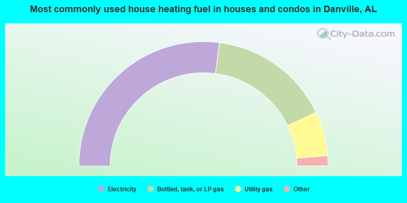
- 54.1%Electricity
- 31.7%Bottled, tank, or LP gas
- 11.6%Utility gas
- 1.8%Wood
- 0.4%Other fuel
- 0.4%No fuel used
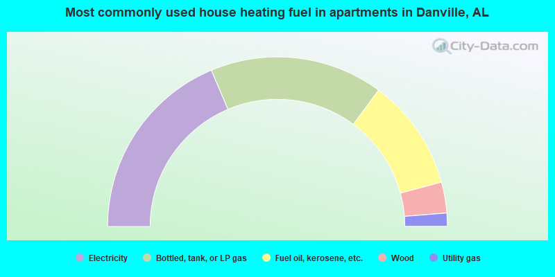
- 37.3%Electricity
- 33.0%Bottled, tank, or LP gas
- 21.3%Fuel oil, kerosene, etc.
- 5.9%Wood
- 2.5%Utility gas
Danville compared to Alabama state average:
- Unemployed percentage below state average.
- Black race population percentage significantly below state average.
- Hispanic race population percentage significantly below state average.
- Median age significantly below state average.
- Foreign-born population percentage significantly below state average.
- Renting percentage below state average.
- Length of stay since moving in significantly above state average.
- Number of rooms per house significantly below state average.
- House age significantly below state average.
- Number of college students below state average.
- Percentage of population with a bachelor's degree or higher below state average.
Danville on our top lists:
- #4 on the list of "Top 101 cities with largest percentage of males in industries: machinery, equipment, and supplies merchant wholesalers (population 5,000+)"
- #5 on the list of "Top 101 cities with largest percentage of females in occupations: pipelayers, plumbers, pipefitters, and steamfitters (population 5,000+)"
- #5 on the list of "Top 101 cities with largest percentage of females in industries: metal and metal products (population 5,000+)"
- #8 on the list of "Top 101 cities with largest percentage of females in industries: fuel dealers (population 5,000+)"
- #8 on the list of "Top 101 cities with largest percentage of males in industries: electrical equipment, appliances, and components (population 5,000+)"
- #10 on the list of "Top 101 cities with largest percentage of females in industries: food and beverage stores (population 5,000+)"
- #11 on the list of "Top 101 cities with largest percentage of females in industries: hardware, plumbing and heating equipment, and supplies merchant wholesalers (population 5,000+)"
- #11 on the list of "Top 101 cities with largest percentage of females in occupations: other healthcare support occupations (population 5,000+)"
- #12 on the list of "Top 101 cities with largest percentage of females in occupations: metal workers and plastic workers (population 5,000+)"
- #13 on the list of "Top 101 cities with largest percentage of females in occupations: plant and system operators (population 5,000+)"
- #16 on the list of "Top 101 cities with largest percentage of females in occupations: entertainers and performers, sports, and related workers (population 5,000+)"
- #18 on the list of "Top 101 cities with largest percentage of males in industries: chemicals (population 5,000+)"
- #19 on the list of "Top 101 cities with largest percentage of males in occupations: other production occupations including supervisors (population 5,000+)"
- #30 on the list of "Top 101 cities with largest percentage of males in industries: truck transportation (population 5,000+)"
- #45 on the list of "Top 101 cities with largest percentage of females in industries: electrical equipment, appliances, and components (population 5,000+)"
- #46 on the list of "Top 101 larger cities with the lowest real estate taxes percentage (population 50,000+)"
- #59 on the list of "Top 101 cities with largest percentage of males in industries: farm supplies merchant wholesalers (population 5,000+)"
- #59 on the list of "Top 101 cities with largest percentage of females in industries: machinery (population 5,000+)"
- #68 on the list of "Top 101 cities with largest percentage of females in industries: used merchandise, gift, novelty, and souvenir, and other miscellaneous stores (population 5,000+)"
- #72 on the list of "Top 101 cities with largest percentage of females in industries: miscellaneous manufacturing (population 5,000+)"
- #74 on the list of "Top 101 counties with highest percentage of residents voting for Romney (Republican) in the 2012 Presidential Election (pop. 50,000+)"

|
|
Total of 13 patent applications in 2008-2024.