Dakota, Wisconsin
Submit your own pictures of this town and show them to the world
- OSM Map
- General Map
- Google Map
- MSN Map
Population change since 2000: -2.5%
 |
| Males: 637 | |
| Females: 590 |
| Median resident age: | 44.1 years |
| Wisconsin median age: | 42.6 years |
Zip codes: 54982.
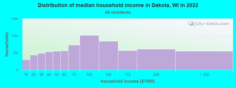
| Dakota: | $56,457 |
| WI: | $70,996 |
Estimated per capita income in 2022: $38,520 (it was $18,401 in 2000)
Dakota town income, earnings, and wages data
Estimated median house or condo value in 2022: $185,704 (it was $84,700 in 2000)
| Dakota: | $185,704 |
| WI: | $252,800 |
Mean prices in 2022: all housing units: $214,925; detached houses: $223,954; townhouses or other attached units: $208,826; in 2-unit structures: $240,363; mobile homes: $67,729
Detailed information about poverty and poor residents in Dakota, WI


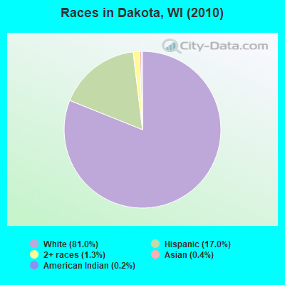
- 99481.0%White alone
- 20917.0%Hispanic
- 161.3%Two or more races
- 50.4%Asian alone
- 20.2%American Indian alone
- 10.08%Native Hawaiian and Other
Pacific Islander alone
Races in Dakota detailed stats: ancestries, foreign born residents, place of birth
 Recent articles from our blog. Our writers, many of them Ph.D. graduates or candidates, create easy-to-read articles on a wide variety of topics.

 | Wisconsin Governor’s Race 2018 (434 replies) |
| Why are people leaving Wisconsin (128 replies) |
| Wisconsin Ranked as 11th Best State to Live (69 replies) |
| Desperate to leave milwaukee (82 replies) |
| If you relocated to Madison from elsewhere.... (33 replies) |
| Walker's proposed cuts to UW System (171 replies) |
Latest news from Dakota, WI collected exclusively by city-data.com from local newspapers, TV, and radio stations
Ancestries: German (52.7%), Polish (10.8%), Irish (10.6%), English (6.8%), Norwegian (4.5%), United States (3.4%).
Current Local Time: CST time zone
Elevation: 843 feet
Land area: 33.2 square miles.
Population density: 37 people per square mile (very low).
49 residents are foreign born (2.1% Latin America, 1.6% Europe).
| This town: | 3.9% |
| Wisconsin: | 3.6% |
| Dakota town: | 1.7% ($1,466) |
| Wisconsin: | 2.0% ($2,245) |
Nearest city with pop. 50,000+: Oshkosh, WI  (37.2 miles , pop. 62,916).
Nearest city with pop. 200,000+: Madison, WI (66.4 miles , pop. 208,054).
Nearest city with pop. 1,000,000+: Chicago, IL (172.3 miles , pop. 2,896,016).
Nearest cities:
), ), ), Latitude: 44.03 N, Longitude: 89.30 W
Area code commonly used in this area: 920

| Here: | 3.2% |
| Wisconsin: | 2.7% |
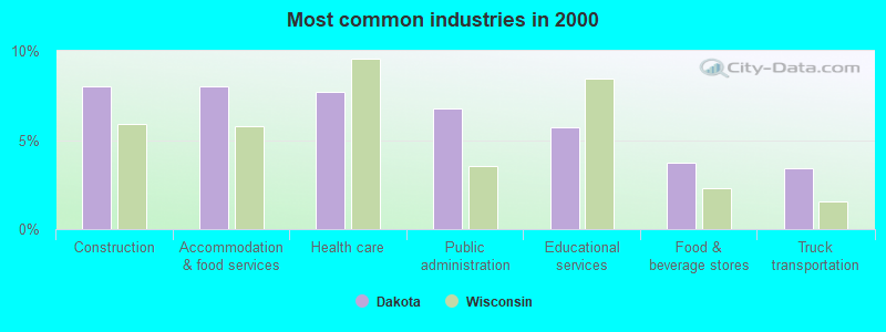
- Construction (8.0%)
- Accommodation & food services (8.0%)
- Health care (7.7%)
- Public administration (6.8%)
- Educational services (5.7%)
- Food & beverage stores (3.8%)
- Truck transportation (3.4%)
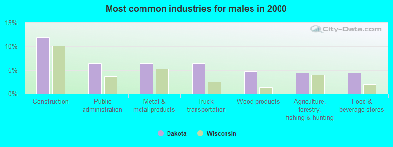
- Construction (11.9%)
- Public administration (6.5%)
- Metal & metal products (6.5%)
- Truck transportation (6.5%)
- Wood products (4.8%)
- Agriculture, forestry, fishing & hunting (4.4%)
- Food & beverage stores (4.4%)
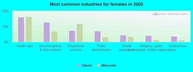
- Health care (16.2%)
- Accommodation & food services (12.8%)
- Educational services (7.5%)
- Public administration (7.1%)
- Social assistance (4.5%)
- Religious, grantmaking, civic, professional, similar organizations (4.1%)
- Construction (3.8%)
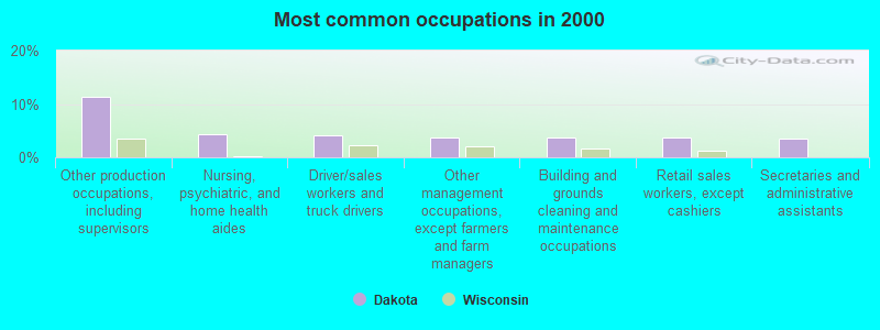
- Other production occupations, including supervisors (11.4%)
- Nursing, psychiatric, and home health aides (4.3%)
- Driver/sales workers and truck drivers (4.1%)
- Other management occupations, except farmers and farm managers (3.8%)
- Building and grounds cleaning and maintenance occupations (3.8%)
- Retail sales workers, except cashiers (3.8%)
- Secretaries and administrative assistants (3.6%)
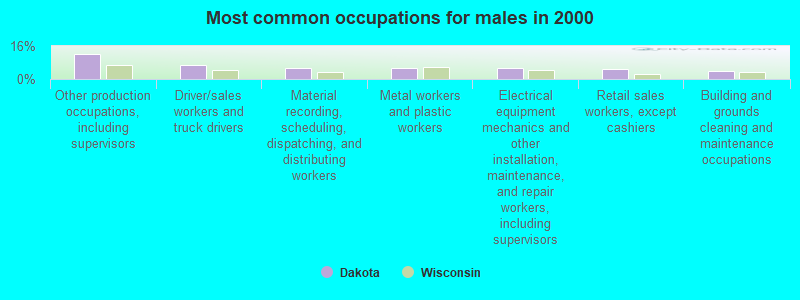
- Other production occupations, including supervisors (12.2%)
- Driver/sales workers and truck drivers (6.8%)
- Material recording, scheduling, dispatching, and distributing workers (5.4%)
- Metal workers and plastic workers (5.4%)
- Electrical equipment mechanics and other installation, maintenance, and repair workers, including supervisors (5.1%)
- Retail sales workers, except cashiers (4.8%)
- Building and grounds cleaning and maintenance occupations (4.1%)

- Other production occupations, including supervisors (10.5%)
- Nursing, psychiatric, and home health aides (9.0%)
- Secretaries and administrative assistants (7.5%)
- Waiters and waitresses (5.6%)
- Other office and administrative support workers, including supervisors (5.6%)
- Other management occupations, except farmers and farm managers (4.9%)
- Other food preparation and serving workers, including supervisors (3.8%)
Average climate in Dakota, Wisconsin
Based on data reported by over 4,000 weather stations


Tornado activity:
Dakota-area historical tornado activity is slightly above Wisconsin state average. It is 55% greater than the overall U.S. average.
On 4/3/1956, a category F4 (max. wind speeds 207-260 mph) tornado 17.8 miles away from the Dakota town center killed 7 people and injured 50 people and caused between $500,000 and $5,000,000 in damages.
On 9/26/1951, a category F4 tornado 20.6 miles away from the town center killed 6 people and injured 3 people and caused between $50,000 and $500,000 in damages.
Earthquake activity:
Dakota-area historical earthquake activity is significantly above Wisconsin state average. It is 7% greater than the overall U.S. average.On 6/28/2004 at 06:10:52, a magnitude 4.2 (4.2 MW, Depth: 6.2 mi, Class: Light, Intensity: IV - V) earthquake occurred 179.0 miles away from Dakota center
On 4/18/2008 at 09:36:59, a magnitude 5.4 (5.1 MB, 4.8 MS, 5.4 MW, 5.2 MW, Class: Moderate, Intensity: VI - VII) earthquake occurred 392.9 miles away from Dakota center
On 6/10/1987 at 23:48:54, a magnitude 5.1 (4.9 MB, 4.4 MS, 4.6 MS, 5.1 LG) earthquake occurred 367.8 miles away from the city center
On 4/18/2008 at 09:36:59, a magnitude 5.2 (5.2 MW, Depth: 8.9 mi) earthquake occurred 392.9 miles away from the city center
On 2/10/2010 at 09:59:35, a magnitude 3.8 (3.8 MW, Depth: 6.2 mi, Class: Light, Intensity: II - III) earthquake occurred 148.3 miles away from Dakota center
On 5/2/2015 at 16:23:07, a magnitude 4.2 (4.2 MW, Depth: 2.8 mi) earthquake occurred 231.5 miles away from Dakota center
Magnitude types: regional Lg-wave magnitude (LG), body-wave magnitude (MB), surface-wave magnitude (MS), moment magnitude (MW)
Natural disasters:
The number of natural disasters in Waushara County (8) is smaller than the US average (15).Major Disasters (Presidential) Declared: 6
Emergencies Declared: 2
Causes of natural disasters: Floods: 5, Storms: 4, Drought: 1, Hurricane: 1, Tornado: 1, Other: 1 (Note: some incidents may be assigned to more than one category).
Hospitals and medical centers near Dakota:
- DAVITA - WAUTOMA DIALYSIS (Dialysis Facility, about 3 miles away; WAUTOMA, WI)
- WAUTOMA CARE CENTER INC (Nursing Home, about 3 miles away; WAUTOMA, WI)
- WAUTOMA CARE CTR (Nursing Home, about 3 miles away; WAUTOMA, WI)
- WILD ROSE MANOR (Nursing Home, about 11 miles away; WILD ROSE, WI)
- WILD ROSE COM MEM HOSPITAL, INC Critical Access Hospitals (about 11 miles away; WILD ROSE, WI)
- WILD ROSE COMMUNITY MEMORIAL HOSPITAL (Hospital, about 11 miles away; WILD ROSE, WI)
- NORTHLAND HOME HLTH (Home Health Center, about 14 miles away; WESTFIELD, WI)
Colleges/universities with over 2000 students nearest to Dakota:
- Mid-State Technical College (about 35 miles; Wisconsin Rapids, WI; Full-time enrollment: 2,128)
- University of Wisconsin-Stevens Point (about 37 miles; Stevens Point, WI; FT enrollment: 9,089)
- University of Wisconsin-Oshkosh (about 38 miles; Oshkosh, WI; FT enrollment: 10,637)
- Fox Valley Technical College (about 46 miles; Appleton, WI; FT enrollment: 5,682)
- Moraine Park Technical College (about 48 miles; Fond du Lac, WI; FT enrollment: 3,079)
- Marian University (about 48 miles; Fond Du Lac, WI; FT enrollment: 2,045)
- Lawrence University (about 48 miles; Appleton, WI; FT enrollment: 2,821)
Points of interest:
Cemeteries: Raymond Cemetery (1), North Dakota Cemetery (2). Display/hide their locations on the map
Lakes and reservoirs: Pickerel Lake (A), Bass Lake (B), Witters Lake (C), Lucky Lake (D), Meilke Lake (E), 2 Reservoir (F), Lower White River Pond 83 (G), Alan Wilcox Flowage 2 (H). Display/hide their locations on the map
Rivers and creeks: Bird Creek (A), West Branch Little Pine Creek (B), West Branch White River (C), East Branch Little Pine Creek (D). Display/hide their locations on the map
Parks in Dakota include: Bass Lake Fen State Natural Area (1), Lunch Creek Wetlands State Natural Area (2). Display/hide their locations on the map
| This town: | 2.5 people |
| Wisconsin: | 2.4 people |
| This town: | 71.0% |
| Whole state: | 64.4% |
| This town: | 3.8% |
| Whole state: | 7.3% |
Likely homosexual households (counted as self-reported same-sex unmarried-partner households)
- Lesbian couples: 0.0% of all households
- Gay men: 0.4% of all households
| This town: | 12.4% |
| Whole state: | 8.7% |
| This town: | 5.1% |
| Whole state: | 3.7% |
For population 15 years and over in Dakota:
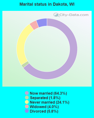
- Never married: 24.1%
- Now married: 64.3%
- Separated: 1.8%
- Widowed: 4.0%
- Divorced: 5.8%
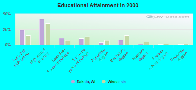
For population 25 years and over in Dakota:
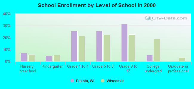
- High school or higher: 76.1%
- Bachelor's degree or higher: 9.8%
- Graduate or professional degree: 2.3%
- Unemployed: 6.4%
- Mean travel time to work (commute): 26.6 minutes
| Here: | 10.4 |
| Wisconsin average: | 11.0 |
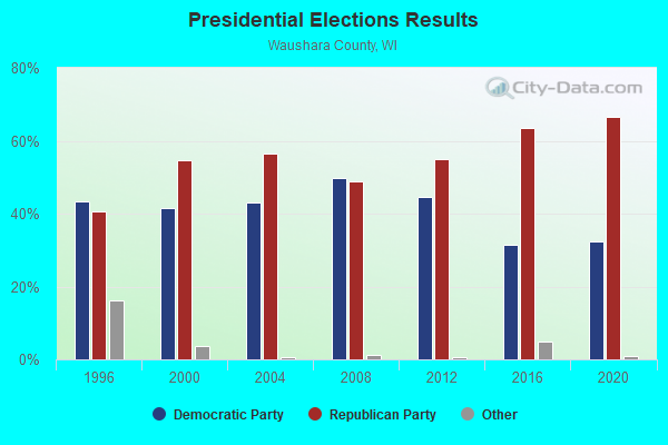
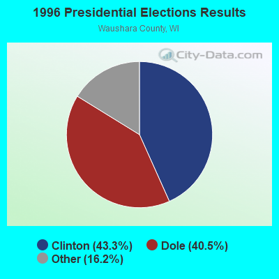
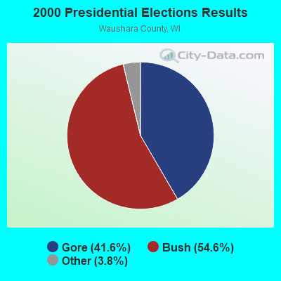

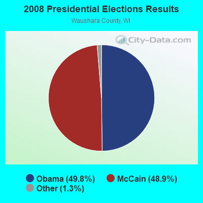
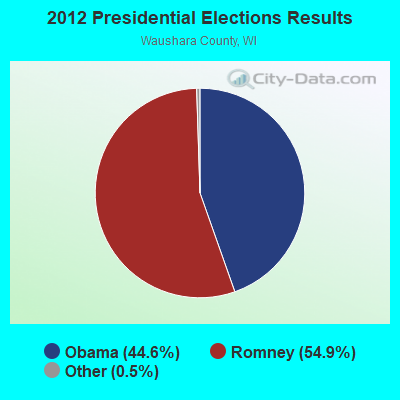

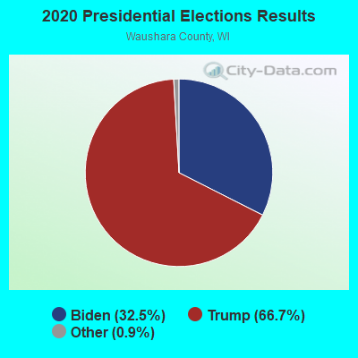
Graphs represent county-level data. Detailed 2008 Election Results
Religion statistics for Dakota, WI (based on Waushara County data)
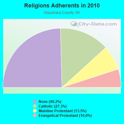
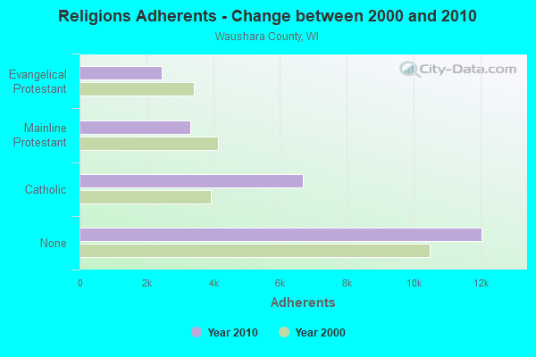
| Religion | Adherents | Congregations |
|---|---|---|
| Catholic | 6,687 | 4 |
| Mainline Protestant | 3,305 | 16 |
| Evangelical Protestant | 2,450 | 20 |
| Other | 3 | 1 |
| None | 12,051 | - |
Food Environment Statistics:
| Waushara County: | 3.64 / 10,000 pop. |
| State: | 1.86 / 10,000 pop. |
| Waushara County: | 4.86 / 10,000 pop. |
| Wisconsin: | 4.12 / 10,000 pop. |
| This county: | 8.50 / 10,000 pop. |
| Wisconsin: | 8.64 / 10,000 pop. |
| Waushara County: | 8.4% |
| Wisconsin: | 7.6% |
| Waushara County: | 28.1% |
| Wisconsin: | 27.5% |
| Waushara County: | 17.9% |
| Wisconsin: | 13.0% |
Strongest AM radio stations in Dakota:
- WSPT (1010 AM; 50 kW; STEVENS POINT, WI)
- WNAM (1280 AM; 50 kW; NEENAH-MENASHA, WI; Owner: CUMULUS LICENSING CORP.)
- WHBY (1150 AM; 25 kW; KIMBERLY, WI; Owner: WOODWARD COMMUNICATIONS, INC.)
- WSAU (550 AM; 20 kW; WAUSAU, WI; Owner: WRIG, INC.)
- WDUX (800 AM; 5 kW; WAUPACA, WI; Owner: LAIRD BROADCASTING COMPANY, INC.)
- WTMJ (620 AM; 50 kW; MILWAUKEE, WI; Owner: JOURNAL BROADCAST CORPORATION)
- WRPN (1600 AM; 5 kW; RIPON, WI)
- WISN (1130 AM; 50 kW; MILWAUKEE, WI; Owner: CAPSTAR TX LIMITED PARTNERSHIP)
- WSCR (670 AM; 50 kW; CHICAGO, IL; Owner: INFINITY BROADCASTING OPERATIONS, INC.)
- WGN (720 AM; 50 kW; CHICAGO, IL; Owner: WGN CONTINENTAL BROADCASTING CO.)
- WFHR (1320 AM; 5 kW; WISCONSIN RAPIDS, WI; Owner: WISCONSIN RAPIDS BROADCASTING, LLC)
- WBBM (780 AM; 50 kW; CHICAGO, IL; Owner: INFINITY BROADCASTING OPERATIONS, INC.)
- WRIG (1390 AM; 10 kW; SCHOFIELD, WI; Owner: WRIG, INC.)
Strongest FM radio stations in Dakota:
- WAUH (102.3 FM; WAUTOMA, WI; Owner: HOMETOWN BROADCASTING LLC)
- WBJZ (104.7 FM; BERLIN, WI; Owner: CAXAMBAS CORPORATION)
- WOLX-FM (94.9 FM; BARABOO, WI; Owner: ENTERCOM MADISON LICENSE, LLC.)
- WGLX-FM (103.3 FM; WISCONSIN RAPIDS, WI; Owner: WISCONSIN RAPIDS BROADCASTING, LLC)
- WPKR (99.5 FM; OMRO, WI; Owner: MIDWEST DIMENSIONS, INC.)
- WIZD (99.9 FM; RUDOLPH, WI; Owner: WRIG, INC)
TV broadcast stations around Dakota:
- W64AU (Channel 64; ADAMS, WI; Owner: STATE OF WISCONSIN - EDUCATIONAL COMMUNICATIONS BOARD)
- WMMF-TV (Channel 68; FOND DU LAC, WI; Owner: PAPPAS TELECASTING OF WISCONSIN, A CALIFORNIA LTD PARTNRSHP)
- W24BV (Channel 24; WHITING, WI; Owner: MS COMMUNICATIONS, LLC)
- National Bridge Inventory (NBI) Statistics
- 8Number of bridges
- 33ft / 9.9mTotal length
- $466,000Total costs
- 8,809Total average daily traffic
- 162Total average daily truck traffic
- 10,267Total future (year 2038) average daily traffic
FCC Registered Antenna Towers:
1- 1 Mi N Of I-90 On Cth 12 (Lat: 43.942500 Lon: -91.434167), Type: 71.0, Overall height: 69 m, Registrant: Riverview Communications Inc, Radiotekpd@aol.Com, , La Cr-escent, Phone: (608) 779-9524
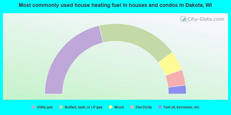
- 42.5%Utility gas
- 37.1%Bottled, tank, or LP gas
- 9.1%Wood
- 7.2%Electricity
- 4.0%Fuel oil, kerosene, etc.
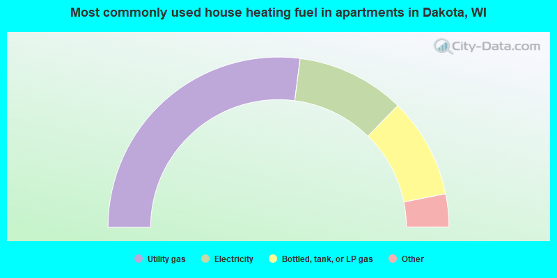
- 54.0%Utility gas
- 20.6%Electricity
- 19.0%Bottled, tank, or LP gas
- 3.2%Fuel oil, kerosene, etc.
- 3.2%Wood
Dakota compared to Wisconsin state average:
- Unemployed percentage below state average.
- Black race population percentage significantly below state average.
- Hispanic race population percentage above state average.
- Renting percentage below state average.
- Length of stay since moving in significantly above state average.
- Number of rooms per house significantly below state average.
- House age significantly below state average.
- Number of college students significantly below state average.
- Percentage of population with a bachelor's degree or higher significantly below state average.