Daisy, Kentucky
Submit your own pictures of this place and show them to the world
- OSM Map
- General Map
- Google Map
- MSN Map

| Males: 865 | |
| Females: 892 |
| Median resident age: | 36.7 years |
| Kentucky median age: | 35.9 years |
Zip code: 41763
| Daisy: | $43,113 |
| KY: | $59,341 |
Estimated per capita income in 2022: $24,344 (it was $10,515 in 2000)
Daisy CCD income, earnings, and wages data
Estimated median house or condo value in 2022: $83,481 (it was $33,500 in 2000)
| Daisy: | $83,481 |
| KY: | $196,300 |
Mean prices in 2022: all housing units: $145,504; detached houses: $183,549; townhouses or other attached units: $204,848; mobile homes: $52,921
Detailed information about poverty and poor residents in Daisy, KY


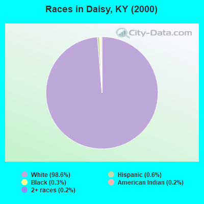
- 1,74198.6%White alone
- 110.6%Hispanic
- 50.3%Black alone
- 40.2%American Indian alone
- 40.2%Two or more races
- 10.06%Asian alone
Races in Daisy detailed stats: ancestries, foreign born residents, place of birth
 Recent articles from our blog. Our writers, many of them Ph.D. graduates or candidates, create easy-to-read articles on a wide variety of topics.
Current Local Time: EST time zone
Land area: 54.5 square miles.
Population density: 32 people per square mile (very low).

| Daisy CCD: | 0.7% ($238) |
| Kentucky: | 0.8% ($610) |
Nearest city with pop. 50,000+: Johnson City, TN  (65.5 miles , pop. 55,469).
Nearest city with pop. 200,000+: Fayette, KY (100.6 miles , pop. 260,512).
Nearest city with pop. 1,000,000+: Chicago, IL (410.0 miles , pop. 2,896,016).
Nearest cities:
), ), ), ), ), ), )Latitude: 37.07 N, Longitude: 83.11 W
Area code commonly used in this area: 606

| Here: | 5.4% |
| Kentucky: | 3.8% |
- Mining, quarrying, oil & gas extraction (21.4%)
- Educational services (10.6%)
- Food & beverage stores (9.9%)
- Health care (6.1%)
- Department & other general merchandise stores (4.9%)
- Sporting goods, camera, hobby & toy stores (4.7%)
- Construction (4.2%)
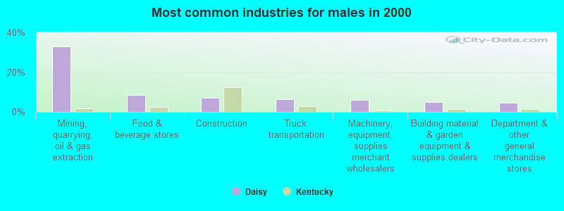
- Mining, quarrying, oil & gas extraction (32.8%)
- Food & beverage stores (8.6%)
- Construction (7.0%)
- Truck transportation (6.2%)
- Machinery, equipment, supplies merchant wholesalers (5.9%)
- Building material & garden equipment & supplies dealers (5.1%)
- Department & other general merchandise stores (4.7%)
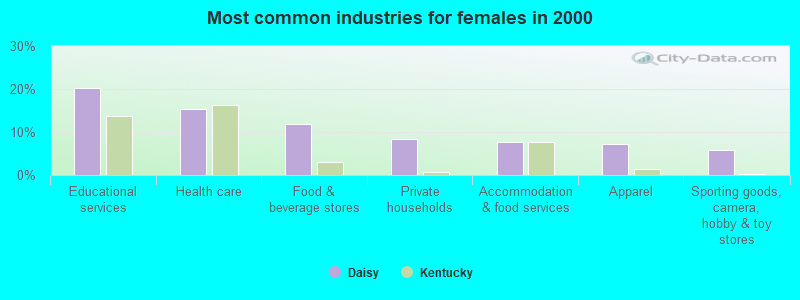
- Educational services (20.1%)
- Health care (15.4%)
- Food & beverage stores (11.8%)
- Private households (8.3%)
- Accommodation & food services (7.7%)
- Apparel (7.1%)
- Sporting goods, camera, hobby & toy stores (5.9%)
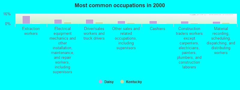
- Extraction workers (12.9%)
- Electrical equipment mechanics and other installation, maintenance, and repair workers, including supervisors (7.1%)
- Driver/sales workers and truck drivers (7.1%)
- Other sales and related occupations, including supervisors (4.9%)
- Cashiers (4.7%)
- Construction traders workers except carpenters, electricians, painters, plumbers, and construction laborers (4.5%)
- Material recording, scheduling, dispatching, and distributing workers (3.8%)
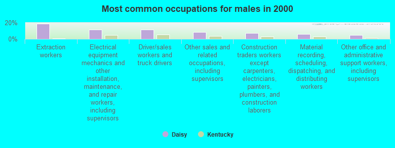
- Extraction workers (18.8%)
- Electrical equipment mechanics and other installation, maintenance, and repair workers, including supervisors (11.7%)
- Driver/sales workers and truck drivers (11.7%)
- Other sales and related occupations, including supervisors (8.2%)
- Construction traders workers except carpenters, electricians, painters, plumbers, and construction laborers (7.4%)
- Material recording, scheduling, dispatching, and distributing workers (6.2%)
- Other office and administrative support workers, including supervisors (4.7%)
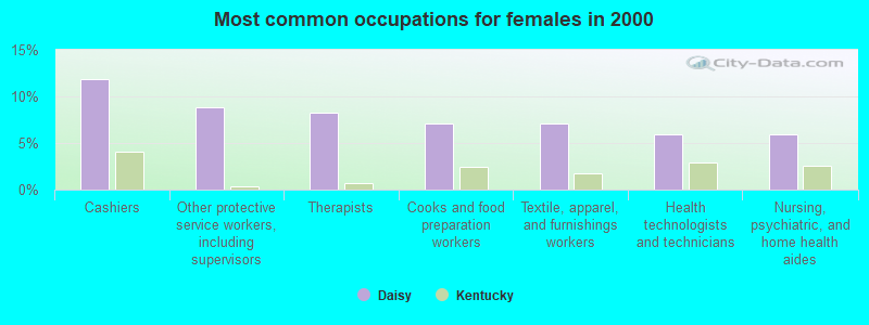
- Cashiers (11.8%)
- Other protective service workers, including supervisors (8.9%)
- Therapists (8.3%)
- Cooks and food preparation workers (7.1%)
- Textile, apparel, and furnishings workers (7.1%)
- Health technologists and technicians (5.9%)
- Nursing, psychiatric, and home health aides (5.9%)
Average climate in Daisy, Kentucky
Based on data reported by over 4,000 weather stations


(lower is better)
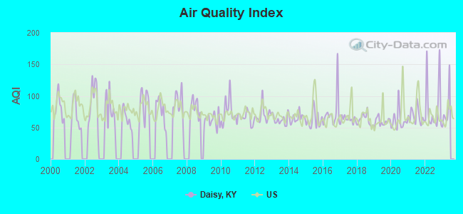
Air Quality Index (AQI) level in 2022 was 81.6. This is about average.
| City: | 81.6 |
| U.S.: | 72.6 |

Ozone [ppb] level in 2022 was 24.9. This is better than average. Closest monitor was 6.5 miles away from the city center.
| City: | 24.9 |
| U.S.: | 33.3 |
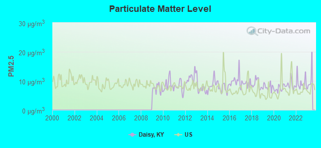
Particulate Matter (PM2.5) [µg/m3] level in 2022 was 9.26. This is about average. Closest monitor was 15.4 miles away from the city center.
| City: | 9.26 |
| U.S.: | 8.11 |
Tornado activity:
Daisy-area historical tornado activity is significantly below Kentucky state average. It is 65% smaller than the overall U.S. average.
On 5/9/1988, a category F3 (max. wind speeds 158-206 mph) tornado 44.3 miles away from the Daisy place center killed one person and injured 15 people and caused between $5,000,000 and $50,000,000 in damages.
On 5/18/1995, a category F2 (max. wind speeds 113-157 mph) tornado 21.0 miles away from the place center caused between $50,000 and $500,000 in damages.
Earthquake activity:
Daisy-area historical earthquake activity is significantly above Kentucky state average. It is 42% greater than the overall U.S. average.On 7/27/1980 at 18:52:21, a magnitude 5.2 (5.1 MB, 4.7 MS, 5.0 UK, 5.2 UK, Class: Moderate, Intensity: VI - VII) earthquake occurred 90.5 miles away from the city center
On 8/9/2020 at 12:07:37, a magnitude 5.1 (5.1 MW, Depth: 4.7 mi) earthquake occurred 119.2 miles away from the city center
On 8/23/2011 at 17:51:04, a magnitude 5.8 (5.8 MW, Depth: 3.7 mi) earthquake occurred 289.8 miles away from the city center
On 11/30/1973 at 07:48:41, a magnitude 4.7 (4.7 MB, 4.6 ML, Class: Light, Intensity: IV - V) earthquake occurred 100.1 miles away from the city center
On 9/7/1988 at 02:28:09, a magnitude 4.6 (4.5 MB, 4.6 LG) earthquake occurred 85.0 miles away from Daisy center
On 11/10/2012 at 17:08:14, a magnitude 4.2 (4.2 MW, Depth: 10.6 mi) earthquake occurred 5.5 miles away from Daisy center
Magnitude types: regional Lg-wave magnitude (LG), body-wave magnitude (MB), local magnitude (ML), surface-wave magnitude (MS), moment magnitude (MW)
Natural disasters:
The number of natural disasters in Perry County (34) is a lot greater than the US average (15).Major Disasters (Presidential) Declared: 28
Emergencies Declared: 3
Causes of natural disasters: Floods: 25, Storms: 25, Tornadoes: 12, Mudslides: 10, Landslides: 6, Winter Storms: 5, Winds: 3, Snowstorms: 2, Blizzard: 1, Freeze: 1, Hurricane: 1, Snow: 1, Snowfall: 1, Other: 1 (Note: some incidents may be assigned to more than one category).
Hospitals and medical centers near Daisy:
- MOUNTAIN COMMUNITY HOSPICE (Hospital, about 15 miles away; HAZARD, KY)
- HAZARD HEALTH AND REHABILITATION CENTER (Nursing Home, about 16 miles away; HAZARD, KY)
- MARY BRECKINRIDGE HOME HEALTH AGENCY (Home Health Center, about 16 miles away; HYDEN, KY)
- MARY BRECKINRIDGE ARH HOSPITAL Critical Access Hospitals (about 16 miles away; HYDEN, KY)
Colleges/universities with over 2000 students nearest to Daisy:
- Southeast Kentucky Community and Technical College (about 10 miles; Cumberland, KY; Full-time enrollment: 2,196)
- Hazard Community and Technical College (about 12 miles; Hazard, KY; FT enrollment: 2,087)
- Lincoln Memorial University (about 46 miles; Harrogate, TN; FT enrollment: 3,706)
- Big Sandy Community and Technical College (about 47 miles; Prestonsburg, KY; FT enrollment: 2,660)
- Northeast State Community College (about 57 miles; Blountville, TN; FT enrollment: 4,480)
- Walters State Community College (about 61 miles; Morristown, TN; FT enrollment: 4,359)
- University of the Cumberlands (about 63 miles; Williamsburg, KY; FT enrollment: 3,585)
Points of interest:
Notable locations in Daisy: Cornettsville Fire Department (A), Open Door Childrens Home (B), Leatherwood Fire Department (C). Display/hide their locations on the map
Churches in Daisy include: Bethanna Church (A), Macedonia Community Church (B), Holcom Church (C), Berean Baptist Church (D), Big Leatherwood Church (E), Berean Church (F), Stony Fork Church (G), Mount Olivet Baptist Church (H), Mount Olivet Church (I). Display/hide their locations on the map
Cemetery: Turner Cemetery (1). Display/hide its location on the map
Streams, rivers, and creeks: Bear Branch (A), Clover Fork (B), Deephole Branch (C), Dike Branch (D), Hicks Branch (E), Horn Branch (F), Beech Rock Branch (G), Jim Polly Branch (H), Leatherwood Creek (I). Display/hide their locations on the map
| This place: | 2.4 people |
| Kentucky: | 2.5 people |
| This place: | 70.0% |
| Whole state: | 66.9% |
| This place: | 5.0% |
| Whole state: | 6.4% |
Likely homosexual households (counted as self-reported same-sex unmarried-partner households)
- Lesbian couples: 0.3% of all households
- Gay men: 0.3% of all households
| This place: | 31.3% |
| Whole state: | 15.8% |
| This place: | 21.6% |
| Whole state: | 6.6% |
For population 15 years and over in Daisy:
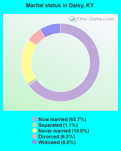
- Never married: 19.0%
- Now married: 65.7%
- Separated: 1.1%
- Widowed: 8.8%
- Divorced: 6.5%
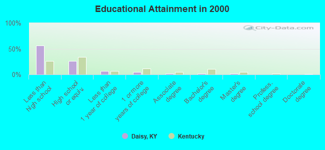
For population 25 years and over in Daisy:
- High school or higher: 43.5%
- Bachelor's degree or higher: 4.2%
- Graduate or professional degree: 2.3%
- Unemployed: 12.0%
- Mean travel time to work (commute): 28.6 minutes
| Here: | 20.5 |
| Kentucky average: | 13.8 |
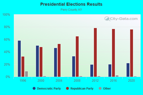
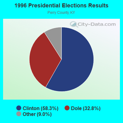
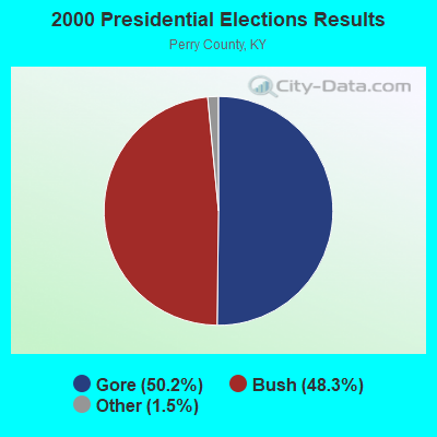
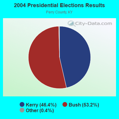
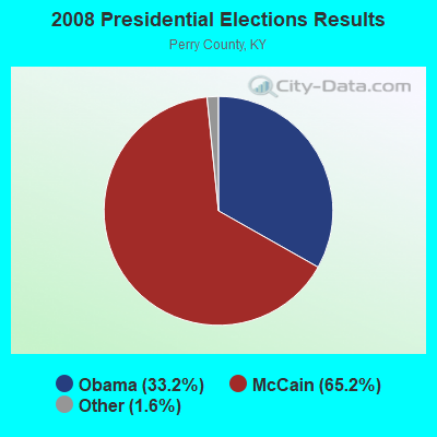
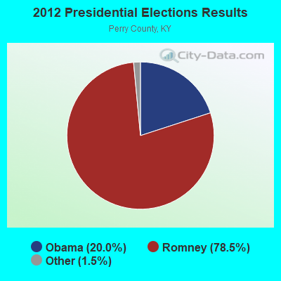
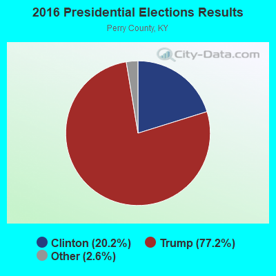
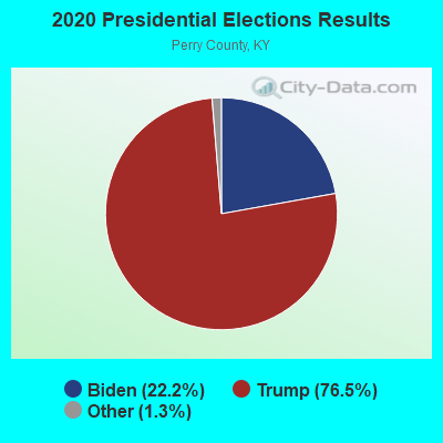
Graphs represent county-level data. Detailed 2008 Election Results
Religion statistics for Daisy, KY (based on Perry County data)
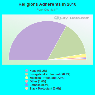
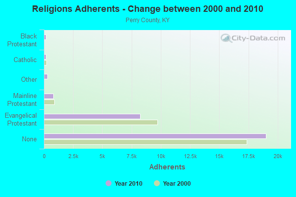
| Religion | Adherents | Congregations |
|---|---|---|
| Evangelical Protestant | 8,245 | 61 |
| Mainline Protestant | 791 | 10 |
| Other | 301 | 1 |
| Catholic | 188 | 1 |
| Black Protestant | 180 | 1 |
| None | 19,007 | - |
Food Environment Statistics:
| Perry County: | 3.09 / 10,000 pop. |
| Kentucky: | 2.19 / 10,000 pop. |
| This county: | 1.03 / 10,000 pop. |
| Kentucky: | 0.74 / 10,000 pop. |
| This county: | 6.86 / 10,000 pop. |
| Kentucky: | 4.36 / 10,000 pop. |
| Perry County: | 5.14 / 10,000 pop. |
| Kentucky: | 5.74 / 10,000 pop. |
| Here: | 10.9% |
| State: | 11.0% |
| Perry County: | 34.7% |
| State: | 30.0% |
| Here: | 23.0% |
| Kentucky: | 15.9% |
Strongest AM radio stations in Daisy:
- WKIC (1390 AM; 5 kW; HAZARD, KY)
- WFSR (970 AM; 5 kW; HARLAN, KY; Owner: EASTERN BROADCASTING COMPAY)
- WTCW (920 AM; 4 kW; WHITESBURG, KY; Owner: T.C.W. BROADCASTING , INC.)
- WCPM (1280 AM; 1 kW; CUMBERLAND, KY; Owner: CUMBERLAND CITY BROADCASTING, INC.)
- WKVL (850 AM; daytime; 50 kW; KNOXVILLE, TN; Owner: HORNE RADIO, LLC)
- WHLN (1410 AM; 5 kW; HARLAN, KY)
- WEZC (1480 AM; daytime; 5 kW; NEON, KY; Owner: JESUS COMMUNICATION ILNC.)
- WGOC (640 AM; 10 kW; BLOUNTVILLE, TN; Owner: CITADEL BROADCASTING COMPANY)
- WNVA (1350 AM; 5 kW; NORTON, VA; Owner: RADIO-WISE, INC.)
- WEKG (810 AM; daytime; 5 kW; JACKSON, KY; Owner: INTERMOUNTAIN B/CING CO., INC.)
- WFGW (1010 AM; 50 kW; BLACK MOUNTAIN, NC; Owner: BLUE RIDGE BROADCASTING CORP.)
- WMTC (730 AM; 5 kW; VANCLEVE, KY; Owner: THE KENTUCKY MOUNTAIN HOLINESS ASSN.)
- WLSI (900 AM; 5 kW; PIKEVILLE, KY; Owner: EAST KENTUCKY BROADCASTING CORPORATION)
Strongest FM radio stations in Daisy:
- WSEH (102.7 FM; CUMBERLAND, KY; Owner: CUMBERLAND CITY BROADCASTING, INC.)
- WSGS (101.1 FM; HAZARD, KY; Owner: MOUNTAIN BROADCASTING SERVICE, INC.)
- WEKH (90.9 FM; HAZARD, KY; Owner: EASTERN KENTUCKY UNIVERSITY)
- WAXM (93.5 FM; BIG STONE GAP, VA; Owner: VALLEY BROADCASTING, INC.)
- WZQQ (97.9 FM; HYDEN, KY; Owner: LESLIE COUNTY BROADCASTING, INC.)
- WJMD (104.7 FM; HAZARD, KY; Owner: HAZARD BROADCASTING SERVICES)
- WIFX-FM (94.3 FM; JENKINS, KY; Owner: LETCHER COUNTY BROADCASTING, INC)
- WXKQ-FM (103.9 FM; WHITESBURG, KY; Owner: T.C.W. BROADCASTING , INC.)
- WTUK (105.1 FM; HARLAN, KY; Owner: EASTERN BROADCASTING COMPANY)
- WMMT (88.7 FM; WHITESBURG, KY; Owner: APPALSHOP, INCORPORATED)
- W223AA (92.5 FM; BIG STONE GAP, VA; Owner: VALLEY BROADCASTING, INC.)
- WDXC (102.3 FM; POUND, VA; Owner: WDXC RADIO, INC.)
- WTFM (98.5 FM; KINGSPORT, TN; Owner: HOLSTON VALLEY BROADCASTING CORP.)
- WKCB-FM (107.1 FM; HINDMAN, KY; Owner: HINDMAN BROADCASTING CORPORATION)
- WPKE-FM (103.1 FM; COAL RUN, KY; Owner: EAST KENTUCKY BROADCASTING CORP.)
- WWJD (91.7 FM; PIPPA PASSES, KY; Owner: ALICE LLOYD COLLEGE)
- WJDT (106.5 FM; ROGERSVILLE, TN; Owner: C & S BROADCASTING)
- WMIK-FM (92.7 FM; MIDDLESBORO, KY; Owner: GATEWAY BROADCASTING, INC.)
- WRZK (95.9 FM; COLONIAL HEIGHTS, TN; Owner: MURRAY COMMUNICATIONS)
- WBGQ (100.7 FM; BULLS GAP, TN; Owner: CHEROKEE BROADCASTING)
TV broadcast stations around Daisy:
- W24BT (Channel 24; TALBERT, KY; Owner: MS COMMUNICATIONS, LLC)
- WYMT-TV (Channel 57; HAZARD, KY; Owner: WYMT LICENSEE CORP.)
- W31BU (Channel 31; TALBERT, KY; Owner: MS COMMUNICATIONS, LLC)
- W53BQ (Channel 53; TALBERT, KY; Owner: MS COMMUNICATIONS, LLC)
- W69ED (Channel 69; TALBERT, KY; Owner: MS COMMUNICATIONS, LLC)
- WKHA (Channel 35; HAZARD, KY; Owner: KENTUCKY AUTHORITY FOR EDUCATIONAL TV)
- W26BK (Channel 26; TALBERT, KY; Owner: MS COMMUNICATIONS, LLC)
- W20BO (Channel 20; TALBERT, KY; Owner: MS COMMUNICATIONS, LLC)
- W16BI (Channel 16; TALBERT, KY; Owner: MS COMMUNICATIONS, LLC)
- WAGV (Channel 44; HARLAN, KY; Owner: LIVING FAITH MINISTRIES, INC.)
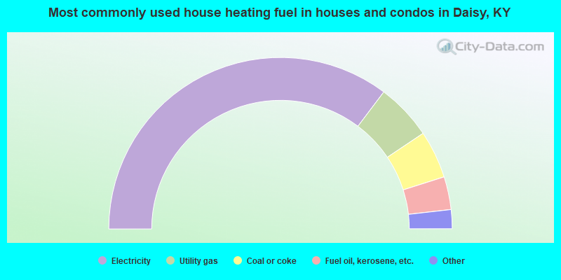
- 70.5%Electricity
- 10.6%Utility gas
- 9.0%Coal or coke
- 6.2%Fuel oil, kerosene, etc.
- 1.9%Wood
- 1.7%Bottled, tank, or LP gas
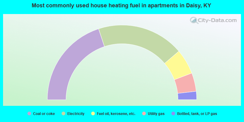
- 39.9%Coal or coke
- 37.7%Electricity
- 10.9%Fuel oil, kerosene, etc.
- 8.0%Utility gas
- 3.6%Bottled, tank, or LP gas
Daisy compared to Kentucky state average:
- Median house value significantly below state average.
- Black race population percentage significantly below state average.
- Hispanic race population percentage significantly below state average.
- Median age below state average.
- Foreign-born population percentage significantly below state average.
- Renting percentage below state average.
- Length of stay since moving in significantly above state average.
- Number of rooms per house significantly below state average.
- House age significantly below state average.
- Percentage of population with a bachelor's degree or higher significantly below state average.