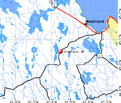
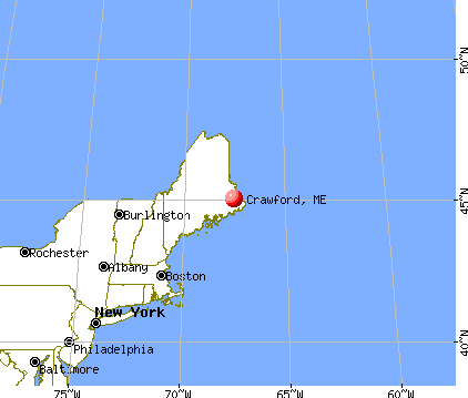
Crawford, Maine
Submit your own pictures of this town and show them to the world
- OSM Map
- General Map
- Google Map
- MSN Map
Population change since 2000: -2.8%
 |
| Males: 47 | |
| Females: 58 |
| Median resident age: | 50.5 years |
| Maine median age: | 43.0 years |
Zip code: 04694
| Crawford: | $87,766 |
| ME: | $69,543 |
Estimated per capita income in 2022: $31,293 (it was $13,864 in 2000)
Estimated median house or condo value in 2022: $230,658 (it was $95,000 in 2000)
| Crawford: | $230,658 |
| ME: | $290,600 |
Mean prices in 2022: all housing units: $208,896; detached houses: $229,377; townhouses or other attached units: $190,242; in 2-unit structures: $139,050; in 3-to-4-unit structures: $456,045; in 5-or-more-unit structures: $413,457; mobile homes: $94,515; occupied boats, rvs, vans, etc.: $45,679
Detailed information about poverty and poor residents in Crawford, ME


- 10398.1%White alone
- 21.9%Hispanic

 Recent articles from our blog. Our writers, many of them Ph.D. graduates or candidates, create easy-to-read articles on a wide variety of topics.

 | Maine weather thread (3207 replies) |
| Moving to Crawford, Maine (9 replies) |
| Foodie Towns? (36 replies) |
| Bento's Closed (22 replies) |
| Update on push to make Baxter National Park land?? (40 replies) |
| We're in Maine... "What have you hit with your vehicle in your life time?" (44 replies) |
Latest news from Crawford, ME collected exclusively by city-data.com from local newspapers, TV, and radio stations
Ancestries: English (38.0%), Irish (25.0%), United States (16.7%), Scottish (3.7%), French (2.8%), Swedish (1.9%).
Current Local Time: EST time zone
Incorporated on 02/11/1828
Elevation: 287 feet
Land area: 34.6 square miles.
Population density: 3.0 people per square mile (very low).
5 residents are foreign born (4.6% North America).
| This town: | 4.6% |
| Maine: | 2.9% |
| Crawford town: | 1.1% ($1,025) |
| Maine: | 1.5% ($1,417) |
Nearest city with pop. 50,000+: Portland, ME  (162.5 miles , pop. 64,249).
Nearest city with pop. 200,000+: Boston, MA (255.8 miles , pop. 589,141).
Nearest city with pop. 1,000,000+: Bronx, NY (429.4 miles , pop. 1,332,650).
Nearest cities:
), ), Latitude: 45.01 N, Longitude: 67.57 W
Area code commonly used in this area: 207


Single-family new house construction building permits:
- 2022: 1 building, cost: $135,000
- 2020: 4 buildings, average cost: $193,600
- 2014: 1 building, cost: $120,000
- 2009: 1 building, cost: $105,000
- 2008: 2 buildings, average cost: $75,000
- 2007: 3 buildings, average cost: $60,000
- 2006: 2 buildings, average cost: $15,000
- 2005: 1 building, cost: $95,000
- 2004: 3 buildings, average cost: $56,700
- 2003: 1 building, cost: $132,800
- 2002: 2 buildings, average cost: $130,700
- 2001: 1 building, cost: $22,000
- 1999: 2 buildings, average cost: $35,000
- 1997: 1 building, cost: $25,000


| Here: | 3.0% |
| Maine: | 3.4% |

Average climate in Crawford, Maine
Based on data reported by over 4,000 weather stations


Earthquake activity:
Crawford-area historical earthquake activity is significantly above Maine state average. It is 84% smaller than the overall U.S. average.On 10/16/2012 at 23:12:25, a magnitude 4.7 (4.7 ML, Depth: 10.0 mi, Class: Light, Intensity: IV - V) earthquake occurred 181.1 miles away from the city center
On 4/20/2002 at 10:50:47, a magnitude 5.3 (5.3 ML, Depth: 3.0 mi, Class: Moderate, Intensity: VI - VII) earthquake occurred 302.7 miles away from the city center
On 4/20/2002 at 10:50:47, a magnitude 5.2 (5.2 MB, 4.2 MS, 5.2 MW, 5.0 MW) earthquake occurred 304.0 miles away from Crawford center
On 1/19/1982 at 00:14:42, a magnitude 4.7 (4.5 MB, 4.7 MD, 4.5 LG) earthquake occurred 225.1 miles away from Crawford center
On 10/7/1983 at 10:18:46, a magnitude 5.3 (5.1 MB, 5.3 LG, 5.1 ML) earthquake occurred 341.8 miles away from Crawford center
On 10/3/2006 at 00:07:38, a magnitude 3.7 (3.7 MD, Depth: 6.2 mi, Class: Light, Intensity: II - III) earthquake occurred 52.5 miles away from Crawford center
Magnitude types: regional Lg-wave magnitude (LG), body-wave magnitude (MB), duration magnitude (MD), local magnitude (ML), surface-wave magnitude (MS), moment magnitude (MW)
Natural disasters:
The number of natural disasters in Washington County (20) is greater than the US average (15).Major Disasters (Presidential) Declared: 14
Emergencies Declared: 6
Causes of natural disasters: Floods: 11, Storms: 10, Snows: 5, Winds: 2, Winter Storms: 2, Blizzard: 1, Heavy Rain: 1, Hurricane: 1, Ice Storm: 1, Landslide: 1, Snowfall: 1, Other: 2 (Note: some incidents may be assigned to more than one category).

Colleges/universities with over 2000 students nearest to Crawford:
- University of Maine (about 55 miles; Orono, ME; Full-time enrollment: 8,931)
- Husson University (about 61 miles; Bangor, ME; FT enrollment: 2,421)
- University of Maine at Augusta (about 119 miles; Augusta, ME; FT enrollment: 3,204)
- University of Maine at Farmington (about 129 miles; Farmington, ME; FT enrollment: 2,036)
- Southern Maine Community College (about 162 miles; South Portland, ME; FT enrollment: 4,666)
- University of Southern Maine (about 163 miles; Portland, ME; FT enrollment: 6,647)
- Saint Joseph's College of Maine (about 166 miles; Standish, ME; FT enrollment: 2,010)
Points of interest:
Cemetery: Old Crawford Cemetery (1). Display/hide its location on the map
Lakes and reservoirs: Beaver Pond (A), Crawford Lake (B). Display/hide their locations on the map
Streams, rivers, and creeks: Seavey Brook (A), Little Huntley Brook (B), Harmon Brook (C), Dead Brook (D), Barrows Stream (E). Display/hide their locations on the map
| This town: | 2.2 people |
| Maine: | 2.3 people |
| This town: | 66.7% |
| Whole state: | 62.9% |
| This town: | 8.3% |
| Whole state: | 9.4% |
Likely homosexual households (counted as self-reported same-sex unmarried-partner households)
- Lesbian couples: 4.2% of all households
- Gay men: 0.0% of all households
| This town: | 24.0% |
| Whole state: | 10.9% |
| This town: | 13.0% |
| Whole state: | 4.1% |
For population 15 years and over in Crawford:

- Never married: 4.2%
- Now married: 54.9%
- Separated: 0.0%
- Widowed: 19.7%
- Divorced: 21.1%
For population 25 years and over in Crawford:
- High school or higher: 70.8%
- Bachelor's degree or higher: 18.5%
- Graduate or professional degree: 7.7%
- Unemployed: 9.7%
- Mean travel time to work (commute): 30.5 minutes


| Here: | 14.0 |
| Maine average: | 11.2 |
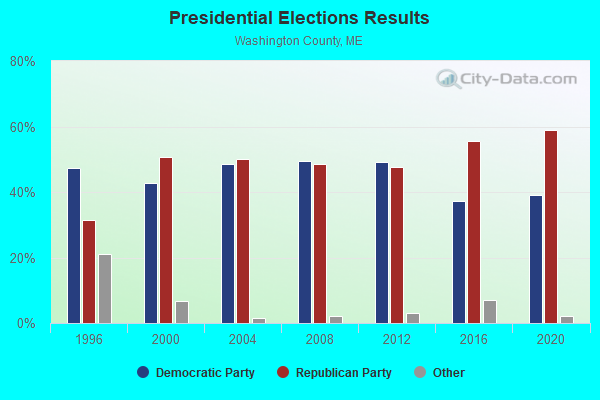

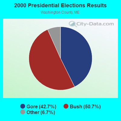


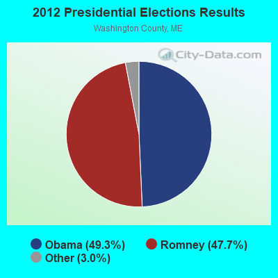
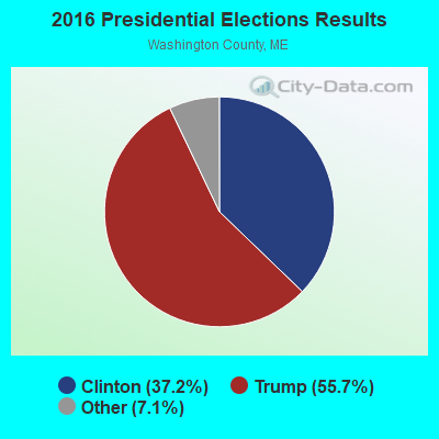
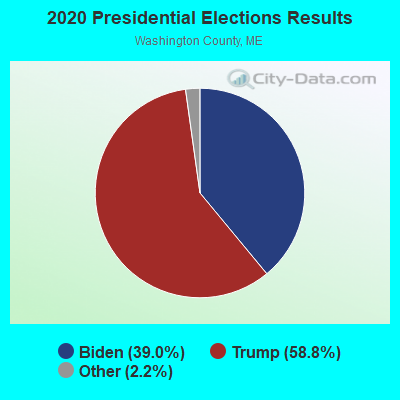
Graphs represent county-level data. Detailed 2008 Election Results
Religion statistics for Crawford, ME (based on Washington County data)
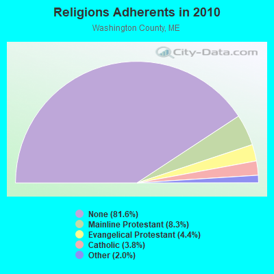
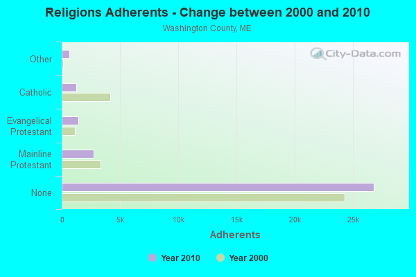
| Religion | Adherents | Congregations |
|---|---|---|
| Mainline Protestant | 2,731 | 37 |
| Evangelical Protestant | 1,442 | 31 |
| Catholic | 1,238 | 10 |
| Other | 648 | 13 |
| None | 26,797 | - |
Food Environment Statistics:
| This county: | 4.89 / 10,000 pop. |
| Maine: | 2.80 / 10,000 pop. |
| This county: | 1.22 / 10,000 pop. |
| State: | 2.20 / 10,000 pop. |
| This county: | 9.78 / 10,000 pop. |
| Maine: | 5.75 / 10,000 pop. |
| This county: | 11.31 / 10,000 pop. |
| State: | 11.02 / 10,000 pop. |
| Here: | 9.4% |
| Maine: | 8.2% |
| Here: | 28.3% |
| State: | 25.0% |
Strongest AM radio stations in Crawford:
- WZON (620 AM; 5 kW; BANGOR, ME; Owner: THE ZONE CORPORATION)
- WABI (910 AM; 5 kW; BANGOR, ME; Owner: CLEAR CHANNEL BROADCASTING LICENSES, INC.)
- WDEA (1370 AM; 5 kW; ELLSWORTH, ME; Owner: CUMULUS LICENSING CORP.)
- WRKO (680 AM; 50 kW; BOSTON, MA; Owner: ENTERCOM BOSTON LICENSE, LLC)
- WEEI (850 AM; 50 kW; BOSTON, MA; Owner: ENTERCOM BOSTON LICENSE, LLC)
- WSKW (1160 AM; 10 kW; SKOWHEGAN, ME; Owner: MOUNTAIN WIRELESS, INCORPORATED)
- WREM (710 AM; daytime; 5 kW; MONTICELLO, ME; Owner: ALLAN H WEINER)
- WBZ (1030 AM; 50 kW; BOSTON, MA; Owner: INFINITY BROADCASTING OPERATIONS, INC.)
- WNNZ (640 AM; 50 kW; WESTFIELD, MA; Owner: CLEAR CHANNEL BROADCASTING LICENSES, INC.)
- WCRN (830 AM; 50 kW; WORCESTER, MA; Owner: CARTER BROADCASTING CORPORATION)
- WALE (990 AM; 50 kW; GREENVILLE, RI; Owner: NORTH AMERICAN BROADCASTING CO., INC.)
- WKOX (1200 AM; 50 kW; FRAMINGHAM, MA; Owner: CAPSTAR TX LIMITED PARTNERSHIP)
- WTME (780 AM; 10 kW; RUMFORD, ME; Owner: MOUNTAIN VALLEY BROADCASTING, INC.)
Strongest FM radio stations in Crawford:
- WMED (89.7 FM; CALAIS, ME; Owner: MAINE PUBLIC BROADCASTING CORPORATION)
- WCRQ (102.9 FM; DENNYSVILLE, ME; Owner: WQDY, INC.)
- WHCF (88.5 FM; BANGOR, ME; Owner: BANGOR BAPTIST CHURCH)
- WVOM (103.9 FM; HOWLAND, ME; Owner: CLEAR CHANNEL BROADCASTING LICENSES, INC.)
- WNSX (97.7 FM; WINTER HARBOR, ME; Owner: CLEAR CHANNEL BROADCASTING LICENSES, INC.)
- WQDY-FM (92.7 FM; CALAIS, ME; Owner: WQDY, INC.)
- WALZ-FM (95.3 FM; MACHIAS, ME; Owner: WILLIAM MCVICAR & ROGER HOLST, GEN. PARTNERSHIP)
TV broadcast stations around Crawford:
- W21BH (Channel 21; MACHIAS, ME; Owner: TRINITY BROADCASTING NETWORK)
- WMED-TV (Channel 13; CALAIS, ME; Owner: MAINE PUBLIC BROADCASTING CORP.)
- W57AQ (Channel 57; CALAIS, ME; Owner: PACIFIC AND SOUTHERN COMPANY, INC.)
Crawford fatal accident list:
Nov 16, 2020 05:56 AM, Sr-9, Lat: 44.998378, Lon: -67.566631, Vehicles: 2, Persons: 2, Fatalities: 1
Jul 27, 2015 01:50 PM, Sr-9 Airline Road, Lat: 45.000069, Lon: -67.601439, Vehicles: 2, Persons: 3, Fatalities: 1
Jun 25, 2012 06:56 AM, Sr-3, Lat: 45.097922, Lon: -67.461525, Vehicles: 1, Persons: 1, Fatalities: 1
Dec 23, 2007 06:03 PM, Sr-9, Lat: 45.055853, Lon: -67.550164, Vehicles: 1, Persons: 4, Fatalities: 1
Nov 4, 1998 02:55 PM, Sr-9, Vehicles: 1, Persons: 1, Fatalities: 1
- National Bridge Inventory (NBI) Statistics
- 3Number of bridges
- 10ft / 3.0mTotal length
- 5,660Total average daily traffic
- 281Total average daily truck traffic
- 7,931Total future (year 2036) average daily traffic
FCC Registered Amateur Radio Licenses:
2- Call Sign: WA1WZK, Licensee ID: L01150166, Grant Date: 11/20/2018, Expiration Date: 02/10/2029, Certifier: Courtney E Henry, Registrant: Courtney E Henry, Eastern Shore Drive, Crawford, ME 04694
- Call Sign: KC1PWP, Licensee ID: L02487704, Grant Date: 09/27/2021, Expiration Date: 09/27/2031, Certifier: Leonard D Hanson Ii, Registrant: Leonard D Hanson Ii, 2615 Airline Rd, Crawford, ME 04694
Crawford compared to Maine state average:
- Black race population percentage significantly below state average.
- Median age above state average.
- Renting percentage significantly below state average.
- Length of stay since moving in significantly above state average.
- Number of rooms per house significantly below state average.
- House age significantly below state average.
- Number of college students significantly below state average.