Coy-Fatama, Alabama
Submit your own pictures of this place and show them to the world
- OSM Map
- Google Map
- MSN Map
| Males: 442 | |
| Females: 536 |
| Median resident age: | 35.1 years |
| Alabama median age: | 35.8 years |
Zip code: 36435
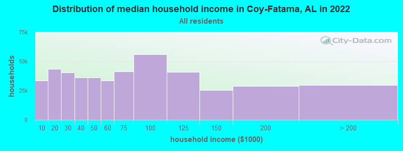
| Coy-Fatama: | $34,798 |
| AL: | $59,674 |
Estimated per capita income in 2022: $16,850 (it was $8,872 in 2000)
Coy-Fatama CCD income, earnings, and wages data
Estimated median house or condo value in 2022: $70,763 (it was $30,000 in 2000)
| Coy-Fatama: | $70,763 |
| AL: | $200,900 |
Mean prices in 2022: all housing units: $110,504; detached houses: $155,599; mobile homes: $41,921
Detailed information about poverty and poor residents in Coy-Fatama, AL
Compare current foreclosures near your location:
| Photo | Address | Area | Beds / Baths | Price | Details |
|---|---|---|---|---|---|

|
#1
N Rhodes St
Pretty Prairie, KS 67570
|
1,725 sq. feet
|
2 baths 4 beds |
show details | |

|
#2
W 21st St N
Cheney, KS 67025
|
3,190 sq. feet
|
3 baths 5 beds |
show details | |

|
#3
NE Waterloo Ave
Murdock, KS 67111
|
1,220 sq. feet
|
1 baths 3 beds |
show details | |

|
#4
E Arlington Rd
Haven, KS 67543
|
960 sq. feet
|
1 baths 2 beds |
show details | |

|
#5
E Winterset St
Goddard, KS 67052
|
816 sq. feet
|
1 baths 2 beds |
show details | |

|
#6
W 39th St S
Goddard, KS 67052
|
4,221 sq. feet
|
3 baths 3 beds |
show details | |

|
#7
E 4th Ave Apt 1
Cheney, KS 67025
|
- sq. feet
|
- baths - beds |
show details | |

|
#8
SE Viney Ave
Murdock, KS 67111
|
- sq. feet
|
- baths - beds |
show details | |

|
#9
W Main St
Mount Hope, KS 67108
|
- sq. feet
|
- baths - beds |
show details | |

|
#10
N 189th Cir W
Colwich, KS 67030
|
- sq. feet
|
- baths - beds |
show details |
| Photo | Address | Area | Beds / Baths | Price | Details |
|---|---|---|---|---|---|

|
#11
N Main St
Goddard, KS 67052
|
- sq. feet
|
- baths - beds |
show details | |

|
#12
Martens Ct
Goddard, KS 67052
|
- sq. feet
|
- baths - beds |
show details | |

|
#13
W Maple St Lot D
Goddard, KS 67052
|
- sq. feet
|
- baths - beds |
show details | |

|
#14
S 339th St W
Cheney, KS 67025
|
- sq. feet
|
- baths - beds |
show details | |

|
#15
E Casey Dr
Goddard, KS 67052
|
- sq. feet
|
- baths - beds |
show details | |

|
Check over 1 million property listings on Foreclosure.com!
|
browse all offers | |||

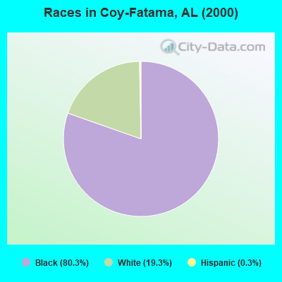
- 81180.3%Black alone
- 19519.3%White alone
- 30.3%Hispanic
- 10.10%Two or more races
 Recent articles from our blog. Our writers, many of them Ph.D. graduates or candidates, create easy-to-read articles on a wide variety of topics.
Current Local Time: CST time zone
Land area: 163.3 square miles.
Population density: 6.0 people per square mile (very low).
| Coy-Fatama CCD: | 0.7% ($199) |
| Alabama: | 0.4% ($289) |
Nearest city with pop. 50,000+: Montgomery, AL  (72.0 miles , pop. 201,568).
Nearest city with pop. 1,000,000+: Houston, TX (498.0 miles , pop. 1,953,631).
Nearest cities:
), ), ), )Latitude: 31.88 N, Longitude: 87.37 W
Area code commonly used in this area: 334
| Here: | 9.3% |
| Alabama: | 2.6% |
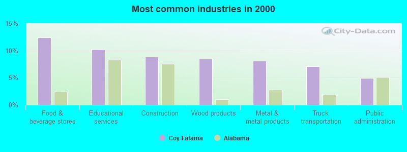
- Food & beverage stores (12.4%)
- Educational services (10.2%)
- Construction (8.8%)
- Wood products (8.5%)
- Metal & metal products (8.1%)
- Truck transportation (7.1%)
- Public administration (4.9%)
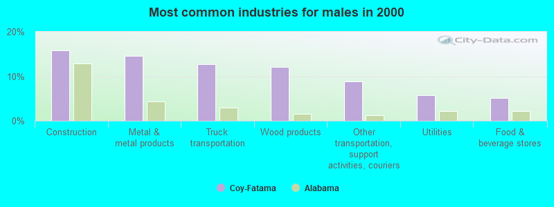
- Construction (15.8%)
- Metal & metal products (14.6%)
- Truck transportation (12.7%)
- Wood products (12.0%)
- Other transportation, support activities, couriers (8.9%)
- Utilities (5.7%)
- Food & beverage stores (5.1%)
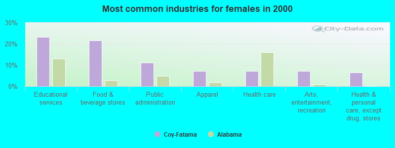
- Educational services (23.2%)
- Food & beverage stores (21.6%)
- Public administration (11.2%)
- Apparel (7.2%)
- Health care (7.2%)
- Arts, entertainment, recreation (7.2%)
- Health & personal care, except drug, stores (6.4%)
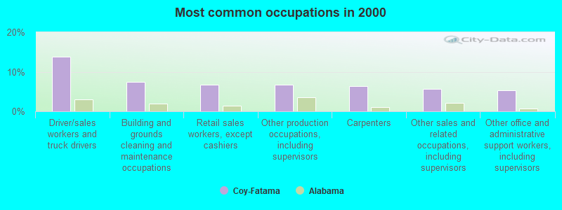
- Driver/sales workers and truck drivers (13.8%)
- Building and grounds cleaning and maintenance occupations (7.4%)
- Retail sales workers, except cashiers (6.7%)
- Other production occupations, including supervisors (6.7%)
- Carpenters (6.4%)
- Other sales and related occupations, including supervisors (5.7%)
- Other office and administrative support workers, including supervisors (5.3%)
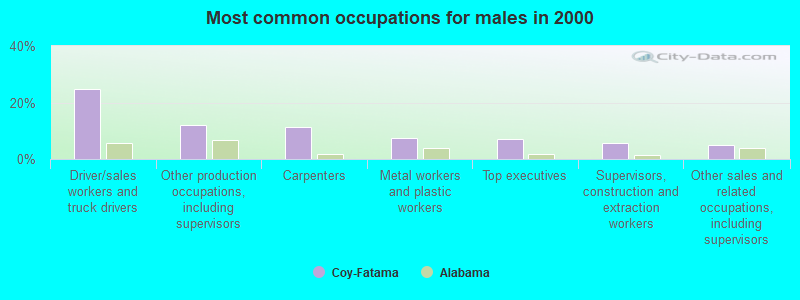
- Driver/sales workers and truck drivers (24.7%)
- Other production occupations, including supervisors (12.0%)
- Carpenters (11.4%)
- Metal workers and plastic workers (7.6%)
- Top executives (7.0%)
- Supervisors, construction and extraction workers (5.7%)
- Other sales and related occupations, including supervisors (5.1%)
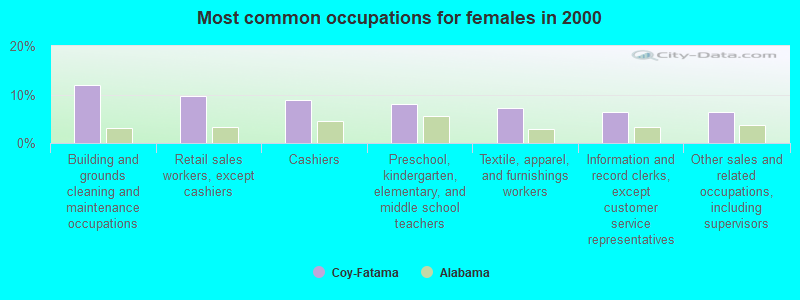
- Building and grounds cleaning and maintenance occupations (12.0%)
- Retail sales workers, except cashiers (9.6%)
- Cashiers (8.8%)
- Preschool, kindergarten, elementary, and middle school teachers (8.0%)
- Textile, apparel, and furnishings workers (7.2%)
- Information and record clerks, except customer service representatives (6.4%)
- Other sales and related occupations, including supervisors (6.4%)
Average climate in Coy-Fatama, Alabama
Based on data reported by over 4,000 weather stations


Tornado activity:
Coy-Fatama-area historical tornado activity is below Alabama state average. It is 16% greater than the overall U.S. average.
On 3/1/2007, a category F4 (max. wind speeds 207-260 mph) tornado 16.9 miles away from the Coy-Fatama place center killed one person and injured 2 people and caused $2 million in damages.
On 4/23/1971, a category F4 tornado 22.8 miles away from the place center caused between $5000 and $50,000 in damages.
Earthquake activity:
Coy-Fatama-area historical earthquake activity is significantly above Alabama state average. It is 80% greater than the overall U.S. average.On 10/24/1997 at 08:35:17, a magnitude 4.9 (4.8 MB, 4.2 MS, 4.9 LG, Depth: 6.2 mi, Class: Light, Intensity: IV - V) earthquake occurred 52.5 miles away from Coy-Fatama center
On 1/18/1999 at 07:00:53, a magnitude 4.8 (4.8 MB, 4.0 LG, Depth: 0.6 mi) earthquake occurred 105.8 miles away from the city center
On 11/7/2004 at 11:20:21, a magnitude 4.3 (4.3 MW, Depth: 3.1 mi) earthquake occurred 62.8 miles away from Coy-Fatama center
On 4/29/2003 at 08:59:39, a magnitude 4.9 (4.4 MB, 4.6 MW, 4.9 LG) earthquake occurred 207.0 miles away from Coy-Fatama center
On 6/24/1975 at 11:11:36, a magnitude 4.5 (4.5 MB) earthquake occurred 130.3 miles away from Coy-Fatama center
On 4/29/2003 at 08:59:39, a magnitude 4.6 (4.6 MW, Depth: 12.3 mi) earthquake occurred 207.0 miles away from Coy-Fatama center
Magnitude types: regional Lg-wave magnitude (LG), body-wave magnitude (MB), surface-wave magnitude (MS), moment magnitude (MW)
Natural disasters:
The number of natural disasters in Wilcox County (16) is near the US average (15).Major Disasters (Presidential) Declared: 8
Emergencies Declared: 5
Causes of natural disasters: Hurricanes: 6, Storms: 6, Floods: 5, Tornadoes: 5, Winds: 2, Drought: 1, Snowfall: 1, Winter Storm: 1, Other: 1 (Note: some incidents may be assigned to more than one category).
Colleges/universities with over 2000 students nearest to Coy-Fatama:
- University of West Alabama (about 69 miles; Livingston, AL; Full-time enrollment: 3,394)
- Alabama State University (about 72 miles; Montgomery, AL; FT enrollment: 5,457)
- James H Faulkner State Community College (about 76 miles; Bay Minette, AL; FT enrollment: 3,703)
- Faulkner University (about 76 miles; Montgomery, AL; FT enrollment: 2,887)
- Auburn University at Montgomery (about 78 miles; Montgomery, AL; FT enrollment: 4,092)
- Troy University (about 84 miles; Troy, AL; FT enrollment: 16,148)
- Shelton State Community College (about 87 miles; Tuscaloosa, AL; FT enrollment: 4,106)
Points of interest:
Notable locations in Coy-Fatama: Dry Fork Plantation (A), Ross Landing (B), Poe Landing (C), Kennedy Landing (D), Henry Landing (E), Black Bluff Landing (F), Coy Volunteer Fire Department (G). Display/hide their locations on the map
Churches in Coy-Fatama include: Mount Gilead Church (A), Mount Zion Church (B), Reeves Chapel (C), New Providence Church (D), Tates Chapel (E), Spiritual Power Church (F), Saint John Church (G), Jordan Church (H), Enon Church (I). Display/hide their locations on the map
Cemeteries: McPherson Cemetery (1), Dees Cemetery (2), Mount Carmel Cemetery (3), New Providence Cemetery (4), Wheeler Quarter Cemetery (5), Tait Cemetery (6), Gravel Hill Cemetery (7). Display/hide their locations on the map
Reservoirs: Ernest L Dyess Pond (A), Brox Mcintosh Lake (B). Display/hide their locations on the map
Streams, rivers, and creeks: Lotties Creek (A), Grey Creek (B), Gravel Creek (C), Dry Creek (D), Burntwood Branch (E), Black Creek (F), Pursley Creek (G). Display/hide their locations on the map
Park in Coy-Fatama: Gulletts Bluff Park (1). Display/hide its location on the map
| This place: | 2.3 people |
| Alabama: | 2.5 people |
| This place: | 63.6% |
| Whole state: | 67.8% |
| This place: | 4.3% |
| Whole state: | 4.7% |
Likely homosexual households (counted as self-reported same-sex unmarried-partner households)
- Lesbian couples: 0.7% of all households
- Gay men: 0.2% of all households
| This place: | 37.9% |
| Whole state: | 16.1% |
| This place: | 21.6% |
| Whole state: | 7.3% |
For population 15 years and over in Coy-Fatama:
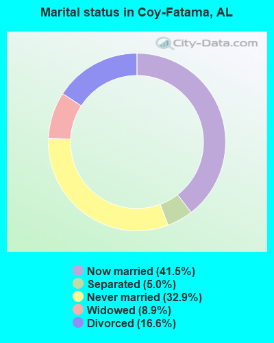
- Never married: 32.9%
- Now married: 41.5%
- Separated: 5.0%
- Widowed: 8.9%
- Divorced: 16.6%
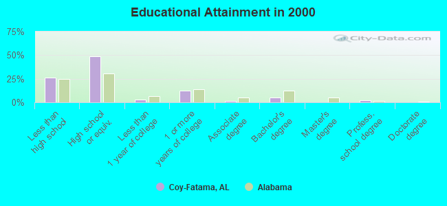
For population 25 years and over in Coy-Fatama:
- High school or higher: 73.5%
- Bachelor's degree or higher: 7.6%
- Graduate or professional degree: 2.3%
- Unemployed: 16.5%
- Mean travel time to work (commute): 42.0 minutes
| Here: | 9.5 |
| Alabama average: | 13.2 |
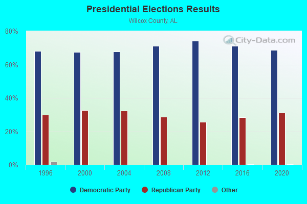
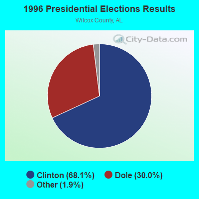
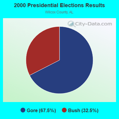
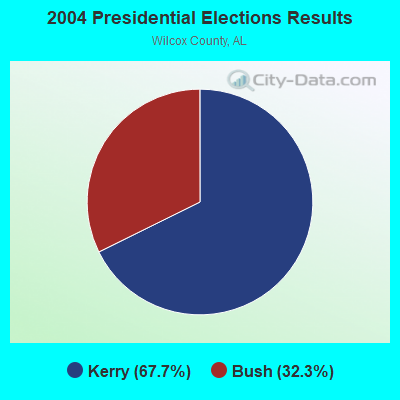
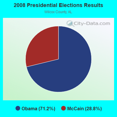
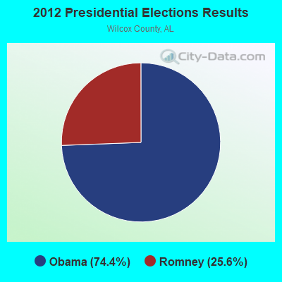
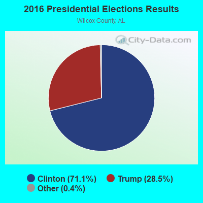
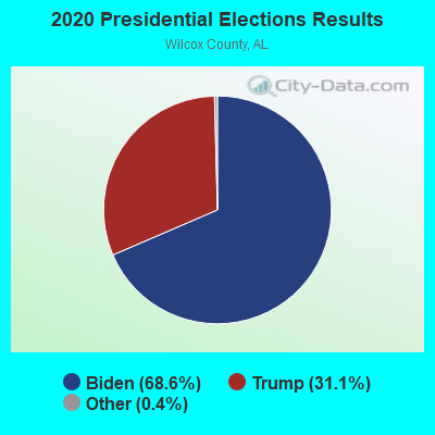
Graphs represent county-level data. Detailed 2008 Election Results
Religion statistics for Coy-Fatama, AL (based on Wilcox County data)
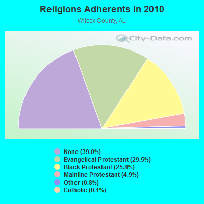
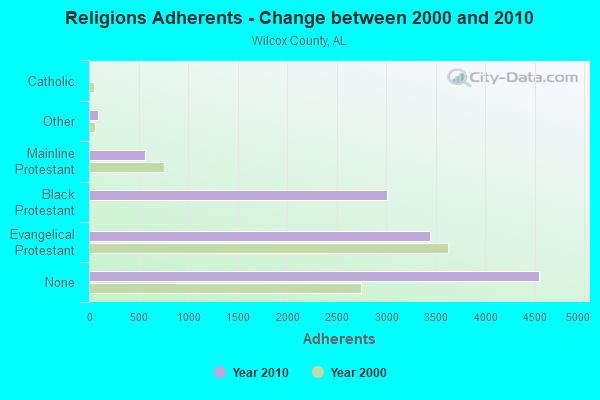
| Religion | Adherents | Congregations |
|---|---|---|
| Evangelical Protestant | 3,442 | 34 |
| Black Protestant | 3,007 | 25 |
| Mainline Protestant | 568 | 8 |
| Other | 95 | 2 |
| Catholic | 12 | 3 |
| None | 4,546 | - |
Food Environment Statistics:
| Here: | 7.05 / 10,000 pop. |
| Alabama: | 1.89 / 10,000 pop. |
| This county: | 0.78 / 10,000 pop. |
| State: | 0.65 / 10,000 pop. |
| Here: | 6.27 / 10,000 pop. |
| Alabama: | 6.32 / 10,000 pop. |
| Wilcox County: | 3.92 / 10,000 pop. |
| Alabama: | 5.75 / 10,000 pop. |
| Wilcox County: | 16.2% |
| Alabama: | 11.8% |
| Wilcox County: | 39.4% |
| State: | 31.7% |
| This county: | 15.6% |
| State: | 13.5% |
Strongest AM radio stations in Coy-Fatama:
- WASG (550 AM; 25 kW; ATMORE, AL; Owner: 550 AM, INC)
- WCOX (1450 AM; 1 kW; CAMDEN, AL; Owner: DOWN HOME BROADCASTING)
- WYNI (930 AM; 5 kW; MONROEVILLE, AL; Owner: MCKISSICK ENTERPRISES)
- WJOX (690 AM; 50 kW; BIRMINGHAM, AL; Owner: CITADEL BROADCASTING COMPANY)
- WDJC (850 AM; 50 kW; BIRMINGHAM, AL; Owner: KIMTRON, INC.)
- WAPI (1070 AM; 50 kW; BIRMINGHAM, AL; Owner: CITADEL BROADCASTING COMPANY)
- WSJC (810 AM; 50 kW; MAGEE, MS; Owner: FAMILY TALK RADIO)
- WJDB (630 AM; 1 kW; THOMASVILLE, AL; Owner: GRIFFIN BROADCASTING CORPORATION)
- WNSI (810 AM; 50 kW; JACKSONVILLE, AL; Owner: UNITED BROADCASTING NETWORK, INC.)
- WEBY (1330 AM; 25 kW; MILTON, FL; Owner: SPINNAKER LICENSE CORPORATION)
- WMSP (740 AM; 10 kW; MONTGOMERY, AL; Owner: CUMULUS LICENSING CORP.)
- WCPC (940 AM; 50 kW; HOUSTON, MS; Owner: WCPC BROADCASTING CO., INC.)
- WNTM (710 AM; 10 kW; MOBILE, AL; Owner: CLEAR CHANNEL BROADCASTING LICENSES, INC.)
Strongest FM radio stations in Coy-Fatama:
- WYVC (102.3 FM; CAMDEN, AL; Owner: DOWN HOME BROADCASTING)
- WKXK (96.7 FM; PINE HILL, AL; Owner: AUTAUGAVILLE RADIO, INC.)
- WAPR (88.3 FM; SELMA, AL; Owner: UA-ASU-TSU EDUCATIONAL RADIO CORP.)
- WINL (98.5 FM; LINDEN, AL; Owner: WEST ALABAMA COMMUNICATIONS, INC.)
- WJDB-FM (95.5 FM; THOMASVILLE, AL; Owner: GRIFFIN BROADCASTING CORPORATION)
- WMBV (91.9 FM; DIXONS MILLS, AL; Owner: THE MOODY BIBLE INSTITUTE OF CHICAGO)
- WPGG (93.3 FM; EVERGREEN, AL; Owner: GULF COAST BROADCASTING COMPANY, INC)
- WHNB (94.5 FM; JACKSON, AL; Owner: CAPITAL ASSETS, INC.)
- WBFZ (105.3 FM; SELMA, AL; Owner: IMANI COMMUNICATIONS CORPORATION, INC)
- WMFC-FM (99.3 FM; MONROEVILLE, AL; Owner: MONROE BROACASTING CO., INC.)
TV broadcast stations around Coy-Fatama:
- WAKA (Channel 8; SELMA, AL; Owner: ALABAMA BROADCASTING PARTNERS)
Coy-Fatama compared to Alabama state average:
- Median household income below state average.
- Median house value significantly below state average.
- Black race population percentage significantly above state average.
- Hispanic race population percentage significantly below state average.
- Median age below state average.
- Foreign-born population percentage significantly below state average.
- Renting percentage significantly below state average.
- Length of stay since moving in significantly above state average.
- Number of rooms per house significantly below state average.
- House age significantly below state average.
- Institutionalized population percentage above state average.
- Number of college students below state average.
- Percentage of population with a bachelor's degree or higher significantly below state average.