Cotter, Arkansas

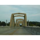
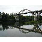
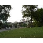
Cotter: Cotter Rainbow Bridge
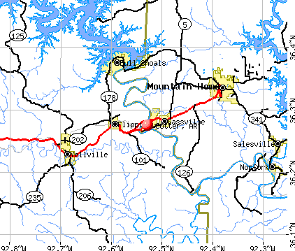
Cotter: Cotter, AR
Cotter: Cotter, AR
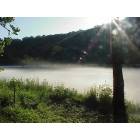
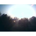
Cotter: Early Morning Mist on the White River
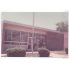
Cotter: POST OFFICE
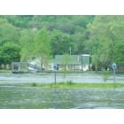
Cotter: Big Spring ParkParking Lot during Flood 2008
Cotter: Cotter, AR
Cotter: my back yard i
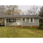
Cotter: home for sale 870-435-2479
- add
your
Submit your own pictures of this city and show them to the world
- OSM Map
- General Map
- Google Map
- MSN Map
Population change since 2000: +0.8%
 |
| Males: 413 | |
| Females: 515 |
| Median resident age: | 63.9 years |
| Arkansas median age: | 38.9 years |
| Cotter: | $34,656 |
| AR: | $55,432 |
Estimated per capita income in 2022: $24,464 (it was $15,893 in 2000)
Cotter city income, earnings, and wages data
Estimated median house or condo value in 2022: $169,061 (it was $60,800 in 2000)
| Cotter: | $169,061 |
| AR: | $179,800 |
Mean prices in 2022: all housing units: $202,969; detached houses: $208,736; mobile homes: $51,951
Median gross rent in 2022: $548.
(12.3% for White Non-Hispanic residents, 50.5% for two or more races residents)
Detailed information about poverty and poor residents in Cotter, AR
Compare current foreclosures near Cotter, AR:
| Photo | Address | Area | Beds / Baths | Price | Details |
|---|---|---|---|---|---|

|
#1
South St
Flippin, AR 72634
|
900 sq. feet
|
1 baths 3 beds |
$119,900
|
show details |

|
#2
Ouachita Ave
Mountain Home, AR 72653
|
1,476 sq. feet
|
2 baths 3 beds |
show details | |

|
#3
County Road 39
Mountain Home, AR 72653
|
4,440 sq. feet
|
4 baths 7 beds |
show details | |

|
#4
Promise Land Rd
Mountain Home, AR 72653
|
958 sq. feet
|
2 baths 3 beds |
show details | |

|
#5
Windbrook St
Mountain Home, AR 72653
|
1,509 sq. feet
|
2 baths 2 beds |
show details | |

|
#6
Bent Oak Ln
Midway, AR 72651
|
- sq. feet
|
2 baths 3 beds |
show details | |

|
#7
Johns Dr
Mountain Home, AR 72653
|
2,163 sq. feet
|
2 baths 2 beds |
show details | |

|
#8
Cochran Dr
Mountain Home, AR 72653
|
836 sq. feet
|
1 baths - beds |
show details | |

|
#9
Kingsberry Dr
Mountain Home, AR 72653
|
2,520 sq. feet
|
2 baths - beds |
show details | |

|
#10
Kathleen St
Mountain Home, AR 72653
|
1,052 sq. feet
|
1 baths - beds |
show details |
| Photo | Address | Area | Beds / Baths | Price | Details |
|---|---|---|---|---|---|

|
#11
Hallmark Cir
Mountain Home, AR 72653
|
1,180 sq. feet
|
1 baths - beds |
show details | |

|
#12
W North St
Mountain Home, AR 72653
|
1,653 sq. feet
|
1 baths - beds |
show details | |

|
#13
Marion County 8013
Yellville, AR 72687
|
1,029 sq. feet
|
1 baths - beds |
show details | |

|
#14
Breckenridge Ct
Mountain Home, AR 72653
|
4,655 sq. feet
|
4 baths - beds |
show details | |

|
#15
Marion County 5004
Valley Springs, AR 72682
|
3,328 sq. feet
|
3 baths - beds |
show details | |

|
#16
Old Rush Creek Rd
Yellville, AR 72687
|
800 sq. feet
|
1 baths - beds |
show details | |

|
#17
Gentry St
Mountain Home, AR 72653
|
1,248 sq. feet
|
1 baths - beds |
show details | |

|
#18
County Road 185
Mountain Home, AR 72653
|
1,108 sq. feet
|
1 baths - beds |
show details | |

|
#19
Overhill Rd
Mountain Home, AR 72653
|
1,406 sq. feet
|
2 baths - beds |
show details | |

|
#20
E 7th St
Mountain Home, AR 72653
|
725 sq. feet
|
1 baths - beds |
show details |
| Photo | Address | Area | Beds / Baths | Price | Details |
|---|---|---|---|---|---|

|
#21
Arkansas Ave
Mountain Home, AR 72653
|
1,367 sq. feet
|
2 baths - beds |
show details | |

|
#22
Elm St
Gassville, AR 72635
|
1,602 sq. feet
|
1 baths - beds |
show details | |

|
#23
Kirby Dr
Mountain Home, AR 72653
|
1,413 sq. feet
|
2 baths - beds |
show details | |

|
#24
Broncos Trl
Flippin, AR 72634
|
1,148 sq. feet
|
3 baths - beds |
show details | |

|
#25
Orchid Ln
Mountain Home, AR 72653
|
2,759 sq. feet
|
2 baths - beds |
show details | |

|
#26
Girard St
Flippin, AR 72634
|
983 sq. feet
|
1 baths - beds |
show details | |

|
#27
S 6th St
Flippin, AR 72634
|
1,226 sq. feet
|
2 baths - beds |
show details | |

|
#28
Crest Loop
Gassville, AR 72635
|
1,368 sq. feet
|
2 baths - beds |
show details | |

|
#29
Highway 62 W
Gassville, AR 72635
|
1,783 sq. feet
|
2 baths - beds |
show details | |

|
#30
Leawood Dr
Midway, AR 72651
|
960 sq. feet
|
1 baths - beds |
show details |
| Photo | Address | Area | Beds / Baths | Price | Details |
|---|---|---|---|---|---|

|
#31
Carolyn Dr
Bull Shoals, AR 72619
|
936 sq. feet
|
1 baths - beds |
show details | |

|
#32
Marion County 6016
Yellville, AR 72687
|
- sq. feet
|
- baths - beds |
show details | |

|
#33
Lake Park Loop
Mountain Home, AR 72653
|
- sq. feet
|
- baths - beds |
show details | |

|
#34
County Road 484
Mountain Home, AR 72653
|
1,216 sq. feet
|
- baths - beds |
show details | |

|
#35
Carmel Rd
Flippin, AR 72634
|
- sq. feet
|
- baths - beds |
show details | |

|
#36
County Road 28
Mountain Home, AR 72653
|
1,904 sq. feet
|
- baths - beds |
show details | |

|
#37
Buford Spur Cir
Mountain Home, AR 72653
|
672 sq. feet
|
- baths - beds |
show details | |

|
#38
Pace Pl
Gassville, AR 72635
|
- sq. feet
|
- baths - beds |
show details | |

|
#39
S Main St Ste 5
Mountain Home, AR 72653
|
- sq. feet
|
- baths - beds |
show details | |

|
#40
County Road 643
Mountain Home, AR 72653
|
- sq. feet
|
- baths - beds |
show details |
| Photo | Address | Area | Beds / Baths | Price | Details |
|---|---|---|---|---|---|

|
#41
E 9th St
Mountain Home, AR 72653
|
3,579 sq. feet
|
- baths - beds |
show details | |

|
#42
Nubbin Ridge Rd Lot 37
Lakeview, AR 72642
|
952 sq. feet
|
- baths - beds |
show details | |

|
#43
Spring St
Mountain Home, AR 72653
|
- sq. feet
|
- baths - beds |
show details | |

|
#44
Ridgemont Way
Mountain Home, AR 72653
|
- sq. feet
|
- baths - beds |
show details | |

|
#45
County Road 27
Mountain Home, AR 72653
|
- sq. feet
|
- baths - beds |
show details | |

|
#46
N Pike St
Summit, AR 72677
|
- sq. feet
|
- baths - beds |
show details | |

|
#47
Wall St, Apt 3
Mountain Home, AR 72653
|
- sq. feet
|
- baths - beds |
show details | |

|
#48
Sir Williams Cir
Mountain Home, AR 72653
|
- sq. feet
|
- baths - beds |
show details | |

|
#49
Marion County 8001
Yellville, AR 72687
|
- sq. feet
|
- baths - beds |
show details | |

|
Check over 1 million property listings on Foreclosure.com!
|
browse all offers | |||


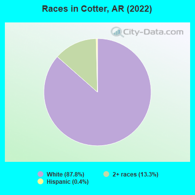
- 88987.8%White alone
- 13513.3%Two or more races
- 40.4%Hispanic
According to our research of Arkansas and other state lists, there was 1 registered sex offender living in Cotter, Arkansas as of April 25, 2024.
The ratio of all residents to sex offenders in Cotter is 996 to 1.
The ratio of registered sex offenders to all residents in this city is lower than the state average.
Type |
2009 |
2010 |
2011 |
2012 |
2013 |
2014 |
2015 |
2016 |
2017 |
2018 |
2019 |
2020 |
2021 |
2022 |
|---|---|---|---|---|---|---|---|---|---|---|---|---|---|---|
| Murders (per 100,000) | 0 (0.0) | 0 (0.0) | 0 (0.0) | 0 (0.0) | 0 (0.0) | 0 (0.0) | 0 (0.0) | 0 (0.0) | 0 (0.0) | 0 (0.0) | 0 (0.0) | 0 (0.0) | 0 (0.0) | 0 (0.0) |
| Rapes (per 100,000) | 0 (0.0) | 0 (0.0) | 0 (0.0) | 0 (0.0) | 0 (0.0) | 0 (0.0) | 0 (0.0) | 0 (0.0) | 0 (0.0) | 0 (0.0) | 1 (106.4) | 0 (0.0) | 2 (209.2) | 0 (0.0) |
| Robberies (per 100,000) | 0 (0.0) | 0 (0.0) | 0 (0.0) | 0 (0.0) | 0 (0.0) | 0 (0.0) | 0 (0.0) | 0 (0.0) | 1 (105.9) | 0 (0.0) | 0 (0.0) | 0 (0.0) | 0 (0.0) | 0 (0.0) |
| Assaults (per 100,000) | 1 (91.1) | 0 (0.0) | 0 (0.0) | 1 (102.6) | 2 (209.6) | 4 (421.5) | 2 (212.5) | 0 (0.0) | 1 (105.9) | 5 (534.8) | 2 (212.8) | 2 (210.7) | 0 (0.0) | 0 (0.0) |
| Burglaries (per 100,000) | 15 (1,366) | 10 (1,031) | 1 (102.4) | 3 (307.7) | 1 (104.8) | 2 (210.7) | 4 (425.1) | 5 (528.0) | 7 (741.5) | 10 (1,070) | 6 (638.3) | 4 (421.5) | 2 (209.2) | 1 (108.2) |
| Thefts (per 100,000) | 19 (1,730) | 21 (2,165) | 5 (511.8) | 8 (820.5) | 15 (1,572) | 8 (843.0) | 18 (1,913) | 19 (2,006) | 17 (1,801) | 11 (1,176) | 10 (1,064) | 15 (1,581) | 8 (836.8) | 2 (216.5) |
| Auto thefts (per 100,000) | 1 (91.1) | 0 (0.0) | 0 (0.0) | 0 (0.0) | 0 (0.0) | 0 (0.0) | 0 (0.0) | 0 (0.0) | 4 (423.7) | 0 (0.0) | 1 (106.4) | 2 (210.7) | 0 (0.0) | 1 (108.2) |
| Arson (per 100,000) | 0 (0.0) | 0 (0.0) | 0 (0.0) | 0 (0.0) | 0 (0.0) | 1 (105.4) | 0 (0.0) | 0 (0.0) | 0 (0.0) | 1 (107.0) | 0 (0.0) | 0 (0.0) | 0 (0.0) | 0 (0.0) |
| City-Data.com crime index | 190.3 | 158.8 | 27.6 | 74.9 | 112.2 | 132.8 | 148.8 | 117.2 | 210.8 | 228.9 | 223.4 | 151.7 | 215.5 | 24.9 |
The City-Data.com crime index weighs serious crimes and violent crimes more heavily. Higher means more crime, U.S. average is 246.1. It adjusts for the number of visitors and daily workers commuting into cities.
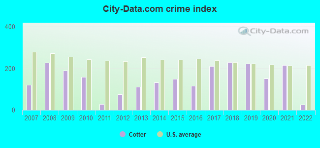
Crime rate in Cotter detailed stats: murders, rapes, robberies, assaults, burglaries, thefts, arson
Full-time law enforcement employees in 2021, including police officers: 3 (3 officers - 3 male; 0 female).
| Officers per 1,000 residents here: | 3.14 |
| Arkansas average: | 2.25 |
 Recent articles from our blog. Our writers, many of them Ph.D. graduates or candidates, create easy-to-read articles on a wide variety of topics.

 | Moving out of Arkansas. (197 replies) |
| 1st trip into Arkansas in search of retirement haven (139 replies) |
| Looking for retirement town for artist (33 replies) |
| Bull Shoals/Mountain Home (24 replies) |
| Looking for relocation info for Marion County (23 replies) |
| Best places for FLY fishing? (6 replies) |
Latest news from Cotter, AR collected exclusively by city-data.com from local newspapers, TV, and radio stations
Ancestries: English (20.2%), American (12.9%), Scottish (9.7%), German (3.9%), Irish (3.4%), Italian (3.2%).
Current Local Time: CST time zone
Elevation: 632 feet
Land area: 2.47 square miles.
Population density: 376 people per square mile (very low).
15 residents are foreign born
| This city: | 1.6% |
| Arkansas: | 2.8% |
Median real estate property taxes paid for housing units with mortgages in 2022: $1,069 (0.5%)
Median real estate property taxes paid for housing units with no mortgage in 2022: $506 (0.4%)
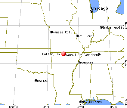
Nearest city with pop. 50,000+: Springfield, MO  (76.3 miles , pop. 151,580).
Nearest city with pop. 200,000+: Memphis, TN (164.4 miles , pop. 650,100).
Nearest city with pop. 1,000,000+: Dallas, TX (341.5 miles , pop. 1,188,580).
Nearest cities:
)Latitude: 36.27 N, Longitude: 92.53 W
Area code commonly used in this area: 870
Single-family new house construction building permits:
- 2022: 8 buildings, average cost: $217,500
- 2021: 13 buildings, average cost: $131,900
- 2020: 7 buildings, average cost: $156,700
- 2019: 1 building, cost: $120,000
- 2018: 4 buildings, average cost: $173,900
- 2017: 3 buildings, average cost: $164,700
- 2016: 3 buildings, average cost: $164,700
- 2014: 1 building, cost: $20,000
- 2010: 2 buildings, average cost: $200,000
- 2009: 2 buildings, average cost: $200,000
- 2008: 3 buildings, average cost: $106,000
- 2007: 11 buildings, average cost: $120,000
- 2006: 7 buildings, average cost: $125,400
- 2005: 7 buildings, average cost: $125,400
- 2004: 5 buildings, average cost: $75,000
- 2003: 4 buildings, average cost: $75,000
- 2002: 5 buildings, average cost: $70,000
- 2001: 4 buildings, average cost: $70,000
- 2000: 4 buildings, average cost: $32,500
- 1999: 5 buildings, average cost: $92,400
- 1998: 3 buildings, average cost: $50,300
- 1997: 4 buildings, average cost: $42,500
| Here: | 4.1% |
| Arkansas: | 3.4% |
- Health care (13.5%)
- Accommodation & food services (8.6%)
- Construction (6.5%)
- Apparel (6.3%)
- Transportation equipment (5.8%)
- Miscellaneous manufacturing (5.3%)
- Electrical & electronic goods merchant wholesalers (4.4%)
- Construction (12.1%)
- Transportation equipment (10.4%)
- Accommodation & food services (6.9%)
- Health care (6.9%)
- Apparel (6.5%)
- Miscellaneous manufacturing (5.2%)
- Plastics & rubber products (3.5%)
- Health care (21.0%)
- Accommodation & food services (10.5%)
- Electrical & electronic goods merchant wholesalers (6.5%)
- Educational services (6.5%)
- Apparel (6.0%)
- Miscellaneous manufacturing (5.5%)
- Food & beverage stores (5.5%)
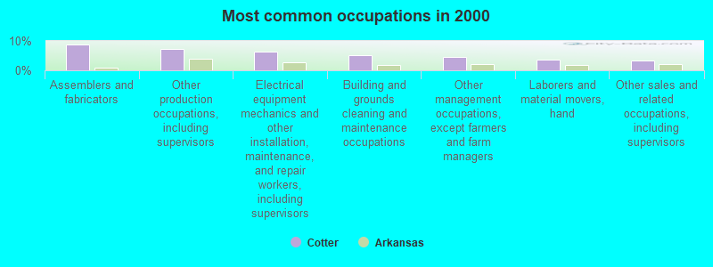
- Assemblers and fabricators (8.8%)
- Other production occupations, including supervisors (7.2%)
- Electrical equipment mechanics and other installation, maintenance, and repair workers, including supervisors (6.5%)
- Building and grounds cleaning and maintenance occupations (5.1%)
- Other management occupations, except farmers and farm managers (4.6%)
- Laborers and material movers, hand (3.7%)
- Other sales and related occupations, including supervisors (3.5%)
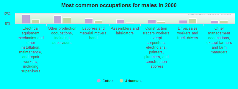
- Electrical equipment mechanics and other installation, maintenance, and repair workers, including supervisors (10.8%)
- Other production occupations, including supervisors (10.0%)
- Laborers and material movers, hand (6.1%)
- Assemblers and fabricators (5.2%)
- Construction traders workers except carpenters, electricians, painters, plumbers, and construction laborers (4.8%)
- Driver/sales workers and truck drivers (3.9%)
- Other management occupations, except farmers and farm managers (3.5%)
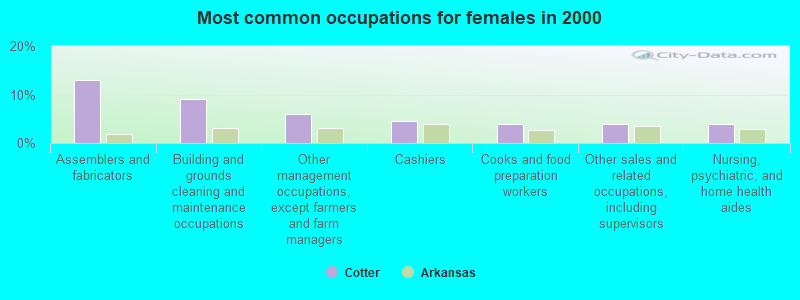
- Assemblers and fabricators (13.0%)
- Building and grounds cleaning and maintenance occupations (9.0%)
- Other management occupations, except farmers and farm managers (6.0%)
- Cashiers (4.5%)
- Cooks and food preparation workers (4.0%)
- Other sales and related occupations, including supervisors (4.0%)
- Nursing, psychiatric, and home health aides (4.0%)
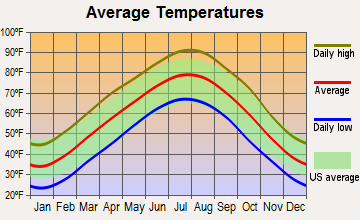
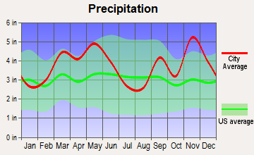
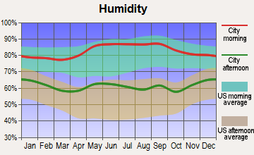
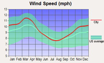
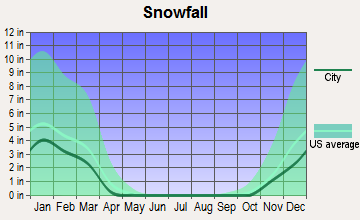
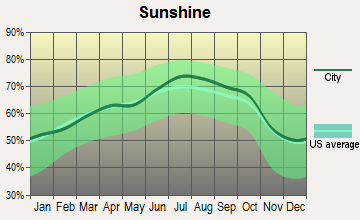
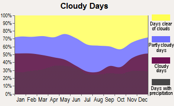
Average climate in Cotter, Arkansas
Based on data reported by over 4,000 weather stations
Tornado activity:
Cotter-area historical tornado activity is slightly below Arkansas state average. It is 65% greater than the overall U.S. average.
On 4/2/1982, a category F4 (max. wind speeds 207-260 mph) tornado 26.7 miles away from the Cotter city center killed 2 people and injured 28 people and caused between $5,000,000 and $50,000,000 in damages.
On 12/14/1971, a category F3 (max. wind speeds 158-206 mph) tornado 4.3 miles away from the city center injured 10 people and caused between $50,000 and $500,000 in damages.
Earthquake activity:
Cotter-area historical earthquake activity is significantly above Arkansas state average. It is 538% greater than the overall U.S. average.On 9/3/2016 at 12:02:44, a magnitude 5.8 (5.8 MW, Depth: 3.5 mi, Class: Moderate, Intensity: VI - VII) earthquake occurred 245.4 miles away from Cotter center
On 11/6/2011 at 03:53:10, a magnitude 5.7 (5.7 MW, Depth: 3.2 mi) earthquake occurred 242.8 miles away from the city center
On 3/25/1976 at 00:41:20, a magnitude 5.0 (4.9 MB, 5.0 LG) earthquake occurred 130.9 miles away from the city center
On 2/28/2011 at 05:00:50, a magnitude 4.7 (4.7 MW, Depth: 2.0 mi, Class: Light, Intensity: IV - V) earthquake occurred 70.3 miles away from Cotter center
On 5/4/2001 at 06:42:12, a magnitude 4.7 (4.2 MB, 4.7 LG, 4.5 LG) earthquake occurred 76.3 miles away from the city center
On 1/21/1982 at 00:33:54, a magnitude 4.7 (4.5 MB, 4.7 LG, 4.5 LG) earthquake occurred 78.5 miles away from Cotter center
Magnitude types: regional Lg-wave magnitude (LG), body-wave magnitude (MB), moment magnitude (MW)
Natural disasters:
The number of natural disasters in Baxter County (16) is near the US average (15).Major Disasters (Presidential) Declared: 11
Emergencies Declared: 3
Causes of natural disasters: Storms: 9, Floods: 8, Tornadoes: 6, Winter Storms: 3, Drought: 1, Hurricane: 1, Ice Storm: 1, Landslide: 1, Wind: 1, Other: 1 (Note: some incidents may be assigned to more than one category).
Hospitals and medical centers near Cotter:
- GASSVILLE NURSING CENTER (Nursing Home, about 1 miles away; GASSVILLE, AR)
- GASSVILLE THERAPY AND LIVING CENTER, INC (Nursing Home, about 2 miles away; GASSVILLE, AR)
- TWIN LAKES THERAPY AND LIVING CENTER, INC (Nursing Home, about 5 miles away; FLIPPIN, AR)
- CARE MANOR NURSING AND REHAB CENTER (Nursing Home, about 9 miles away; MOUNTAIN HOME, AR)
- BAXTER REGIONAL MEDICAL CENTER HOME HEALTH (Home Health Center, about 9 miles away; MOUNTAIN HOME, AR)
- HOSPICE OF THE OZARKS (Hospital, about 9 miles away; MOUNTAIN HOME, AR)
- BAXTER REGIONAL MEDICAL CENTER Acute Care Hospitals (about 9 miles away; MOUNTAIN HOME, AR)
Airports located in Cotter:
- The Valley Airport (61AR) (Runways: 1)
Colleges/universities with over 2000 students nearest to Cotter:
- Arkansas Tech University (about 76 miles; Russellville, AR; Full-time enrollment: 9,038)
- Missouri State University-Springfield (about 77 miles; Springfield, MO; FT enrollment: 16,660)
- Evangel University (about 78 miles; Springfield, MO; FT enrollment: 2,036)
- Ozarks Technical Community College (about 78 miles; Springfield, MO; FT enrollment: 10,356)
- Drury University (about 78 miles; Springfield, MO; FT enrollment: 3,902)
- University of Central Arkansas (about 83 miles; Conway, AR; FT enrollment: 9,972)
- Harding University (about 84 miles; Searcy, AR; FT enrollment: 5,360)
Public high school in Cotter:
- COTTER HIGH SCHOOL (Location: 198 MABEL ST, Grades: 7-12)
Public elementary/middle school in Cotter:
- AMANDA GIST ELEMENTARY SCHOOL (Location: 152 LUCILLE ST, Grades: PK-6)
User-submitted facts and corrections:
- The official city Web site is http://www.cotterarkansas.com
Points of interest:
Notable locations in Cotter: Cotter Volunteer Fire Department (A), Cotter Police Department (B). Display/hide their locations on the map
Cemetery: Cotter Cemetery (1). Display/hide its location on the map
Tourist attraction: White River Artisans School (Cultural Attractions- Events- & Facilities; P. O. Box 308).
Hotels: Rainbow Bridge Lodge (502 Second Street), White Sands Motel (107 Harding Boulevard).
Birthplace of: Joseph Bailey - College basketball player (Arkansas State Indians).
Drinking water stations with addresses in Cotter and their reported violations in the past:
COTTER WATERWORKS (Population served: 1,000, Groundwater):Past monitoring violations:WHITE RIVER CAMPGROUND (Population served: 250, Groundwater under infl of surface water):
- One routine major monitoring violation
Past monitoring violations:LAURELWOOD HOMEOWNERS ASSOCIATION (Population served: 86, Groundwater):
- Monitoring of Treatment (SWTR-Filter) - In JUN-2014
- Monitoring, Turbidity (Enhanced SWTR) - In JUN-2014, Contaminant: IESWTR
- Monitoring of Treatment (SWTR-Filter) - In MAY-2014
- Monitoring, Turbidity (Enhanced SWTR) - In MAY-2014, Contaminant: IESWTR
- Monitoring, Turbidity (Enhanced SWTR) - In DEC-2013, Contaminant: IESWTR. Follow-up actions: St Public Notif requested (JAN-31-2014), St Formal NOV issued (FEB-05-2014)
- 15 routine major monitoring violations
- 22 other older monitoring violations
Past health violations:Past monitoring violations:
- MCL, Monthly (TCR) - In JUN-2014, Contaminant: Coliform
- MCL, Monthly (TCR) - In MAY-2014, Contaminant: Coliform
- MCL, Monthly (TCR) - In NOV-2009, Contaminant: Coliform. Follow-up actions: St Public Notif requested (JAN-07-2010), St Public Notif received (JAN-21-2010), St AO (w/o penalty) issued (JUN-25-2010), St Compliance achieved (AUG-02-2011)
- MCL, Monthly (TCR) - In AUG-2009, Contaminant: Coliform. Follow-up actions: St Public Notif requested (OCT-07-2009), St AO (w/o penalty) issued (JUN-25-2010), St Compliance achieved (AUG-02-2011)
- MCL, Monthly (TCR) - In JUL-2009, Contaminant: Coliform. Follow-up actions: St Public Notif requested (SEP-10-2009), St Public Notif received (SEP-28-2009), St AO (w/o penalty) issued (JUN-25-2010), St Compliance achieved (AUG-02-2011)
- Monitoring, Repeat Major (TCR) - In MAY-2008, Contaminant: Coliform (TCR). Follow-up actions: St Public Notif requested (JUL-07-2008), St Public Notif received (JUL-24-2008), St Compliance achieved (JUL-09-2009)
- Follow-up Or Routine LCR Tap M/R - In DEC-31-1998, Contaminant: Lead and Copper Rule. Follow-up actions: St Compliance achieved (NOV-09-2011)
- One minor monitoring violation
| This city: | 2.2 people |
| Arkansas: | 2.5 people |
| This city: | 59.7% |
| Whole state: | 67.6% |
| This city: | 5.1% |
| Whole state: | 5.7% |
Likely homosexual households (counted as self-reported same-sex unmarried-partner households)
- Lesbian couples: 0.4% of all households
- Gay men: 0.2% of all households
For population 15 years and over in Cotter:
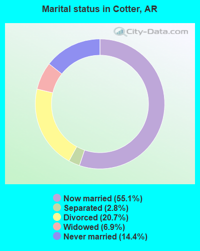
- Never married: 14.4%
- Now married: 55.1%
- Separated: 2.8%
- Widowed: 6.9%
- Divorced: 20.7%
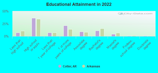
For population 25 years and over in Cotter:
- High school or higher: 91.7%
- Bachelor's degree or higher: 17.3%
- Graduate or professional degree: 6.3%
- Unemployed: 5.9%
- Mean travel time to work (commute): 19.2 minutes
| Here: | 8.4 |
| Arkansas average: | 11.4 |
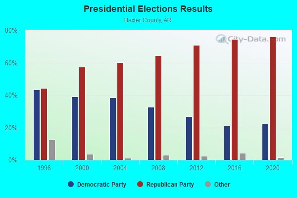
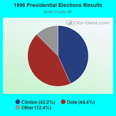
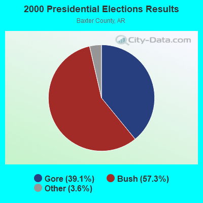
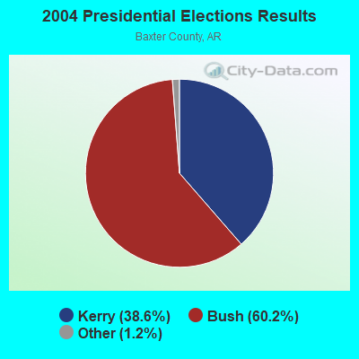
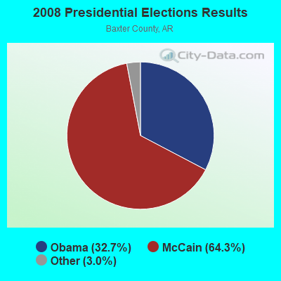
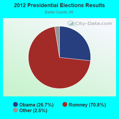
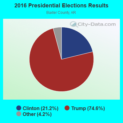
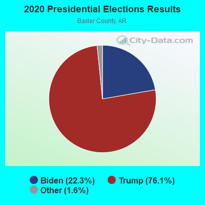
Graphs represent county-level data. Detailed 2008 Election Results
Religion statistics for Cotter, AR (based on Baxter County data)
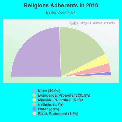
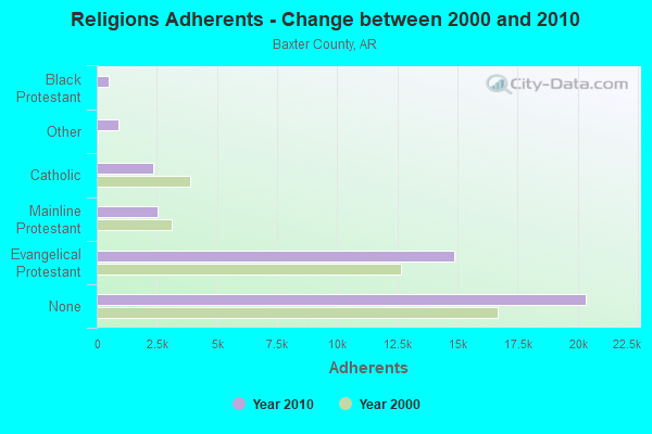
| Religion | Adherents | Congregations |
|---|---|---|
| Evangelical Protestant | 14,884 | 74 |
| Mainline Protestant | 2,528 | 9 |
| Catholic | 2,359 | 1 |
| Other | 888 | 6 |
| Black Protestant | 499 | 2 |
| None | 20,355 | - |
Food Environment Statistics:
| Baxter County: | 1.67 / 10,000 pop. |
| State: | 2.02 / 10,000 pop. |
| Here: | 0.24 / 10,000 pop. |
| State: | 0.25 / 10,000 pop. |
| Here: | 0.24 / 10,000 pop. |
| Arkansas: | 0.59 / 10,000 pop. |
| Baxter County: | 6.93 / 10,000 pop. |
| Arkansas: | 4.94 / 10,000 pop. |
| Baxter County: | 11.46 / 10,000 pop. |
| Arkansas: | 6.66 / 10,000 pop. |
| This county: | 11.9% |
| Arkansas: | 9.8% |
| Here: | 26.1% |
| Arkansas: | 29.1% |
| Baxter County: | 10.2% |
| Arkansas: | 13.6% |
Health and Nutrition:
| This city: | 45.2% |
| State: | 48.2% |
| Cotter: | 37.2% |
| Arkansas: | 44.2% |
| Cotter: | 28.4 |
| Arkansas: | 28.9 |
| This city: | 23.8% |
| Arkansas: | 21.6% |
| Here: | 10.8% |
| Arkansas: | 11.3% |
| This city: | 6.8 |
| Arkansas: | 6.8 |
| Here: | 33.5% |
| State: | 34.0% |
| This city: | 48.4% |
| Arkansas: | 54.4% |
| Here: | 73.4% |
| Arkansas: | 78.0% |
More about Health and Nutrition of Cotter, AR Residents
| Local government employment and payroll (March 2022) | |||||
| Function | Full-time employees | Monthly full-time payroll | Average yearly full-time wage | Part-time employees | Monthly part-time payroll |
|---|---|---|---|---|---|
| Other Government Administration | 2 | $6,771 | $40,626 | 8 | $4,364 |
| Police Protection - Officers | 2 | $5,071 | $30,426 | 0 | $0 |
| Water Supply | 1 | $4,251 | $51,012 | 0 | $0 |
| Financial Administration | 1 | $3,676 | $44,112 | 0 | $0 |
| Streets and Highways | 0 | $0 | 2 | $6,196 | |
| Totals for Government | 6 | $19,769 | $39,538 | 10 | $10,559 |
Cotter government finances - Expenditure in 2017 (per resident):
- Construction - Central Staff Services: $41,000 ($44.18)
Regular Highways: $40,000 ($43.10)
Local Fire Protection: $21,000 ($22.63)
Water Utilities: $10,000 ($10.78)
Police Protection: $7,000 ($7.54)
- Current Operations - Central Staff Services: $186,000 ($200.43)
Water Utilities: $178,000 ($191.81)
Police Protection: $89,000 ($95.91)
Regular Highways: $57,000 ($61.42)
Solid Waste Management: $55,000 ($59.27)
Local Fire Protection: $32,000 ($34.48)
Parks and Recreation: $13,000 ($14.01)
Judicial and Legal Services: $11,000 ($11.85)
Financial Administration: $9,000 ($9.70)
Miscellaneous Commercial Activities - Other: $8,000 ($8.62)
- Intergovernmental to Local - Other - Sewerage: $114,000 ($122.84)
Other - Judicial and Legal Services: $56,000 ($60.34)
- Total Salaries and Wages: $379,000 ($408.41)
- Water Utilities - Interest on Debt: $10,000 ($10.78)
Cotter government finances - Revenue in 2017 (per resident):
- Charges - Sewerage: $98,000 ($105.60)
Solid Waste Management: $53,000 ($57.11)
Miscellaneous Commercial Activities: $5,000 ($5.39)
Parks and Recreation: $1,000 ($1.08)
- Local Intergovernmental - General Local Government Support: $156,000 ($168.10)
Other: $5,000 ($5.39)
- Miscellaneous - Fines and Forfeits: $56,000 ($60.34)
General Revenue - Other: $15,000 ($16.16)
Donations From Private Sources: $12,000 ($12.93)
Sale of Property: $11,000 ($11.85)
Interest Earnings: $3,000 ($3.23)
- Revenue - Water Utilities: $205,000 ($220.91)
- State Intergovernmental - Highways: $64,000 ($68.97)
General Local Government Support: $60,000 ($64.66)
Other: $33,000 ($35.56)
- Tax - General Sales and Gross Receipts: $171,000 ($184.27)
Property: $107,000 ($115.30)
Public Utilities Sales: $32,000 ($34.48)
Occupation and Business License - Other: $2,000 ($2.16)
Cotter government finances - Debt in 2017 (per resident):
- Long Term Debt - Beginning Outstanding - Unspecified Public Purpose: $436,000 ($469.83)
Outstanding Unspecified Public Purpose: $392,000 ($422.41)
Retired Unspecified Public Purpose: $44,000 ($47.41)
Cotter government finances - Cash and Securities in 2017 (per resident):
- Other Funds - Cash and Securities: $1,157,000 ($1246.77)
Strongest AM radio stations in Cotter:
- KCGS (960 AM; 5 kW; MARSHALL, AR; Owner: SOUTHLAND BROADCASTING CORPORATION)
- KTLO (1240 AM; 1 kW; MOUNTAIN HOME, AR; Owner: KTLO LIMITED PARTNERSHIP)
- KGHT (880 AM; 50 kW; SHERIDAN, AR; Owner: METROPOLITAN RADIO GROUP, INC.)
- KAAY (1090 AM; 50 kW; LITTLE ROCK, AR; Owner: CITADEL BROADCASTING COMPANY)
- KNWA (1600 AM; 5 kW; BELLEFONTE, AR; Owner: HARRISON RADIO STATIONS, INC.)
- WCRV (640 AM; 50 kW; COLLIERVILLE, TN; Owner: BOTT BROADCASTING COMPANY/TENNESSEE)
- KWTO (560 AM; 5 kW; SPRINGFIELD, MO; Owner: KWTO, INC.)
- WDIA (1070 AM; 50 kW; MEMPHIS, TN; Owner: CLEAR CHANNEL BROADCASTING LICENSES, INC.)
- KGFL (1110 AM; daytime; 5 kW; CLINTON, AR; Owner: KING-SULIVAN RADIO)
- WGSF (1030 AM; 50 kW; MEMPHIS, TN; Owner: FLINN BROADCASTING CORPORATION)
- KRMG (740 AM; 50 kW; TULSA, OK; Owner: CXR HOLDINGS, INC.)
- KFAQ (1170 AM; 50 kW; TULSA, OK; Owner: JOURNAL BROADCAST CORPORATION)
- KMTL (760 AM; daytime; 10 kW; SHERWOOD, AR; Owner: GEORGE V. DOMERESE)
Strongest FM radio stations in Cotter:
- KCTT-FM (101.7 FM; YELLVILLE, AR; Owner: KTLO LIMITED PARTNERSHIP)
- KCMH (91.5 FM; MOUNTAIN HOME, AR; Owner: CHRISTIAN B/C GROUP OF MT. HOME, INC)
- KPFM (105.5 FM; MOUNTAIN HOME, AR; Owner: MOUNTAIN HOME RADIO STATION, INC.)
- KTLO-FM (97.9 FM; MOUNTAIN HOME, AR; Owner: KTLO LIMITED PARTNERSHIP)
- KOMT (107.5 FM; MOUNTAIN HOME, AR; Owner: MAC PARTNERS)
- KKTZ (93.5 FM; LAKEVIEW, AR; Owner: JOHN M. DOWDY)
- KCWD (96.1 FM; HARRISON, AR; Owner: HARRISON RADIO STATIONS, INC.)
- KBCN-FM (104.3 FM; MARSHALL, AR; Owner: PEARSON B/CASTING OF MARSHALL, INC.)
- KMAC (99.7 FM; GAINESVILLE, MO; Owner: PEARSON B/CASTING OF G/VILLE, INC)
- KHOZ-FM (102.9 FM; HARRISON, AR; Owner: HARRISON BROADCASTING CORPORATION)
- KFFB (106.1 FM; FAIRFIELD BAY, AR; Owner: FREEDOM BROADCAST, INC)
TV broadcast stations around Cotter:
- KEMV (Channel 6; MOUNTAIN VIEW, AR; Owner: ARKANSAS EDUCATIONAL TELEVISION COMMISSION)
- KWBM (Channel 31; HARRISON, AR; Owner: R.S. COMMUNICATIONS LTD. PARTNERSHIP)
- K41HC (Channel 41; MOUNTAIN HOME, AR; Owner: TRINITY BROADCASTING NETWORK)
Cotter fatal accident list:
Apr 29, 1999 01:45 PM, Us-62-10, Vehicles: 2, Persons: 2, Fatalities: 1, Drunk persons involved: 1
Sep 11, 1997 11:15 AM, Us-62-10, Vehicles: 2, Persons: 2, Fatalities: 1, Drunk persons involved: 1
Nov 4, 1994 03:30 PM, 62-10, Vehicles: 2, Persons: 3, Fatalities: 2
- National Bridge Inventory (NBI) Statistics
- 15Number of bridges
- 476ft / 145mTotal length
- $2,827,000Total costs
- 57,800Total average daily traffic
- 3,272Total average daily truck traffic
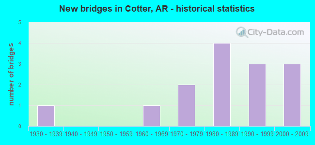
- New bridges - historical statistics
- 11930-1939
- 11960-1969
- 21970-1979
- 41980-1989
- 31990-1999
- 32000-2009
FCC Registered Antenna Towers:
11 (See the full list of FCC Registered Antenna Towers in Cotter)FCC Registered Microwave Towers:
1- FLIPPIN AR, .25 Km N Of Us Hwy 62 Near (Lat: 36.288333 Lon: -92.510556), Type: Gtower, Structure height: 98.4 m, Overall height: 99.4 m, Call Sign: WQQJ944,
Assigned Frequencies: 10835.0 MHz, 10835.0 MHz, 10835.0 MHz, Grant Date: 01/10/2013, Expiration Date: 01/10/2023, Cancellation Date: 03/18/2023, Certifier: Chris Harris, Registrant: Conterra Ultra Broadband, LLC, 2101 Rexford Rd, Ste 200e, Charlotte, NC 28211, Phone: (704) 936-1801, Fax: (704) 936-1801, Email:
FCC Registered Amateur Radio Licenses:
12 (See the full list of FCC Registered Amateur Radio Licenses in Cotter)FAA Registered Aircraft:
28 (See the full list of FAA Registered Aircraft in Cotter)2002 - 2018 National Fire Incident Reporting System (NFIRS) incidents
- Fire incident types reported to NFIRS in Cotter, AR
- 12051.1%Outside Fires
- 7331.1%Structure Fires
- 2510.6%Mobile Property/Vehicle Fires
- 177.2%Other
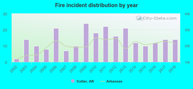 According to the data from the years 2002 - 2018 the average number of fire incidents per year is 14. The highest number of fires - 24 took place in 2009, and the least - 2 in 2002. The data has an increasing trend.
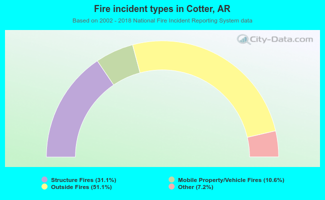 When looking into fire subcategories, the most reports belonged to: Outside Fires (51.1%), and Structure Fires (31.1%).
| Most common first names in Cotter, AR among deceased individuals | ||
| Name | Count | Lived (average) |
|---|---|---|
| Robert | 18 | 75.3 years |
| William | 15 | 72.3 years |
| James | 15 | 64.2 years |
| Charles | 14 | 73.4 years |
| George | 10 | 77.2 years |
| John | 8 | 82.0 years |
| Thomas | 7 | 76.1 years |
| Frank | 6 | 73.8 years |
| Ruth | 6 | 75.8 years |
| Harold | 5 | 81.6 years |
| Most common last names in Cotter, AR among deceased individuals | ||
| Last name | Count | Lived (average) |
|---|---|---|
| Williams | 7 | 73.0 years |
| Smith | 6 | 73.0 years |
| Cox | 5 | 72.4 years |
| Cole | 4 | 81.5 years |
| Adkerson | 4 | 69.0 years |
| Poynter | 4 | 79.0 years |
| Rice | 4 | 81.5 years |
| Walker | 4 | 72.7 years |
| White | 4 | 71.0 years |
| Holland | 3 | 74.4 years |
Cotter compared to Arkansas state average:
- Median household income below state average.
- Unemployed percentage below state average.
- Black race population percentage significantly below state average.
- Hispanic race population percentage significantly below state average.
- Median age significantly above state average.
- Foreign-born population percentage significantly below state average.
- Length of stay since moving in significantly above state average.
- House age above state average.