Cope, Colorado

Cope: Cope Sale
Cope: Cope Farm Supply

Cope: Cope Auto Wrecker
Cope: Cope Nutrina
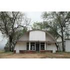
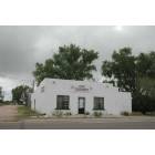
Cope: Cope Antiques
Cope: Cope Corner Store
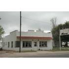
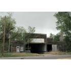
Cope: Cope Western Steak House
Cope: Cope Food Store
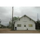
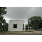
Cope: Cope Post Office
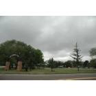
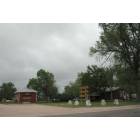
Cope: Cope City Park

Cope: Cope Garage
- see
17
more - add
your
Submit your own pictures of this place and show them to the world
- OSM Map
- General Map
- Google Map
- MSN Map

| Males: 308 | |
| Females: 280 |
| Median resident age: | 40.9 years |
| Colorado median age: | 34.3 years |
Zip code: 80801
| Cope: | $59,785 |
| CO: | $89,302 |
Estimated per capita income in 2022: $40,708 (it was $20,934 in 2000)
Cope CCD income, earnings, and wages data
Estimated median house or condo value in 2022: $204,986 (it was $66,300 in 2000)
| Cope: | $204,986 |
| CO: | $531,100 |
Mean prices in 2022: all housing units: $255,772; detached houses: $264,748; townhouses or other attached units: $251,768; mobile homes: $150,027
Detailed information about poverty and poor residents in Cope, CO


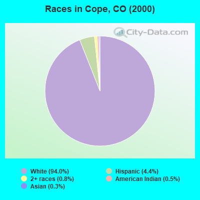
- 59594.0%White alone
- 284.4%Hispanic
- 50.8%Two or more races
- 30.5%American Indian alone
- 20.3%Asian alone
According to our research of Colorado and other state lists, there was 1 registered sex offender living in Cope, Colorado as of May 11, 2024.
The ratio of all residents to sex offenders in Cope is 588 to 1.
The ratio of registered sex offenders to all residents in this city is lower than the state average.
 Recent articles from our blog. Our writers, many of them Ph.D. graduates or candidates, create easy-to-read articles on a wide variety of topics.
Current Local Time: MST time zone
Elevation: 4426 feet
Land area: 613.9 square miles.
Population density: 1.0 people per square mile (very low).

| Cope CCD: | 0.7% ($489) |
| Colorado: | 0.7% ($1,132) |
Nearest city with pop. 50,000+: Aurora, CO  (95.3 miles , pop. 276,393).
Nearest city with pop. 1,000,000+: Dallas, TX (594.5 miles , pop. 1,188,580).
Nearest cities:
), Latitude: 39.78 N, Longitude: 103.02 W
Area code: 970

| Here: | 2.2% |
| Colorado: | 3.2% |
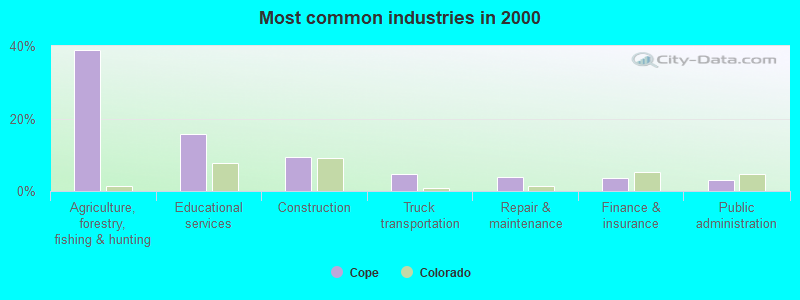
- Agriculture, forestry, fishing & hunting (38.9%)
- Educational services (15.8%)
- Construction (9.5%)
- Truck transportation (4.6%)
- Repair & maintenance (3.9%)
- Finance & insurance (3.5%)
- Public administration (3.2%)
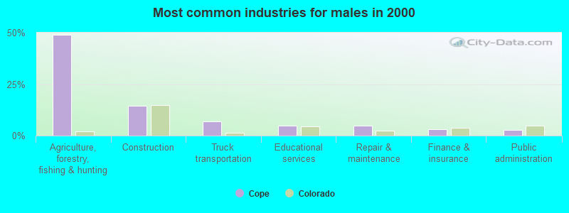
- Agriculture, forestry, fishing & hunting (48.9%)
- Construction (14.4%)
- Truck transportation (6.9%)
- Educational services (4.8%)
- Repair & maintenance (4.8%)
- Finance & insurance (3.2%)
- Public administration (2.7%)
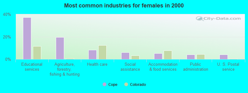
- Educational services (37.1%)
- Agriculture, forestry, fishing & hunting (19.6%)
- Health care (8.2%)
- Social assistance (6.2%)
- Accommodation & food services (5.2%)
- Public administration (4.1%)
- U. S. Postal service (4.1%)
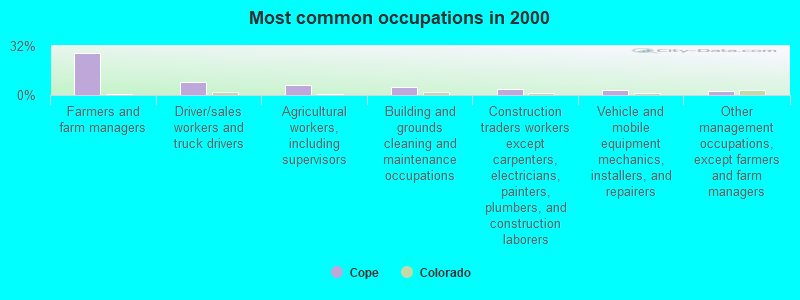
- Farmers and farm managers (27.4%)
- Driver/sales workers and truck drivers (8.4%)
- Agricultural workers, including supervisors (6.3%)
- Building and grounds cleaning and maintenance occupations (4.9%)
- Construction traders workers except carpenters, electricians, painters, plumbers, and construction laborers (4.2%)
- Vehicle and mobile equipment mechanics, installers, and repairers (3.2%)
- Other management occupations, except farmers and farm managers (2.8%)
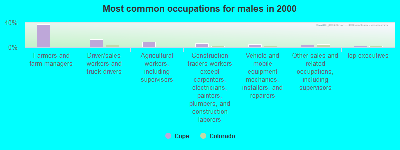
- Farmers and farm managers (37.2%)
- Driver/sales workers and truck drivers (12.8%)
- Agricultural workers, including supervisors (9.0%)
- Construction traders workers except carpenters, electricians, painters, plumbers, and construction laborers (6.4%)
- Vehicle and mobile equipment mechanics, installers, and repairers (4.8%)
- Other sales and related occupations, including supervisors (4.3%)
- Top executives (2.1%)
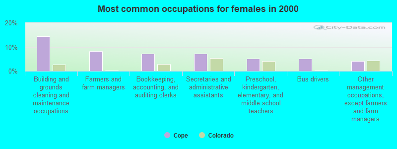
- Building and grounds cleaning and maintenance occupations (14.4%)
- Farmers and farm managers (8.2%)
- Bookkeeping, accounting, and auditing clerks (7.2%)
- Secretaries and administrative assistants (7.2%)
- Preschool, kindergarten, elementary, and middle school teachers (5.2%)
- Bus drivers (5.2%)
- Other management occupations, except farmers and farm managers (4.1%)
Average climate in Cope, Colorado
Based on data reported by over 4,000 weather stations


Tornado activity:
Cope-area historical tornado activity is above Colorado state average. It is 17% greater than the overall U.S. average.
On 7/21/1993, a category F3 (max. wind speeds 158-206 mph) tornado 12.7 miles away from the Cope place center injured 6 people and caused between $5000 and $50,000 in damages.
On 5/30/1996, a category F3 tornado 12.9 miles away from the place center caused $300,000 in damages.
Earthquake activity:
Cope-area historical earthquake activity is significantly above Colorado state average. It is 568% greater than the overall U.S. average.On 8/18/1959 at 06:37:13, a magnitude 7.7 (7.7 UK, Class: Major, Intensity: VIII - XII) earthquake occurred 512.3 miles away from the city center, causing $26,000,000 total damage
On 10/18/1984 at 15:30:23, a magnitude 5.5 (5.4 MB, 5.1 MS, 5.5 ML, Class: Moderate, Intensity: VI - VII) earthquake occurred 224.4 miles away from Cope center
On 8/23/2011 at 05:46:18, a magnitude 5.3 (5.3 MW, Depth: 2.5 mi) earthquake occurred 208.8 miles away from the city center
On 8/10/2005 at 22:08:22, a magnitude 5.0 (5.0 MW, Depth: 3.1 mi) earthquake occurred 219.2 miles away from the city center
On 8/10/2005 at 22:08:22, a magnitude 5.0 (5.0 MB, 4.7 MS, 5.0 MW) earthquake occurred 219.3 miles away from Cope center
On 9/3/2016 at 12:02:44, a magnitude 5.8 (5.8 MW, Depth: 3.5 mi) earthquake occurred 404.5 miles away from Cope center
Magnitude types: body-wave magnitude (MB), local magnitude (ML), surface-wave magnitude (MS), moment magnitude (MW)
Natural disasters:
The number of natural disasters in Washington County (11) is smaller than the US average (15).Major Disasters (Presidential) Declared: 7
Emergencies Declared: 3
Causes of natural disasters: Floods: 6, Storms: 6, Landslides: 3, Mudslides: 3, Snows: 2, Tornadoes: 2, Fire: 1, Heavy Rain: 1, Hurricane: 1, Other: 1 (Note: some incidents may be assigned to more than one category).
Colleges/universities with over 2000 students nearest to Cope:
- Community College of Aurora (about 95 miles; Aurora, CO; Full-time enrollment: 4,730)
- University of Northern Colorado (about 99 miles; Greeley, CO; FT enrollment: 11,469)
- Jones International University (about 100 miles; Centennial, CO; FT enrollment: 2,556)
- Colorado State University-Global Campus (about 101 miles; Greenwood Village, CO; FT enrollment: 3,642)
- Aims Community College (about 103 miles; Greeley, CO; FT enrollment: 3,598)
- University of Denver (about 104 miles; Denver, CO; FT enrollment: 9,621)
- Emily Griffith Technical College (about 106 miles; Denver, CO; FT enrollment: 2,460)
Points of interest:
Notable locations in Cope: Donald Ranch (A), Price Ranch (B), Payne Hill (C), Cope Fire Department (D). Display/hide their locations on the map
Cemeteries: Thurman Cemetery (1), Lee Cemetery (2), Cope Community Cemetery (3). Display/hide their locations on the map
Rivers and creeks: Jack Creek (A), Gordon Creek (B), North Fork Arikaree River (C). Display/hide their locations on the map
| This place: | 2.5 people |
| Colorado: | 2.5 people |
| This place: | 69.9% |
| Whole state: | 63.9% |
| This place: | 2.8% |
| Whole state: | 6.5% |
No gay or lesbian households reported
| This place: | 21.2% |
| Whole state: | 9.3% |
| This place: | 7.7% |
| Whole state: | 4.1% |
For population 15 years and over in Cope:
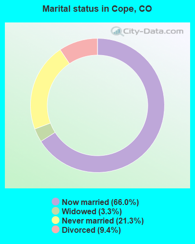
- Never married: 21.3%
- Now married: 66.0%
- Separated: 0.0%
- Widowed: 3.3%
- Divorced: 9.4%
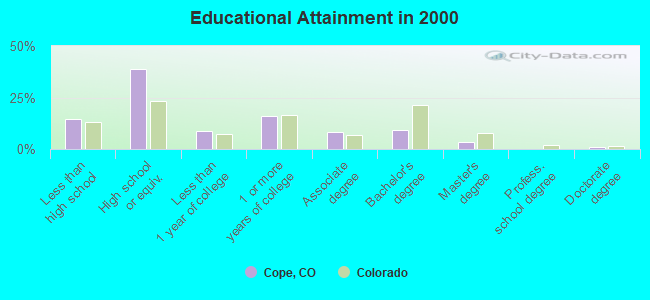
For population 25 years and over in Cope:
- High school or higher: 85.3%
- Bachelor's degree or higher: 13.5%
- Graduate or professional degree: 4.5%
- Unemployed: 1.7%
- Mean travel time to work (commute): 20.4 minutes
| Here: | 9.0 |
| Colorado average: | 11.8 |
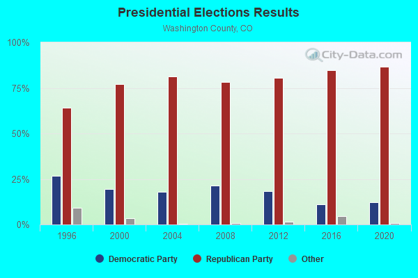
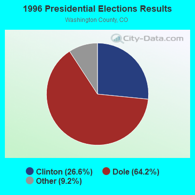
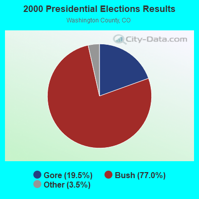
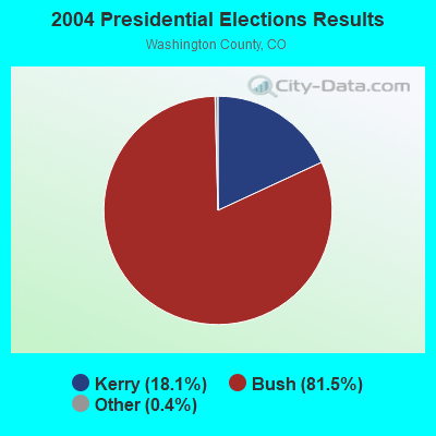
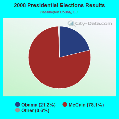
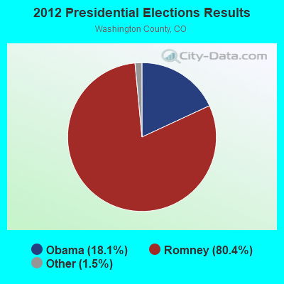
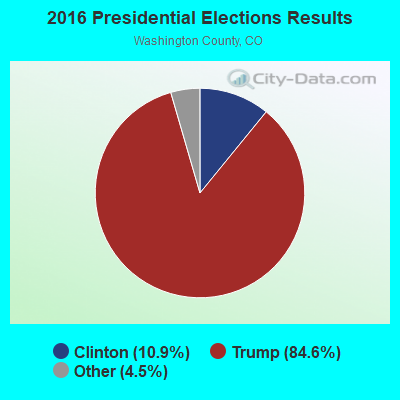
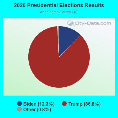
Graphs represent county-level data. Detailed 2008 Election Results
Religion statistics for Cope, CO (based on Washington County data)
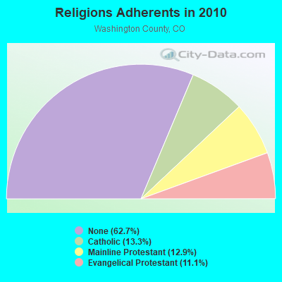
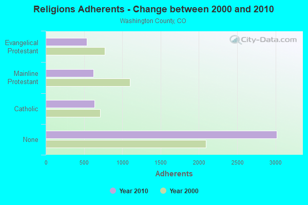
| Religion | Adherents | Congregations |
|---|---|---|
| Catholic | 639 | 1 |
| Mainline Protestant | 622 | 6 |
| Evangelical Protestant | 534 | 13 |
| None | 3,019 | - |
Food Environment Statistics:
| Washington County: | 2.17 / 10,000 pop. |
| Colorado: | 1.50 / 10,000 pop. |
| Here: | 6.52 / 10,000 pop. |
| Colorado: | 3.13 / 10,000 pop. |
| This county: | 10.86 / 10,000 pop. |
| Colorado: | 8.99 / 10,000 pop. |
| Washington County: | 7.3% |
| Colorado: | 5.3% |
| Here: | 19.8% |
| Colorado: | 18.4% |
Strongest AM radio stations in Cope:
- KSIR (1010 AM; 25 kW; BRUSH, CO; Owner: JMS BROADCASTING, LLC)
- KLTT (670 AM; 50 kW; COMMERCE CITY, CO; Owner: KLZ RADIO, INC.)
- KOA (850 AM; 50 kW; DENVER, CO; Owner: JACOR BROADCASTING OF COLORADO, INC.)
- KMXA (1090 AM; 50 kW; AURORA, CO; Owner: ENTRAVISION HOLDINGS, LLC)
- KKZN (760 AM; 50 kW; THORNTON, CO; Owner: JACOR BROADCASTING OF COLORADO, INC.)
- KIMB (1260 AM; 50 kW; KIMBALL, NE; Owner: G & L INVESTMENTS, LLC)
- KLMO (1060 AM; 30 kW; LONGMONT, CO; Owner: PILGRIM COMMUNICATIONS, INC.)
- KRDZ (1440 AM; 5 kW; WRAY, CO; Owner: MEDIA LOGIC, LLC.)
- KCUV (1510 AM; 25 kW; LITTLETON, CO; Owner: PEOPLE WIRELESS, INC.)
- KRVN (880 AM; 50 kW; LEXINGTON, NE; Owner: NEBRASKA RURAL RADIO ASSOCIATION)
- KCBR (1040 AM; daytime; 15 kW; MONUMENT, CO; Owner: KLZ RADIO, INC.)
- KRKS (990 AM; 10 kW; DENVER, CO; Owner: SALEM MEDIA OF COLORADO, INC.)
- KNRC (1150 AM; 10 kW; ENGLEWOOD, CO; Owner: NRC BROADCASTING, INC.)
Strongest FM radio stations in Cope:
- KBRU-FM (101.7 FM; FORT MORGAN, CO; Owner: ON-AIR FAMILY, LLC)
- KAVD (103.1 FM; LIMON, CO; Owner: THE MEADOWLARK GROUP, INC.)
- KNEC (100.9 FM; YUMA, CO; Owner: ARNOLD BROADCASTING CO INC)
- K204BH (88.7 FM; YUMA, CO; Owner: COMMUNITY RADIO FOR NORTHERN COLORADO)
- K220IJ (91.9 FM; YUMA, CO; Owner: CALVARY CHAPEL OF TWIN FALLS, INC.)
TV broadcast stations around Cope:
- K47FT (Channel 47; ANTON * SW WASH CTY, CO; Owner: BOARD OF WASHINGTON COUNTY COMMISSIONERS)
- K49EX (Channel 49; ANTON & SW WASH CTY, CO; Owner: BOARD OF WASHINGTON COUNTY COMMISSIONERS)
- K55IB (Channel 55; ANTON & SW WASH CTY, CO; Owner: BOARD OF WASHINGTON COUNTY COMMISSIONERS)
- K57IL (Channel 57; ANTON, CO; Owner: REGION 1 TRANSLATOR ASSOCIATION)
- K45FD (Channel 45; ANTON & SW WASH CTY, CO; Owner: BOARD OF WASHINGTON COUNTY COMMISSIONERS)
- K32AB (Channel 32; YUMA, CO; Owner: REGION 1 TRANSLATOR ASSOCIATION)
- K34AC (Channel 34; YUMA, CO; Owner: REGION 1 TRANSLATOR ASSOCIATION)
- K36AC (Channel 36; YUMA, CO; Owner: REGION 1 TRANSLATOR ASSOCIATION)
- K38AD (Channel 38; YUMA, CO; Owner: REGION 1 TRANSLATOR ASSOCIATION)
- K40CG (Channel 40; YUMA, CO; Owner: REGION 1 TRANSLATOR ASSOCIATION)
FCC Registered Cell Phone Towers:
1 (See the full list of FCC Registered Cell Phone Towers in Cope)FCC Registered Antenna Towers:
12 (See the full list of FCC Registered Antenna Towers)FCC Registered Broadcast Land Mobile Towers:
4- 9 Mi Due North (Lat: 39.918333 Lon: -102.751889), Call Sign: KVE697,
Assigned Frequencies: 151.580 MHz, Grant Date: 02/12/1998, Expiration Date: 03/09/2003, Cancellation Date: 06/08/2003, Registrant: Dennis L Christianson, Route 3 Box 13, Cope, CO 80812
- 1/2 Mi E 1 Mi N 1 1/2 Mi E 1/2 Mi (Lat: 39.781944 Lon: -102.642139), Call Sign: WSW419,
Assigned Frequencies: 152.900 MHz, Grant Date: 05/24/2005, Expiration Date: 05/23/2015, Cancellation Date: 07/25/2015, Registrant: Stone Communications LLC, 422 Main Ave, Flagler, CO 80815, Phone: (719) 765-4481, Fax: (719) 765-4409, Email:
- 1 1/2 Mi E Hwy 36 From Cope (Lat: 39.598611 Lon: -102.814389), Call Sign: WSW420,
Assigned Frequencies: 152.900 MHz, Grant Date: 05/24/2005, Expiration Date: 05/23/2015, Cancellation Date: 07/25/2015, Registrant: Stone Communications LLC, 422 Main Ave, Flagler, CO 80815, Phone: (719) 765-4481, Fax: (719) 765-4409, Email:
- Lat: 39.605250 Lon: -102.827306, Call Sign: WRPV673,
Assigned Frequencies: 159.832 MHz, Grant Date: 03/23/2022, Expiration Date: 03/23/2032, Certifier: Dylan Dean, Registrant: Complete Wireless Technologies, 621-C Innovation Circle, Windsor, CO 80550, Phone: (970) 686-7530, Email:
FCC Registered Microwave Towers:
3- Cope, Lat: 39.482528 Lon: -103.039000, Call Sign: WQAX234,
Assigned Frequencies: 956.443 MHz, 956.443 MHz, Grant Date: 07/23/2014, Expiration Date: 08/23/2024, Certifier: Joseph Listengart, Registrant: Sourcegas Distribution LLC, 655 East Millsap Road, Suite 104, Fayetteville, AR 72703, Phone: (877) 404-7207, Fax: (479) 582-7802, Email:
- COPE, 45506 Cr7 (Lat: 39.669750 Lon: -102.848806), Type: Pole, Structure height: 15.8 m, Call Sign: WQYM293,
Assigned Frequencies: 10875.0 MHz, Grant Date: 11/03/2016, Expiration Date: 11/03/2026, Certifier: Thomas W Burnett, Registrant: Ne Colorado Cellular, Inc., 1220 West Platte Ave, Fort Morgan, CO 80701, Phone: (970) 867-6767, Fax: (970) 867-3589, Email:
- DN02807A, S26, T4s, R50w, 6th Principal (Lat: 39.671056 Lon: -102.943528), Type: Mast, Structure height: 76.2 m, Overall height: 79.8 m, Call Sign: WRVR901,
Assigned Frequencies: 6330.66 MHz, 6330.66 MHz, 6330.66 MHz, 6330.66 MHz, 6330.66 MHz, 6330.66 MHz, 6330.66 MHz, 6330.66 MHz, 6330.66 MHz, 6330.66 MHz, 6330.66 MHz, 6330.66 MHz, Grant Date: 12/28/2022, Expiration Date: 12/28/2032, Certifier: Jenny Knopf, Registrant: T-Mobile Usa, Inc., 12920 Se 38th Street, Bellevue, WA 98006, Phone: (425) 383-8401, Fax: (425) 383-4040, Email:
FCC Registered Amateur Radio Licenses:
2- Call Sign: KC0KNC, Licensee ID: L00350818, Grant Date: 04/26/2001, Expiration Date: 04/26/2011, Cancellation Date: 04/27/2013, Certifier: Alan B Fullmer, Registrant: Alan B Fullmer, 45450 Madison Ave, Cope, CO 80812
- Call Sign: KD0KFL, Licensee ID: L01546542, Grant Date: 02/09/2010, Expiration Date: 02/09/2020, Cancellation Date: 02/10/2022, Certifier: Hilary E House Jr, Registrant: Hilary E House Jr, 45365 Us Hwy 36, Cope, CO 80812
FAA Registered Aircraft:
6- Aircraft: ROCKWELL INTERNATIONAL S-2R (Category: Land, Weight: Up to 12,499 Pounds, Speed: 82 mph), Engine: AMA/EXPR UNKNOWN ENG (Turbo-prop)
N-Number: 123AG, N123AG, N-123AG, Serial Number: 2282R, Year manufactured: 1976, Airworthiness Date: 09/24/2003, Certificate Issue Date: 05/14/2020
Registrant (LLC): Fly-By LLC, Po Box 53, Cope, CO 80812
Deregistered: Cancel Date: 07/24/2012, Exported to: Mexico - Aircraft: CHAMPION 7KCAB (Category: Land, Seats: 2, Weight: Up to 12,499 Pounds, Speed: 90 mph), Engine: LYCOMING IO-320 SERIES (150 HP) (Reciprocating)
N-Number: 2606G, N2606G, N-2606G, Serial Number: 51, Year manufactured: 1967, Airworthiness Date: 05/31/1968, Certificate Issue Date: 06/11/2020
Registrant (LLC): Fly-By LLC, Po Box 53, Cope, CO 80812 - Aircraft: AYRES CORPORATION S2R-G6 (Category: Land, Weight: Up to 12,499 Pounds), Engine: AIRESEARCH TPE331 SERIES (904 HP) (Turbo-prop)
N-Number: 3083Z, N3083Z, N-3083Z, Serial Number: G6-122, Year manufactured: 1995, Airworthiness Date: 03/31/1995, Certificate Issue Date: 06/11/2020
Registrant (LLC): Fly-By LLC, Po Box 53, Cope, CO 80812 - Aircraft: BEECH A36TC (Category: Land, Seats: 6, Weight: Up to 12,499 Pounds), Engine: Reciprocating
N-Number: 45BL, N45BL, N-45BL, Serial Number: EA-101, Year manufactured: 1980, Certificate Issue Date: 11/21/2016
Registrant (LLC): King Air LLC, 6490 County Road Uu, Cope, CO 80812 - Aircraft: ROCKWELL INTERNATIONAL S-2R (Category: Land, Weight: Up to 12,499 Pounds, Speed: 82 mph), Engine: P&W CANADA PT6A-41 (850 HP) (Turbo-prop)
N-Number: 4995X, N4995X, N-4995X, Serial Number: 5040R, Year manufactured: 1975, Airworthiness Date: 03/24/2017, Certificate Issue Date: 06/16/2020
Registrant (LLC): Fly-By LLC, Po Box 53, Cope, CO 80812 - Aircraft: CESSNA 175 (Category: Land, Seats: 4, Weight: Up to 12,499 Pounds, Speed: 105 mph), Engine: AMA/EXPR UNKNOWN ENG (Reciprocating)
N-Number: 6507E, N6507E, N-6507E, Serial Number: 56007, Year manufactured: 1959, Airworthiness Date: 08/13/2002, Certificate Issue Date: 09/17/2013
Registrant (Co-Owned): William W Thomason, 9540 Rr Yy, Cope, CO 80812, Other Owners: Darwin D Thomason, Brent W Thomason
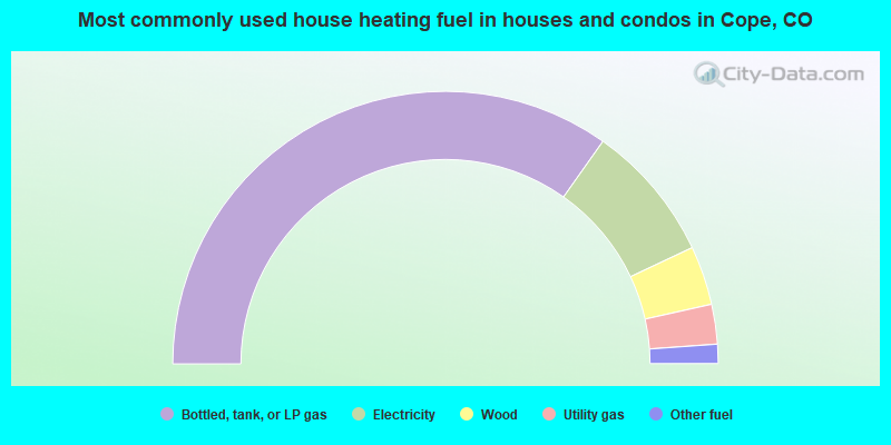
- 69.6%Bottled, tank, or LP gas
- 16.4%Electricity
- 7.0%Wood
- 4.7%Utility gas
- 2.3%Other fuel
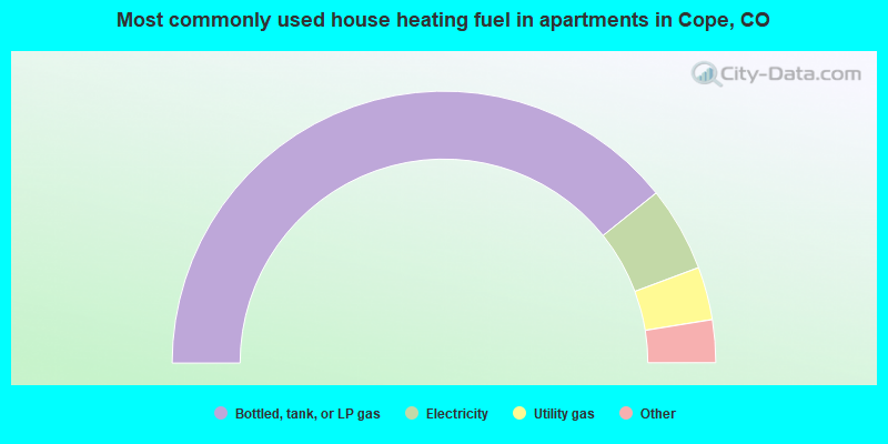
- 78.5%Bottled, tank, or LP gas
- 10.1%Electricity
- 6.3%Utility gas
- 2.5%Wood
- 2.5%Other fuel
Cope compared to Colorado state average:
- Median house value significantly below state average.
- Unemployed percentage significantly below state average.
- Black race population percentage significantly below state average.
- Hispanic race population percentage significantly below state average.
- Foreign-born population percentage significantly below state average.
- Length of stay since moving in significantly above state average.
- Number of rooms per house significantly below state average.
- House age significantly below state average.
- Number of college students significantly below state average.
- Percentage of population with a bachelor's degree or higher significantly below state average.
Cope on our top lists:
- #35 on the list of "Top 101 cities with the most cars per house, population 500+"