Cooks Point, Texas
Submit your own pictures of this place and show them to the world
- OSM Map
- General Map
- Google Map
- MSN Map

| Males: 691 | |
| Females: 682 |
| Median resident age: | 39.2 years |
| Texas median age: | 32.3 years |
Zip code: 77836
| Cooks Point: | $84,568 |
| TX: | $72,284 |
Estimated per capita income in 2022: $36,960 (it was $15,528 in 2000)
Cooks Point CCD income, earnings, and wages data
Estimated median house or condo value in 2022: $344,872 (it was $102,300 in 2000)
| Cooks Point: | $344,872 |
| TX: | $275,400 |
Mean prices in 2022: all housing units: $251,374; detached houses: $303,599; townhouses or other attached units: $424,305; mobile homes: $120,336; occupied boats, rvs, vans, etc.: $30,218
Detailed information about poverty and poor residents in Cooks Point, TX
Compare current foreclosures near Cooks Point, TX:
| Photo | Address | Area | Beds / Baths | Price | Details |
|---|---|---|---|---|---|

|
#1
Markley Dr
Bryan, TX 77807
|
- sq. feet
|
2 baths 4 beds |
show details | |

|
#2
Esther Blvd
Bryan, TX 77802
|
3,652 sq. feet
|
3 baths 4 beds |
show details | |

|
#3
Hazel St
Bryan, TX 77803
|
984 sq. feet
|
2 baths 3 beds |
show details | |

|
#4
Sundown Rd
Caldwell, TX 77836
|
2,160 sq. feet
|
1 baths 4 beds |
show details | |

|
#5
Mountain Wind Loop
Bryan, TX 77807
|
1,180 sq. feet
|
2 baths 3 beds |
show details | |

|
#6
Windsor Dr
Bryan, TX 77802
|
2,038 sq. feet
|
2 baths 3 beds |
show details | |

|
#7
E 31st St
Bryan, TX 77802
|
1,233 sq. feet
|
1 baths 2 beds |
show details | |

|
#8
Valley View Dr
Bryan, TX 77802
|
2,842 sq. feet
|
2 baths 4 beds |
show details | |

|
#9
Homestead St
Bryan, TX 77803
|
1,449 sq. feet
|
1 baths 2 beds |
show details | |

|
#10
E 28th St
Bryan, TX 77802
|
1,054 sq. feet
|
1 baths 2 beds |
show details |
| Photo | Address | Area | Beds / Baths | Price | Details |
|---|---|---|---|---|---|

|
#11
County Road 269 W
Somerville, TX 77879
|
5,085 sq. feet
|
- baths - beds |
show details | |

|
#12
E Mlking Dr
Caldwell, TX 77836
|
- sq. feet
|
- baths - beds |
show details | |

|
#13
E 27th St
Bryan, TX 77803
|
1,568 sq. feet
|
- baths - beds |
show details | |

|
#14
Sentinel Ct
Bryan, TX 77803
|
- sq. feet
|
- baths - beds |
show details | |

|
#15
Mariposa Ct
Bryan, TX 77808
|
- sq. feet
|
- baths - beds |
show details | |

|
#16
Cherry St
College Station, TX 77840
|
- sq. feet
|
- baths - beds |
show details | |

|
#17
Tabor Rd
Bryan, TX 77808
|
2,500 sq. feet
|
- baths - beds |
show details | |

|
#18
Peterson Cir
Bryan, TX 77802
|
- sq. feet
|
- baths - beds |
show details | |

|
#19
County Road 405
Somerville, TX 77879
|
- sq. feet
|
- baths - beds |
show details | |

|
#20
Castle Ave
Bryan, TX 77808
|
- sq. feet
|
- baths - beds |
show details |
| Photo | Address | Area | Beds / Baths | Price | Details |
|---|---|---|---|---|---|

|
#21
Gopher Ln
Bryan, TX 77808
|
1,792 sq. feet
|
- baths - beds |
show details | |

|
#22
Franklin Dr
Bryan, TX 77801
|
- sq. feet
|
- baths - beds |
show details | |

|
#23
Baker Ave
Bryan, TX 77803
|
- sq. feet
|
- baths - beds |
show details | |

|
#24
County Road 328
Milano, TX 76556
|
- sq. feet
|
- baths - beds |
show details | |

|
#25
E Pin Oak Ln
Caldwell, TX 77836
|
- sq. feet
|
- baths - beds |
show details | |

|
#26
County Road 269
Somerville, TX 77879
|
- sq. feet
|
- baths - beds |
show details | |

|
#27
Mount Hope
Bryan, TX 77807
|
- sq. feet
|
- baths - beds |
show details | |

|
#28
Vincent Rd
College Station, TX 77845
|
- sq. feet
|
- baths - beds |
show details | |

|
#29
Hedley Pl
Bryan, TX 77807
|
- sq. feet
|
- baths - beds |
show details | |

|
#30
Cartwright St
Bryan, TX 77807
|
- sq. feet
|
- baths - beds |
show details |
| Photo | Address | Area | Beds / Baths | Price | Details |
|---|---|---|---|---|---|

|
#31
White Creek Rd
College Station, TX 77845
|
- sq. feet
|
- baths - beds |
show details | |

|
#32
Groesbeck St
Bryan, TX 77803
|
- sq. feet
|
- baths - beds |
show details | |

|
#33
Pine Dr
Caldwell, TX 77836
|
936 sq. feet
|
- baths - beds |
show details | |

|
#34
Yellowhouse Cir Apt B
College Station, TX 77840
|
- sq. feet
|
- baths - beds |
show details | |

|
#35
Staunton Dr
Bryan, TX 77803
|
- sq. feet
|
- baths - beds |
show details | |

|
#36
Live Oak Cir
Bryan, TX 77807
|
- sq. feet
|
- baths - beds |
show details | |

|
#37
Markley Dr
Bryan, TX 77807
|
- sq. feet
|
- baths - beds |
show details | |

|
#38
E 24th St
Bryan, TX 77803
|
- sq. feet
|
- baths - beds |
show details | |

|
#39
Bellview Cir
Bryan, TX 77803
|
- sq. feet
|
- baths - beds |
show details | |

|
#40
New York St
Bryan, TX 77803
|
- sq. feet
|
- baths - beds |
show details |
| Photo | Address | Area | Beds / Baths | Price | Details |
|---|---|---|---|---|---|

|
Check over 1 million property listings on Foreclosure.com!
|
browse all offers | |||
| Photo | Address | Area | Beds / Baths | Price | Details |
|---|

- 1,03375.3%White alone
- 18013.1%Black alone
- 14810.8%Hispanic
- 60.4%American Indian alone
- 30.2%Two or more races
- 10.07%Asian alone
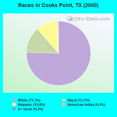
Races in Cooks Point detailed stats: ancestries, foreign born residents, place of birth
 Recent articles from our blog. Our writers, many of them Ph.D. graduates or candidates, create easy-to-read articles on a wide variety of topics.
Current Local Time: CST time zone
Elevation: 343 feet
Land area: 98.8 square miles.
Population density: 14 people per square mile (very low).

| Cooks Point CCD: | 0.7% ($738) |
| Texas: | 1.8% ($1,393) |
Nearest city with pop. 50,000+: Bryan, TX  (15.0 miles , pop. 65,660).
Nearest city with pop. 200,000+: Austin, TX (71.1 miles , pop. 656,562).
Nearest city with pop. 1,000,000+: Houston, TX (93.3 miles , pop. 1,953,631).
Nearest cities:
), ), ), ), )Latitude: 30.60 N, Longitude: 96.61 W
Area code commonly used in this area: 979

| Here: | 3.2% |
| Texas: | 3.5% |
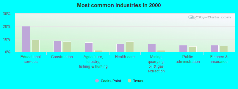
- Educational services (20.2%)
- Construction (8.5%)
- Agriculture, forestry, fishing & hunting (7.5%)
- Health care (6.5%)
- Mining, quarrying, oil & gas extraction (6.2%)
- Public administration (5.5%)
- Finance & insurance (5.3%)
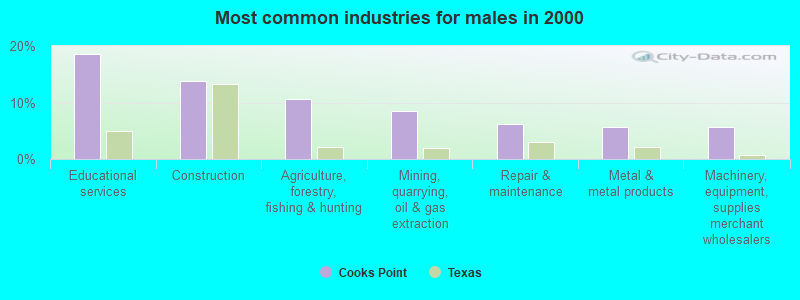
- Educational services (18.6%)
- Construction (13.9%)
- Agriculture, forestry, fishing & hunting (10.6%)
- Mining, quarrying, oil & gas extraction (8.6%)
- Repair & maintenance (6.2%)
- Metal & metal products (5.6%)
- Machinery, equipment, supplies merchant wholesalers (5.6%)
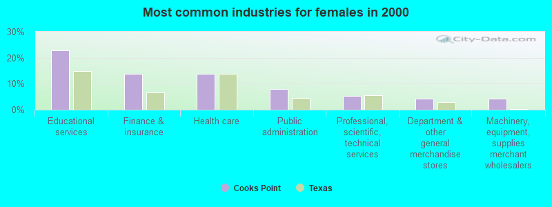
- Educational services (22.7%)
- Finance & insurance (13.7%)
- Health care (13.7%)
- Public administration (8.1%)
- Professional, scientific, technical services (5.2%)
- Department & other general merchandise stores (4.3%)
- Machinery, equipment, supplies merchant wholesalers (4.3%)
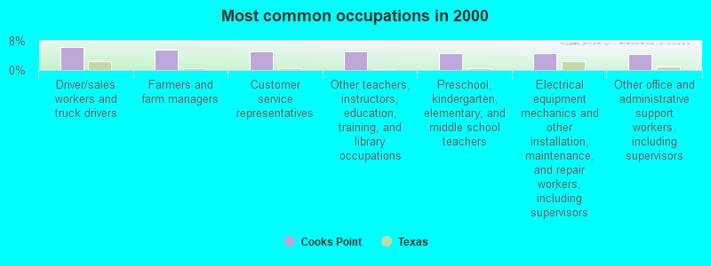
- Driver/sales workers and truck drivers (6.2%)
- Farmers and farm managers (5.6%)
- Customer service representatives (5.1%)
- Other teachers, instructors, education, training, and library occupations (5.1%)
- Preschool, kindergarten, elementary, and middle school teachers (4.5%)
- Electrical equipment mechanics and other installation, maintenance, and repair workers, including supervisors (4.5%)
- Other office and administrative support workers, including supervisors (4.4%)

- Driver/sales workers and truck drivers (10.0%)
- Farmers and farm managers (9.1%)
- Electrical equipment mechanics and other installation, maintenance, and repair workers, including supervisors (7.4%)
- Postsecondary teachers (5.6%)
- Supervisors, construction and extraction workers (5.3%)
- Other teachers, instructors, education, training, and library occupations (4.4%)
- Vehicle and mobile equipment mechanics, installers, and repairers (4.4%)
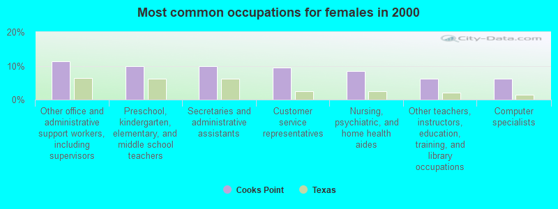
- Other office and administrative support workers, including supervisors (11.4%)
- Preschool, kindergarten, elementary, and middle school teachers (10.0%)
- Secretaries and administrative assistants (10.0%)
- Customer service representatives (9.5%)
- Nursing, psychiatric, and home health aides (8.5%)
- Other teachers, instructors, education, training, and library occupations (6.2%)
- Computer specialists (6.2%)
Average climate in Cooks Point, Texas
Based on data reported by over 4,000 weather stations


(lower is better)
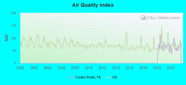
Air Quality Index (AQI) level in 2022 was 63.9. This is about average.
| City: | 63.9 |
| U.S.: | 72.6 |
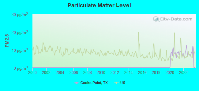
Particulate Matter (PM2.5) [µg/m3] level in 2022 was 7.93. This is about average. Closest monitor was 14.7 miles away from the city center.
| City: | 7.93 |
| U.S.: | 8.11 |
Tornado activity:
Cooks Point-area historical tornado activity is near Texas state average. It is 34% greater than the overall U.S. average.
On 3/20/1957, a category F3 (max. wind speeds 158-206 mph) tornado 11.2 miles away from the Cooks Point place center injured 2 people and caused between $5000 and $50,000 in damages.
On 5/10/1959, a category F3 tornado 11.8 miles away from the place center injured 7 people and caused between $500 and $5000 in damages.
Earthquake activity:
Cooks Point-area historical earthquake activity is significantly above Texas state average. It is 20% smaller than the overall U.S. average.On 10/20/2011 at 12:24:41, a magnitude 4.8 (4.8 MW, Depth: 3.1 mi, Class: Light, Intensity: IV - V) earthquake occurred 149.0 miles away from the city center
On 5/17/2012 at 08:12:00, a magnitude 4.8 (4.8 MW, Depth: 3.1 mi) earthquake occurred 161.0 miles away from Cooks Point center
On 6/16/1978 at 11:46:54, a magnitude 5.3 (4.4 MB, 4.6 UK, 5.3 ML, Class: Moderate, Intensity: VI - VII) earthquake occurred 296.7 miles away from the city center
On 4/14/1995 at 00:32:56, a magnitude 5.7 (5.6 MB, 5.7 MS, 5.7 MW, Depth: 11.1 mi) earthquake occurred 403.7 miles away from the city center
On 4/9/1993 at 12:29:19, a magnitude 4.3 (4.1 MB, 4.3 LG, Depth: 3.1 mi) earthquake occurred 153.6 miles away from Cooks Point center
On 9/2/2013 at 23:51:15, a magnitude 4.3 (4.3 MW, Depth: 2.9 mi) earthquake occurred 157.5 miles away from the city center
Magnitude types: regional Lg-wave magnitude (LG), body-wave magnitude (MB), local magnitude (ML), surface-wave magnitude (MS), moment magnitude (MW)
Natural disasters:
The number of natural disasters in Burleson County (15) is near the US average (15).Major Disasters (Presidential) Declared: 8
Emergencies Declared: 5
Causes of natural disasters: Storms: 6, Hurricanes: 5, Floods: 4, Fires: 3, Tornadoes: 3, Wind: 1, Other: 1 (Note: some incidents may be assigned to more than one category).
Hospitals and medical centers near Cooks Point:
- CALDWELL HEALTH AND REHAB CTR (Nursing Home, about 8 miles away; CALDWELL, TX)
- COPPERAS HOLLOW NURSING AND REHABILITATION CENTER (Nursing Home, about 8 miles away; CALDWELL, TX)
- BURLESON MEMORIAL HOSPITAL (Hospital, about 9 miles away; CALDWELL, TX)
- BURLESON ST JOSEPH HEALTH CENTER Critical Access Hospitals (about 9 miles away; CALDWELL, TX)
- HOSPICE BRAZOS VALLEY INC (Hospital, about 15 miles away; BRYAN, TX)
- FAMILY TREE (Hospital, about 16 miles away; BRYAN, TX)
- FRESENIUS MEDICAL CARE BRYAN DIALYSIS (Dialysis Facility, about 16 miles away; BRYAN, TX)
Colleges/universities with over 2000 students nearest to Cooks Point:
- Texas A & M University-College Station (about 16 miles; College Station, TX; Full-time enrollment: 46,550)
- Blinn College (about 33 miles; Brenham, TX; FT enrollment: 8,959)
- Prairie View A & M University (about 51 miles; Prairie View, TX; FT enrollment: 7,517)
- Temple College (about 55 miles; Temple, TX; FT enrollment: 3,796)
- University of Mary Hardin-Baylor (about 61 miles; Belton, TX; FT enrollment: 2,885)
- Sam Houston State University (about 64 miles; Huntsville, TX; FT enrollment: 16,233)
- Austin Community College District (about 67 miles; Austin, TX; FT enrollment: 25,957)
Points of interest:
Notable locations in Cooks Point: Cooks Point (A), Ennis Public Library (B), Cooks Point Volunteer Fire Department (C). Display/hide their locations on the map
Churches in Cooks Point include: Oldham Church (A), San Salvador Church (B), Cooks Point Church (C), John the Baptist Church (D), Macedonia Church (E), Zion Hill Church (F), Saint Mathews Church (G), New Hope Church (H), New Tabor Brethren Church (I). Display/hide their locations on the map
Cemeteries: Elizabeth Chapel Cemetery (1), Elizabeth Cemetery (2), Kramer Cemetery (3), Slovak Cemetery (4), Hix Cemetery (5), Carr Cemetery (6), Salem Cemetery (7). Display/hide their locations on the map
Lakes and reservoirs: Black Lake (A), Woodrow Lake (B), Garwood Lake (C), Gibbs Lake (D), Garwood Lake (E), Lake Woodrow (F). Display/hide their locations on the map
Streams, rivers, and creeks: Storm Branch (A), Sweetgum Branch (B), Cedar Creek (C), Rocky Branch (D), Porter Branch (E), Jim Branch (F), Hogpen Branch (G), Denton Valley Branch (H), Dean Branch (I). Display/hide their locations on the map
| This place: | 2.4 people |
| Texas: | 2.8 people |
| This place: | 67.8% |
| Whole state: | 69.9% |
| This place: | 5.1% |
| Whole state: | 6.0% |
Likely homosexual households (counted as self-reported same-sex unmarried-partner households)
- Lesbian couples: 1.0% of all households
- Gay men: 0.0% of all households
| This place: | 13.8% |
| Whole state: | 15.4% |
| This place: | 6.8% |
| Whole state: | 6.7% |
For population 15 years and over in Cooks Point:
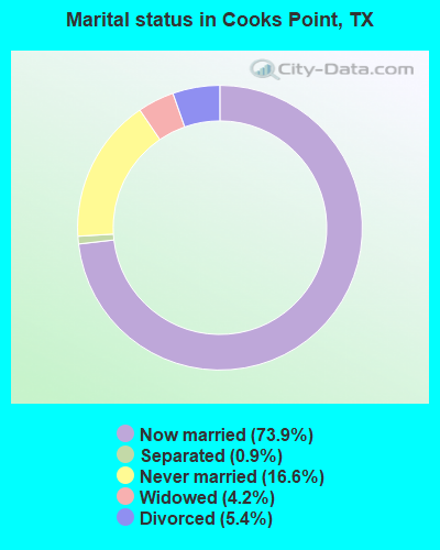
- Never married: 16.6%
- Now married: 73.9%
- Separated: 0.9%
- Widowed: 4.2%
- Divorced: 5.4%
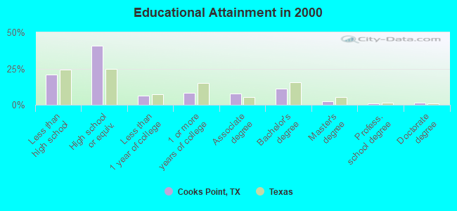
For population 25 years and over in Cooks Point:
- High school or higher: 79.2%
- Bachelor's degree or higher: 16.0%
- Graduate or professional degree: 4.9%
- Mean travel time to work (commute): 32.2 minutes
| Here: | 10.8 |
| Texas average: | 15.6 |
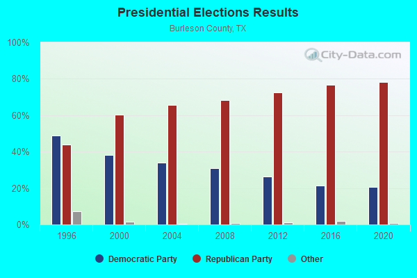
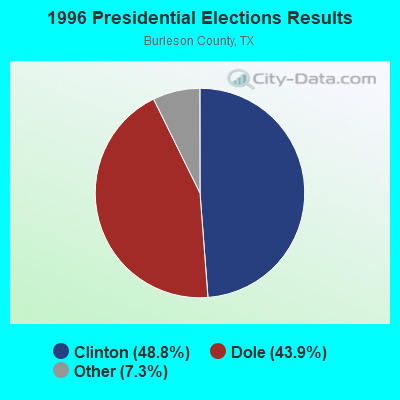
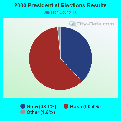
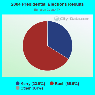

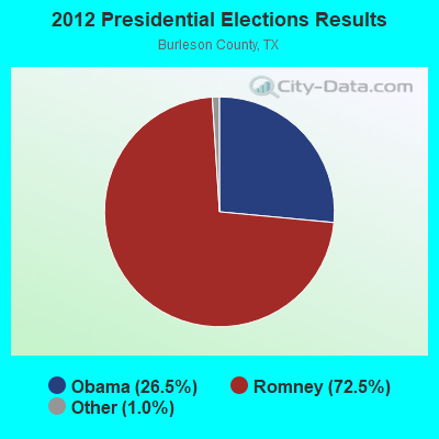
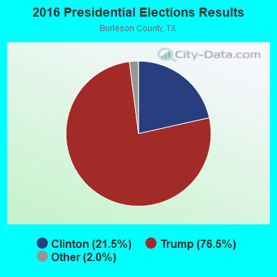
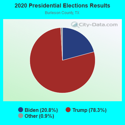
Graphs represent county-level data. Detailed 2008 Election Results
Religion statistics for Cooks Point, TX (based on Burleson County data)
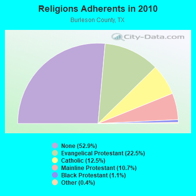
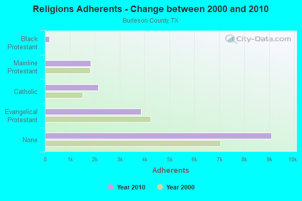
| Religion | Adherents | Congregations |
|---|---|---|
| Evangelical Protestant | 3,863 | 23 |
| Catholic | 2,144 | 3 |
| Mainline Protestant | 1,836 | 10 |
| Black Protestant | 183 | 1 |
| Other | 62 | 2 |
| None | 9,099 | - |
Food Environment Statistics:
| Burleson County: | 3.62 / 10,000 pop. |
| Texas: | 1.47 / 10,000 pop. |
| Burleson County: | 1.21 / 10,000 pop. |
| Texas: | 1.11 / 10,000 pop. |
| Here: | 7.85 / 10,000 pop. |
| Texas: | 3.95 / 10,000 pop. |
| Burleson County: | 9.06 / 10,000 pop. |
| Texas: | 6.13 / 10,000 pop. |
| Here: | 10.6% |
| Texas: | 8.9% |
| Burleson County: | 26.9% |
| Texas: | 26.6% |
| Burleson County: | 18.4% |
| State: | 15.7% |
Strongest AM radio stations in Cooks Point:
- KZNE (1150 AM; 10 kW; COLLEGE STATION, TX; Owner: BRYAN BROADCASTING LICENSE SUBSIDIARY, INC.)
- WTAW (1620 AM; 10 kW; COLLEGE STATION, TX; Owner: BRYAN BROADCASTING LICENSE SUBSIDIARY, INC.)
- KGOL (1180 AM; 50 kW; HUMBLE, TX; Owner: ENTRAVISION HOLDINGS, LLC)
- KTRH (740 AM; 50 kW; HOUSTON, TX; Owner: AMFM TEXAS LICENSES LIMITED PARTNERSHIP)
- KSEV (700 AM; 15 kW; TOMBALL, TX; Owner: LIBERMAN BROADCASTING OF HOUSTON LICENSE CORP.)
- KTKR (760 AM; 50 kW; SAN ANTONIO, TX; Owner: CCB TEXAS LICENSES, L.P.)
- WOAI (1200 AM; 50 kW; SAN ANTONIO, TX; Owner: CCB TEXAS LICENSES, L.P.)
- KKYX (680 AM; 50 kW; SAN ANTONIO, TX; Owner: CXR HOLDINGS, INC.)
- WBAP (820 AM; 50 kW; FORT WORTH, TX; Owner: WBAP-KSCS OPERATING, LTD.)
- KWBC (1550 AM; 5 kW; NAVASOTA, TX)
- KILE (1560 AM; 50 kW; BELLAIRE, TX; Owner: THE RAFTT CORPORATION)
- KJOJ (880 AM; 10 kW; CONROE, TX; Owner: LIBERMAN BROADCASTING OF HOUSTON LICENSE CORP.)
- KBBW (1010 AM; 10 kW; WACO-MARLIN, TX; Owner: AMERICAN BROADCASTING OF TEXAS)
Strongest FM radio stations in Cooks Point:
- KLTR (107.3 FM; CALDWELL, TX; Owner: ROY E. HENDERSON)
- KORA-FM (98.3 FM; BRYAN, TX; Owner: EQUICOM, INC)
- KNDE (95.1 FM; COLLEGE STATION, TX; Owner: BRYAN BROADCASTING LICENSE SUBSIDIARY, INC.)
- KTTX (106.1 FM; BRENHAM, TX; Owner: TOM S. WHITEHEAD, INC.)
- KXCS (103.9 FM; CAMERON, TX; Owner: EQUICOM, INC)
- KVJM (103.1 FM; HEARNE, TX; Owner: EQUAL ACCESS MEDIA, INC.)
- KAMU-FM (90.9 FM; COLLEGE STATION, TX; Owner: TEXAS A & M UNIVERSITY)
- KNFX-FM (99.5 FM; BRYAN, TX; Owner: CCB TEXAS LICENSES, L.P.)
- KEOS (89.1 FM; COLLEGE STATION, TX; Owner: BRAZOS EDUCATIONAL RADIO)
- K227AI (93.3 FM; COLLEGE STATION, TX; Owner: KSBJ EDUCATIONAL FOUNDATION)
- KKYS (104.7 FM; BRYAN, TX; Owner: CCB TEXAS LICENSES, L.P.)
- KMBV (92.5 FM; NAVASOTA, TX; Owner: FORT BEND BROADCASTING COMPANY)
- KULF (94.1 FM; BRENHAM, TX; Owner: FORT BEND BROADCASTING COMPANY)
- KAGG (96.1 FM; MADISONVILLE, TX; Owner: CCB TEXAS LICENSES, L.P.)
- K265DH (100.9 FM; BRYAN, TX; Owner: HOUSTON CHRISTIAN BROADCASTERS, INC.)
TV broadcast stations around Cooks Point:
- KYLE (Channel 28; BRYAN, TX; Owner: COMCORP OF BRYAN LICENSE CORP.)
- KBTX-TV (Channel 3; BRYAN, TX; Owner: KWTX-KBTX LICENSEE CORP.)
- KMAY-LP (Channel 23; BRYAN, TX; Owner: CHANNEL 6, INC.)
- K28AK (Channel 28; COLLEGE STATION, TX; Owner: CLEAR CHANNEL BROADCASTING LICENSES, INC.)
- KRHD-LP (Channel 34; BRYAN, TX; Owner: CENTEX TELEVISION LIMITED PARTNERSHIP)
- KSCM-LP (Channel 12; BRYAN, TX; Owner: R.D. HARRIS)
- KAMU-TV (Channel 15; COLLEGE STATION, TX; Owner: TEXAS A & M UNIVERSITY)
- K47ED (Channel 47; COLLEGE STATION, TX; Owner: TRINITY BROADCASTING NETWORK)
- KCEN-TV (Channel 6; TEMPLE, TX; Owner: CHANNEL 6, INC.)
Cooks Point fatal accident list:
FCC Registered Microwave Towers:
1- STATION, Railroad Milepost 24.0 Se Of (Lat: 30.586028 Lon: -96.599111), Overall height: 12.2 m, Call Sign: WEF856,
Assigned Frequencies: 2181.60 MHz, Grant Date: 08/03/1999, Expiration Date: 10/13/2009, Cancellation Date: 07/21/2008, Registrant: Union Pacific Railroad, 1400 Douglas St. Stop 0650, Omaha, NE 68179, Phone: (402) 544-1777, Fax: (402) 280-6565, Email:
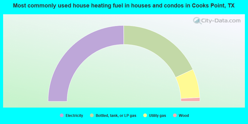
- 49.9%Electricity
- 36.3%Bottled, tank, or LP gas
- 12.2%Utility gas
- 1.6%Wood
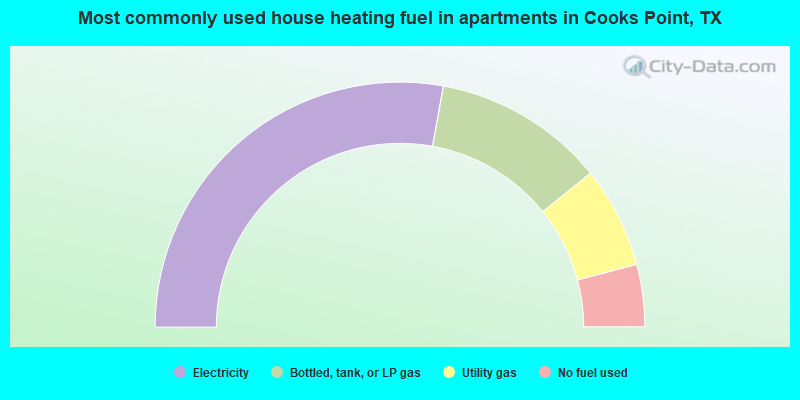
- 55.7%Electricity
- 22.7%Bottled, tank, or LP gas
- 13.4%Utility gas
- 8.2%No fuel used
Cooks Point compared to Texas state average:
- Unemployed percentage significantly below state average.
- Hispanic race population percentage significantly below state average.
- Median age significantly above state average.
- Foreign-born population percentage significantly below state average.
- Renting percentage significantly below state average.
- Length of stay since moving in significantly above state average.
- Number of rooms per house significantly below state average.
- House age significantly below state average.
- Number of college students significantly below state average.