Conway, Missouri
Submit your own pictures of this city and show them to the world
- OSM Map
- General Map
- Google Map
- MSN Map

Population change since 2000: -1.6%
 |
| Males: 371 | |
| Females: 360 |
| Median resident age: | 37.5 years |
| Missouri median age: | 39.1 years |
Zip codes: 65632.
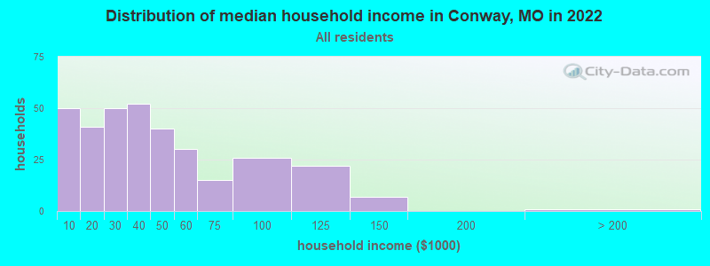
| Conway: | $31,503 |
| MO: | $64,811 |
Estimated per capita income in 2022: $18,476 (it was $11,623 in 2000)
Conway city income, earnings, and wages data
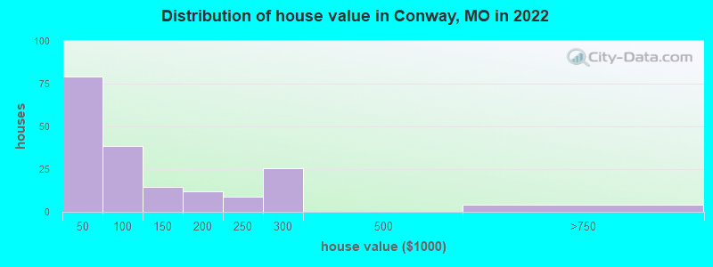
Estimated median house or condo value in 2022: $89,079 (it was $40,600 in 2000)
| Conway: | $89,079 |
| MO: | $221,200 |
Mean prices in 2022: all housing units: $131,447; detached houses: $131,454; mobile homes: $120,683
Median gross rent in 2022: $814.
(21.1% for White Non-Hispanic residents, 42.9% for two or more races residents)
Detailed information about poverty and poor residents in Conway, MO
Compare current foreclosures near Conway, MO:
| Photo | Address | Area | Beds / Baths | Price | Details |
|---|---|---|---|---|---|

|
#1
S Myrtle St
Conway, MO 65632
|
1,145 sq. feet
|
- baths 2 beds |
show details | |

|
#2
State Hwy 32
Buffalo, MO 65622
|
- sq. feet
|
2 baths 3 beds |
$69,900
|
show details |

|
#3
Slater Rd
Buffalo, MO 65622
|
1,008 sq. feet
|
1 baths 1 beds |
show details | |

|
#4
Sunrise Dr
Lebanon, MO 65536
|
1,282 sq. feet
|
1 baths 2 beds |
show details | |

|
#5
N Mill St
Marshfield, MO 65706
|
1,236 sq. feet
|
2 baths 3 beds |
show details | |

|
#6
N Adams Ave
Lebanon, MO 65536
|
- sq. feet
|
1 baths 3 beds |
show details | |

|
#7
Gulfwind Ln
Lebanon, MO 65536
|
1,338 sq. feet
|
- baths 3 beds |
show details | |

|
#8
Highway Aa
Lebanon, MO 65536
|
1,080 sq. feet
|
- baths 3 beds |
show details | |

|
#9
Lantern Ln
Lebanon, MO 65536
|
2,449 sq. feet
|
- baths 3 beds |
show details | |

|
#10
Indian Creek Dr
Lebanon, MO 65536
|
1,624 sq. feet
|
- baths 3 beds |
show details |
| Photo | Address | Area | Beds / Baths | Price | Details |
|---|---|---|---|---|---|

|
#11
Gresham Ln
Lebanon, MO 65536
|
864 sq. feet
|
- baths 2 beds |
show details | |

|
#12
King James Rd
Lebanon, MO 65536
|
1,653 sq. feet
|
- baths 3 beds |
show details | |

|
#13
Maine Dr
Lebanon, MO 65536
|
798 sq. feet
|
- baths 3 beds |
show details | |

|
#14
Highway 64
Lebanon, MO 65536
|
1,062 sq. feet
|
- baths 3 beds |
show details | |

|
#15
Missouri Dr
Lebanon, MO 65536
|
1,500 sq. feet
|
- baths 3 beds |
show details | |

|
#16
Cross Creek Rd
Marshfield, MO 65706
|
- sq. feet
|
- baths - beds |
show details | |

|
#17
Belwood Rd
Lebanon, MO 65536
|
- sq. feet
|
- baths - beds |
show details | |

|
#18
Oak St
Lebanon, MO 65536
|
- sq. feet
|
- baths - beds |
show details | |

|
#19
Herndon Rd
Lebanon, MO 65536
|
- sq. feet
|
- baths - beds |
show details | |

|
#20
Millcreek Rd
Lebanon, MO 65536
|
- sq. feet
|
- baths - beds |
show details |
| Photo | Address | Area | Beds / Baths | Price | Details |
|---|---|---|---|---|---|

|
#21
Harwood Ave
Lebanon, MO 65536
|
- sq. feet
|
- baths - beds |
show details | |

|
#22
Catalpa Ln
Lebanon, MO 65536
|
- sq. feet
|
- baths - beds |
show details | |

|
#23
Babb Dr
Lebanon, MO 65536
|
- sq. feet
|
- baths - beds |
show details | |

|
#24
Park Dr
Lebanon, MO 65536
|
- sq. feet
|
- baths - beds |
show details | |

|
#25
Chrystle Dr
Lebanon, MO 65536
|
- sq. feet
|
- baths - beds |
show details | |

|
#26
Highway 64
Lebanon, MO 65536
|
- sq. feet
|
- baths - beds |
show details | |

|
#27
Chicago Rd
Elkland, MO 65644
|
- sq. feet
|
- baths - beds |
show details | |

|
#28
State Highway Cc
Niangua, MO 65713
|
- sq. feet
|
- baths - beds |
show details | |

|
#29
E Mcvay St
Marshfield, MO 65706
|
- sq. feet
|
- baths - beds |
show details | |

|
#30
Nickel Dr
Phillipsburg, MO 65722
|
- sq. feet
|
- baths - beds |
show details |
| Photo | Address | Area | Beds / Baths | Price | Details |
|---|---|---|---|---|---|

|
#31
State Road K
Long Lane, MO 65590
|
- sq. feet
|
- baths - beds |
show details | |

|
#32
Briarwood Dr
Marshfield, MO 65706
|
- sq. feet
|
- baths - beds |
show details | |

|
#33
N White Oak Rd
Marshfield, MO 65706
|
- sq. feet
|
- baths - beds |
show details | |

|
#34
Banning St Apt D4
Marshfield, MO 65706
|
- sq. feet
|
- baths - beds |
show details | |

|
#35
Elkland Rd
Elkland, MO 65644
|
- sq. feet
|
- baths - beds |
show details | |

|
#36
E 2nd St
Marshfield, MO 65706
|
- sq. feet
|
- baths - beds |
show details | |

|
#37
State Highway 38
Marshfield, MO 65706
|
- sq. feet
|
- baths - beds |
show details | |

|
#38
E Mcvay St
Marshfield, MO 65706
|
- sq. feet
|
- baths - beds |
show details | |

|
#39
State Highway 38
Elkland, MO 65644
|
- sq. feet
|
- baths - beds |
show details | |

|
#40
Hillview Dr
Marshfield, MO 65706
|
- sq. feet
|
- baths - beds |
show details |
| Photo | Address | Area | Beds / Baths | Price | Details |
|---|---|---|---|---|---|

|
#41
S White Oak Rd
Marshfield, MO 65706
|
- sq. feet
|
- baths - beds |
show details | |

|
#42
Britney Dr
Lebanon, MO 65536
|
- sq. feet
|
- baths - beds |
show details | |

|
#43
Neosho Dr
Lebanon, MO 65536
|
- sq. feet
|
- baths - beds |
show details | |

|
#44
Ostrich Ln
Lebanon, MO 65536
|
- sq. feet
|
- baths - beds |
show details | |

|
#45
E Main St
Buffalo, MO 65622
|
- sq. feet
|
- baths - beds |
show details | |

|
#46
State Highway Oo
Marshfield, MO 65706
|
- sq. feet
|
- baths - beds |
show details | |

|
#47
Sunshine St
Marshfield, MO 65706
|
- sq. feet
|
- baths - beds |
show details | |

|
#48
Equestrian Rd
Lebanon, MO 65536
|
- sq. feet
|
- baths - beds |
show details | |

|
#49
Country Club Dr
Marshfield, MO 65706
|
- sq. feet
|
- baths - beds |
show details | |

|
Check over 1 million property listings on Foreclosure.com!
|
browse all offers | |||


- 70196.8%White alone
- 91.2%Two or more races
- 60.8%Black alone
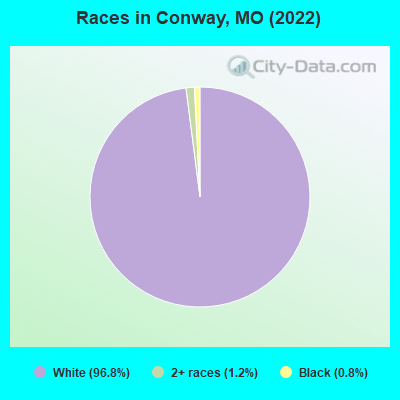
Races in Conway detailed stats: ancestries, foreign born residents, place of birth
According to our research of Missouri and other state lists, there were 15 registered sex offenders living in Conway, Missouri as of May 17, 2024.
The ratio of all residents to sex offenders in Conway is 63 to 1.
 Recent articles from our blog. Our writers, many of them Ph.D. graduates or candidates, create easy-to-read articles on a wide variety of topics.

 | Missouri Outlaw History (3407 replies) |
| Definitions of Mid, South, North, and West St. Louis County? (42 replies) |
| Long ago on independence square (13162 replies) |
| Interesting Missouri facts. (1186 replies) |
| From Chicago to St. Louis? (27 replies) |
| Ladue vs Rockwood schools (12 replies) |
Latest news from Conway, MO collected exclusively by city-data.com from local newspapers, TV, and radio stations
Ancestries: English (42.1%), American (23.1%), Irish (10.0%), Swedish (3.7%), German (1.0%), Norwegian (1.0%).
Current Local Time: CST time zone
Incorporated in 1927
Elevation: 1405 feet
Land area: 1.82 square miles.
Population density: 401 people per square mile (low).
Median real estate property taxes paid for housing units with mortgages in 2022: $510 (0.5%)
Median real estate property taxes paid for housing units with no mortgage in 2022: $337 (0.8%)
Nearest city with pop. 50,000+: Springfield, MO  (33.0 miles , pop. 151,580).
Nearest city with pop. 200,000+: Kansas City, MO (143.9 miles , pop. 441,545).
Nearest city with pop. 1,000,000+: Dallas, TX (394.8 miles , pop. 1,188,580).
Nearest cities:
), )Latitude: 37.50 N, Longitude: 92.82 W
Area code: 417

| Here: | 3.4% |
| Missouri: | 2.8% |
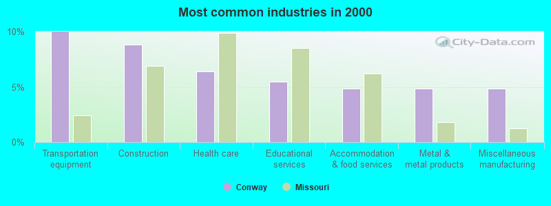
- Transportation equipment (10.0%)
- Construction (8.8%)
- Health care (6.4%)
- Educational services (5.5%)
- Accommodation & food services (4.9%)
- Metal & metal products (4.9%)
- Miscellaneous manufacturing (4.9%)
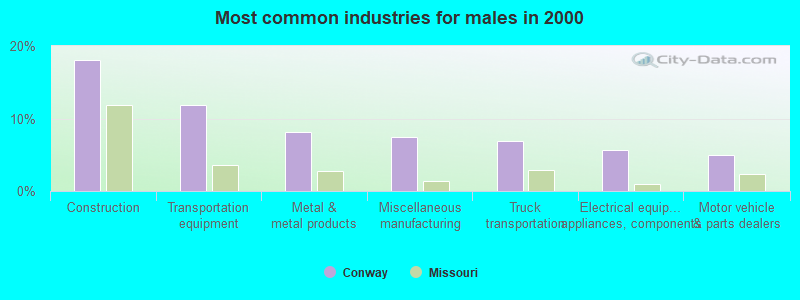
- Construction (18.1%)
- Transportation equipment (11.9%)
- Metal & metal products (8.1%)
- Miscellaneous manufacturing (7.5%)
- Truck transportation (6.9%)
- Electrical equipment, appliances, components (5.6%)
- Motor vehicle & parts dealers (5.0%)
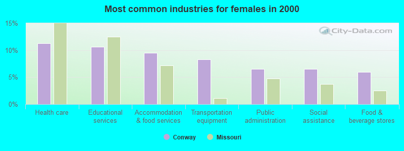
- Health care (11.2%)
- Educational services (10.7%)
- Accommodation & food services (9.5%)
- Transportation equipment (8.3%)
- Public administration (6.5%)
- Social assistance (6.5%)
- Food & beverage stores (5.9%)
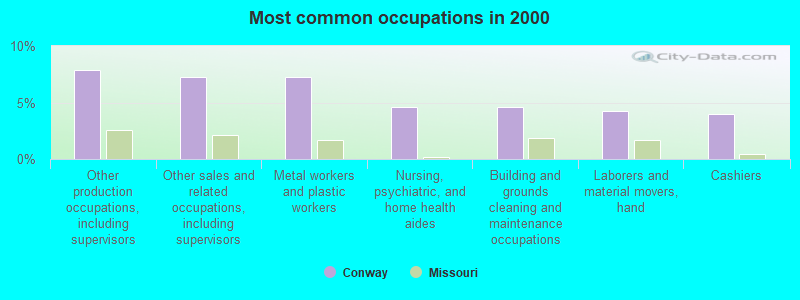
- Other production occupations, including supervisors (7.9%)
- Other sales and related occupations, including supervisors (7.3%)
- Metal workers and plastic workers (7.3%)
- Nursing, psychiatric, and home health aides (4.6%)
- Building and grounds cleaning and maintenance occupations (4.6%)
- Laborers and material movers, hand (4.3%)
- Cashiers (4.0%)
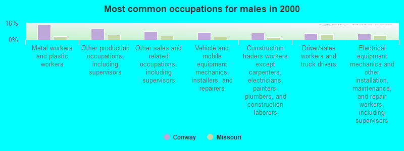
- Metal workers and plastic workers (14.4%)
- Other production occupations, including supervisors (11.2%)
- Other sales and related occupations, including supervisors (8.1%)
- Vehicle and mobile equipment mechanics, installers, and repairers (7.5%)
- Construction traders workers except carpenters, electricians, painters, plumbers, and construction laborers (6.9%)
- Driver/sales workers and truck drivers (6.2%)
- Electrical equipment mechanics and other installation, maintenance, and repair workers, including supervisors (5.6%)
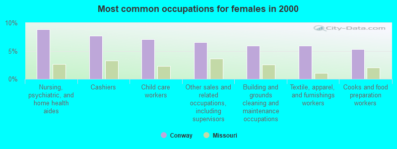
- Nursing, psychiatric, and home health aides (8.9%)
- Cashiers (7.7%)
- Child care workers (7.1%)
- Other sales and related occupations, including supervisors (6.5%)
- Building and grounds cleaning and maintenance occupations (5.9%)
- Textile, apparel, and furnishings workers (5.9%)
- Cooks and food preparation workers (5.3%)
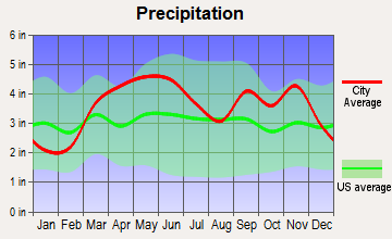
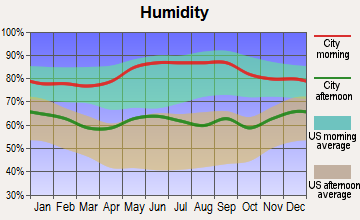
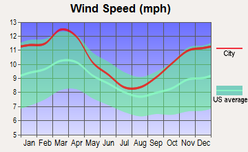
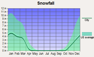
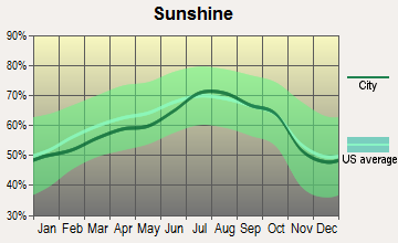
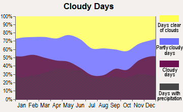
Average climate in Conway, Missouri
Based on data reported by over 4,000 weather stations

Tornado activity:
Conway-area historical tornado activity is slightly below Missouri state average. It is 25% greater than the overall U.S. average.
On 9/26/1959, a category F4 (max. wind speeds 207-260 mph) tornado 13.4 miles away from the Conway city center caused between $50,000 and $500,000 in damages.
On 11/29/1991, a category F4 tornado 30.1 miles away from the city center killed 2 people and injured 64 people and caused between $5,000,000 and $50,000,000 in damages.
Earthquake activity:
Conway-area historical earthquake activity is significantly above Missouri state average. It is 513% greater than the overall U.S. average.On 9/3/2016 at 12:02:44, a magnitude 5.8 (5.8 MW, Depth: 3.5 mi, Class: Moderate, Intensity: VI - VII) earthquake occurred 238.7 miles away from Conway center
On 11/6/2011 at 03:53:10, a magnitude 5.7 (5.7 MW, Depth: 3.2 mi) earthquake occurred 257.9 miles away from Conway center
On 5/4/1991 at 01:18:54, a magnitude 5.0 (4.4 MB, 4.6 LG, 5.0 LG, Depth: 3.1 mi) earthquake occurred 177.9 miles away from Conway center
On 9/26/1990 at 13:18:51, a magnitude 5.0 (4.7 MB, 4.8 LG, 5.0 LG, Depth: 7.7 mi) earthquake occurred 182.4 miles away from Conway center
On 3/25/1976 at 00:41:20, a magnitude 5.0 (4.9 MB, 5.0 LG) earthquake occurred 189.4 miles away from Conway center
On 4/18/2008 at 09:36:59, a magnitude 5.4 (5.1 MB, 4.8 MS, 5.4 MW, 5.2 MW) earthquake occurred 277.1 miles away from the city center
Magnitude types: regional Lg-wave magnitude (LG), body-wave magnitude (MB), surface-wave magnitude (MS), moment magnitude (MW)
Natural disasters:
The number of natural disasters in Laclede County (22) is greater than the US average (15).Major Disasters (Presidential) Declared: 14
Emergencies Declared: 6
Causes of natural disasters: Floods: 14, Storms: 13, Tornadoes: 10, Winds: 5, Winter Storms: 5, Drought: 1, Heavy Rain: 1, Hurricane: 1, Snowstorm: 1, Other: 1 (Note: some incidents may be assigned to more than one category).

Hospitals and medical centers near Conway:
- MARSHFIELD CARE CENTER (Nursing Home, about 13 miles away; MARSHFIELD, MO)
- CHRISTIAN HEALTH AND REHAB OF LEBANON SOUTH (Nursing Home, about 14 miles away; LEBANON, MO)
- WEBCO MANOR (Nursing Home, about 14 miles away; MARSHFIELD, MO)
- CHRISTIAN HEALTH AND REHABILITATION OF LEBANON NORTH (Nursing Home, about 15 miles away; LEBANON, MO)
- BREECH MEDICAL CENTER (Nursing Home, about 16 miles away; LEBANON, MO)
Colleges/universities with over 2000 students nearest to Conway:
- Evangel University (about 31 miles; Springfield, MO; Full-time enrollment: 2,036)
- Ozarks Technical Community College (about 32 miles; Springfield, MO; FT enrollment: 10,356)
- Drury University (about 32 miles; Springfield, MO; FT enrollment: 3,902)
- Missouri State University-Springfield (about 33 miles; Springfield, MO; FT enrollment: 16,660)
- Southwest Baptist University (about 33 miles; Bolivar, MO; FT enrollment: 2,783)
- Missouri University of Science and Technology (about 66 miles; Rolla, MO; FT enrollment: 6,486)
- Lincoln University (about 82 miles; Jefferson City, MO; FT enrollment: 2,348)
Public high school in Conway:
- CONWAY HIGH (Students: 238, Location: 726 W JEFFERSON AVE, Grades: 9-12)
Public elementary/middle schools in Conway:
- EZARD ELEM. (Students: 627, Location: 209 S SHILOH AVE, Grades: PK-6)
- CONWAY JR. HIGH (Students: 147, Location: 726 W JEFFERSON AVE, Grades: 7-8)
Points of interest:
Notable location: Conway Volunteer Fire Department (A). Display/hide its location on the map
Church in Conway: Conway Freewill Baptist Church (A). Display/hide its location on the map
Cemetery: Conway Cemetery (1). Display/hide its location on the map
Hotel: Budget Inn (101 Martingale Drive).
Drinking water stations with addresses in Conway and their reported violations in the past:
CONWAY (Population served: 788, Groundwater):Past health violations:SORRELLS TRADING POST (Population served: 25, Groundwater):Past monitoring violations:
- MCL, Monthly (TCR) - In OCT-2013, Contaminant: Coliform. Follow-up actions: St Formal NOV issued (OCT-24-2013), St Public Notif requested (OCT-24-2013), St Public Notif received (DEC-09-2013), St Compliance achieved (JAN-22-2014)
- MCL, Monthly (TCR) - In SEP-2008, Contaminant: Coliform. Follow-up actions: St Public Notif requested (SEP-23-2008), St Violation/Reminder Notice (SEP-23-2008), St Public Notif received (NOV-17-2008), St Compliance achieved (JAN-22-2014)
- MCL, Monthly (TCR) - In AUG-2008, Contaminant: Coliform. Follow-up actions: St Public Notif requested (AUG-26-2008), St Violation/Reminder Notice (AUG-26-2008), St Public Notif received (OCT-09-2008), St Compliance achieved (JAN-22-2014)
- MCL, Monthly (TCR) - In JUL-2008, Contaminant: Coliform. Follow-up actions: St Public Notif requested (AUG-05-2008), St Violation/Reminder Notice (AUG-05-2008), St Public Notif received (AUG-25-2008), St Compliance achieved (JAN-22-2014)
- MCL, Monthly (TCR) - In JUL-2007, Contaminant: Coliform. Follow-up actions: St Public Notif requested (AUG-24-2007), St Violation/Reminder Notice (AUG-24-2007), St Public Notif received (OCT-05-2007), St Compliance achieved (JAN-22-2014)
- One minor monitoring violation
Past health violations:Past monitoring violations:
- MCL, Monthly (TCR) - In FEB-2005, Contaminant: Coliform. Follow-up actions: St Public Notif requested (MAR-03-2005), St Violation/Reminder Notice (MAR-03-2005), St Compliance achieved (JAN-22-2014)
- Monitoring, Source Water (GWR) - In FEB-01-2014, Contaminant: E. COLI. Follow-up actions: St Public Notif requested (FEB-24-2014), St Violation/Reminder Notice (2 times from FEB-24-2014 to MAR-27-2014), St Formal NOV issued (JUN-10-2014)
- Monitoring, Repeat Major (TCR) - In JAN-2014, Contaminant: Coliform (TCR). Follow-up actions: St Public Notif requested (MAR-04-2014), St Violation/Reminder Notice (2 times from MAR-04-2014 to MAR-27-2014), St Formal NOV issued (JUN-10-2014)
- 9 routine major monitoring violations
- One regular monitoring violation
| This city: | 2.6 people |
| Missouri: | 2.5 people |
| This city: | 70.3% |
| Whole state: | 65.3% |
| This city: | 8.9% |
| Whole state: | 6.7% |
Likely homosexual households (counted as self-reported same-sex unmarried-partner households)
- Lesbian couples: 0.3% of all households
- Gay men: 0.0% of all households
Banks with branches in Conway (2011 data):
- Central Bank: Conway Facility at State Highways Y And Cc, branch established on 1978/08/07. Info updated 2006/11/03: Bank assets: $240.9 mil, Deposits: $201.2 mil, headquarters in Lebanon, MO, positive income, Commercial Lending Specialization, 5 total offices, Holding Company: Central Missouri Shares, Inc.
For population 15 years and over in Conway:
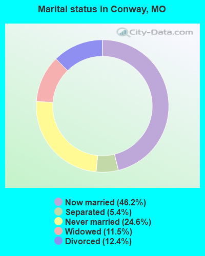
- Never married: 24.6%
- Now married: 46.2%
- Separated: 5.4%
- Widowed: 11.5%
- Divorced: 12.4%
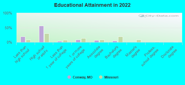
For population 25 years and over in Conway:
- High school or higher: 79.8%
- Bachelor's degree or higher: 5.4%
- Graduate or professional degree: 0.8%
- Unemployed: 4.4%
- Mean travel time to work (commute): 31.1 minutes
| Here: | 8.0 |
| Missouri average: | 11.1 |
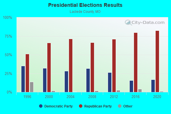
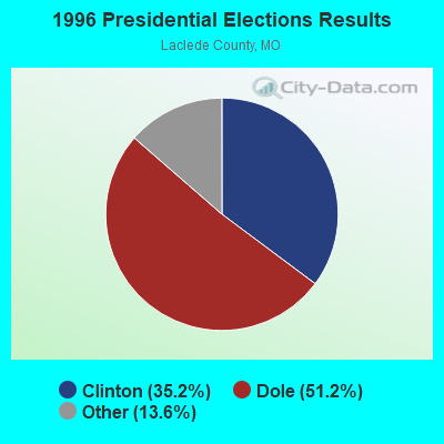
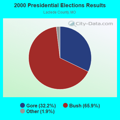

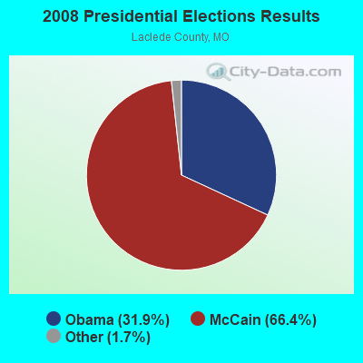
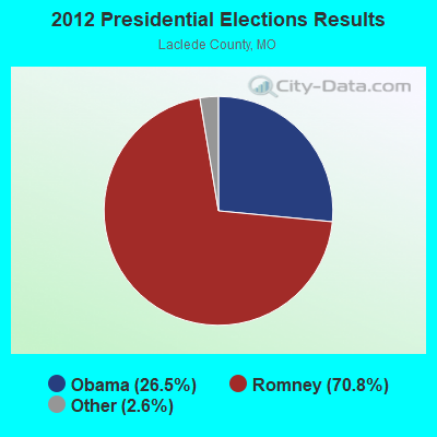
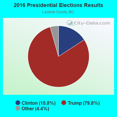
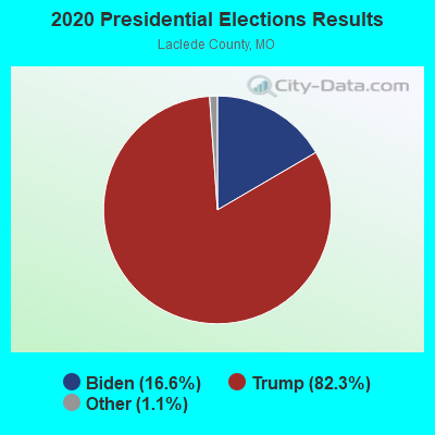
Graphs represent county-level data. Detailed 2008 Election Results
Religion statistics for Conway, MO (based on Laclede County data)
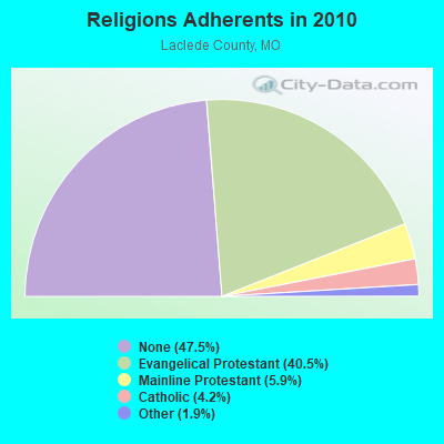
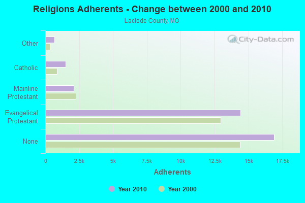
| Religion | Adherents | Congregations |
|---|---|---|
| Evangelical Protestant | 14,411 | 67 |
| Mainline Protestant | 2,090 | 13 |
| Catholic | 1,488 | 2 |
| Other | 677 | 3 |
| None | 16,905 | - |
Food Environment Statistics:
| Laclede County: | 3.11 / 10,000 pop. |
| Missouri: | 1.88 / 10,000 pop. |
| This county: | 0.28 / 10,000 pop. |
| Missouri: | 0.18 / 10,000 pop. |
| Laclede County: | 7.64 / 10,000 pop. |
| State: | 4.34 / 10,000 pop. |
| This county: | 7.36 / 10,000 pop. |
| State: | 7.37 / 10,000 pop. |
| Laclede County: | 8.6% |
| Missouri: | 8.8% |
| Here: | 29.3% |
| Missouri: | 29.6% |
| Here: | 14.4% |
| Missouri: | 13.5% |
Health and Nutrition:
| Conway: | 46.4% |
| State: | 50.9% |
| Here: | 46.3% |
| State: | 48.6% |
| Here: | 28.0 |
| Missouri: | 28.7 |
| This city: | 14.9% |
| Missouri: | 20.6% |
| Conway: | 9.4% |
| State: | 10.1% |
| Conway: | 6.9 |
| Missouri: | 6.8 |
| Conway: | 27.6% |
| Missouri: | 34.3% |
| Here: | 56.7% |
| Missouri: | 57.5% |
| This city: | 83.6% |
| State: | 79.3% |
More about Health and Nutrition of Conway, MO Residents
| Local government employment and payroll (March 2022) | |||||
| Function | Full-time employees | Monthly full-time payroll | Average yearly full-time wage | Part-time employees | Monthly part-time payroll |
|---|---|---|---|---|---|
| Water Supply | 2 | $6,320 | $37,920 | 1 | $1,256 |
| Other Government Administration | 1 | $3,280 | $39,360 | 0 | $0 |
| Police Protection - Officers | 1 | $3,082 | $36,984 | 5 | $1,914 |
| Totals for Government | 4 | $12,682 | $38,046 | 6 | $3,170 |
Conway government finances - Expenditure in 2017 (per resident):
- Current Operations - Police Protection: $105,000 ($143.64)
Regular Highways: $99,000 ($135.43)
Central Staff Services: $86,000 ($117.65)
Sewerage: $83,000 ($113.54)
Water Utilities: $74,000 ($101.23)
Parks and Recreation: $1,000 ($1.37)
- Total Salaries and Wages: $124,000 ($169.63)
- Water Utilities - Interest on Debt: $15,000 ($20.52)
Conway government finances - Revenue in 2017 (per resident):
- Charges - Sewerage: $94,000 ($128.59)
- Miscellaneous - Fines and Forfeits: $77,000 ($105.34)
General Revenue - Other: $13,000 ($17.78)
Interest Earnings: $11,000 ($15.05)
- Revenue - Water Utilities: $87,000 ($119.02)
- State Intergovernmental - Highways: $21,000 ($28.73)
Other: $13,000 ($17.78)
- Tax - General Sales and Gross Receipts: $163,000 ($222.98)
Occupation and Business License - Other: $35,000 ($47.88)
Motor Vehicle License: $9,000 ($12.31)
Public Utilities Sales: $2,000 ($2.74)
Other License: $1,000 ($1.37)
Conway government finances - Debt in 2017 (per resident):
- Long Term Debt - Beginning Outstanding - Unspecified Public Purpose: $255,000 ($348.84)
Outstanding Unspecified Public Purpose: $210,000 ($287.28)
Retired Unspecified Public Purpose: $45,000 ($61.56)
Conway government finances - Cash and Securities in 2017 (per resident):
- Other Funds - Cash and Securities: $133,000 ($181.94)
- Sinking Funds - Cash and Securities: $242,000 ($331.05)
Strongest AM radio stations in Conway:
- KBNN (750 AM; daytime; 5 kW; LEBANON, MO; Owner: OZARK BROADCASTING, INC.)
- KMRF (1510 AM; daytime; 5 kW; MARSHFIELD, MO; Owner: NEW LIFE EVANGELISTIC CENTER, INC.)
- KRMS (1150 AM; 10 kW; OSAGE BEACH, MO; Owner: VIPER COMMUNICATIONS, INC)
- KWTO (560 AM; 5 kW; SPRINGFIELD, MO; Owner: KWTO, INC.)
- KSGF (1260 AM; 5 kW; SPRINGFIELD, MO; Owner: JOURNAL BROADCAST CORPORATION)
- KLWT (1230 AM; 1 kW; LEBANON, MO; Owner: PEARSON BROADCASTING OF LEBANON, INC.)
- KLFJ (1550 AM; 5 kW; SPRINGFIELD, MO; Owner: 127, INC.)
- WHB (810 AM; 50 kW; KANSAS CITY, MO; Owner: UNION BROADCASTING, INC.)
- KJPW (1390 AM; 5 kW; WAYNESVILLE, MO; Owner: PULASKI COUNTY BROADCASTERS, INC.)
- KXEN (1010 AM; 50 kW; FESTUS-ST. LOUIS, MO; Owner: BDJ RADIO ENTERPRISES, LLC)
- KMOX (1120 AM; 50 kW; ST. LOUIS, MO; Owner: INFINITY BROADCASTING OPERATIONS, INC.)
- KGHT (880 AM; 50 kW; SHERIDAN, AR; Owner: METROPOLITAN RADIO GROUP, INC.)
- KRMG (740 AM; 50 kW; TULSA, OK; Owner: CXR HOLDINGS, INC.)
Strongest FM radio stations in Conway:
- KJEL (103.7 FM; LEBANON, MO; Owner: OZARK BROADCASTING, INC.)
- KTXR (101.3 FM; SPRINGFIELD, MO; Owner: STEREO BROADCASTING, INC.)
- KWFC (89.1 FM; SPRINGFIELD, MO; Owner: BAPTIST BIBLE COLLEGE, INC.)
- KXUS (97.3 FM; SPRINGFIELD, MO; Owner: CLEAR CHANNEL BROADCASTING LICENSES, INC.)
- KTTK (90.7 FM; LEBANON, MO; Owner: LEBANON EDUCATIONAL BROADCASTING FOUNDATION)
- KBFL (99.9 FM; BUFFALO, MO; Owner: MEYER-BALDRIDGE, INC.)
- KTTS-FM (94.7 FM; SPRINGFIELD, MO; Owner: JOURNAL BROADCAST CORPORATION)
- KKLH (104.7 FM; MARSHFIELD, MO; Owner: MW SPRINGMO, INC.)
- KCLQ (107.9 FM; LEBANON, MO; Owner: PEARSON BROADCASTING OF LEBANON, INC.)
- KGBX-FM (105.9 FM; NIXA, MO; Owner: CLEAR CHANNEL BROADCASTING LICENSES, INC.)
- KSCV (90.1 FM; SPRINGFIELD, MO; Owner: COMMUNITY BROADCASTING, INC.)
- KTOZ-FM (95.5 FM; PLEASANT HOPE, MO; Owner: CLEAR CHANNEL BROADCASTING LICENSES, INC.)
- KNLM (91.9 FM; MARSHFIELD, MO; Owner: NEW LIFE EVANGELISTIC CENTER, INC.)
- K242AN (96.3 FM; LEBANON, MO; Owner: CURATORS OF THE UNIV. OF MISSOURI)
- KWND (88.3 FM; SPRINGFIELD, MO; Owner: RADIO TRAINING NETWORK, INC)
TV broadcast stations around Conway:
- KYTV (Channel 3; SPRINGFIELD, MO; Owner: KY3, INC.)
- KSPR (Channel 33; SPRINGFIELD, MO; Owner: PIEDMONT TELEVISION OF SPRINGFIELD LICENSE LLC)
- KOLR (Channel 10; SPRINGFIELD, MO; Owner: VHR SPRINGFIELD LICENSE, INC.)
- KDEB-TV (Channel 27; SPRINGFIELD, MO; Owner: QUORUM OF MISSOURI LICENSE, LLC)
- KOZK (Channel 21; SPRINGFIELD, MO; Owner: BD. OF GOVERNORS OF SW MISSOURI STATE UNIVERSITY)
- KWBS-LP (Channel 56; SPRINGFIELD, MO; Owner: EQUITY BROADCASTING CORPORATION)
- K68EL (Channel 68; MARSHFIELD, MO; Owner: NEW LIFE EVANGELISTIC CENTER, INC.)
- K64FQ (Channel 64; LEBANON, MO; Owner: NEW LIFE EVANGELISTIC CENTER, INC.)
- K41FQ (Channel 41; SPRINGFIELD, MO; Owner: TRINITY BROADCASTING NETWORK)
- K15CZ (Channel 15; SPRINGFIELD, MO; Owner: KY3, INC.)
Conway fatal accident list:
Feb 8, 2015 12:42 AM, Sr-J, Sr-Cc, Lat: 37.502583, Lon: -92.825806, Vehicles: 6, Persons: 3, Fatalities: 1
Aug 23, 1998 02:35 PM, Southmyrtle, Vehicles: 1, Persons: 2, Fatalities: 1
- National Bridge Inventory (NBI) Statistics
- 20Number of bridges
- 59ft / 17.5mTotal length
- $186,000Total costs
- 95,604Total average daily traffic
- 26,926Total average daily truck traffic
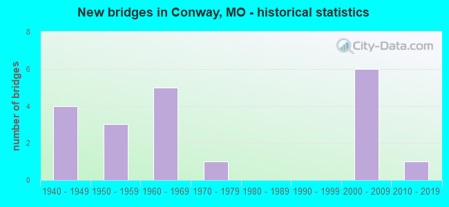
- New bridges - historical statistics
- 41940-1949
- 31950-1959
- 51960-1969
- 11970-1979
- 62000-2009
- 12010-2019
FCC Registered Antenna Towers:
37 (See the full list of FCC Registered Antenna Towers in Conway)FCC Registered Broadcast Land Mobile Towers:
1- Lat: 37.501556 Lon: -92.836222, Call Sign: WPXA877,
Assigned Frequencies: 451.450 MHz, Grant Date: 11/29/2022, Expiration Date: 02/24/2033, Certifier: Diana J Stacks, Registrant: Mark Steele Communications, 5620 S Mccann Ave, Springfield, MO 65804, Phone: (417) 882-0119, Email:
FCC Registered Microwave Towers:
3- CONWAY, 1460 Dallas Coutny Line Road (Lat: 37.482861 Lon: -92.857167), Type: Tower, Structure height: 100.5 m, Overall height: 106.3 m, Call Sign: WQJY663,
Assigned Frequencies: 6034.15 MHz, 5945.20 MHz, Grant Date: 02/18/2009, Expiration Date: 02/18/2019, Cancellation Date: 06/02/2010, Certifier: James E Mcdonald, Registrant: Alltel Communications, LLC, One Allied Drive, B1f02-D, Little Rock, AR 72202, Phone: (501) 905-8555, Fax: (501) 905-6193, Email:
- A5S0030B, 662 Blazing Star Road (Lat: 37.475389 Lon: -92.854583), Type: Gtower, Structure height: 60.7 m, Call Sign: WQWC928,
Assigned Frequencies: 11265.0 MHz, 11265.0 MHz, 11265.0 MHz, 11265.0 MHz, 11265.0 MHz, 11265.0 MHz, 11265.0 MHz, 11265.0 MHz, Grant Date: 07/21/2015, Expiration Date: 07/21/2025, Cancellation Date: 11/25/2022, Certifier: David Werblow, Registrant: T-Mobile Usa, Inc., 12920 Se 38th Street, Bellevue, WA 98006, Phone: (425) 383-8401, Fax: (425) 383-4040, Email:
- CONWAY, Laclede Co. Hwy. Y, 1 Mile E. Of (Lat: 37.505889 Lon: -92.804056), Type: Tower, Structure height: 29 m, Call Sign: WEF380,
Assigned Frequencies: 953.300 MHz, Grant Date: 09/24/1998, Expiration Date: 12/16/2008, Cancellation Date: 05/02/2001, Registrant: Keller And Heckman LLP, 1001 G Street, Nw, Suite 500 West, Washington, DC 20001, Phone: (202) 434-4230, Fax: (202) 434-4646, Email:
FCC Registered Amateur Radio Licenses:
16 (See the full list of FCC Registered Amateur Radio Licenses in Conway)FAA Registered Aircraft:
5- Aircraft: CESSNA 150 (Category: Land, Seats: 2, Weight: Up to 12,499 Pounds, Speed: 90 mph), Engine: CONT MOTOR 0-200-A (100 HP) (Reciprocating)
N-Number: 5666E, N5666E, N-5666E, Serial Number: 17166, Year manufactured: 1959, Airworthiness Date: 07/14/2006, Certificate Issue Date: 03/08/2016
Registrant (Individual): Nick Gann, 13500 Highway Pp, Conway, MO 65632 - Aircraft: LUSCOMBE 8A (Category: Land, Seats: 2, Weight: Up to 12,499 Pounds, Speed: 86 mph), Engine: CONT MOTOR A&C65 SERIES (65 HP) (Reciprocating)
N-Number: 71923, N71923, N-71923, Serial Number: 3350, Year manufactured: 1946, Airworthiness Date: 11/23/1955, Certificate Issue Date: 01/21/1992
Registrant (Individual): Nick Gann, 13500 Highway Pp, Conway, MO 65632 - Aircraft: PIPER PA-28-180 (Category: Land, Seats: 4, Weight: Up to 12,499 Pounds, Speed: 107 mph), Engine: LYCOMING O&VO-360 SER (180 HP) (Reciprocating)
N-Number: 7479W, N7479W, N-7479W, Serial Number: 28-1389, Year manufactured: 1963, Airworthiness Date: 07/24/1963, Certificate Issue Date: 04/14/2009
Registrant (Co-Owned): Tom R Walsh, 50 Raspberry Ln, Conway, MO 65632, Other Owners: Sandra K Walsh - Aircraft: CESSNA 150H (Category: Land, Seats: 2, Weight: Up to 12,499 Pounds, Speed: 90 mph), Engine: Reciprocating
N-Number: 830JD, N830JD, N-830JD, Serial Number: 15068819, Certificate Issue Date: 01/23/2004
Registrant (Partnership): David D Marlin, 322 Marlin Prairie Dr, Conway, MO 65632, Other Owners: Robin P Marlin - Aircraft: CESSNA 180J (Category: Land, Seats: 6, Weight: Up to 12,499 Pounds, Speed: 120 mph), Engine: CONT MOTOR O-470 SERIES (230 HP) (Reciprocating)
N-Number: 9921N, N9921N, N-9921N, Serial Number: 18052576, Year manufactured: 1975, Airworthiness Date: 03/21/1975, Certificate Issue Date: 07/12/2011
Registrant (Co-Owned): Terry Lee Cossey, 10400 Aspen Rd, Conway, MO 65632, Other Owners: Downing Teresa Cossey
2003 - 2018 National Fire Incident Reporting System (NFIRS) incidents
- Fire incident types reported to NFIRS in Conway, MO
- 7144.7%Structure Fires
- 6742.1%Outside Fires
- 1610.1%Mobile Property/Vehicle Fires
- 53.1%Other
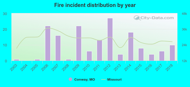 Based on the data from the years 2003 - 2018 the average number of fire incidents per year is 10. The highest number of reported fire incidents - 27 took place in 2012, and the least - 0 in 2004. The data has a rising trend.
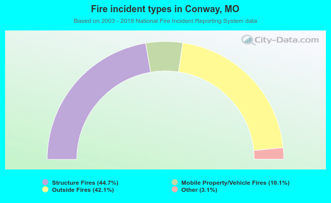 When looking into fire subcategories, the most incidents belonged to: Structure Fires (44.7%), and Outside Fires (42.1%).
| Most common first names in Conway, MO among deceased individuals | ||
| Name | Count | Lived (average) |
|---|---|---|
| James | 23 | 73.9 years |
| William | 20 | 79.4 years |
| John | 16 | 70.9 years |
| Mary | 13 | 76.4 years |
| Charles | 8 | 78.0 years |
| Ida | 8 | 90.5 years |
| Robert | 8 | 67.9 years |
| Clarence | 7 | 77.6 years |
| Martha | 7 | 78.8 years |
| David | 7 | 73.9 years |
| Most common last names in Conway, MO among deceased individuals | ||
| Last name | Count | Lived (average) |
|---|---|---|
| Gann | 13 | 74.5 years |
| Caffey | 11 | 83.0 years |
| Hendrix | 8 | 76.0 years |
| Graves | 8 | 77.5 years |
| Harris | 8 | 80.6 years |
| Mcshane | 7 | 76.0 years |
| Davis | 7 | 76.4 years |
| Green | 7 | 81.7 years |
| Owens | 7 | 84.6 years |
| Wilson | 7 | 65.1 years |
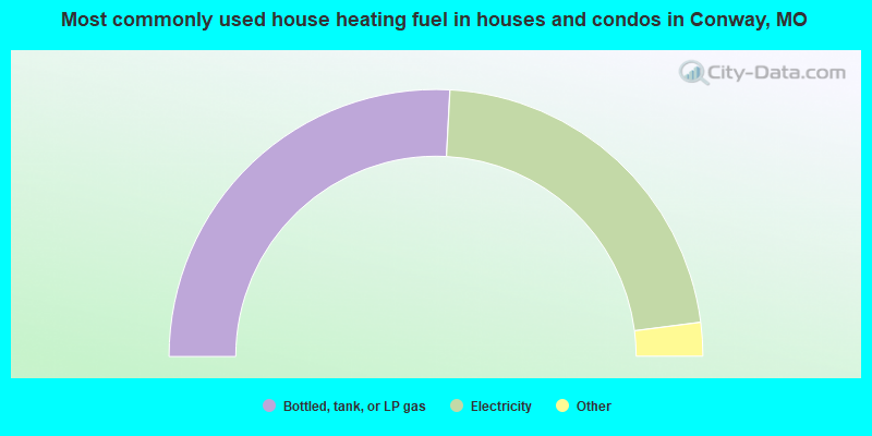
- 51.9%Bottled, tank, or LP gas
- 44.4%Electricity
- 2.7%Utility gas
- 1.1%Other fuel
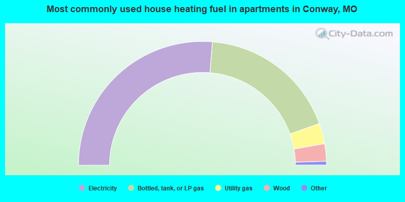
- 53.1%Electricity
- 36.9%Bottled, tank, or LP gas
- 5.4%Utility gas
- 4.6%Wood
Conway compared to Missouri state average:
- Median household income below state average.
- Median house value significantly below state average.
- Unemployed percentage significantly below state average.
- Black race population percentage significantly below state average.
- Hispanic race population percentage significantly below state average.
- Foreign-born population percentage significantly below state average.
- Length of stay since moving in above state average.
- Number of college students below state average.
- Percentage of population with a bachelor's degree or higher significantly below state average.

|
Total of 1 patent application in 2008-2024.