Columbia, Connecticut
Submit your own pictures of this town and show them to the world
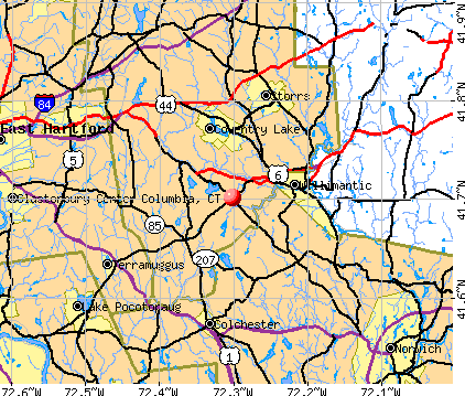
- OSM Map
- General Map
- Google Map
- MSN Map
Population change since 2000: +10.3%
 |
| Males: 2,667 | |
| Females: 2,818 |
| Median resident age: | 45.6 years |
| Connecticut median age: | 39.2 years |
Zip codes: 06237.
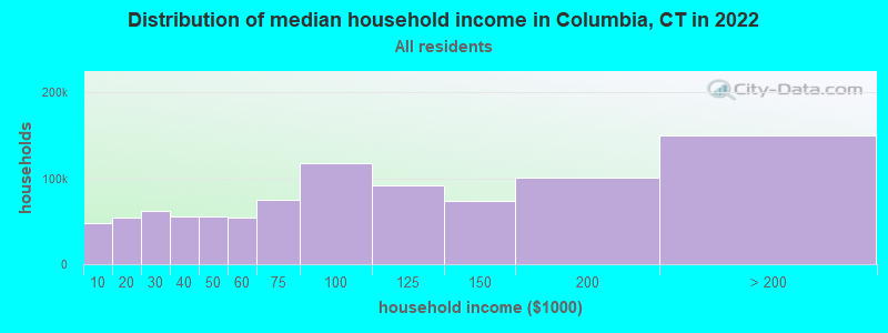
| Columbia: | $115,109 |
| CT: | $88,429 |
Estimated per capita income in 2022: $52,800 (it was $29,446 in 2000)
Columbia town income, earnings, and wages data
Estimated median house or condo value in 2022: $350,443 (it was $162,100 in 2000)
| Columbia: | $350,443 |
| CT: | $347,200 |
Mean prices in 2022: all housing units: $356,092; detached houses: $368,662; townhouses or other attached units: $222,514; in 2-unit structures: $281,599; in 3-to-4-unit structures: $156,197; in 5-or-more-unit structures: $146,539; mobile homes: $46,042
Detailed information about poverty and poor residents in Columbia, CT


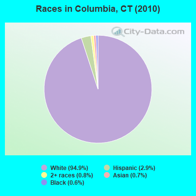
- 5,20394.9%White alone
- 1592.9%Hispanic
- 450.8%Two or more races
- 360.7%Asian alone
- 350.6%Black alone
- 40.07%American Indian alone
- 30.05%Other race alone
Races in Columbia detailed stats: ancestries, foreign born residents, place of birth
According to our research of Connecticut and other state lists, there were 2 registered sex offenders living in Columbia, Connecticut as of May 25, 2024.
The ratio of all residents to sex offenders in Columbia is 2,743 to 1.
The ratio of registered sex offenders to all residents in this city is much lower than the state average.
 Recent articles from our blog. Our writers, many of them Ph.D. graduates or candidates, create easy-to-read articles on a wide variety of topics.

 | Yale Named Best College in US (94 replies) |
| 2024 Connecticut Town Tournament VI (Celebrating the 10-Year Anniversary & Dazzleman's Memorial) (1007 replies) |
| Connecticut Weather Discussion 4 (1252 replies) |
| Economic Climate in CT (18750 replies) |
| Connecticut TOWN TOURNAMENT V (2022) (831 replies) |
| Moving to CT to flee Red States - CT as a Sanctuary State (242 replies) |
Latest news from Columbia, CT collected exclusively by city-data.com from local newspapers, TV, and radio stations
Ancestries: Irish (20.9%), English (16.5%), Italian (14.8%), French (13.6%), German (12.7%), Polish (8.7%).
Current Local Time: EST time zone
Incorporated on 05/1804
Elevation: 510 feet
Land area: 21.4 square miles.
Population density: 257 people per square mile (very low).
293 residents are foreign born (2.7% Europe, 1.5% Latin America, 1.1% Asia).
| This town: | 5.9% |
| Connecticut: | 10.9% |
| Columbia town: | 1.5% ($2,403) |
| Connecticut: | 1.8% ($2,961) |
Nearest city with pop. 50,000+: Manchester, CT  (13.0 miles , pop. 54,740).
Nearest city with pop. 200,000+: Boston, MA (75.3 miles , pop. 589,141).
Nearest city with pop. 1,000,000+: Bronx, NY (101.2 miles , pop. 1,332,650).
Nearest cities:
), ), Latitude: 41.70 N, Longitude: 72.29 W
Area code: 860

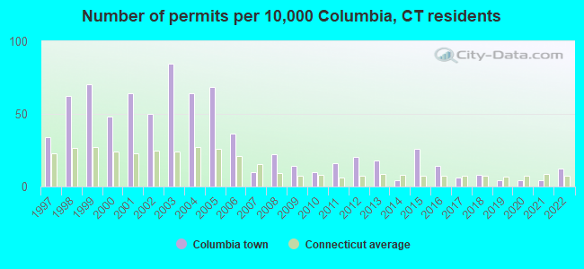
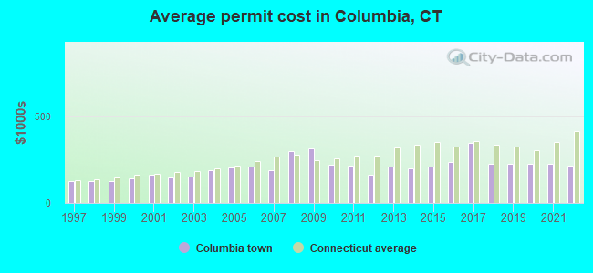
Single-family new house construction building permits:
- 2022: 6 buildings, average cost: $218,300
- 2021: 2 buildings, average cost: $226,300
- 2020: 2 buildings, average cost: $226,300
- 2019: 2 buildings, average cost: $226,300
- 2018: 4 buildings, average cost: $226,300
- 2017: 3 buildings, average cost: $345,000
- 2016: 7 buildings, average cost: $236,100
- 2015: 13 buildings, average cost: $207,600
- 2014: 2 buildings, average cost: $200,000
- 2013: 9 buildings, average cost: $210,900
- 2012: 10 buildings, average cost: $163,000
- 2011: 8 buildings, average cost: $213,700
- 2010: 5 buildings, average cost: $222,300
- 2009: 7 buildings, average cost: $315,600
- 2008: 11 buildings, average cost: $301,100
- 2007: 5 buildings, average cost: $190,000
- 2006: 18 buildings, average cost: $212,400
- 2005: 34 buildings, average cost: $203,600
- 2004: 32 buildings, average cost: $191,200
- 2003: 42 buildings, average cost: $149,600
- 2002: 25 buildings, average cost: $148,400
- 2001: 32 buildings, average cost: $160,500
- 2000: 24 buildings, average cost: $142,500
- 1999: 35 buildings, average cost: $127,100
- 1998: 31 buildings, average cost: $124,600
- 1997: 17 buildings, average cost: $126,700
| Here: | 2.9% |
| Connecticut: | 3.9% |
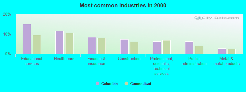
- Educational services (15.0%)
- Health care (11.6%)
- Finance & insurance (8.4%)
- Construction (7.2%)
- Professional, scientific, technical services (6.3%)
- Public administration (6.2%)
- Metal & metal products (2.7%)
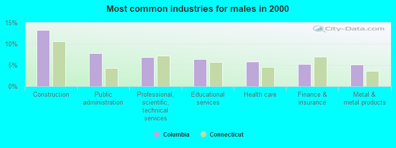
- Construction (13.2%)
- Public administration (7.8%)
- Professional, scientific, technical services (6.8%)
- Educational services (6.4%)
- Health care (5.8%)
- Finance & insurance (5.3%)
- Metal & metal products (5.1%)
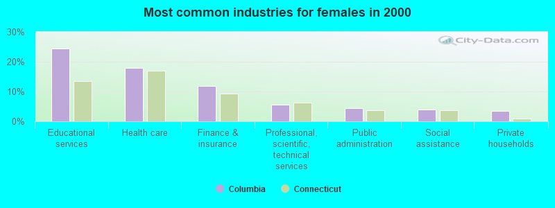
- Educational services (24.5%)
- Health care (17.9%)
- Finance & insurance (11.9%)
- Professional, scientific, technical services (5.6%)
- Public administration (4.5%)
- Social assistance (3.9%)
- Private households (3.5%)
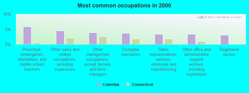
- Preschool, kindergarten, elementary, and middle school teachers (5.9%)
- Other sales and related occupations, including supervisors (4.5%)
- Other management occupations, except farmers and farm managers (3.9%)
- Computer specialists (3.7%)
- Sales representatives, services, wholesale and manufacturing (3.4%)
- Other office and administrative support workers, including supervisors (3.4%)
- Registered nurses (3.1%)

- Other sales and related occupations, including supervisors (6.0%)
- Other management occupations, except farmers and farm managers (5.9%)
- Engineers (5.4%)
- Sales representatives, services, wholesale and manufacturing (5.2%)
- Computer specialists (4.2%)
- Vehicle and mobile equipment mechanics, installers, and repairers (3.7%)
- Electrical equipment mechanics and other installation, maintenance, and repair workers, including supervisors (3.6%)
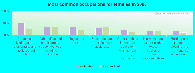
- Preschool, kindergarten, elementary, and middle school teachers (10.2%)
- Other office and administrative support workers, including supervisors (7.0%)
- Registered nurses (6.4%)
- Secretaries and administrative assistants (5.8%)
- Other teachers, instructors, education, training, and library occupations (4.1%)
- Information and record clerks, except customer service representatives (3.5%)
- Building and grounds cleaning and maintenance occupations (3.4%)
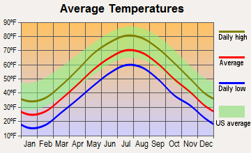
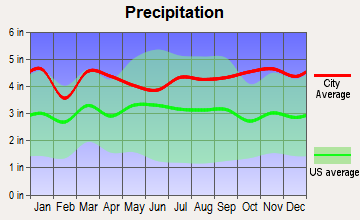
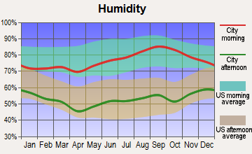
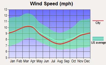
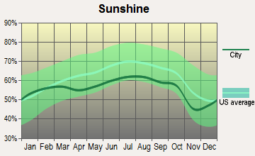
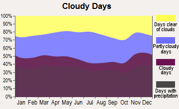
Average climate in Columbia, Connecticut
Based on data reported by over 4,000 weather stations

(lower is better)
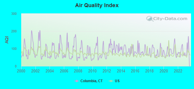
Air Quality Index (AQI) level in 2023 was 94.9. This is worse than average.
| City: | 94.9 |
| U.S.: | 72.6 |
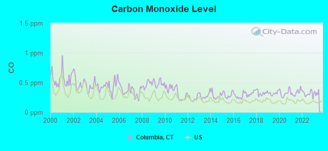
Carbon Monoxide (CO) [ppm] level in 2022 was 0.312. This is worse than average. Closest monitor was 18.3 miles away from the city center.
| City: | 0.312 |
| U.S.: | 0.251 |
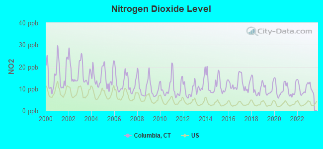
Nitrogen Dioxide (NO2) [ppb] level in 2022 was 10.1. This is significantly worse than average. Closest monitor was 4.1 miles away from the city center.
| City: | 10.1 |
| U.S.: | 5.1 |
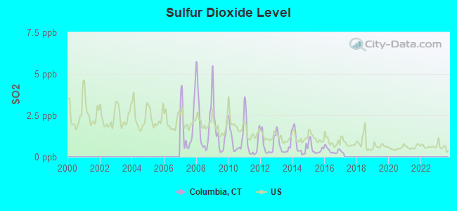
Sulfur Dioxide (SO2) [ppb] level in 2016 was 0.389. This is significantly better than average. Closest monitor was 4.1 miles away from the city center.
| City: | 0.389 |
| U.S.: | 1.515 |
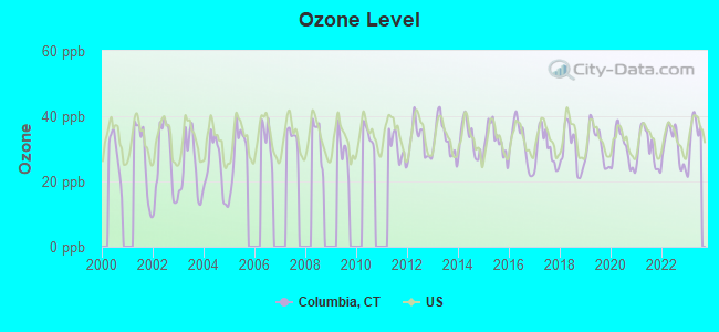
Ozone [ppb] level in 2023 was 34.3. This is about average. Closest monitor was 14.4 miles away from the city center.
| City: | 34.3 |
| U.S.: | 33.3 |
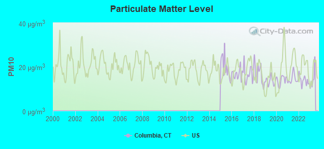
Particulate Matter (PM10) [µg/m3] level in 2022 was 13.8. This is better than average. Closest monitor was 16.7 miles away from the city center.
| City: | 13.8 |
| U.S.: | 19.2 |
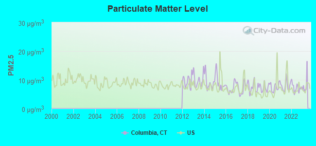
Particulate Matter (PM2.5) [µg/m3] level in 2022 was 7.25. This is about average. Closest monitor was 16.7 miles away from the city center.
| City: | 7.25 |
| U.S.: | 8.11 |
Tornado activity:
Columbia-area historical tornado activity is near Connecticut state average. It is 28% smaller than the overall U.S. average.
On 10/3/1979, a category F4 (max. wind speeds 207-260 mph) tornado 23.0 miles away from the Columbia town center killed 3 people and injured 500 people and caused between $50,000,000 and $500,000,000 in damages.
On 8/21/1951, a category F3 (max. wind speeds 158-206 mph) tornado 13.6 miles away from the town center injured 8 people and caused between $50,000 and $500,000 in damages.
Earthquake activity:
Columbia-area historical earthquake activity is significantly above Connecticut state average. It is 71% smaller than the overall U.S. average.On 10/7/1983 at 10:18:46, a magnitude 5.3 (5.1 MB, 5.3 LG, 5.1 ML, Class: Moderate, Intensity: VI - VII) earthquake occurred 187.1 miles away from the city center
On 4/20/2002 at 10:50:47, a magnitude 5.3 (5.3 ML, Depth: 3.0 mi) earthquake occurred 206.8 miles away from Columbia center
On 4/20/2002 at 10:50:47, a magnitude 5.2 (5.2 MB, 4.2 MS, 5.2 MW, 5.0 MW) earthquake occurred 205.6 miles away from Columbia center
On 1/19/1982 at 00:14:42, a magnitude 4.7 (4.5 MB, 4.7 MD, 4.5 LG, Class: Light, Intensity: IV - V) earthquake occurred 129.2 miles away from the city center
On 10/16/2012 at 23:12:25, a magnitude 4.7 (4.7 ML, Depth: 10.0 mi) earthquake occurred 155.3 miles away from Columbia center
On 8/22/1992 at 12:20:32, a magnitude 4.8 (4.8 MB, 3.8 MS, 4.7 LG, Depth: 6.2 mi) earthquake occurred 207.5 miles away from Columbia center
Magnitude types: regional Lg-wave magnitude (LG), body-wave magnitude (MB), duration magnitude (MD), local magnitude (ML), surface-wave magnitude (MS), moment magnitude (MW)
Natural disasters:
The number of natural disasters in Tolland County (24) is greater than the US average (15).Major Disasters (Presidential) Declared: 13
Emergencies Declared: 11
Causes of natural disasters: Hurricanes: 6, Snowstorms: 5, Storms: 5, Blizzards: 3, Floods: 3, Snows: 3, Winter Storms: 3, Snowfall: 1, Tropical Storm: 1, Wind: 1, Other: 1 (Note: some incidents may be assigned to more than one category).
Hospitals and medical centers near Columbia:
- REGENCY HEIGHTS OF WINDHAM, LLC (Nursing Home, about 4 miles away; WILLIMANTIC, CT)
- WINDHAM COMM MEM HOSP & HATCH HOSP Acute Care Hospitals (about 4 miles away; WILLIMANTIC, CT)
- STAFF MATES HOMECARE (Home Health Center, about 5 miles away; HEBRON, CT)
- VNA EAST INC (Home Health Center, about 6 miles away; MANSFIELD CENTER, CT)
- VISITING NRS AND COMM HEALTH OF (Hospital, about 6 miles away; MANSFIELD CENTER, CT)
- ST JOSEPHS LIVING CENTER (Nursing Home, about 6 miles away; WINDHAM, CT)
- NATCHAUG HOSPITAL (Hospital, about 6 miles away; MANSFIELD CENTER, CT)
Colleges/universities with over 2000 students nearest to Columbia:
- Eastern Connecticut State University (about 5 miles; Willimantic, CT; Full-time enrollment: 4,985)
- University of Connecticut (about 8 miles; Storrs, CT; FT enrollment: 22,037)
- Manchester Community College (about 15 miles; Manchester, CT; FT enrollment: 4,667)
- Three Rivers Community College (about 17 miles; Norwich, CT; FT enrollment: 2,897)
- Goodwin College (about 19 miles; East Hartford, CT; FT enrollment: 3,017)
- Capital Community College (about 21 miles; Hartford, CT; FT enrollment: 2,609)
- Trinity College (about 21 miles; Hartford, CT; FT enrollment: 2,355)
Public elementary/middle school in Columbia:
- HORACE W. PORTER SCHOOL (Students: 647, Location: 3 SCHOOLHOUSE RD, Grades: PK-8)
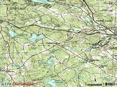
Points of interest:
Notable locations in Columbia: Wells Woods (A), Hop River (B), Columbia Volunteer Fire Department (C). Display/hide their locations on the map
Cemeteries: Columbia Cemetery (1), Utley Hill Cemetery (2). Display/hide their locations on the map
Lakes and reservoirs: Palmer Pond (A), Brousseous Pond (B), Mono Pond (C), Columbia Lake (D). Display/hide their locations on the map
Streams, rivers, and creeks: Macht Brook (A), Clarks Brook (B), Columbia Lake Brook (C), Dam Brook (D). Display/hide their locations on the map
Hotel: Hop River Motel (152 Route 66 East) (1). Display/hide its approximate location on the map
Drinking water stations with addresses in Columbia and their reported violations in the past:
BIRCH HILLS CONDOMINIUMS (Population served: 132, Groundwater):Past health violations:ABBY WATER LLC (Population served: 100, Groundwater):Past monitoring violations:
- MCL, Monthly (TCR) - In SEP-2005, Contaminant: Coliform. Follow-up actions: St Public Notif requested (OCT-04-2005), St Violation/Reminder Notice (OCT-04-2005), St Compliance achieved (MAR-31-2006), St Public Notif received (JUL-10-2008)
- MCL, Monthly (TCR) - In AUG-2005, Contaminant: Coliform. Follow-up actions: St Public Notif requested (SEP-08-2005), St Violation/Reminder Notice (SEP-08-2005), St Public Notif received (SEP-16-2005), St Compliance achieved (MAR-31-2006)
- Monitoring, Repeat Major (TCR) - Between JUL-2005 and SEP-2005, Contaminant: Coliform (TCR). Follow-up actions: St AO (w/penalty) issued (APR-20-2006), St Public Notif requested (APR-20-2006), St Compliance achieved (JUN-13-2006), St Public Notif received (JUN-13-2006)
- One routine major monitoring violation
- One minor monitoring violation
Past monitoring violations:
- Follow-up Or Routine LCR Tap M/R - In OCT-01-2011, Contaminant: Lead and Copper Rule. Follow-up actions: St Public Notif requested (JUN-20-2012), St Formal NOV issued (JUN-20-2012), St Admin Penalty assessed (JUN-20-2012), St Public Notif received (APR-02-2013)
- 53 regular monitoring violations
Drinking water stations with addresses in Columbia that have no violations reported:
- PERRY HILL ESTATES APARTMENTS INC. (Population served: 144, Primary Water Source Type: Groundwater)
- RIDGEVIEW HEIGHTS (Population served: 96, Primary Water Source Type: Groundwater)
| This town: | 2.5 people |
| Connecticut: | 2.5 people |
| This town: | 74.8% |
| Whole state: | 66.3% |
| This town: | 5.9% |
| Whole state: | 6.6% |
Likely homosexual households (counted as self-reported same-sex unmarried-partner households)
- Lesbian couples: 0.6% of all households
- Gay men: 0.3% of all households
| This town: | 4.2% |
| Whole state: | 7.9% |
| This town: | 2.1% |
| Whole state: | 3.9% |
4 people in college/university student housing in 2010
24 people in homes for the mentally retarded in 2000
Banks with branches in Columbia (2011 data):
- First Niagara Bank, National Association: Columbia Branch at 164 Middletown Road, branch established on 1991/08/27. Info updated 2011/06/09: Bank assets: $32,750.6 mil, Deposits: $19,595.4 mil, headquarters in Buffalo, NY, positive income, Commercial Lending Specialization, 351 total offices, Holding Company: First Niagara Financial Group, Inc.
For population 15 years and over in Columbia:
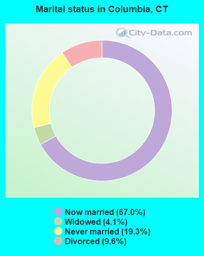
- Never married: 19.3%
- Now married: 67.0%
- Separated: 0.0%
- Widowed: 4.1%
- Divorced: 9.6%
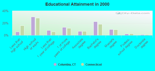
For population 25 years and over in Columbia:
- High school or higher: 94.1%
- Bachelor's degree or higher: 36.0%
- Graduate or professional degree: 13.6%
- Unemployed: 3.1%
- Mean travel time to work (commute): 29.8 minutes
| Here: | 10.3 |
| Connecticut average: | 12.8 |
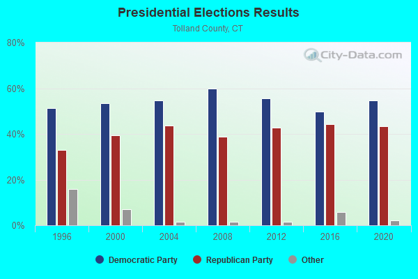
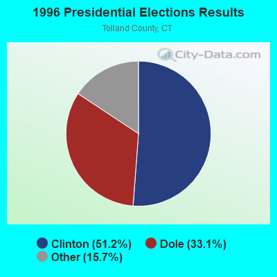
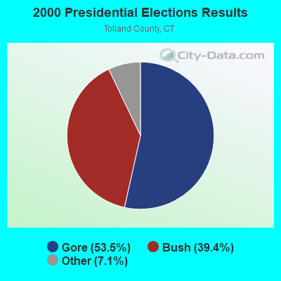
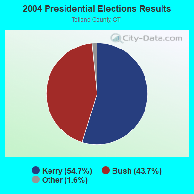
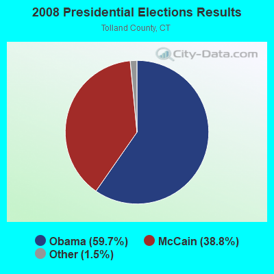
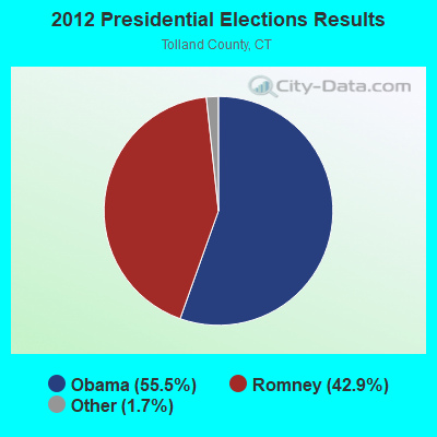
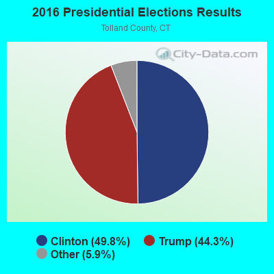
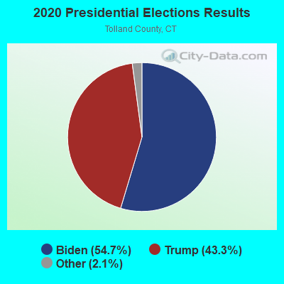
Graphs represent county-level data. Detailed 2008 Election Results
Religion statistics for Columbia, CT (based on Tolland County data)
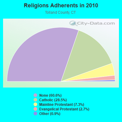
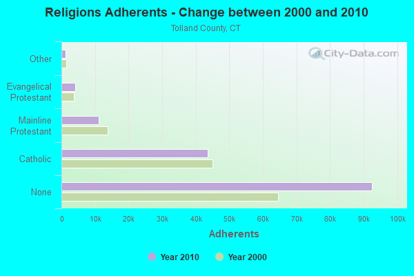
| Religion | Adherents | Congregations |
|---|---|---|
| Catholic | 43,500 | 14 |
| Mainline Protestant | 11,178 | 38 |
| Evangelical Protestant | 4,069 | 27 |
| Other | 1,302 | 8 |
| Orthodox | 100 | 1 |
| None | 92,542 | - |
Food Environment Statistics:
| Tolland County: | 1.36 / 10,000 pop. |
| Connecticut: | 2.21 / 10,000 pop. |
| This county: | 1.15 / 10,000 pop. |
| Connecticut: | 1.02 / 10,000 pop. |
| Tolland County: | 2.24 / 10,000 pop. |
| State: | 2.27 / 10,000 pop. |
| Here: | 6.57 / 10,000 pop. |
| Connecticut: | 9.19 / 10,000 pop. |
| Tolland County: | 6.2% |
| Connecticut: | 7.3% |
| Tolland County: | 21.1% |
| State: | 21.5% |
| Tolland County: | 12.9% |
| Connecticut: | 15.8% |
| Businesses in Columbia, CT | ||||
| Name | Count | Name | Count | |
|---|---|---|---|---|
| 7-Eleven | 1 | Hyundai | 1 | |
| Dunkin Donuts | 1 | U-Haul | 1 | |
| Ford | 1 | |||
Strongest AM radio stations in Columbia:
- WTIC (1080 AM; 50 kW; HARTFORD, CT; Owner: INFINITY RADIO OPERATIONS INC.)
- WNNZ (640 AM; 50 kW; WESTFIELD, MA; Owner: CLEAR CHANNEL BROADCASTING LICENSES, INC.)
- WCRN (830 AM; 50 kW; WORCESTER, MA; Owner: CARTER BROADCASTING CORPORATION)
- WALE (990 AM; 50 kW; GREENVILLE, RI; Owner: NORTH AMERICAN BROADCASTING CO., INC.)
- WILI (1400 AM; 1 kW; WILLIMANTIC, CT; Owner: THE NUTMEG BROADCASTING CO.)
- WVNE (760 AM; daytime; 25 kW; LEICESTER, MA; Owner: BLOUNT MASSCOM, INC.)
- WICH (1310 AM; 5 kW; NORWICH, CT; Owner: WICH, INCORPORATED)
- WEEI (850 AM; 50 kW; BOSTON, MA; Owner: ENTERCOM BOSTON LICENSE, LLC)
- WKOX (1200 AM; 50 kW; FRAMINGHAM, MA; Owner: CAPSTAR TX LIMITED PARTNERSHIP)
- WRKO (680 AM; 50 kW; BOSTON, MA; Owner: ENTERCOM BOSTON LICENSE, LLC)
- WBIX (1060 AM; 40 kW; NATICK, MA; Owner: LANGER BROADCASTING CORPORATION)
- WAMG (890 AM; 25 kW; DEDHAM, MA; Owner: MEGA COMMUNICATIONS OF DEDHAM LICENSEE, LLC)
- WDRC (1360 AM; 5 kW; HARTFORD, CT; Owner: BUCKLEY BROADCASTING CORPORATION)
Strongest FM radio stations in Columbia:
- WILI-FM (98.3 FM; WILLIMANTIC, CT; Owner: NUTMEG BROADCASTING COMPANY)
- WECS (90.1 FM; WILLIMANTIC, CT; Owner: EASTERN CONNECTICUT STATE COLLEGE)
- WHUS (91.7 FM; STORRS, CT; Owner: THE BD. OF TRUSTEES, THE UNIV. OF CT)
- W258AC (99.5 FM; STORRS, CT; Owner: CONNECTICUT PUBLIC BROADCASTING, INC)
- WRCH (100.5 FM; NEW BRITAIN, CT; Owner: INFINITY RADIO OPERATIONS INC.)
- WTIC-FM (96.5 FM; HARTFORD, CT; Owner: INFINITY RADIO OPERATIONS INC.)
- WWUH (91.3 FM; WEST HARTFORD, CT; Owner: UNIVERSITY OF HARTFORD)
- WKSS (95.7 FM; HARTFORD-MERIDEN, CT; Owner: CAPSTAR TX LIMITED PARTNERSHIP)
- WWYZ (92.5 FM; WATERBURY, CT; Owner: CAPSTAR TX LIMITED PARTNERSHIP)
- WZMX (93.7 FM; HARTFORD, CT; Owner: INFINITY RADIO OPERATIONS INC.)
- WHCN (105.9 FM; HARTFORD, CT; Owner: CAPSTAR TX LIMITED PARTNERSHIP)
- WCCC-FM (106.9 FM; HARTFORD, CT; Owner: MARLIN BROADCASTING, LLC)
- WMRQ (104.1 FM; WATERBURY, CT; Owner: CAPSTAR TX LIMITED PARTNERSHIP)
- WPKT (90.5 FM; MERIDEN, CT; Owner: CONNECTICUT PUBLIC BROADCASTING, INC)
- WDRC-FM (102.9 FM; HARTFORD, CT; Owner: BUCKLEY BROADCASTING CORPORATION)
- WCTY (97.7 FM; NORWICH, CT; Owner: WICH, INC.)
- WKCI-FM (101.3 FM; HAMDEN, CT; Owner: CLEAR CHANNEL BROADCASTING LICENSES, INC.)
- WBMW (106.5 FM; LEDYARD, CT; Owner: RED WOLF BROADCASTING CORPORATION)
- WAQY (102.1 FM; SPRINGFIELD, MA; Owner: SAGA COMMUNICATIONS OF NEW ENGLAND, LLC)
- WPLR (99.1 FM; NEW HAVEN, CT; Owner: COX RADIO, INC.)
TV broadcast stations around Columbia:
- WHPX (Channel 26; NEW LONDON, CT; Owner: PAXSON HARTFORD LICENSE, INC.)
- WTIC-TV (Channel 61; HARTFORD, CT; Owner: TRIBUNE TELEVISION COMPANY)
- W11BJ (Channel 11; HARTFORD, CT; Owner: COMMUNICATIONS SITE MANAGEMENT LLC)
- WTXX (Channel 20; WATERBURY, CT; Owner: WTXX INC.)
- WUVN (Channel 18; HARTFORD, CT; Owner: ENTRAVISION HOLDINGS, LLC)
- WPXQ (Channel 69; BLOCK ISLAND, RI; Owner: OCEAN STATE TELEVISION, L.L.C.)
- WEDN (Channel 53; NORWICH, CT; Owner: CONNECTICUT PUBLIC BROADCASTING, INC.)
- WVIT (Channel 30; NEW BRITAIN, CT; Owner: OUTLET BROADCASTING, INC)
- WYDN (Channel 48; WORCESTER, MA; Owner: EDUCATIONAL PUBLIC TV CORPORATION)
- WEDH (Channel 24; HARTFORD, CT; Owner: CONNECTICUT PUBLIC BROADCASTING, INC.)
- WFSB (Channel 3; HARTFORD, CT; Owner: MEREDITH CORPORATION)
- WTNH (Channel 8; NEW HAVEN, CT; Owner: WTNH BROADCASTING, INC.)
- WHTX-LP (Channel 10; HARTFORD, CT; Owner: ENTRAVISION HOLDINGS, LLC)
- WCTX (Channel 59; NEW HAVEN, CT; Owner: WTNH BROADCASTING, INC.)
- WEDY (Channel 65; NEW HAVEN, CT; Owner: CONNECTICUT PUBLIC BROADCASTING, INC.)
- WRDM-LP (Channel 13; HARTFORD, CT; Owner: ZGS HARTFORD, INC.)
- WMLD-LP (Channel 6; HARTFORD, CT; Owner: HARVARD BROADCASTING, INC.)
- WHCT-LP (Channel 38; HARTFORD, CT; Owner: VENTURE TECHNOLOGIES GROUP, LLC)
- National Bridge Inventory (NBI) Statistics
- 6Number of bridges
- 69ft / 21.2mTotal length
- 33,350Total average daily traffic
- 1,859Total average daily truck traffic
- 49,556Total future (year 2036) average daily traffic
FCC Registered Amateur Radio Licenses:
30 (See the full list of FCC Registered Amateur Radio Licenses in Columbia)FAA Registered Aircraft Manufacturers and Dealers:
1- A P SHIFRIN INC, Po Box 132, Columbia, CT 06237
Certificate: 03-0141 (Corporation), Certificate Issue Date: 01/23/2003, Expiration Date: 01/22/2004
FAA Registered Aircraft:
6- Aircraft: BEECH 77 (Category: Land, Seats: 2, Weight: Up to 12,499 Pounds), Engine: LYCOMING 0-235 SERIES (115 HP) (Reciprocating)
N-Number: 1820W, N1820W, N-1820W, Serial Number: WA-289, Year manufactured: 1981, Airworthiness Date: 12/11/1981, Certificate Issue Date: 03/02/2020
Registrant (LLC): A&p Paul LLC, 15 Latham Hill Rd, Columbia, CT 06237 - Aircraft: BAKER DARYL BUSH SPORT 200 (Category: Land, Seats: 4, Weight: Up to 12,499 Pounds), Engine: LYCOMING IO-360-A3B6D (200 HP) (Reciprocating)
N-Number: 4625D, N4625D, N-4625D, Serial Number: 21056, Year manufactured: 2005, Airworthiness Date: 05/11/2006, Certificate Issue Date: 02/27/2004
Registrant (Individual): Daryl Baker, 211a Pine St, Columbia, CT 06237 - Aircraft: MOONEY M20J (Category: Land, Seats: 4, Weight: Up to 12,499 Pounds, Speed: 126 mph), Engine: Reciprocating
N-Number: 5786Z, N5786Z, N-5786Z, Serial Number: 24-1523, Year manufactured: 1984, Airworthiness Date: 12/21/1984, Certificate Issue Date: 03/02/2017
Registrant (Individual): Robert P Campagnone, 80 Johnson Rd, Columbia, CT 06237 - Aircraft: AIRCRAFT MFG & DEVELOPMENT CO CH 2000 (Category: Land, Seats: 2, Weight: Up to 12,499 Pounds), Engine: LYCOMING 0-235 SERIES (115 HP) (4 Cycle)
N-Number: 622AM, N622AM, N-622AM, Serial Number: 20-1023, Year manufactured: 2003, Airworthiness Date: 11/17/2003, Certificate Issue Date: 03/03/2020
Registrant (LLC): A&p Paul LLC, 15 Latham Hill Rd, Columbia, CT 06237 - Aircraft: GRUMMAN AMERICAN AVN. CORP. AA-5B (Category: Land, Seats: 4, Weight: Up to 12,499 Pounds, Speed: 105 mph), Engine: LYCOMING O&VO-360 SER (180 HP) (Reciprocating)
N-Number: 74820, N74820, N-74820, Serial Number: AA5B0368, Year manufactured: 1976, Airworthiness Date: 10/25/1976, Certificate Issue Date: 11/06/2009
Registrant (Individual): Brian W King, 9 Scalise Dr, Columbia, CT 06237 - Aircraft: CESSNA 180 (Category: Land, Seats: 4, Weight: Up to 12,499 Pounds, Speed: 121 mph), Engine: CONT MOTOR O-470 SERIES (230 HP) (Reciprocating)
N-Number: 7605A, N7605A, N-7605A, Serial Number: 32502, Year manufactured: 1956
Registrant (Individual): John Naumec, Hop River Poultry Farm, Columbia, CT 06237
Deregistered: Cancel Date: 11/21/2017
2002 - 2018 National Fire Incident Reporting System (NFIRS) incidents
- Fire incident types reported to NFIRS in Columbia, CT
- 18560.9%Structure Fires
- 4213.8%Outside Fires
- 4113.5%Other
- 3611.8%Mobile Property/Vehicle Fires
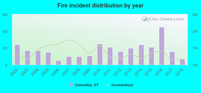 Based on the data from the years 2002 - 2018 the average number of fires per year is 18. The highest number of fires - 45 took place in 2016, and the least - 5 in 2006. The data has a dropping trend.
 When looking into fire subcategories, the most incidents belonged to: Structure Fires (60.9%), and Outside Fires (13.8%).
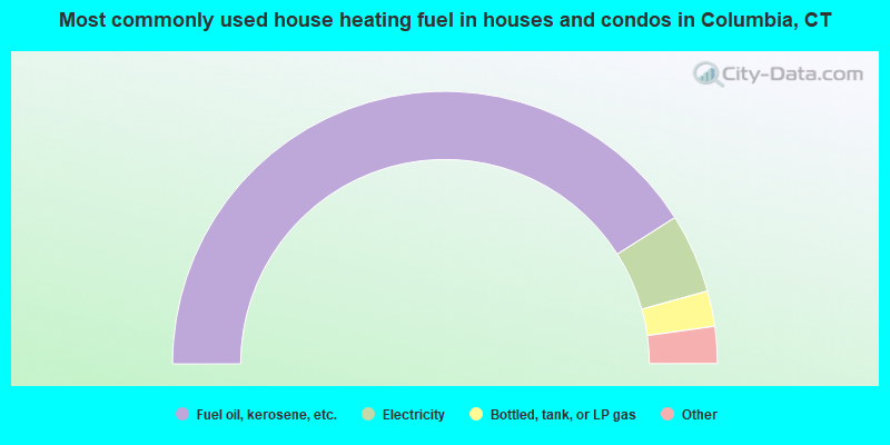
- 81.9%Fuel oil, kerosene, etc.
- 9.4%Electricity
- 4.2%Bottled, tank, or LP gas
- 4.0%Wood
- 0.5%Utility gas
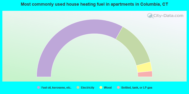
- 66.2%Fuel oil, kerosene, etc.
- 25.3%Electricity
- 5.2%Wood
- 3.2%Bottled, tank, or LP gas
Columbia compared to Connecticut state average:
- Unemployed percentage significantly below state average.
- Black race population percentage significantly below state average.
- Hispanic race population percentage significantly below state average.
- Median age above state average.
- Foreign-born population percentage significantly below state average.
- Renting percentage significantly below state average.
- Length of stay since moving in significantly above state average.
- Number of rooms per house significantly below state average.
- House age significantly below state average.
Columbia on our top lists:
- #8 on the list of "Top 101 cities with largest percentage of males in industries: metals and minerals, except petroleum, merchant wholesalers (population 5,000+)"
- #13 on the list of "Top 101 cities with largest percentage of females in occupations: electricians (population 5,000+)"
- #13 on the list of "Top 101 cities with largest percentage of males in industries: miscellaneous durable goods merchant wholesalers (population 5,000+)"
- #16 on the list of "Top 101 cities with largest percentage of females in occupations: preschool, kindergarten, elementary and middle school teachers (population 5,000+)"
- #21 on the list of "Top 101 cities with largest percentage of females in industries: private households (population 5,000+)"
- #24 on the list of "Top 101 cities with largest percentage of males in occupations: therapists (population 5,000+)"
- #35 on the list of "Top 101 cities with largest percentage of females in occupations: special education teachers (population 5,000+)"
- #45 on the list of "Top 101 cities with largest percentage of females in occupations: other transportation workers (population 5,000+)"
- #47 on the list of "Top 101 cities with largest percentage of females in occupations: secondary school teachers (population 5,000+)"
- #49 on the list of "Top 101 cities with largest percentage of males in industries: motor vehicle and parts dealers (population 5,000+)"
- #53 on the list of "Top 101 cities with largest percentage of males in industries: electronic shopping and mail-order houses (population 5,000+)"
- #58 on the list of "Top 101 cities with largest percentage of males in industries: alcoholic beverages merchant wholesalers (population 5,000+)"
- #58 on the list of "Top 101 cities with largest percentage of males in industries: health and personal care, except drug, stores (population 5,000+)"
- #62 on the list of "Top 101 cities with largest percentage of males in industries: furniture and home furnishing merchant wholesalers (population 5,000+)"
- #67 on the list of "Top 101 cities with largest percentage of females in industries: drugs, sundries, and chemical and allied products merchant wholesalers (population 5,000+)"
- #74 on the list of "Top 101 cities with largest percentage of females in industries: sewing, needlework, and piece goods stores (population 5,000+)"
- #76 on the list of "Top 101 cities with largest percentage of females in industries: data processing, libraries, and other information services (population 5,000+)"
- #92 on the list of "Top 101 cities with largest percentage of males in industries: private households (population 5,000+)"
- #100 on the list of "Top 101 cities with largest percentage of females in industries: radio, tv, and computer stores (population 5,000+)"
- #8 on the list of "Top 101 counties with the lowest number of births per 1000 residents 2007-2013"
- #10 on the list of "Top 101 counties with the largest decrease in the number of births per 1000 residents 2000-2006 to 2007-2013 (pop 50,000+)"
- #19 on the list of "Top 101 counties with the best general health status score of residents (1-5), 3 years of data"
- #21 on the list of "Top 101 counties with the highest percentage of residents that visited a dentist within the past year"
- #44 on the list of "Top 101 counties with the highest percentage of residents that exercised in the past month"
State forum archive:

|
|
Total of 88 patent applications in 2008-2024.