Colson, Kentucky
Submit your own pictures of this place and show them to the world
- OSM Map
- General Map
- Google Map
- MSN Map

| Males: 719 | |
| Females: 715 |
| Median resident age: | 37.2 years |
| Kentucky median age: | 35.9 years |
Zip code: 41858
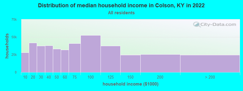
| Colson: | $27,586 |
| KY: | $59,341 |
Estimated per capita income in 2022: $18,238 (it was $9,165 in 2000)
Colson CCD income, earnings, and wages data
Estimated median house or condo value in 2022: $80,373 (it was $39,200 in 2000)
| Colson: | $80,373 |
| KY: | $196,300 |
Mean prices in 2022: all housing units: $114,459; detached houses: $128,463; townhouses or other attached units: $64,774; mobile homes: $82,859
Detailed information about poverty and poor residents in Colson, KY
Compare current foreclosures near Colson, KY:
| Photo | Address | Area | Beds / Baths | Price | Details |
|---|---|---|---|---|---|

|
#1
Cornelia Ave
Whitesburg, KY 41858
|
1,894 sq. feet
|
2 baths 3 beds |
show details | |

|
#2
Shady Crk
Leburn, KY 41831
|
1,468 sq. feet
|
2 baths 3 beds |
show details | |

|
#3
Ky Route 7
Wayland, KY 41666
|
1,522 sq. feet
|
2 baths 3 beds |
show details | |

|
#4
Ventura Rd
Clintwood, VA 24228
|
1,588 sq. feet
|
2 baths 3 beds |
show details | |

|
#5
Shepherds Dr
Garrett, KY 41630
|
1,148 sq. feet
|
1 baths 3 beds |
show details | |

|
#6
Helton Hl
Melvin, KY 41650
|
864 sq. feet
|
1 baths 2 beds |
show details | |

|
#7
Parks St
Whitesburg, KY 41858
|
752 sq. feet
|
1 baths 2 beds |
show details | |

|
#8
Caney Newsome Br
Pikeville, KY 41501
|
1,294 sq. feet
|
2 baths 2 beds |
show details | |

|
#9
Haynes Dr
Hindman, KY 41822
|
1,728 sq. feet
|
2 baths 5 beds |
show details | |

|
#10
Yellow Creek Rd
Sassafras, KY 41759
|
1,228 sq. feet
|
1 baths 2 beds |
show details |
| Photo | Address | Area | Beds / Baths | Price | Details |
|---|---|---|---|---|---|

|
#11
Little Robinson Creek Btm
Virgie, KY 41572
|
1,000 sq. feet
|
1 baths 3 beds |
show details | |

|
#12
Little Robinson Crk
Virgie, KY 41572
|
1,280 sq. feet
|
1 baths 3 beds |
show details | |

|
#13
Blaze Br
Jenkins, KY 41537
|
1,600 sq. feet
|
3 baths 3 beds |
show details | |

|
#14
Highway 721
Hazard, KY 41701
|
984 sq. feet
|
1 baths 2 beds |
show details | |

|
#15
Highway 160 S
Littcarr, KY 41834
|
2,642 sq. feet
|
1 baths 3 beds |
show details | |

|
#16
Elkhorn Crk
Shelby Gap, KY 41563
|
1,014 sq. feet
|
1 baths 3 beds |
show details | |

|
#17
Charlie Bentley Holw
Beaver, KY 41604
|
864 sq. feet
|
1 baths 3 beds |
show details | |

|
#18
Sandlick Branch Rd
Emmalena, KY 41740
|
1,512 sq. feet
|
1 baths 3 beds |
show details | |

|
#19
Dry Creek Rd
Topmost, KY 41862
|
864 sq. feet
|
- baths 2 beds |
show details | |

|
#20
Short Fork Rd
Pippa Passes, KY 41844
|
1,330 sq. feet
|
- baths 2 beds |
show details |
| Photo | Address | Area | Beds / Baths | Price | Details |
|---|---|---|---|---|---|

|
#21
Highway 582
Kite, KY 41828
|
952 sq. feet
|
- baths 2 beds |
show details | |

|
#22
Circle St
Wheelwright, KY 41669
|
- sq. feet
|
1 baths 3 beds |
show details | |

|
#23
Curt Hicks Drive
Carrie, KY 41725
|
- sq. feet
|
- baths - beds |
show details | |

|
#24
Big Lick Br
Mc Dowell, KY 41647
|
- sq. feet
|
- baths - beds |
show details | |

|
#25
Goldenrod Ln
Vicco, KY 41773
|
- sq. feet
|
- baths - beds |
show details | |

|
#26
Montgomery Creek Rd
Vicco, KY 41773
|
- sq. feet
|
- baths - beds |
show details | |

|
#27
Possum Trot Rd
Leburn, KY 41831
|
- sq. feet
|
- baths - beds |
show details | |

|
#28
Campbell Town Rd
Cornettsville, KY 41731
|
- sq. feet
|
- baths - beds |
show details | |

|
#29
Highway 550 W
Hindman, KY 41822
|
- sq. feet
|
- baths - beds |
show details | |

|
#30
Old Dixon Rd
Blackey, KY 41804
|
- sq. feet
|
- baths - beds |
show details |
| Photo | Address | Area | Beds / Baths | Price | Details |
|---|---|---|---|---|---|

|
#31
Lincoln Ct
Hi Hat, KY 41636
|
- sq. feet
|
- baths - beds |
show details | |

|
#32
Desiree Ln
Hazard, KY 41701
|
- sq. feet
|
- baths - beds |
show details | |

|
#33
Possum Trot Rd
Leburn, KY 41831
|
- sq. feet
|
- baths - beds |
show details | |

|
#34
Johnny Hall Holw
Virgie, KY 41572
|
- sq. feet
|
- baths - beds |
show details | |

|
#35
Kenny Phillips Rd
Eolia, KY 40826
|
- sq. feet
|
- baths - beds |
show details | |

|
#36
Couch Dr
Cornettsville, KY 41731
|
- sq. feet
|
- baths - beds |
show details | |

|
#37
Cane Holw
Whitesburg, KY 41858
|
- sq. feet
|
- baths - beds |
show details | |

|
#38
Highway 1103
Hallie, KY 41821
|
- sq. feet
|
- baths - beds |
show details | |

|
#39
Bent Branch Rd
Cornettsville, KY 41731
|
- sq. feet
|
- baths - beds |
show details | |

|
#40
Highway 160
Linefork, KY 41833
|
- sq. feet
|
- baths - beds |
show details |
| Photo | Address | Area | Beds / Baths | Price | Details |
|---|---|---|---|---|---|

|
#41
Lotts Creek Rd
Hazard, KY 41701
|
- sq. feet
|
- baths - beds |
show details | |

|
#42
Hall Mountain Rd
Viper, KY 41774
|
- sq. feet
|
- baths - beds |
show details | |

|
#43
Red Morg Br
Teaberry, KY 41660
|
- sq. feet
|
- baths - beds |
show details | |

|
#44
Low Wood Dr
Pound, VA 24279
|
- sq. feet
|
- baths - beds |
show details | |

|
#45
Jacks Br
Hazard, KY 41701
|
- sq. feet
|
- baths - beds |
show details | |

|
#46
Highway 3403
Partridge, KY 40862
|
- sq. feet
|
- baths - beds |
show details | |

|
#47
Frogtown Rd
Pikeville, KY 41501
|
- sq. feet
|
- baths - beds |
show details | |

|
#48
S Ky Highway 15
Happy, KY 41746
|
- sq. feet
|
- baths - beds |
show details | |

|
#49
Little Fork Rd
Virgie, KY 41572
|
- sq. feet
|
- baths - beds |
show details | |

|
Check over 1 million property listings on Foreclosure.com!
|
browse all offers | |||

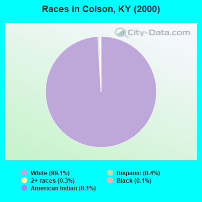
- 1,49699.1%White alone
- 60.4%Hispanic
- 40.3%Two or more races
- 20.1%Black alone
- 20.1%American Indian alone
Races in Colson detailed stats: ancestries, foreign born residents, place of birth
 Recent articles from our blog. Our writers, many of them Ph.D. graduates or candidates, create easy-to-read articles on a wide variety of topics.
Current Local Time: EST time zone
Elevation: 1163 feet
Land area: 32.8 square miles.
Population density: 44 people per square mile (very low).

| Colson CCD: | 0.6% ($227) |
| Kentucky: | 0.8% ($610) |
Nearest city with pop. 50,000+: Johnson City, TN  (66.6 miles , pop. 55,469).
Nearest city with pop. 200,000+: Fayette, KY (107.3 miles , pop. 260,512).
Nearest city with pop. 1,000,000+: Chicago, IL (410.9 miles , pop. 2,896,016).
Nearest cities:
), ), ), )Latitude: 37.23 N, Longitude: 82.82 W
Area code commonly used in this area: 606

| Here: | 5.9% |
| Kentucky: | 3.8% |
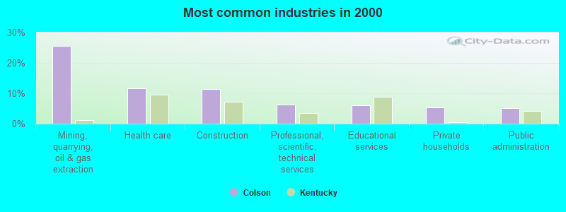
- Mining, quarrying, oil & gas extraction (25.6%)
- Health care (11.6%)
- Construction (11.3%)
- Professional, scientific, technical services (6.2%)
- Educational services (6.0%)
- Private households (5.4%)
- Public administration (5.1%)
- Mining, quarrying, oil & gas extraction (37.0%)
- Construction (20.1%)
- Wood products (7.9%)
- Motor vehicle & parts dealers (7.4%)
- Public administration (5.8%)
- Administrative & support & waste management services (5.8%)
- Private households (5.3%)
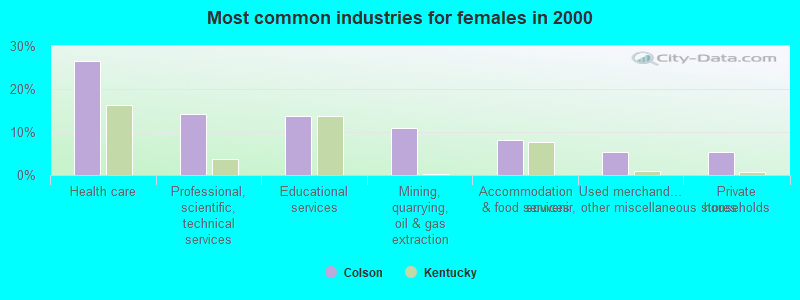
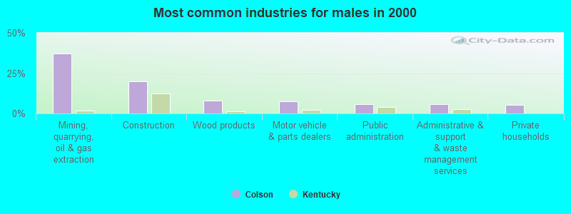
- Health care (26.5%)
- Professional, scientific, technical services (14.3%)
- Educational services (13.6%)
- Mining, quarrying, oil & gas extraction (10.9%)
- Accommodation & food services (8.2%)
- Used merchandise, gift, novelty, souvenir, other miscellaneous stores (5.4%)
- Private households (5.4%)
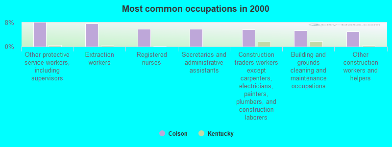
- Other protective service workers, including supervisors (8.0%)
- Extraction workers (7.7%)
- Registered nurses (6.0%)
- Secretaries and administrative assistants (6.0%)
- Construction traders workers except carpenters, electricians, painters, plumbers, and construction laborers (5.7%)
- Building and grounds cleaning and maintenance occupations (5.4%)
- Other construction workers and helpers (5.1%)
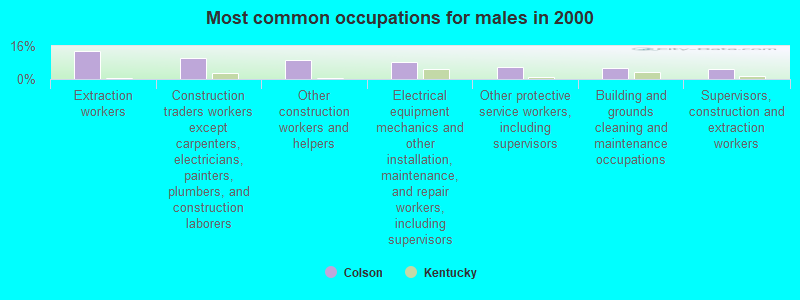
- Extraction workers (13.8%)
- Construction traders workers except carpenters, electricians, painters, plumbers, and construction laborers (10.1%)
- Other construction workers and helpers (9.0%)
- Electrical equipment mechanics and other installation, maintenance, and repair workers, including supervisors (8.5%)
- Other protective service workers, including supervisors (5.8%)
- Building and grounds cleaning and maintenance occupations (5.3%)
- Supervisors, construction and extraction workers (4.8%)
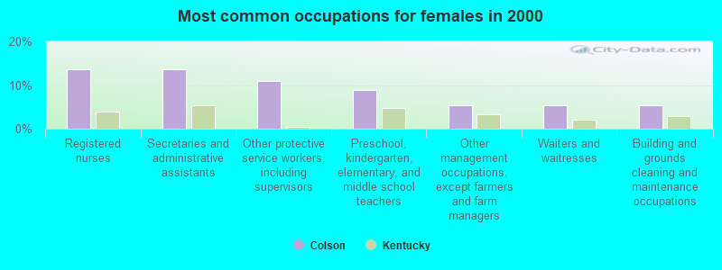
- Registered nurses (13.6%)
- Secretaries and administrative assistants (13.6%)
- Other protective service workers, including supervisors (10.9%)
- Preschool, kindergarten, elementary, and middle school teachers (8.8%)
- Other management occupations, except farmers and farm managers (5.4%)
- Waiters and waitresses (5.4%)
- Building and grounds cleaning and maintenance occupations (5.4%)
Average climate in Colson, Kentucky
Based on data reported by over 4,000 weather stations


(lower is better)
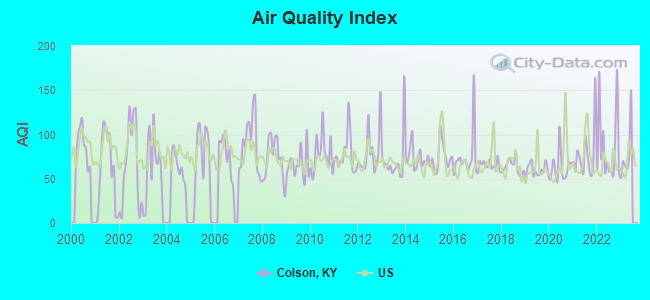
Air Quality Index (AQI) level in 2022 was 85.4. This is about average.
| City: | 85.4 |
| U.S.: | 72.6 |
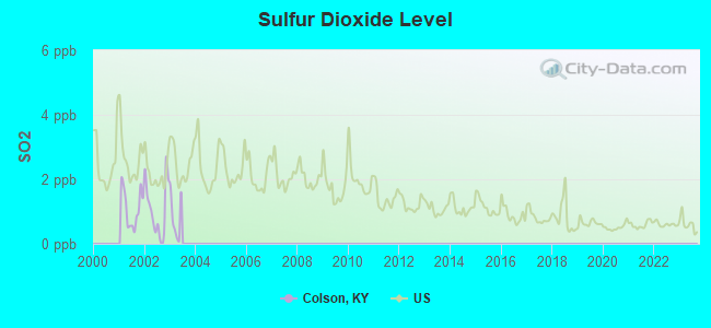
Sulfur Dioxide (SO2) [ppb] level in 2002 was 1.08. This is significantly better than average. Closest monitor was 20.1 miles away from the city center.
| City: | 1.08 |
| U.S.: | 1.51 |
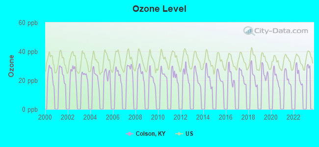
Ozone [ppb] level in 2022 was 23.5. This is significantly better than average. Closest monitor was 14.3 miles away from the city center.
| City: | 23.5 |
| U.S.: | 33.3 |
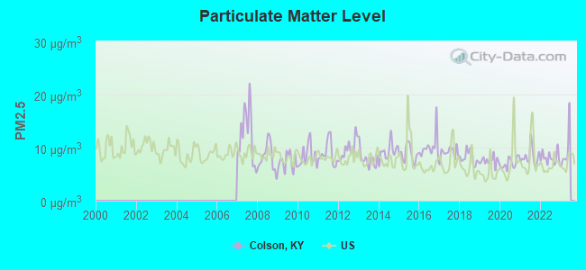
Particulate Matter (PM2.5) [µg/m3] level in 2022 was 8.06. This is about average. Closest monitor was 21.9 miles away from the city center.
| City: | 8.06 |
| U.S.: | 8.11 |
Tornado activity:
Colson-area historical tornado activity is significantly below Kentucky state average. It is 74% smaller than the overall U.S. average.
On 5/18/1995, a category F2 (max. wind speeds 113-157 mph) tornado 11.1 miles away from the Colson place center caused between $50,000 and $500,000 in damages.
On 4/4/1974, a category F3 (max. wind speeds 158-206 mph) tornado 56.0 miles away from the place center killed one person and injured 4 people and caused between $50,000 and $500,000 in damages.
Earthquake activity:
Colson-area historical earthquake activity is significantly above Kentucky state average. It is 32% greater than the overall U.S. average.On 7/27/1980 at 18:52:21, a magnitude 5.2 (5.1 MB, 4.7 MS, 5.0 UK, 5.2 UK, Class: Moderate, Intensity: VI - VII) earthquake occurred 91.4 miles away from the city center
On 8/9/2020 at 12:07:37, a magnitude 5.1 (5.1 MW, Depth: 4.7 mi) earthquake occurred 108.7 miles away from Colson center
On 8/23/2011 at 17:51:04, a magnitude 5.8 (5.8 MW, Depth: 3.7 mi) earthquake occurred 271.6 miles away from the city center
On 9/7/1988 at 02:28:09, a magnitude 4.6 (4.5 MB, 4.6 LG, Class: Light, Intensity: IV - V) earthquake occurred 85.8 miles away from the city center
On 11/30/1973 at 07:48:41, a magnitude 4.7 (4.7 MB, 4.6 ML) earthquake occurred 117.7 miles away from the city center
On 11/10/2012 at 17:08:14, a magnitude 4.2 (4.2 MW, Depth: 10.6 mi) earthquake occurred 14.5 miles away from the city center
Magnitude types: regional Lg-wave magnitude (LG), body-wave magnitude (MB), local magnitude (ML), surface-wave magnitude (MS), moment magnitude (MW)
Natural disasters:
The number of natural disasters in Letcher County (30) is a lot greater than the US average (15).Major Disasters (Presidential) Declared: 25
Emergencies Declared: 2
Causes of natural disasters: Floods: 23, Storms: 19, Mudslides: 9, Tornadoes: 7, Landslides: 6, Winter Storms: 4, Winds: 3, Snows: 2, Snowstorms: 2, Blizzard: 1, Flash Flood: 1, Freeze: 1, Heavy Rain: 1, Hurricane: 1, Snowfall: 1, Other: 1 (Note: some incidents may be assigned to more than one category).
Colleges/universities with over 2000 students nearest to Colson:
- Hazard Community and Technical College (about 20 miles; Hazard, KY; Full-time enrollment: 2,087)
- Southeast Kentucky Community and Technical College (about 21 miles; Cumberland, KY; FT enrollment: 2,196)
- Big Sandy Community and Technical College (about 32 miles; Prestonsburg, KY; FT enrollment: 2,660)
- Northeast State Community College (about 57 miles; Blountville, TN; FT enrollment: 4,480)
- King University (about 58 miles; Bristol, TN; FT enrollment: 2,472)
- Lincoln Memorial University (about 65 miles; Harrogate, TN; FT enrollment: 3,706)
- East Tennessee State University (about 69 miles; Johnson City, TN; FT enrollment: 12,774)
Points of interest:
Notable location: Colson Volunteer Fire Department (A). Display/hide its location on the map
Churches in Colson include: Rockhouse Church (A), Mill Creek Church (B). Display/hide their locations on the map
Cemeteries: Collins Cemetery (1), Cook Cemetery (2). Display/hide their locations on the map
Streams, rivers, and creeks: Appletree Branch (A), Beaverdam Branch (B), Big Branch (C), Dick Branch (D), Trace Fork (E), Camp Fork (F), Camp Branch (G), Stevens Fork (H), Buck Creek (I). Display/hide their locations on the map
| This place: | 2.5 people |
| Kentucky: | 2.5 people |
| This place: | 69.3% |
| Whole state: | 66.9% |
| This place: | 7.8% |
| Whole state: | 6.4% |
Likely homosexual households (counted as self-reported same-sex unmarried-partner households)
- Lesbian couples: 0.3% of all households
- Gay men: 0.3% of all households
| This place: | 39.7% |
| Whole state: | 15.8% |
| This place: | 19.5% |
| Whole state: | 6.6% |
For population 15 years and over in Colson:
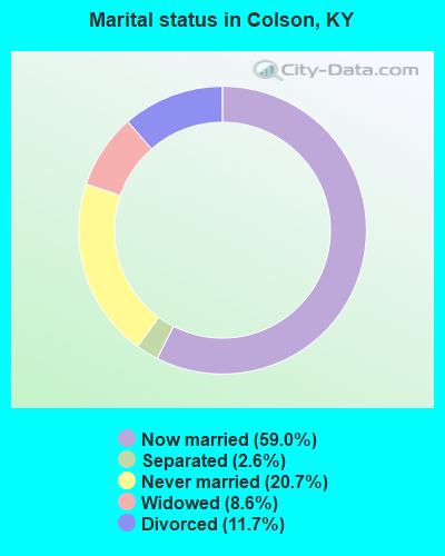
- Never married: 20.7%
- Now married: 59.0%
- Separated: 2.6%
- Widowed: 8.6%
- Divorced: 11.7%
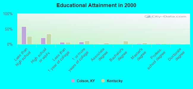
For population 25 years and over in Colson:
- High school or higher: 41.3%
- Bachelor's degree or higher: 4.2%
- Graduate or professional degree: 4.1%
- Unemployed: 27.6%
- Mean travel time to work (commute): 25.3 minutes
| Here: | 20.0 |
| Kentucky average: | 13.8 |
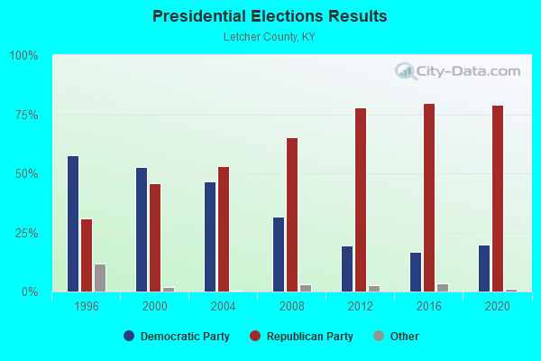
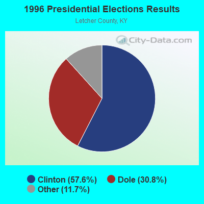
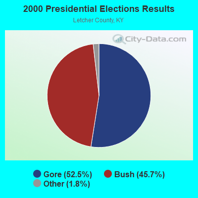
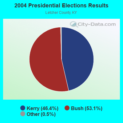
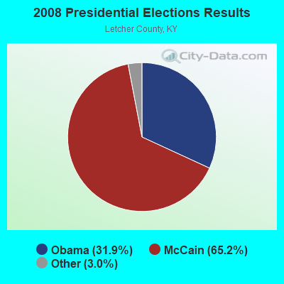

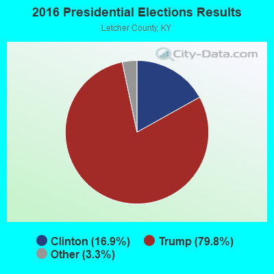
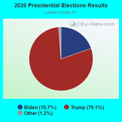
Graphs represent county-level data. Detailed 2008 Election Results
Religion statistics for Colson, KY (based on Letcher County data)
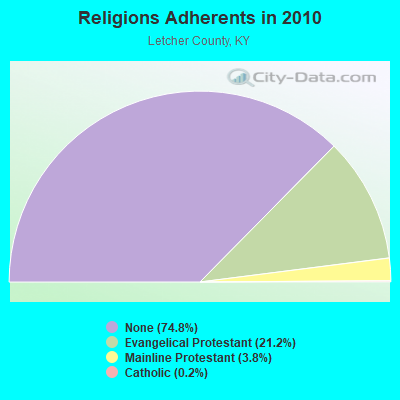
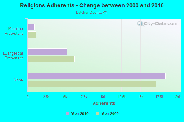
| Religion | Adherents | Congregations |
|---|---|---|
| Evangelical Protestant | 5,210 | 39 |
| Mainline Protestant | 929 | 7 |
| Catholic | 48 | 2 |
| Other | - | 1 |
| None | 18,332 | - |
Food Environment Statistics:
| Here: | 2.92 / 10,000 pop. |
| State: | 2.19 / 10,000 pop. |
| Letcher County: | 0.42 / 10,000 pop. |
| Kentucky: | 0.74 / 10,000 pop. |
| Letcher County: | 1.67 / 10,000 pop. |
| State: | 4.36 / 10,000 pop. |
| Letcher County: | 1.25 / 10,000 pop. |
| Kentucky: | 5.74 / 10,000 pop. |
| Letcher County: | 14.6% |
| Kentucky: | 11.0% |
| Here: | 36.9% |
| Kentucky: | 30.0% |
| This county: | 19.5% |
| State: | 15.9% |
Strongest AM radio stations in Colson:
- WTCW (920 AM; 4 kW; WHITESBURG, KY; Owner: T.C.W. BROADCASTING , INC.)
- WEZC (1480 AM; daytime; 5 kW; NEON, KY; Owner: JESUS COMMUNICATION ILNC.)
- WLSI (900 AM; 5 kW; PIKEVILLE, KY; Owner: EAST KENTUCKY BROADCASTING CORPORATION)
- WKIC (1390 AM; 5 kW; HAZARD, KY)
- WNVA (1350 AM; 5 kW; NORTON, VA; Owner: RADIO-WISE, INC.)
- WKVG (1000 AM; daytime; 1 kW; JENKINS, KY; Owner: MARTINS & ASSOCIATES, INC.)
- WPRT (960 AM; 5 kW; PRESTONSBURG, KY; Owner: EAST KENTUCKY RADIO NETWORK, INC.)
- WDIC (1430 AM; daytime; 5 kW; CLINCHCO, VA; Owner: DICKENSON COUNTY BROADCASTING CORP.)
- WKVL (850 AM; daytime; 50 kW; KNOXVILLE, TN; Owner: HORNE RADIO, LLC)
- WKYH (600 AM; 5 kW; PAINTSVILLE, KY; Owner: HIGHLANDS BROADCASTING CORPORATION)
- WGOC (640 AM; 10 kW; BLOUNTVILLE, TN; Owner: CITADEL BROADCASTING COMPANY)
- WKCB (1340 AM; 1 kW; HINDMAN, KY; Owner: HINDMAN BROADCASTING CORPORATION)
- WBPA (1460 AM; 5 kW; ELKHORN CITY, KY; Owner: EAST KENTUCKY BROADCASTING CORP)
Strongest FM radio stations in Colson:
- WIFX-FM (94.3 FM; JENKINS, KY; Owner: LETCHER COUNTY BROADCASTING, INC)
- WXKQ-FM (103.9 FM; WHITESBURG, KY; Owner: T.C.W. BROADCASTING , INC.)
- WMMT (88.7 FM; WHITESBURG, KY; Owner: APPALSHOP, INCORPORATED)
- WDXC (102.3 FM; POUND, VA; Owner: WDXC RADIO, INC.)
- WWJD (91.7 FM; PIPPA PASSES, KY; Owner: ALICE LLOYD COLLEGE)
- WSEH (102.7 FM; CUMBERLAND, KY; Owner: CUMBERLAND CITY BROADCASTING, INC.)
- WKCB-FM (107.1 FM; HINDMAN, KY; Owner: HINDMAN BROADCASTING CORPORATION)
- WAXM (93.5 FM; BIG STONE GAP, VA; Owner: VALLEY BROADCASTING, INC.)
- WSGS (101.1 FM; HAZARD, KY; Owner: MOUNTAIN BROADCASTING SERVICE, INC.)
- WZQQ (97.9 FM; HYDEN, KY; Owner: LESLIE COUNTY BROADCASTING, INC.)
- WJMD (104.7 FM; HAZARD, KY; Owner: HAZARD BROADCASTING SERVICES)
- WEKH (90.9 FM; HAZARD, KY; Owner: EASTERN KENTUCKY UNIVERSITY)
- WPKE-FM (103.1 FM; COAL RUN, KY; Owner: EAST KENTUCKY BROADCASTING CORP.)
- W223AA (92.5 FM; BIG STONE GAP, VA; Owner: VALLEY BROADCASTING, INC.)
- WZLK (107.5 FM; VIRGIE, KY; Owner: EAST KENTUCKY BROADCASTING CORPORATION)
- WDHR (93.1 FM; PIKEVILLE, KY; Owner: EAST KENTUCKY BROADCASTING CORP.)
- WTFM (98.5 FM; KINGSPORT, TN; Owner: HOLSTON VALLEY BROADCASTING CORP.)
- WXLR (104.9 FM; HAROLD, KY; Owner: ADAM D GEARHEART)
- WNVA-FM (106.3 FM; NORTON, VA; Owner: RADIO WISE, INC.)
- WQHY (95.5 FM; PRESTONSBURG, KY; Owner: WDOC, INC.)
TV broadcast stations around Colson:
- W24BT (Channel 24; TALBERT, KY; Owner: MS COMMUNICATIONS, LLC)
- WYMT-TV (Channel 57; HAZARD, KY; Owner: WYMT LICENSEE CORP.)
- W31BU (Channel 31; TALBERT, KY; Owner: MS COMMUNICATIONS, LLC)
- W53BQ (Channel 53; TALBERT, KY; Owner: MS COMMUNICATIONS, LLC)
- W69ED (Channel 69; TALBERT, KY; Owner: MS COMMUNICATIONS, LLC)
- WKHA (Channel 35; HAZARD, KY; Owner: KENTUCKY AUTHORITY FOR EDUCATIONAL TV)
- W26BK (Channel 26; TALBERT, KY; Owner: MS COMMUNICATIONS, LLC)
- W16BI (Channel 16; TALBERT, KY; Owner: MS COMMUNICATIONS, LLC)
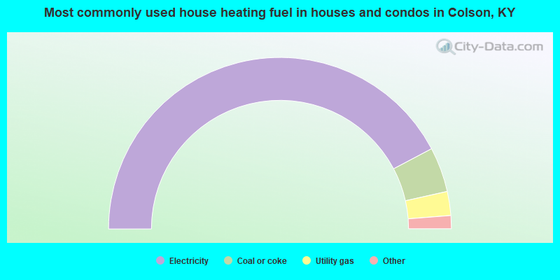
- 84.6%Electricity
- 8.5%Coal or coke
- 4.5%Utility gas
- 1.8%Fuel oil, kerosene, etc.
- 0.7%Wood
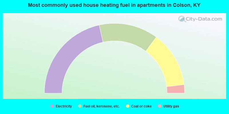
- 43.0%Electricity
- 27.3%Fuel oil, kerosene, etc.
- 25.8%Coal or coke
- 3.9%Utility gas
Colson compared to Kentucky state average:
- Median household income below state average.
- Median house value significantly below state average.
- Unemployed percentage above state average.
- Black race population percentage significantly below state average.
- Hispanic race population percentage significantly below state average.
- Foreign-born population percentage significantly below state average.
- Renting percentage below state average.
- Length of stay since moving in significantly above state average.
- Number of rooms per house significantly below state average.
- House age significantly below state average.
- Percentage of population with a bachelor's degree or higher significantly below state average.