Coast Range, Oregon
Submit your own pictures of this place and show them to the world
- OSM Map
- General Map
- Google Map
- MSN Map

| Males: 4,573 | |
| Females: 4,440 |
| Median resident age: | 37.6 years |
| Oregon median age: | 36.3 years |
Zip code: 97117
| Coast Range: | $106,345 |
| OR: | $75,657 |
Estimated per capita income in 2022: $48,564 (it was $23,656 in 2000)
Coast Range CCD income, earnings, and wages data
Estimated median house or condo value in 2022: $690,907 (it was $211,900 in 2000)
| Coast Range: | $690,907 |
| OR: | $475,600 |
Mean prices in 2022: all housing units: $617,985; detached houses: $663,904; townhouses or other attached units: $422,552; in 2-unit structures: $442,126; in 3-to-4-unit structures: $359,729; in 5-or-more-unit structures: $279,279; mobile homes: $223,774; occupied boats, rvs, vans, etc.: $102,005
Detailed information about poverty and poor residents in Coast Range, OR


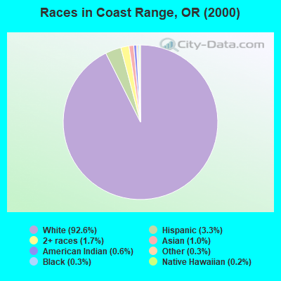
- 7,22492.6%White alone
- 2573.3%Hispanic
- 1291.7%Two or more races
- 791.0%Asian alone
- 490.6%American Indian alone
- 200.3%Black alone
- 270.3%Other race alone
- 130.2%Native Hawaiian and Other
Pacific Islander alone
Races in Coast Range detailed stats: ancestries, foreign born residents, place of birth
 Recent articles from our blog. Our writers, many of them Ph.D. graduates or candidates, create easy-to-read articles on a wide variety of topics.
Current Local Time: PST time zone
Land area: 324.2 square miles.
Population density: 28 people per square mile (very low).

| Coast Range CCD: | 0.8% ($1,737) |
| Oregon: | 1.2% ($1,687) |
Nearest city with pop. 50,000+: Hillsboro, OR  (16.1 miles , pop. 70,186).
Nearest city with pop. 200,000+: Portland, OR (30.3 miles , pop. 529,121).
Nearest city with pop. 1,000,000+: Los Angeles, CA (837.2 miles , pop. 3,694,820).
Nearest cities:
), Latitude: 45.60 N, Longitude: 123.26 W

| Here: | 3.4% |
| Oregon: | 3.9% |
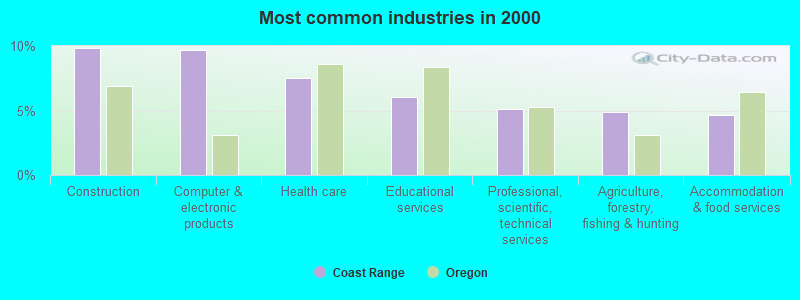
- Construction (9.8%)
- Computer & electronic products (9.7%)
- Health care (7.5%)
- Educational services (6.0%)
- Professional, scientific, technical services (5.1%)
- Agriculture, forestry, fishing & hunting (4.9%)
- Accommodation & food services (4.6%)
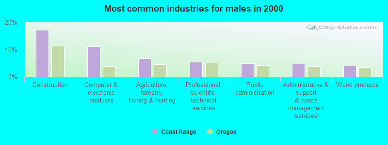
- Construction (17.1%)
- Computer & electronic products (11.2%)
- Agriculture, forestry, fishing & hunting (6.8%)
- Professional, scientific, technical services (5.4%)
- Public administration (5.0%)
- Administrative & support & waste management services (4.8%)
- Wood products (4.1%)
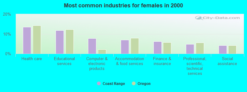
- Health care (13.5%)
- Educational services (11.7%)
- Computer & electronic products (7.8%)
- Accommodation & food services (7.0%)
- Finance & insurance (6.2%)
- Professional, scientific, technical services (4.7%)
- Social assistance (4.2%)
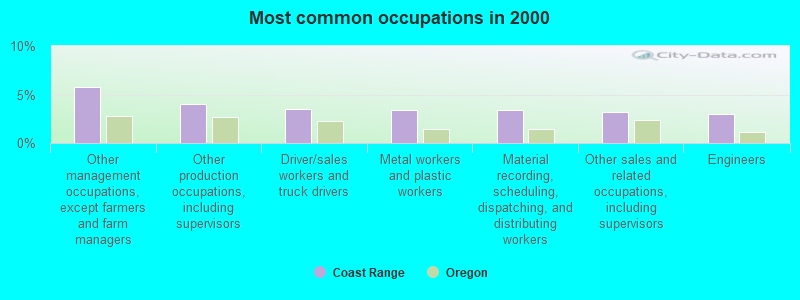
- Other management occupations, except farmers and farm managers (5.7%)
- Other production occupations, including supervisors (4.0%)
- Driver/sales workers and truck drivers (3.5%)
- Metal workers and plastic workers (3.4%)
- Material recording, scheduling, dispatching, and distributing workers (3.4%)
- Other sales and related occupations, including supervisors (3.2%)
- Engineers (2.9%)
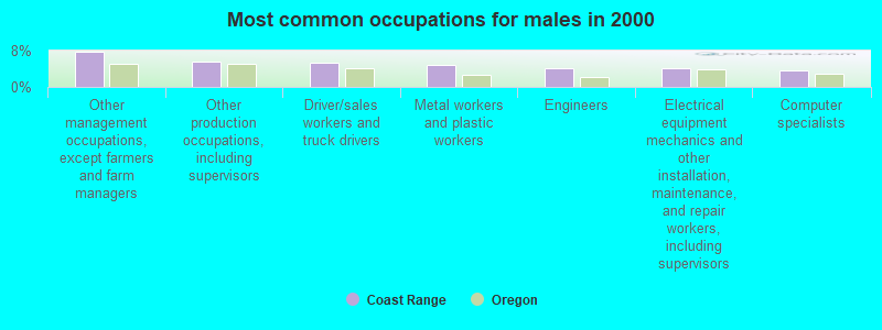
- Other management occupations, except farmers and farm managers (7.9%)
- Other production occupations, including supervisors (5.5%)
- Driver/sales workers and truck drivers (5.2%)
- Metal workers and plastic workers (4.9%)
- Engineers (4.1%)
- Electrical equipment mechanics and other installation, maintenance, and repair workers, including supervisors (4.1%)
- Computer specialists (3.5%)
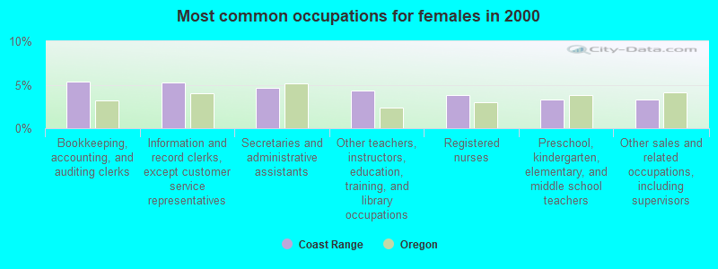
- Bookkeeping, accounting, and auditing clerks (5.4%)
- Information and record clerks, except customer service representatives (5.3%)
- Secretaries and administrative assistants (4.6%)
- Other teachers, instructors, education, training, and library occupations (4.3%)
- Registered nurses (3.8%)
- Preschool, kindergarten, elementary, and middle school teachers (3.3%)
- Other sales and related occupations, including supervisors (3.3%)
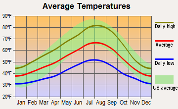
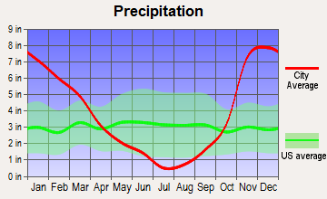
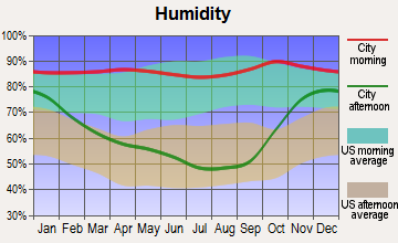
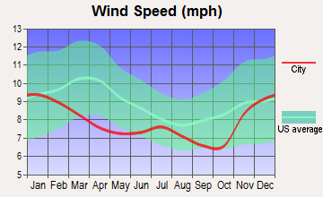
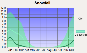
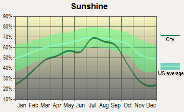
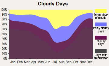
Average climate in Coast Range, Oregon
Based on data reported by over 4,000 weather stations
(lower is better)
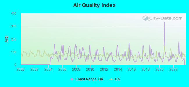
Air Quality Index (AQI) level in 2023 was 55.0. This is better than average.
| City: | 55.0 |
| U.S.: | 72.6 |
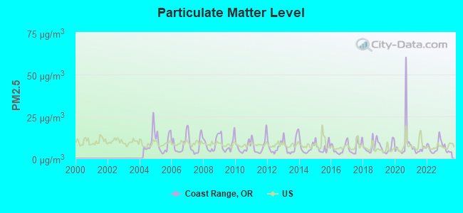
Particulate Matter (PM2.5) [µg/m3] level in 2023 was 4.99. This is significantly better than average. Closest monitor was 14.6 miles away from the city center.
| City: | 4.99 |
| U.S.: | 8.11 |
Earthquake activity:
Coast Range-area historical earthquake activity is significantly above Oregon state average. It is 1404% greater than the overall U.S. average.On 4/13/1949 at 19:55:42, a magnitude 7.0 (7.0 UK, Class: Major, Intensity: VIII - XII) earthquake occurred 119.5 miles away from the city center, causing $80,000,000 total damage
On 2/28/2001 at 18:54:32, a magnitude 6.8 (6.5 MB, 6.6 MS, 6.8 MW, Class: Strong, Intensity: VII - IX) earthquake occurred 107.8 miles away from the city center, causing $2,000,000,000 total damage and $305,000,000 insured losses
On 2/28/2001 at 18:54:32, a magnitude 6.8 (6.8 MD, Depth: 32.2 mi) earthquake occurred 109.9 miles away from the city center
On 4/29/1965 at 15:28:43, a magnitude 6.6 (6.6 UK) earthquake occurred 126.5 miles away from Coast Range center, causing $28,000,000 total damage
On 1/31/1922 at 13:17:28, a magnitude 7.6 (7.6 UK) earthquake occurred 358.3 miles away from the city center
On 8/17/1991 at 22:17:14, a magnitude 7.1 (6.2 MB, 7.1 MS, 7.1 MW, 6.8 ML, Depth: 8.4 mi) earthquake occurred 290.9 miles away from Coast Range center
Magnitude types: body-wave magnitude (MB), duration magnitude (MD), local magnitude (ML), surface-wave magnitude (MS), moment magnitude (MW)
Natural disasters:
The number of natural disasters in Washington County (12) is smaller than the US average (15).Major Disasters (Presidential) Declared: 10
Emergencies Declared: 1
Causes of natural disasters: Floods: 6, Storms: 5, Landslides: 3, Mudslides: 3, Winds: 3, Snows: 2, Winter Storms: 2, Earthquake: 1, Fire: 1, Heavy Rain: 1, Hurricane: 1, Other: 1 (Note: some incidents may be assigned to more than one category).
Hospitals and medical centers near Coast Range:
- LOU-DEL HEALTH CARE CENTER (Nursing Home, about 10 miles away; FOREST GROVE, OR)
- TUALITY HOME HEALTH (Home Health Center, about 10 miles away; FOREST GROVE, OR)
- PNRS RAINES DIALYSIS (Dialysis Facility, about 10 miles away; FOREST GROVE, OR)
- TUALITY FOREST GROVE HOSPITAL (Hospital, about 10 miles away; FOREST GROVE, OR)
- FOREST VIEW CARE CENTER (Nursing Home, about 10 miles away; FOREST GROVE, OR)
- MARQUIS CARE AT FOREST GROVE (Nursing Home, about 10 miles away; FOREST GROVE, OR)
- FOREST GROVE REHABILITATION AND CARE CENTER (Nursing Home, about 11 miles away; FOREST GROVE, OR)
Colleges/universities with over 2000 students nearest to Coast Range:
- Pacific University (about 10 miles; Forest Grove, OR; Full-time enrollment: 2,967)
- George Fox University (about 25 miles; Newberg, OR; FT enrollment: 2,954)
- University of Portland (about 26 miles; Portland, OR; FT enrollment: 4,030)
- Portland Community College (about 28 miles; Portland, OR; FT enrollment: 23,600)
- Portland State University (about 29 miles; Portland, OR; FT enrollment: 21,450)
- Clark College (about 30 miles; Vancouver, WA; FT enrollment: 9,330)
- Concordia University-Portland (about 30 miles; Portland, OR; FT enrollment: 3,996)
Points of interest:
Notable locations in Coast Range: Sunset Speedway (A), Joint Water Commission Cherry Grove Slow Sand Filter Plant (B), Banks Water Treatment Facility (C), Banks Chlorination Plant (D), Stimson Lumber Company Wastewater Treatment Facility (E), Gales Creek Childrens Camp (F), Four Corners (G), Sky Ranch (H), Camp Mountaindale (I), Davies Junction (J), Staleys Junction (K), Strassel (L), Mayo (M), Stimson Mill (N), Scofield (O), Sunset Camp (P), Timber Substation (Q), Tophill (R), Wedeburg (S), Neely Ranch (T). Display/hide their locations on the map
Shopping Center: Oak Village Shopping Center (1). Display/hide its location on the map
Churches in Coast Range include: Mountaindale Church (A), Valley Baptist Church (B). Display/hide their locations on the map
Cemeteries: Raffety Cemetery (1), Union Point Cemetery (2), Cherry Grove Cemetery (3), Buxton Cemetery (4), Mount Olive Lutheran Cemetery (5), Gales Creek Cemetery (6), Hayward Cemetery (7). Display/hide their locations on the map
Lakes and reservoirs: Muskrat Pond (A), Stimson Millpond (B), Barney Reservoir (C), Shipley Pool (D), Henry Hagg Lake (E), Cochran Pond (F), Whiteman Pond (G), Dorman Pond (H). Display/hide their locations on the map
Streams, rivers, and creeks: Cummings Creek (A), Garrigus Creek (B), Murtaugh Creek (C), Robinson Creek (D), Sadd Creek (E), Wall Creek (F), Williams Creek (G), Cedar Canyon Creek (H), Hering Creek (I). Display/hide their locations on the map
Parks in Coast Range include: Reehers Camp (1), Killin Wetlands Park (2), L L Stub Stewart State Park (3), Rogers Forest Park (4), Sunset Park (5), Gales Creek Campground (6), Banks-Vernonia State Trail (7), Henry Hagg County Park (8). Display/hide their locations on the map
| This place: | 2.8 people |
| Oregon: | 2.5 people |
| This place: | 78.7% |
| Whole state: | 63.4% |
| This place: | 5.8% |
| Whole state: | 8.0% |
Likely homosexual households (counted as self-reported same-sex unmarried-partner households)
- Lesbian couples: 0.3% of all households
- Gay men: 0.3% of all households
| This place: | 5.6% |
| Whole state: | 11.6% |
| This place: | 1.7% |
| Whole state: | 5.0% |
For population 15 years and over in Coast Range:
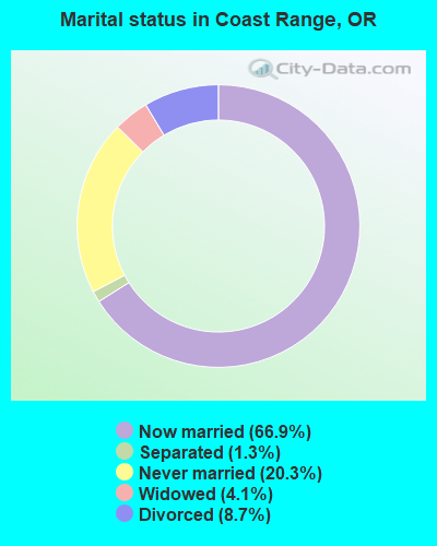
- Never married: 20.3%
- Now married: 66.9%
- Separated: 1.3%
- Widowed: 4.1%
- Divorced: 8.7%
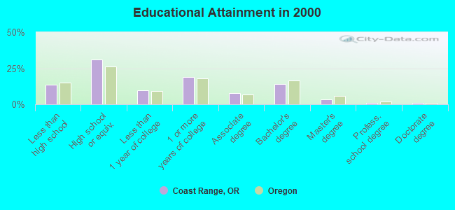
For population 25 years and over in Coast Range:
- High school or higher: 86.6%
- Bachelor's degree or higher: 19.5%
- Graduate or professional degree: 5.4%
- Unemployed: 4.6%
- Mean travel time to work (commute): 31.3 minutes
| Here: | 9.3 |
| Oregon average: | 11.5 |
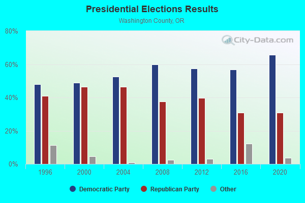
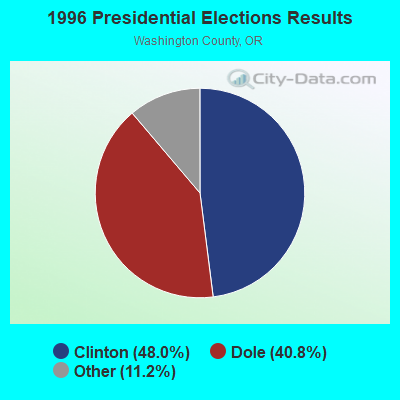
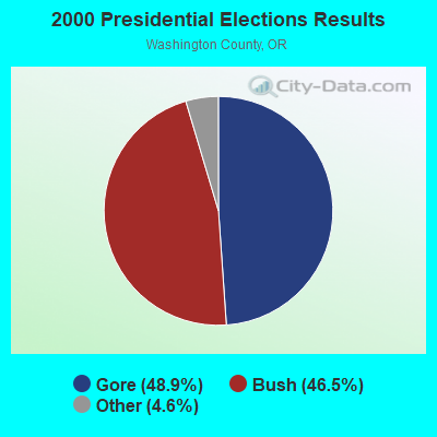
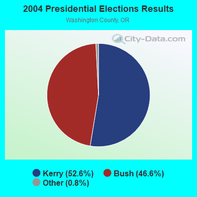
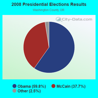
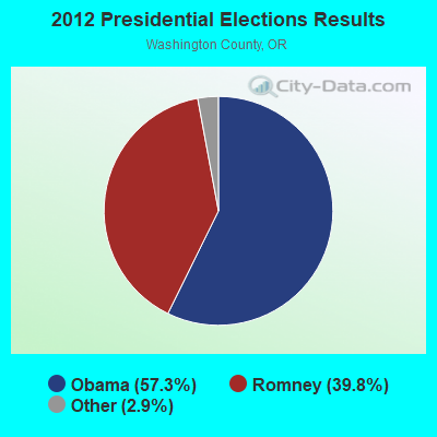
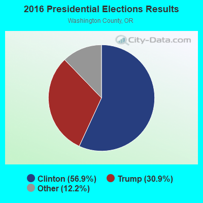
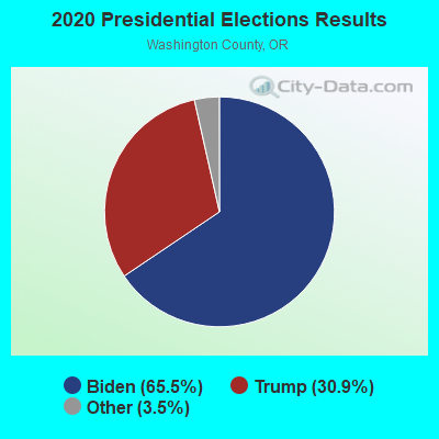
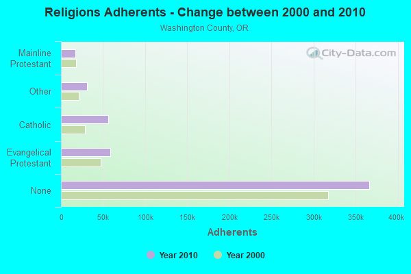
Graphs represent county-level data. Detailed 2008 Election Results
Religion statistics for Coast Range, OR (based on Washington County data)
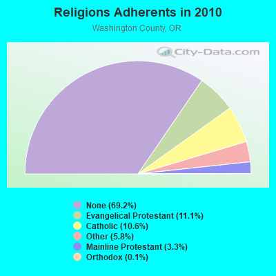
| Religion | Adherents | Congregations |
|---|---|---|
| Evangelical Protestant | 58,752 | 200 |
| Catholic | 55,886 | 11 |
| Other | 30,823 | 77 |
| Mainline Protestant | 17,404 | 53 |
| Orthodox | 550 | 1 |
| None | 366,295 | - |
Food Environment Statistics:
| This county: | 1.44 / 10,000 pop. |
| Oregon: | 2.03 / 10,000 pop. |
| Washington County: | 0.33 / 10,000 pop. |
| Oregon: | 0.33 / 10,000 pop. |
| Here: | 1.42 / 10,000 pop. |
| State: | 2.01 / 10,000 pop. |
| Washington County: | 0.90 / 10,000 pop. |
| Oregon: | 1.69 / 10,000 pop. |
| This county: | 7.35 / 10,000 pop. |
| State: | 9.93 / 10,000 pop. |
| Washington County: | 6.5% |
| Oregon: | 7.4% |
| Washington County: | 24.0% |
| Oregon: | 25.6% |
| Washington County: | 13.8% |
| Oregon: | 14.2% |
8.36% of this county's 2021 resident taxpayers lived in other counties in 2020 ($73,593 average adjusted gross income)
| Here: | 8.36% |
| Oregon average: | 8.20% |
0.01% of residents moved from foreign countries ($84 average AGI)
Washington County: 0.01% Oregon average: 0.01%
Top counties from which taxpayers relocated into this county between 2020 and 2021:
| from Multnomah County, OR | |
| from Clackamas County, OR | |
| from Clark County, WA |
8.64% of this county's 2020 resident taxpayers moved to other counties in 2021 ($92,423 average adjusted gross income)
| Here: | 8.64% |
| Oregon average: | 8.24% |
0.01% of residents moved to foreign countries ($83 average AGI)
Washington County: 0.01% Oregon average: 0.00%
Top counties to which taxpayers relocated from this county between 2020 and 2021:
| to Multnomah County, OR | |
| to Clackamas County, OR | |
| to Clark County, WA |
Strongest AM radio stations in Coast Range:
- KPOJ (620 AM; 50 kW; PORTLAND, OR; Owner: CITICASTERS LICENSES, L.P.)
- KPAM (860 AM; 50 kW; TROUTDALE, OR; Owner: PAMPLIN BROADCASTING-OREGON, INC.)
- KXL (750 AM; 50 kW; PORTLAND, OR; Owner: ROSE CITY RADIO CORPORATION)
- KEX (1190 AM; 50 kW; PORTLAND, OR; Owner: CITICASTERS LICENSES, L.P.)
- KOTK (1080 AM; 50 kW; PORTLAND, OR; Owner: FISHER BROADCASTING - PORTLAND RADIO, L.L.C.)
- KKSN (1520 AM; 50 kW; OREGON CITY, OR; Owner: ENTERCOM PORTLAND LICENSE, LLC)
- KKAD (1550 AM; 50 kW; VANCOUVER, WA; Owner: PAMPLIN BROADCASTING-WASHINGTON, INC)
- KUIK (1360 AM; 5 kW; HILLSBORO, OR; Owner: DOLPHIN COMMUNICATIONS, INC.)
- KFXX (910 AM; 10 kW; VANCOUVER, WA; Owner: ENTERCOM PORTLAND LICENSE, LLC (DE))
- KUPL (970 AM; 5 kW; PORTLAND, OR; Owner: INFINITY RADIO OPERATIONS INC.)
- KKSL (1290 AM; 10 kW; LAKE OSWEGO, OR; Owner: ABC, INC.)
- KDZR (1640 AM; 10 kW; LAKE OSWEGO, OR; Owner: ABC, INC.)
- KKGT (1150 AM; 5 kW; PORTLAND, OR; Owner: WESTERN BROADCASTING COMPANY)
Strongest FM radio stations in Coast Range:
- KINK (101.9 FM; PORTLAND, OR; Owner: INFINITY RADIO OPERATIONS INC.)
- KKCW (103.3 FM; BEAVERTON, OR; Owner: CITICASTERS LICENSES, L.P.)
- KRVO (105.9 FM; VANCOUVER, WA; Owner: CITICASTERS LICENSES, L.P.)
- KPDQ-FM (93.7 FM; PORTLAND, OR; Owner: SALEM MEDIA OF OREGON, INC.)
- KKRZ (100.3 FM; PORTLAND, OR; Owner: CITICASTERS LICENSES, L.P.)
- KOPB-FM (91.5 FM; PORTLAND, OR; Owner: OREGON PUBLIC BROADCASTING)
- KMHD (89.1 FM; GRESHAM, OR; Owner: MT. HOOD COMMUNITY COLLEGE DISTRICT)
- KVMX (107.5 FM; BANKS, OR; Owner: INFINITY RADIO OPERATIONS INC.)
- KLTH (106.7 FM; LAKE OSWEGO, OR; Owner: INIFINITY RADIO OF PORTLAND INC.)
- KUPL-FM (98.7 FM; PORTLAND, OR; Owner: INFINITY RADIO OF PORTLAND INC.)
- K216DH (91.1 FM; CATHLAMET, WA; Owner: TILLICUM FOUNDATION)
- KUFO-FM (101.1 FM; PORTLAND, OR; Owner: INFINITY RADIO OPERATIONS INC.)
- K228DT (93.5 FM; HAPPY HOLLOW, OR; Owner: OREGON PUBLIC BROADCASTING)
- K225AI (92.9 FM; PORTLAND, OR; Owner: EDUCATIONAL MEDIA FOUNDATION)
- KBVM (88.3 FM; PORTLAND, OR; Owner: CATHOLIC BROADCASTING NORTHWEST, INC)
- KBPS-FM (89.9 FM; PORTLAND, OR; Owner: SCHOOL DISTRICT #1, MULTNOMAH COUNTY, OR)
- K273AI (102.5 FM; ARIEL, WA; Owner: CALVARY CHAPEL OF TWIN FALLS, INC.)
- KNRK (94.7 FM; CAMAS, WA; Owner: ENTERCOM PORTLAND LICENSE, LLC (DE))
- KBOO (90.7 FM; PORTLAND, OR; Owner: THE KBOO FOUNDATION)
- KWJJ-FM (99.5 FM; PORTLAND, OR; Owner: FISHER BROADCASTING - PORTLAND RADIO, L.L.C.)
TV broadcast stations around Coast Range:
- KATU (Channel 2; PORTLAND, OR; Owner: FISHER BROADCASTING - PORTLAND TV, L.L.C.)
- KPDX (Channel 49; VANCOUVER, WA; Owner: MEREDITH CORPORATION)
- KPTV (Channel 12; PORTLAND, OR; Owner: MEREDITH CORPORATION)
- K57IF (Channel 57; SALEM, OR; Owner: LaGRANDE BROADCASTING, INC.)
- KOIN (Channel 6; PORTLAND, OR; Owner: EMMIS TELEVISION LICENSE CORPORATION)
- KNMT (Channel 24; PORTLAND, OR; Owner: NATIONAL MINORITY T.V., INC.)
- KGW (Channel 8; PORTLAND, OR; Owner: KING BROADCASTING COMPANY)
- KOPB-TV (Channel 10; PORTLAND, OR; Owner: OREGON PUBLIC BROADCASTING)
- KWBP-LP (Channel 4; PORTLAND, OR; Owner: TRIBUNE BROADCASTING HOLDINGS, INC.)
- KPXG-LP (Channel 54; PORTLAND, OR; Owner: PAXSON COMMUNICATIONS LICENSE COMPANY, LLC)
- K14HN (Channel 14; VANCOUVER/CAMAS, WA; Owner: MEREDITH CORPORATION)
- K18EL (Channel 18; NEWBERG/TIGARD, OR; Owner: MEREDITH CORPORATION)
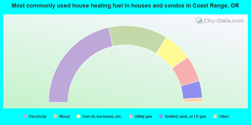
- 42.9%Electricity
- 24.8%Wood
- 12.2%Fuel oil, kerosene, etc.
- 11.0%Utility gas
- 7.2%Bottled, tank, or LP gas
- 1.6%Other fuel
- 0.3%No fuel used
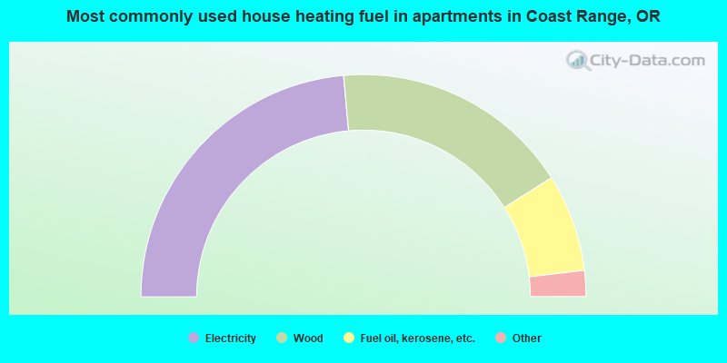
- 47.2%Electricity
- 34.9%Wood
- 14.2%Fuel oil, kerosene, etc.
- 1.9%Utility gas
- 1.9%Bottled, tank, or LP gas
Coast Range compared to Oregon state average:
- Unemployed percentage significantly below state average.
- Black race population percentage significantly below state average.
- Hispanic race population percentage significantly below state average.
- Foreign-born population percentage significantly below state average.
- Renting percentage below state average.
- Length of stay since moving in significantly above state average.
- Number of rooms per house significantly below state average.
- House age significantly below state average.
Coast Range on our top lists:
- #16 on the list of "Top 101 cities with largest percentage of females in occupations: occupational and physical therapist assistants and aides (population 5,000+)"
- #18 on the list of "Top 101 cities with largest percentage of females in industries: computer and electronic products (population 5,000+)"
- #22 on the list of "Top 101 cities with largest percentage of females in occupations: engineers (population 5,000+)"
- #29 on the list of "Top 101 cities with largest percentage of males in industries: computer and electronic products (population 5,000+)"
- #32 on the list of "Top 101 cities with largest percentage of females in industries: building material and garden equipment and supplies dealers (population 5,000+)"
- #39 on the list of "Top 101 cities with largest percentage of females in occupations: driver/sales workers and truck drivers (population 5,000+)"
- #46 on the list of "Top 101 cities with largest percentage of females in occupations: other transportation workers (population 5,000+)"
- #48 on the list of "Top 101 cities with largest percentage of females in occupations: bookkeeping, accounting, and auditing clerks (population 5,000+)"
- #51 on the list of "Top 101 cities with largest percentage of males in industries: wood products (population 5,000+)"
- #53 on the list of "Top 101 cities with largest percentage of males in occupations: other construction workers and helpers (population 5,000+)"
- #66 on the list of "Top 101 cities with largest percentage of males in industries: building material and garden equipment and supplies dealers (population 5,000+)"
- #71 on the list of "Top 101 cities with largest percentage of females in industries: metal and metal products (population 5,000+)"
- #75 on the list of "Top 101 cities with largest percentage of females in industries: lumber and other construction materials merchant wholesalers (population 5,000+)"
- #78 on the list of "Top 101 cities with largest percentage of males in industries: u. s. postal service (population 5,000+)"
- #90 on the list of "Top 101 cities with largest percentage of males in industries: retail florists (population 5,000+)"
- #92 on the list of "Top 101 cities with largest percentage of females in industries: data processing, libraries, and other information services (population 5,000+)"
- #94 on the list of "Top 101 cities with largest percentage of females in industries: plastics and rubber products (population 5,000+)"
- #101 on the list of "Top 101 cities with largest percentage of males in industries: gasoline stations (population 5,000+)"
- #9 on the list of "Top 101 counties with the highest percentage of residents that exercised in the past month"
- #32 on the list of "Top 101 counties with the largest increase in the number of infant deaths per 1000 residents 2000-2006 to 2007-2013 (pop. 50,000+)"
- #42 on the list of "Top 101 counties with the largest number of children under 18 without health insurance coverage in 2000 (pop. 50,000+)"
- #47 on the list of "Top 101 counties with the lowest number of infant deaths per 1000 residents 2007-2013 (pop. 50,000+)"
- #49 on the list of "Top 101 counties with the lowest percentage of residents that smoked 100+ cigarettes in their lives"