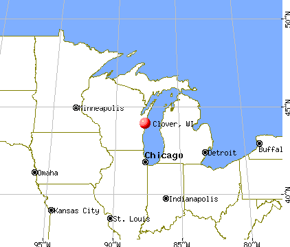
Clover, Wisconsin
Submit your own pictures of this town and show them to the world
- OSM Map
- General Map
- Google Map
- MSN Map

Population change since 2000: +5.7%
 |
| Males: 125 | |
| Females: 98 |
| Median resident age: | 57.7 years |
| Wisconsin median age: | 42.6 years |
Zip codes: 54844.
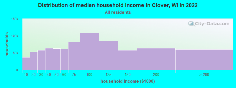
| Clover: | $55,023 |
| WI: | $70,996 |
Estimated per capita income in 2022: $36,973 (it was $15,355 in 2000)
Clover town income, earnings, and wages data
Estimated median house or condo value in 2022: $253,320 (it was $94,500 in 2000)
| Clover: | $253,320 |
| WI: | $252,800 |
Mean prices in 2022: all housing units: $283,251; detached houses: $295,093; townhouses or other attached units: $452,863; in 2-unit structures: $274,116; in 3-to-4-unit structures: $123,082; in 5-or-more-unit structures: $339,992; mobile homes: $87,640; occupied boats, rvs, vans, etc.: $120,329
Detailed information about poverty and poor residents in Clover, WI


- 21395.5%White alone
- 41.8%Two or more races
- 31.3%Hispanic
- 20.9%American Indian alone
- 10.4%Other race alone

Races in Clover detailed stats: ancestries, foreign born residents, place of birth
 Recent articles from our blog. Our writers, many of them Ph.D. graduates or candidates, create easy-to-read articles on a wide variety of topics.

 | Moving to Milwaukee (4 replies) |
Latest news from Clover, WI collected exclusively by city-data.com from local newspapers, TV, and radio stations
Ancestries: German (27.5%), Swedish (11.8%), Irish (10.9%), English (8.5%), Norwegian (7.1%), Polish (6.6%).
Current Local Time: CST time zone
Elevation: 671 feet
Land area: 59.6 square miles.
Population density: 3.7 people per square mile (very low).
3 residents are foreign born
| This town: | 1.4% |
| Wisconsin: | 3.6% |
| Clover town: | 1.8% ($1,688) |
| Wisconsin: | 2.0% ($2,245) |
Nearest city with pop. 50,000+: Duluth, MN  (41.6 miles , pop. 86,918).
Nearest city with pop. 200,000+: St. Paul, MN (155.6 miles , pop. 287,151).
Nearest city with pop. 1,000,000+: Chicago, IL (384.6 miles , pop. 2,896,016).
Nearest cities:
), ), ), )Latitude: 46.79 N, Longitude: 91.24 W
Area code commonly used in this area: 715

| Here: | 4.8% |
| Wisconsin: | 2.7% |

- Educational services (13.8%)
- Construction (12.6%)
- Building material & garden equipment & supplies dealers (12.6%)
- Agriculture, forestry, fishing & hunting (11.5%)
- Health care (10.3%)
- Accommodation & food services (9.2%)
- Lumber & other construction materials merchant wholesalers (4.6%)

- Construction (22.4%)
- Building material & garden equipment & supplies dealers (16.3%)
- Agriculture, forestry, fishing & hunting (12.2%)
- Lumber & other construction materials merchant wholesalers (8.2%)
- Paper (6.1%)
- Other transportation, support activities, couriers (6.1%)
- Educational services (6.1%)

- Educational services (23.7%)
- Health care (18.4%)
- Accommodation & food services (13.2%)
- Agriculture, forestry, fishing & hunting (10.5%)
- Building material & garden equipment & supplies dealers (7.9%)
- Groceries & related products merchant wholesalers (5.3%)
- Department & other general merchandise stores (5.3%)

- Cooks and food preparation workers (9.2%)
- Farmers and farm managers (9.2%)
- Other sales and related occupations, including supervisors (9.2%)
- Woodworkers (8.0%)
- Carpenters (6.9%)
- Secretaries and administrative assistants (5.7%)
- Registered nurses (5.7%)

- Farmers and farm managers (12.2%)
- Other sales and related occupations, including supervisors (12.2%)
- Carpenters (12.2%)
- Woodworkers (10.2%)
- Driver/sales workers and truck drivers (8.2%)
- Cooks and food preparation workers (6.1%)
- Teachers, secondary school (6.1%)

- Registered nurses (13.2%)
- Cooks and food preparation workers (13.2%)
- Secretaries and administrative assistants (13.2%)
- Preschool, kindergarten, elementary, and middle school teachers (7.9%)
- Information and record clerks, except customer service representatives (5.3%)
- Operations specialties managers, except financial managers (5.3%)
- Farmers and farm managers (5.3%)
Average climate in Clover, Wisconsin
Based on data reported by over 4,000 weather stations


Earthquake activity:
Clover-area historical earthquake activity is significantly above Wisconsin state average. It is 71% smaller than the overall U.S. average.On 7/9/1975 at 14:54:15, a magnitude 4.6 (4.6 MB, Class: Light, Intensity: IV - V) earthquake occurred 242.4 miles away from the city center
On 2/7/2020 at 18:30:28, a magnitude 3.3 (3.3 ML, Class: Light, Intensity: II - III) earthquake occurred 84.8 miles away from the city center
On 4/8/2020 at 17:14:33, a magnitude 3.3 (3.3 ML) earthquake occurred 85.5 miles away from Clover center
On 1/9/2020 at 18:16:48, a magnitude 3.3 (3.3 MB) earthquake occurred 85.9 miles away from Clover center
On 3/2/2017 at 16:53:31, a magnitude 3.2 (3.2 ML) earthquake occurred 67.6 miles away from the city center
On 4/24/2020 at 17:23:43, a magnitude 3.2 (3.2 ML) earthquake occurred 79.5 miles away from the city center
Magnitude types: body-wave magnitude (MB), local magnitude (ML)
Natural disasters:
The number of natural disasters in Bayfield County (10) is smaller than the US average (15).Major Disasters (Presidential) Declared: 8
Emergencies Declared: 2
Causes of natural disasters: Floods: 7, Storms: 5, Winds: 2, Drought: 1, Heavy Rain: 1, Hurricane: 1, Mudslide: 1, Other: 1 (Note: some incidents may be assigned to more than one category).
Colleges/universities with over 2000 students nearest to Clover:
- University of Minnesota-Duluth (about 41 miles; Duluth, MN; Full-time enrollment: 10,612)
- University of Wisconsin-Superior (about 41 miles; Superior, WI; FT enrollment: 2,302)
- The College of Saint Scholastica (about 42 miles; Duluth, MN; FT enrollment: 3,762)
- Lake Superior College (about 43 miles; Duluth, MN; FT enrollment: 3,768)
- Wisconsin Indianhead Technical College (about 79 miles; Shell Lake, WI; FT enrollment: 2,414)
- Michigan Technological University (about 130 miles; Houghton, MI; FT enrollment: 6,078)
- University of Wisconsin-Stout (about 136 miles; Menomonie, WI; FT enrollment: 8,120)
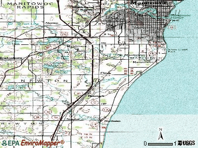
Points of interest:
Notable locations in Clover: Cranberry River State Fishery Area (A), South Shore Area Ambulance Service (B), Herbster Volunteer Fire Department (C). Display/hide their locations on the map
Cemetery: Herbster Cemetery (1). Display/hide its location on the map
Lake: Lake Lenawee (A). Display/hide its location on the map
Rivers and creeks: Lenawee Creek (A), Cranberry River (B). Display/hide their locations on the map
Parks in Clover include: Bark Bay Slough State Natural Area (1), Flag River State Wildlife Area (2). Display/hide their locations on the map
| This town: | 1.9 people |
| Wisconsin: | 2.4 people |
| This town: | 59.5% |
| Whole state: | 64.4% |
| This town: | 7.8% |
| Whole state: | 7.3% |
Likely homosexual households (counted as self-reported same-sex unmarried-partner households)
- Lesbian couples: 0.9% of all households
- Gay men: 0.0% of all households
| This town: | 13.6% |
| Whole state: | 8.7% |
| This town: | 1.9% |
| Whole state: | 3.7% |
For population 15 years and over in Clover:

- Never married: 15.5%
- Now married: 49.4%
- Separated: 1.2%
- Widowed: 8.9%
- Divorced: 25.0%
For population 25 years and over in Clover:
- High school or higher: 85.5%
- Bachelor's degree or higher: 18.7%
- Graduate or professional degree: 7.8%
- Unemployed: 12.1%
- Mean travel time to work (commute): 22.4 minutes


| Here: | 8.8 |
| Wisconsin average: | 11.0 |
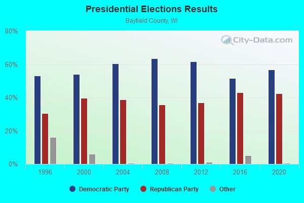
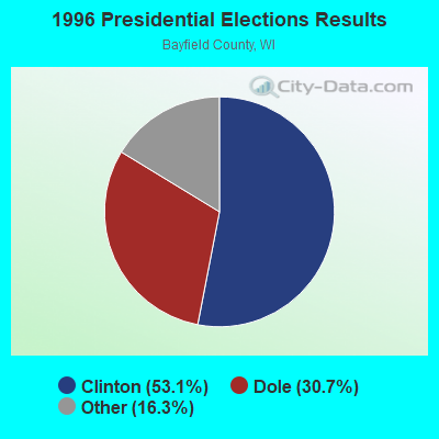
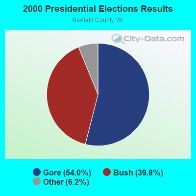
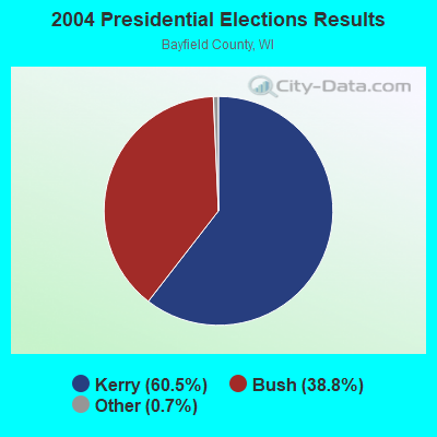
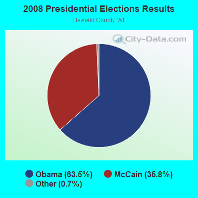
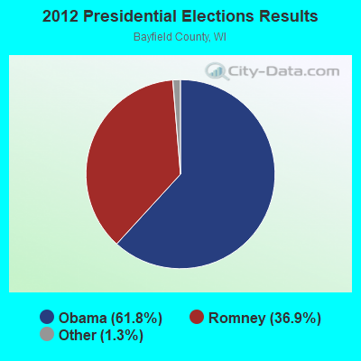
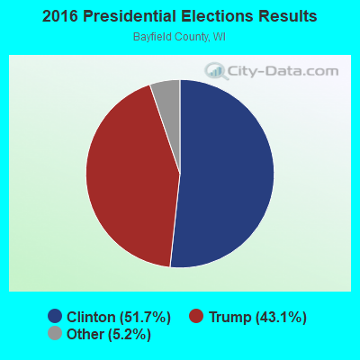
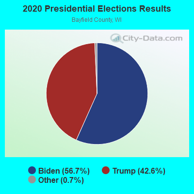
Graphs represent county-level data. Detailed 2008 Election Results
Religion statistics for Clover, WI (based on Bayfield County data)
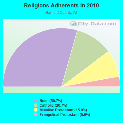
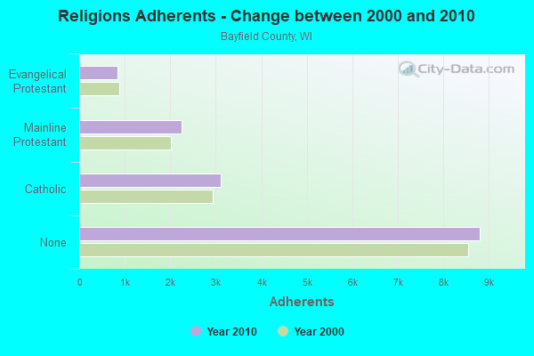
| Religion | Adherents | Congregations |
|---|---|---|
| Catholic | 3,109 | 10 |
| Mainline Protestant | 2,247 | 14 |
| Evangelical Protestant | 847 | 10 |
| Other | 1 | 1 |
| Orthodox | - | - |
| None | 8,810 | - |
Food Environment Statistics:
| Bayfield County: | 3.32 / 10,000 pop. |
| Wisconsin: | 1.86 / 10,000 pop. |
| Here: | 8.63 / 10,000 pop. |
| State: | 4.12 / 10,000 pop. |
| This county: | 26.56 / 10,000 pop. |
| Wisconsin: | 8.64 / 10,000 pop. |
| This county: | 8.7% |
| State: | 7.6% |
| This county: | 27.6% |
| Wisconsin: | 27.5% |
| Bayfield County: | 14.3% |
| Wisconsin: | 13.0% |
Strongest AM radio stations in Clover:
- WEBC (560 AM; 50 kW; DULUTH, MN)
- WDSM (710 AM; 10 kW; SUPERIOR, WI; Owner: MIDWEST COMMUNICATIONS, INC.)
- WWJC (850 AM; daytime; 10 kW; DULUTH, MN; Owner: WWJC, INC.)
- KDAL (610 AM; 5 kW; DULUTH, MN; Owner: MIDWEST COMMUNICATIONS, INC.)
- WJMS (590 AM; 5 kW; IRONWOOD, MI; Owner: ROBERTS BROADCASTING, INC.)
- WCCO (830 AM; 50 kW; MINNEAPOLIS, MN; Owner: INFINITY MEDIA CORPORATION)
- WCTS (1030 AM; 50 kW; MAPLEWOOD, MN; Owner: CNTL. BAPT. THEO/AL SEMI MINNEAPOLIS)
- WNMT (650 AM; 10 kW; NASHWAUK, MN; Owner: MIDWEST RADIO NETWORK, L.L.C.)
- WHSM (910 AM; 5 kW; HAYWARD, WI; Owner: QB BROADCASTING, LTD.)
- WSPT (1010 AM; 50 kW; STEVENS POINT, WI)
- KSTP (1500 AM; 50 kW; ST. PAUL, MN; Owner: KSTP-AM, LLC (DELAWARE))
- WSAU (550 AM; 20 kW; WAUSAU, WI; Owner: WRIG, INC.)
- KFAN (1130 AM; 50 kW; MINNEAPOLIS, MN; Owner: AMFM RADIO LICENSES, L.L.C.)
Strongest FM radio stations in Clover:
- WEGZ (105.9 FM; WASHBURN, WI; Owner: KEWEENAW BAY BROADCASTING, INC.)
- WNXR (107.3 FM; IRON RIVER, WI; Owner: GERALD J. HACKMAN)
- WHSA (89.9 FM; BRULE, WI; Owner: STATE OF WISCONSIN - EDUCATIONAL COMMUNICATIONS BOARD)
- KBMX (107.7 FM; PROCTOR, MN; Owner: REGENT BROADCASTING OF DULUTH, INC.)
- WWAX (92.1 FM; HERMANTOWN, MN; Owner: RED ROCK RADIO CORP.)
- WJJH (96.7 FM; ASHLAND, WI; Owner: BAY BROADCASTING CORPORATION)
- WSCN (100.5 FM; CLOQUET, MN; Owner: MINNESOTA PUBLIC RADIO)
TV broadcast stations around Clover:
- WDIO-TV (Channel 10; DULUTH, MN; Owner: WDIO-TV, LLC)
- WAST-LP (Channel 25; ASHLAND, WI; Owner: RESOURCE RECOVERY OF WISCONSIN, INC.)
- National Bridge Inventory (NBI) Statistics
- 4Number of bridges
- 20ft / 5.7mTotal length
- 253Total average daily traffic
- 6Total average daily truck traffic
- 276Total future (year 2039) average daily traffic
FCC Registered Antenna Towers:
2- Wayne S Reese, 3722 Carstens Lake Road (Lat: 44.026111 Lon: -87.692889), Type: 106.1, Overall height: 105.2 m, Registrant: Midwest Communications, Inc., Tim.Laes@mwcradio.Com, , Wausa-u, Phone: (715) 842-1437
- John S Neely, 3722 Carstens Lake Road (Lat: 44.026111 Lon: -87.692889), Type: 106.1, Structure height: 55071 m, Overall height: 105.2 m, Registrant: Midwest Communications, Inc., Tim.Laes@mwcradio.Com, , Wausa-u, Phone: (715) 842-1437

- 57.1%Bottled, tank, or LP gas
- 17.6%Fuel oil, kerosene, etc.
- 16.5%Wood
- 8.8%Electricity

- 77.8%Bottled, tank, or LP gas
- 22.2%Fuel oil, kerosene, etc.
Clover compared to Wisconsin state average:
- Black race population percentage significantly below state average.
- Hispanic race population percentage significantly below state average.
- Median age significantly above state average.
- Foreign-born population percentage significantly below state average.
- Renting percentage significantly below state average.
- Length of stay since moving in significantly above state average.
- Number of rooms per house significantly below state average.
- House age significantly below state average.
- Number of college students significantly below state average.