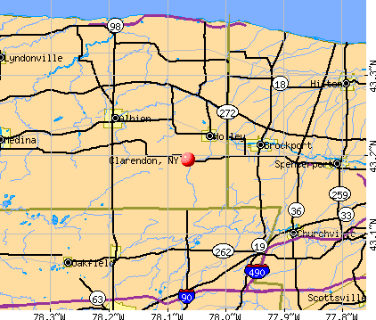
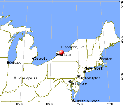
Clarendon, New York
Submit your own pictures of this town and show them to the world
- OSM Map
- General Map
- Google Map
- MSN Map
Population change since 2000: +7.5%
 |
| Males: 1,781 | |
| Females: 1,867 |
| Median resident age: | 43.2 years |
| New York median age: | 40.7 years |
Zip codes: 14470.
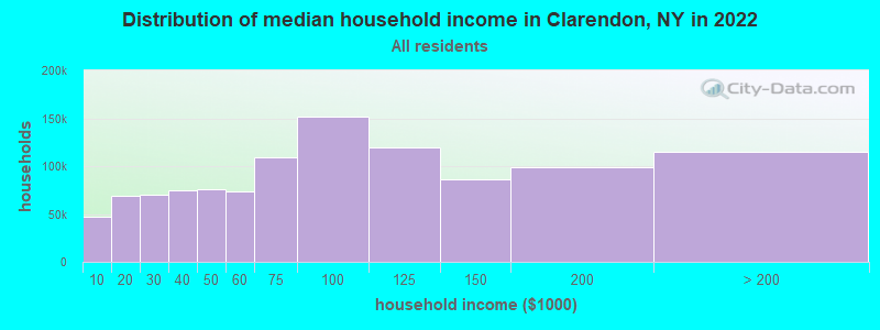
| Clarendon: | $73,366 |
| NY: | $79,557 |
Estimated per capita income in 2022: $37,460 (it was $18,553 in 2000)
Clarendon town income, earnings, and wages data
Estimated median house or condo value in 2022: $139,766 (it was $77,900 in 2000)
| Clarendon: | $139,766 |
| NY: | $400,400 |
Mean prices in 2022: all housing units: $164,365; detached houses: $165,013; townhouses or other attached units: $491,930; in 2-unit structures: $156,438; in 3-to-4-unit structures: $131,294; in 5-or-more-unit structures: $274,444; mobile homes: $57,995
Detailed information about poverty and poor residents in Clarendon, NY


- 3,48495.5%White alone
- 832.3%Hispanic
- 340.9%Black alone
- 220.6%Two or more races
- 140.4%Asian alone
- 110.3%American Indian alone

Races in Clarendon detailed stats: ancestries, foreign born residents, place of birth
 Recent articles from our blog. Our writers, many of them Ph.D. graduates or candidates, create easy-to-read articles on a wide variety of topics.

 | smaller Upstate NY cities and towns/African American communities (5974 replies) |
| Best Apartment Complexes in the Syracuse, NY Area (6 replies) |
| Narrowest Townhouse In NYC for sale, about 10 ft wide, for about $5M (20 replies) |
| How Bad Is Fare Evasion? One Rider Per Minute (55 replies) |
| East Flatbush: Is up and coming? (119 replies) |
| Million Dollar Homes becoming more common in Brooklyn (22 replies) |
Latest news from Clarendon, NY collected exclusively by city-data.com from local newspapers, TV, and radio stations
Ancestries: German (23.7%), Irish (21.3%), English (20.0%), Italian (12.9%), United States (6.8%), Polish (5.6%).
Current Local Time: EST time zone
Elevation: 600 feet
Land area: 35.2 square miles.
Population density: 104 people per square mile (very low).
14 residents are foreign born
| This town: | 0.4% |
| New York: | 20.4% |
| Clarendon town: | 3.2% ($2,526) |
| New York: | 1.9% ($2,847) |
Nearest city with pop. 50,000+: Rochester, NY  (22.3 miles , pop. 219,773).
Nearest city with pop. 1,000,000+: Philadelphia, PA (266.3 miles , pop. 1,517,550).
Nearest cities:
), ), Latitude: 43.17 N, Longitude: 78.05 W
Area code commonly used in this area: 585

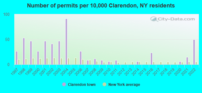
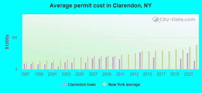
Single-family new house construction building permits:
- 2022: 17 buildings, average cost: $138,200
- 2021: 5 buildings, average cost: $257,500
- 2020: 2 buildings, average cost: $172,500
- 2016: 8 buildings, average cost: $190,600
- 2014: 2 buildings, average cost: $275,000
- 2011: 3 buildings, average cost: $166,700
- 2010: 2 buildings, average cost: $200,000
- 2009: 3 buildings, average cost: $193,300
- 2008: 4 buildings, average cost: $172,500
- 2007: 3 buildings, average cost: $176,700
- 2006: 9 buildings, average cost: $113,900
- 2004: 31 buildings, average cost: $110,300
- 2003: 16 buildings, average cost: $109,700
- 2002: 14 buildings, average cost: $50,000
- 2001: 16 buildings, average cost: $105,500
- 2000: 9 buildings, average cost: $84,300
- 1999: 16 buildings, average cost: $82,000
- 1998: 18 buildings, average cost: $88,300
- 1997: 9 buildings, average cost: $94,000
| Here: | 4.6% |
| New York: | 4.4% |
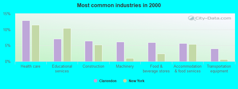
- Health care (12.9%)
- Educational services (7.1%)
- Construction (6.4%)
- Machinery (6.1%)
- Food & beverage stores (5.9%)
- Accommodation & food services (5.7%)
- Transportation equipment (4.0%)
- Machinery (11.2%)
- Construction (11.2%)
- Food & beverage stores (6.6%)
- Transportation equipment (5.9%)
- Accommodation & food services (4.9%)
- Metal & metal products (4.9%)
- Educational services (4.0%)
- Health care (23.1%)
- Educational services (10.3%)
- Accommodation & food services (6.5%)
- Food & beverage stores (5.2%)
- Social assistance (4.9%)
- Professional, scientific, technical services (4.6%)
- Used merchandise, gift, novelty, souvenir, other miscellaneous stores (4.4%)
- Other production occupations, including supervisors (5.1%)
- Driver/sales workers and truck drivers (4.5%)
- Metal workers and plastic workers (4.4%)
- Computer specialists (4.4%)
- Nursing, psychiatric, and home health aides (3.7%)
- Health technologists and technicians (3.5%)
- Registered nurses (3.4%)
- Driver/sales workers and truck drivers (8.9%)
- Other production occupations, including supervisors (8.7%)
- Metal workers and plastic workers (7.4%)
- Computer specialists (6.1%)
- Other management occupations, except farmers and farm managers (5.7%)
- Retail sales workers, except cashiers (5.1%)
- Vehicle and mobile equipment mechanics, installers, and repairers (4.6%)

- Health technologists and technicians (7.2%)
- Registered nurses (7.0%)
- Nursing, psychiatric, and home health aides (6.5%)
- Cashiers (5.2%)
- Assemblers and fabricators (4.3%)
- Waiters and waitresses (4.0%)
- Child care workers (4.0%)
Average climate in Clarendon, New York
Based on data reported by over 4,000 weather stations


Earthquake activity:
Clarendon-area historical earthquake activity is significantly above New York state average. It is 68% smaller than the overall U.S. average.On 9/25/1998 at 19:52:52, a magnitude 5.2 (4.8 MB, 4.3 MS, 5.2 LG, 4.5 MW, Depth: 3.1 mi, Class: Moderate, Intensity: VI - VII) earthquake occurred 167.0 miles away from Clarendon center
On 10/7/1983 at 10:18:46, a magnitude 5.3 (5.1 MB, 5.3 LG, 5.1 ML) earthquake occurred 193.7 miles away from Clarendon center
On 4/20/2002 at 10:50:47, a magnitude 5.3 (5.3 ML, Depth: 3.0 mi) earthquake occurred 236.2 miles away from Clarendon center
On 1/31/1986 at 16:46:43, a magnitude 5.0 (5.0 MB) earthquake occurred 192.3 miles away from the city center
On 4/20/2002 at 10:50:47, a magnitude 5.2 (5.2 MB, 4.2 MS, 5.2 MW, 5.0 MW) earthquake occurred 234.6 miles away from the city center
On 8/23/2011 at 17:51:04, a magnitude 5.8 (5.8 MW, Depth: 3.7 mi) earthquake occurred 364.2 miles away from the city center
Magnitude types: regional Lg-wave magnitude (LG), body-wave magnitude (MB), local magnitude (ML), surface-wave magnitude (MS), moment magnitude (MW)
Natural disasters:
The number of natural disasters in Orleans County (21) is greater than the US average (15).Major Disasters (Presidential) Declared: 10
Emergencies Declared: 9
Causes of natural disasters: Floods: 5, Snowstorms: 5, Storms: 5, Winter Storms: 5, Hurricanes: 2, Blizzard: 1, Ice Storm: 1, Power Outage: 1, Wind: 1, Other: 2 (Note: some incidents may be assigned to more than one category).

Hospitals and medical centers near Clarendon:
- LAKESIDE BEIKIRCH CARE CTR (Nursing Home, about 7 miles away; BROCKPORT, NY)
- LIFETIME ASSISTANCE, INC (Hospital, about 7 miles away; BROCKPORT, NY)
- LAKESIDE MEMORIAL HOSPITAL (Hospital, about 7 miles away; BROCKPORT, NY)
- ARNOLD GREGORY MEMORIAL HOSPITAL (Hospital, about 9 miles away; ALBION, NY)
- HOSPICE OF ORLEANS , INC (Hospital, about 10 miles away; ALBION, NY)
- LIFETIME ASSISTANCE, INC (Hospital, about 11 miles away; CHURCHVILLE, NY)
- WEDGEWOOD NURSING HOME (Nursing Home, about 13 miles away; SPENCERPORT, NY)
Colleges/universities with over 2000 students nearest to Clarendon:
- SUNY College at Brockport (about 6 miles; Brockport, NY; Full-time enrollment: 7,398)
- Genesee Community College (about 12 miles; Batavia, NY; FT enrollment: 4,290)
- Rochester Institute of Technology (about 20 miles; Rochester, NY; FT enrollment: 14,177)
- University of Rochester (about 22 miles; Rochester, NY; FT enrollment: 10,201)
- Monroe Community College (about 24 miles; Rochester, NY; FT enrollment: 14,295)
- Saint John Fisher College (about 28 miles; Rochester, NY; FT enrollment: 3,373)
- Nazareth College (about 28 miles; Rochester, NY; FT enrollment: 2,632)
Points of interest:
Notable locations in Clarendon: Maple Grove Farm (A), Christopher Farm (B), Sixth Day Farm (C), Clarendon Volunteer Fire Company (D). Display/hide their locations on the map
Churches in Clarendon include: Disciples United Methodist Church (A), Old Paths Baptist Church (B). Display/hide their locations on the map
Cemeteries: Robinson Burying Ground (1), Glidden Burying Ground (2), Root Cemetery (3), Hillside Cemetery (4), Manning Cemetery (5), Holy Cross Cemetery (6), Maplewood Cemetery (7). Display/hide their locations on the map
Birthplace of: Carl Akeley - Taxidermist.
Drinking water stations with addresses in Clarendon and their reported violations in the past:
CLARENDON TOWN WDS (Population served: 2,482, Purch surface water):Past monitoring violations:
- Monitoring and Reporting (DBP) - Between OCT-2012 and DEC-2012, Contaminant: Total Haloacetic Acids (HAA5). Follow-up actions: St Public Notif requested (DEC-20-2012), St Formal NOV issued (DEC-20-2012), St Compliance achieved (FEB-15-2013)
- Monitoring and Reporting (DBP) - Between OCT-2012 and DEC-2012, Contaminant: TTHM. Follow-up actions: St Public Notif requested (DEC-20-2012), St Formal NOV issued (DEC-20-2012), St Compliance achieved (FEB-15-2013)
| This town: | 2.6 people |
| New York: | 2.6 people |
| This town: | 74.6% |
| Whole state: | 63.5% |
| This town: | 9.0% |
| Whole state: | 6.8% |
Likely homosexual households (counted as self-reported same-sex unmarried-partner households)
- Lesbian couples: 0.4% of all households
- Gay men: 0.1% of all households
| This town: | 8.1% |
| Whole state: | 14.6% |
| This town: | 5.8% |
| Whole state: | 7.4% |
For population 15 years and over in Clarendon:
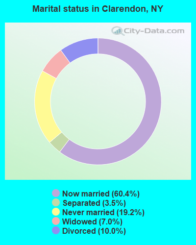
- Never married: 19.2%
- Now married: 60.4%
- Separated: 3.5%
- Widowed: 7.0%
- Divorced: 10.0%
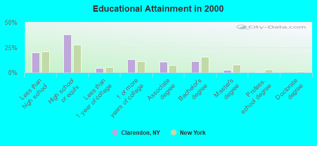
For population 25 years and over in Clarendon:
- High school or higher: 80.1%
- Bachelor's degree or higher: 13.8%
- Graduate or professional degree: 2.6%
- Unemployed: 4.5%
- Mean travel time to work (commute): 32.1 minutes
| Here: | 9.9 |
| New York average: | 14.2 |
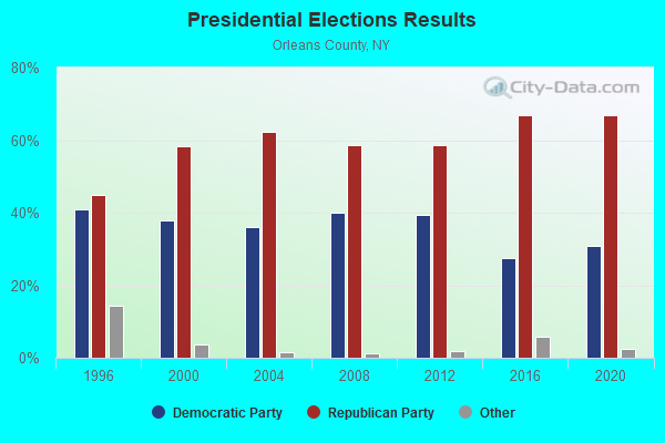
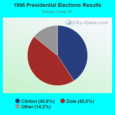
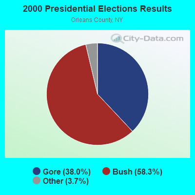
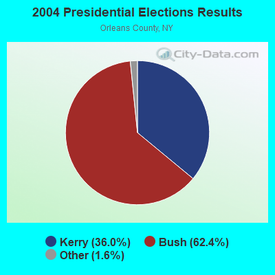
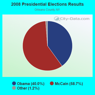
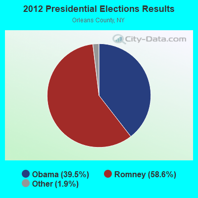
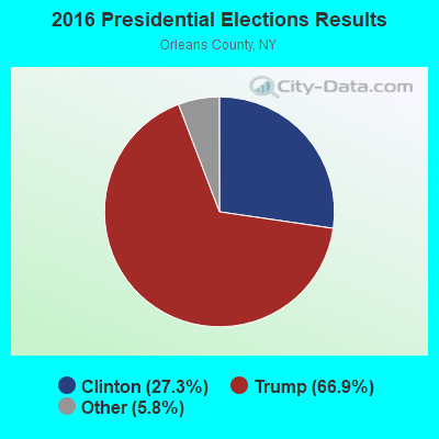
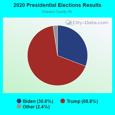
Graphs represent county-level data. Detailed 2008 Election Results
Religion statistics for Clarendon, NY (based on Orleans County data)
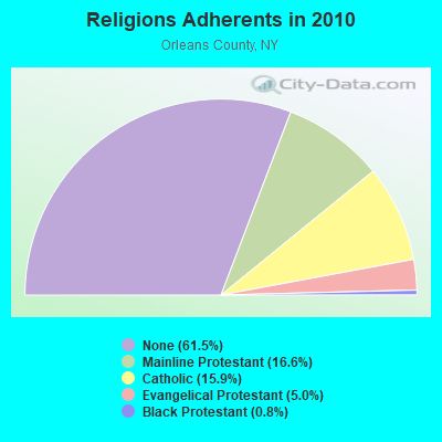
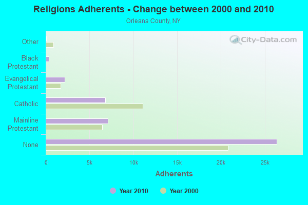
| Religion | Adherents | Congregations |
|---|---|---|
| Mainline Protestant | 7,118 | 27 |
| Catholic | 6,819 | 4 |
| Evangelical Protestant | 2,163 | 21 |
| Black Protestant | 359 | 3 |
| Other | 32 | 2 |
| None | 26,392 | - |
Food Environment Statistics:
| This county: | 2.13 / 10,000 pop. |
| New York: | 4.13 / 10,000 pop. |
| Orleans County: | 4.73 / 10,000 pop. |
| State: | 1.68 / 10,000 pop. |
| This county: | 5.20 / 10,000 pop. |
| State: | 8.82 / 10,000 pop. |
| Here: | 9.5% |
| State: | 8.2% |
| Orleans County: | 26.2% |
| State: | 23.8% |
| This county: | 17.5% |
| New York: | 15.6% |
Strongest AM radio stations in Clarendon:
- WHAM (1180 AM; 50 kW; ROCHESTER, NY; Owner: CITICASTERS LICENSES, L.P.)
- WLGZ (990 AM; 5 kW; ROCHESTER, NY; Owner: KIMTRON, INC.)
- WASB (1590 AM; 1 kW; BROCKPORT, NY; Owner: DAVID L. WOLFE)
- WWKB (1520 AM; 50 kW; BUFFALO, NY; Owner: ENTERCOM BUFFALO LICENSE, LLC)
- WHTK (1280 AM; 5 kW; ROCHESTER, NY)
- WXXI (1370 AM; 5 kW; ROCHESTER, NY; Owner: WXXI PUBLIC BROADCASTING COUNCIL)
- WHIC (1460 AM; 5 kW; ROCHESTER, NY; Owner: HOLY FAMILY COMMUNICATIONS)
- WTOR (770 AM; daytime; 9 kW; YOUNGSTOWN, NY; Owner: BIRACH BROADCASTING CORPORATION)
- WGR (550 AM; 5 kW; BUFFALO, NY; Owner: ENTERCOM BUFFALO LICENSE, LLC)
- WXRL (1300 AM; 5 kW; LANCASTER, NY; Owner: DOME BROADCASTING, INC.)
- WYSL (1040 AM; 2 kW; AVON, NY; Owner: RADIO LIVINGSTON, LTD)
- WBTA (1490 AM; 1 kW; BATAVIA, NY; Owner: BRO-BEN COMMUNICATIONS, INC.)
- WBEN (930 AM; 5 kW; BUFFALO, NY; Owner: ENTERCOM BUFFALO LICENSE, LLC)
Strongest FM radio stations in Clarendon:
- WMJQ (105.5 FM; BROCKPORT, NY; Owner: CANANDAIGUA BROADCASTING, INC.)
- WBSU (89.1 FM; BROCKPORT, NY; Owner: STATE UNIVERSITY OF NEW YORK)
- WJCA (102.1 FM; ALBION, NY; Owner: CSN INTERNATIONAL)
- WRMM-FM (101.3 FM; ROCHESTER, NY; Owner: INFINITY RADIO OPERATIONS INC.)
- WBZA (98.9 FM; ROCHESTER, NY; Owner: ENTERCOM ROCHESTER LICENSE, LLC.)
- WDCZ-FM (102.7 FM; WEBSTER, NY; Owner: KIMTRON, INC.)
- WDKX (103.9 FM; ROCHESTER, NY; Owner: MONROE COUNTY BROADCASTING CO., LTD.)
- WTSS (102.5 FM; BUFFALO, NY; Owner: ENTERCOM BUFFALO LICENSE, LLC)
- WCOU (88.3 FM; WARSAW, NY; Owner: FAMILY LIFE MINISTRIES, INC.)
- WCIY (88.9 FM; CANANDAIGUA, NY; Owner: FAMILY LIFE MINISTRIES, INC.)
- WCMF-FM (96.5 FM; ROCHESTER, NY; Owner: INFINITY RADIO OPERATIONS INC.)
- WFXF (107.3 FM; SOUTH BRISTOL TOWNSH, NY; Owner: CITICASTERS LICENSES, L.P.)
- WNVE (95.1 FM; HONEOYE FALLS, NY; Owner: CITICASTERS LICENSES, L.P.)
- WXXI-FM (91.5 FM; ROCHESTER, NY; Owner: WXXI PUBLIC BROADCASTING COUNCIL)
- DW208AM (89.5 FM; BATAVIA, NY; Owner: AMERICAN FAMILY ASSOCIATION)
- WGCC-FM (90.7 FM; BATAVIA, NY; Owner: GENESEE COMMUNITY COLLEGE)
- W238AB (95.5 FM; ROCHESTER, NY; Owner: CITICASTERS LICENSES, L.P.)
- WZNE (94.1 FM; BRIGHTON, NY; Owner: INFINITY RADIO OPERATIONS INC.)
- WNSA (107.7 FM; WETHERSFIELD TWNSHP, NY; Owner: ADELPHIA COMMUNICATIONS CORPORATION, DEBTOR-IN-POSSESSION)
- WPXY-FM (97.9 FM; ROCHESTER, NY; Owner: INFINITY RADIO OPERATIONS INC.)
TV broadcast stations around Clarendon:
- WPXJ-TV (Channel 51; BATAVIA, NY; Owner: PAXSON BUFFALO LICENSE, INC.)
- WNYO-TV (Channel 49; BUFFALO, NY; Owner: NEW YORK TELEVISION, INC.)
- WGRZ-TV (Channel 2; BUFFALO, NY; Owner: MULTIMEDIA ENTERTAINMENT, INC.)
- WNED-TV (Channel 17; BUFFALO, NY; Owner: WESTERN NY PUBLIC BROADCASTING ASSOC.)
- WUTV (Channel 29; BUFFALO, NY; Owner: WUTV LICENSEE, LLC)
- WBXO-LP (Channel 15; ROCHESTER, NY; Owner: METRO TV, INC.)
- WNLO (Channel 23; BUFFALO, NY; Owner: WIVB BROADCASTING, LLC)
- WBGT-LP (Channel 40; ROCHESTER, NY; Owner: WBGT, LLC)
- WUHF (Channel 31; ROCHESTER, NY; Owner: WUHF LICENSEE, LLC)
- WOKR (Channel 13; ROCHESTER, NY; Owner: CENTRAL NY NEWS, INC.)
- National Bridge Inventory (NBI) Statistics
- 1Number of bridges
- 7ft / 2.3mTotal length
- $621,000Total costs
- 1,194Total average daily traffic
- 47Total average daily truck traffic
- 1,672Total future (year 2037) average daily traffic
FCC Registered Antenna Towers:
10 (See the full list of FCC Registered Antenna Towers in Clarendon)FCC Registered Broadcast Land Mobile Towers:
1- Fire Dept E Lee Rd (Lat: 43.192833 Lon: -78.063917), Call Sign: KQS738,
Assigned Frequencies: 46.0800 MHz, Grant Date: 08/30/2005, Expiration Date: 11/14/2015, Cancellation Date: 01/16/2016, Registrant: Orleans County Emergency Management, 14064 W. County House Road, Albion, NY 14411, Phone: (585) 589-4414, Fax: (589) 585-7671, Email:
FCC Registered Microwave Towers:
1- Clarendon, 4345 Hindsburg Road (Lat: 43.199972 Lon: -78.108583), Type: Silo, Structure height: 47.2 m, Call Sign: WRVV887,
Assigned Frequencies: 19380.0 MHz, 19380.0 MHz, 19380.0 MHz, 19380.0 MHz, 19380.0 MHz, 19380.0 MHz, 19380.0 MHz, 19380.0 MHz, 19380.0 MHz, 19380.0 MHz, 19380.0 MHz, 19380.0 MHz, Grant Date: 01/11/2023, Expiration Date: 01/11/2033, Certifier: Steven Hubbard, Registrant: Intelpath, Hinsdale, IL 60522, Phone: (312) 841-9188, Email:
FCC Registered Amateur Radio Licenses:
3- Call Sign: K2HYP, Licensee ID: L00961563, Grant Date: 03/11/2015, Expiration Date: 03/21/2025, Certifier: George A Strabel, Registrant: George A Strabel, 16324 Four Section Rd, Clarendon, NY 14429-0008
- Call Sign: KB2BBH, Grant Date: 09/18/1996, Expiration Date: 09/18/2006, Cancellation Date: 09/19/2008, Registrant: Gary F Krieger, 4565 Holley Byron Rd, Clarendon, NY 14429
- Call Sign: KD2AVN, Licensee ID: L01662971, Grant Date: 07/17/2021, Expiration Date: 09/22/2031, Certifier: James A Deyoung, Registrant: James A Deyoung, Clarendon, NY 14429
2002 - 2018 National Fire Incident Reporting System (NFIRS) incidents
- Fire incident types reported to NFIRS in Clarendon, NY
- 6041.7%Structure Fires
- 5538.2%Outside Fires
- 2416.7%Mobile Property/Vehicle Fires
- 53.5%Other
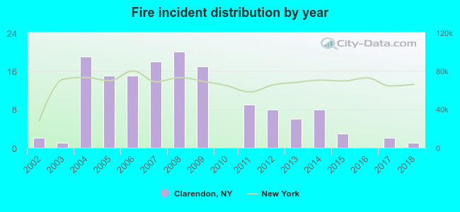 According to the data from the years 2002 - 2018 the average number of fire incidents per year is 8. The highest number of reported fire incidents - 20 took place in 2008, and the least - 0 in 2010. The data has a decreasing trend.
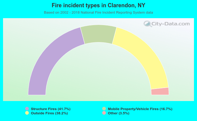 When looking into fire subcategories, the most incidents belonged to: Structure Fires (41.7%), and Outside Fires (38.2%).
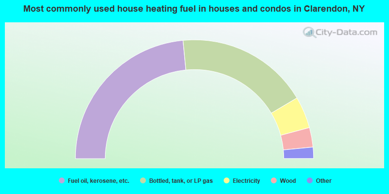
- 46.9%Fuel oil, kerosene, etc.
- 36.0%Bottled, tank, or LP gas
- 8.6%Electricity
- 5.3%Wood
- 1.7%Utility gas
- 1.5%Other fuel
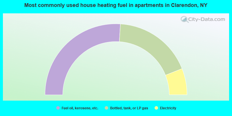
- 52.0%Fuel oil, kerosene, etc.
- 36.0%Bottled, tank, or LP gas
- 12.0%Electricity
Clarendon compared to New York state average:
- Median house value significantly below state average.
- Unemployed percentage significantly below state average.
- Black race population percentage significantly below state average.
- Hispanic race population percentage significantly below state average.
- Foreign-born population percentage significantly below state average.
- Renting percentage significantly below state average.
- Length of stay since moving in significantly above state average.
- Number of rooms per house significantly below state average.
- House age significantly below state average.
- Percentage of population with a bachelor's degree or higher below state average.