Clallam Bay-Neah Bay, Washington
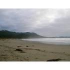
Submit your own pictures of this place and show them to the world
- OSM Map
- Google Map
- MSN Map
| Males: 2,407 | |
| Females: 1,308 |
| Median resident age: | 31.1 years |
| Washington median age: | 35.3 years |
Zip code: 98326
| Clallam Bay-Neah Bay: | $53,844 |
| WA: | $91,306 |
Estimated per capita income in 2022: $32,961 (it was $15,379 in 2000)
Clallam Bay-Neah Bay CCD income, earnings, and wages data
Estimated median house or condo value in 2022: $292,194 (it was $84,800 in 2000)
| Clallam Bay-Neah Bay: | $292,194 |
| WA: | $569,500 |
Mean prices in 2022: all housing units: $459,016; detached houses: $506,716; townhouses or other attached units: $497,618; in 2-unit structures: $248,005; in 3-to-4-unit structures: $251,324; in 5-or-more-unit structures: $440,931; mobile homes: $206,962; occupied boats, rvs, vans, etc.: $91,136
Clallam Bay-Neah Bay, WA residents, houses, and apartments details
Detailed information about poverty and poor residents in Clallam Bay-Neah Bay, WA


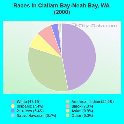
- 1,60047.1%White alone
- 1,12133.0%American Indian alone
- 2517.4%Hispanic
- 2477.3%Black alone
- 1163.4%Two or more races
- 310.9%Asian alone
- 230.7%Native Hawaiian and Other
Pacific Islander alone - 100.3%Other race alone
Races in Clallam Bay-Neah Bay detailed stats: ancestries, foreign born residents, place of birth
 Recent articles from our blog. Our writers, many of them Ph.D. graduates or candidates, create easy-to-read articles on a wide variety of topics.
Current Local Time: PST time zone
Land area: 401.5 square miles.
Population density: 9.3 people per square mile (very low).
| Clallam Bay-Neah Bay CCD: | 1.1% ($974) |
| Washington: | 1.2% ($1,915) |
Nearest city with pop. 50,000+: Bellingham, WA  (99.0 miles , pop. 67,171).
Nearest city with pop. 200,000+: Seattle, WA (108.0 miles , pop. 563,374).
Nearest city with pop. 1,000,000+: Los Angeles, CA (1027.6 miles , pop. 3,694,820).
Nearest cities:
), ), Latitude: 48.23 N, Longitude: 124.48 W
Area code commonly used in this area: 360
| Here: | 6.3% |
| Washington: | 4.6% |
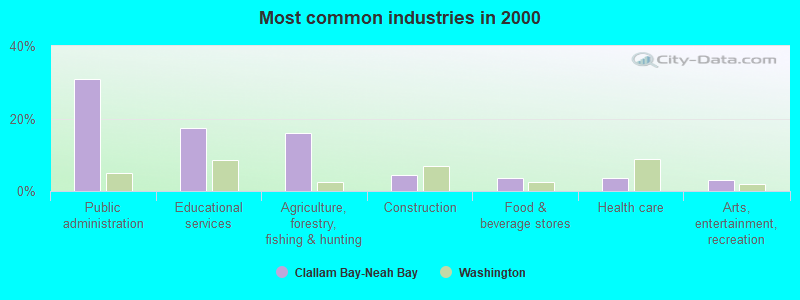
- Public administration (30.9%)
- Educational services (17.4%)
- Agriculture, forestry, fishing & hunting (16.1%)
- Construction (4.5%)
- Food & beverage stores (3.6%)
- Health care (3.6%)
- Arts, entertainment, recreation (2.9%)
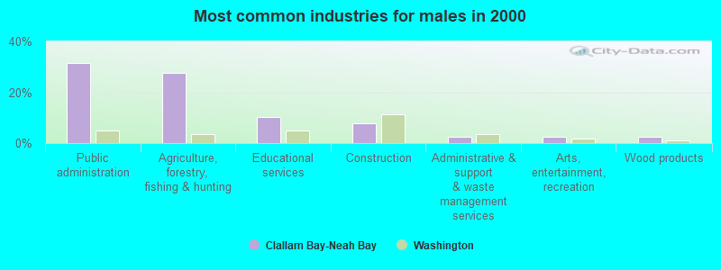
- Public administration (31.4%)
- Agriculture, forestry, fishing & hunting (27.6%)
- Educational services (10.3%)
- Construction (7.9%)
- Administrative & support & waste management services (2.6%)
- Arts, entertainment, recreation (2.6%)
- Wood products (2.4%)
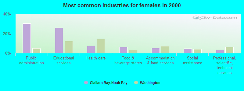
- Public administration (30.2%)
- Educational services (26.0%)
- Health care (7.4%)
- Food & beverage stores (6.2%)
- Accommodation & food services (5.2%)
- Social assistance (4.5%)
- Professional, scientific, technical services (3.3%)
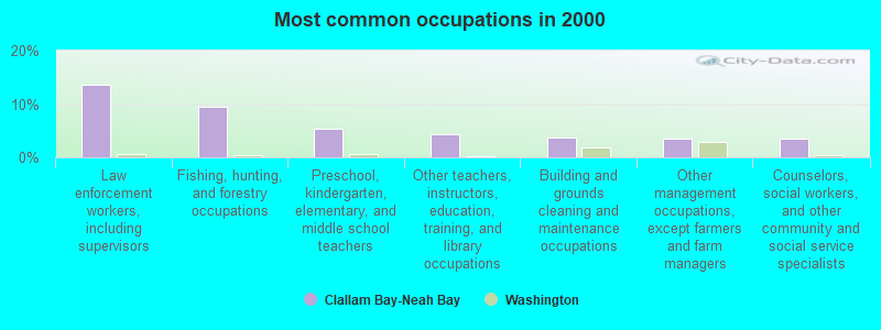
- Law enforcement workers, including supervisors (13.7%)
- Fishing, hunting, and forestry occupations (9.5%)
- Preschool, kindergarten, elementary, and middle school teachers (5.4%)
- Other teachers, instructors, education, training, and library occupations (4.3%)
- Building and grounds cleaning and maintenance occupations (3.7%)
- Other management occupations, except farmers and farm managers (3.6%)
- Counselors, social workers, and other community and social service specialists (3.5%)
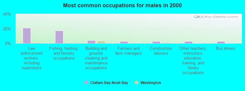
- Law enforcement workers, including supervisors (21.1%)
- Fishing, hunting, and forestry occupations (17.4%)
- Building and grounds cleaning and maintenance occupations (3.9%)
- Farmers and farm managers (3.0%)
- Construction laborers (3.0%)
- Other teachers, instructors, education, training, and library occupations (2.8%)
- Bus drivers (2.8%)
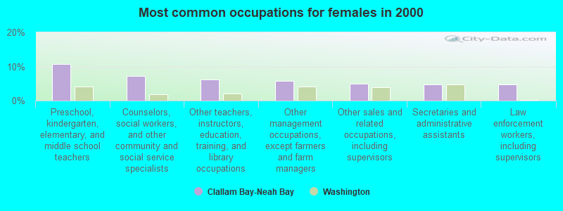
- Preschool, kindergarten, elementary, and middle school teachers (10.7%)
- Counselors, social workers, and other community and social service specialists (7.1%)
- Other teachers, instructors, education, training, and library occupations (6.2%)
- Other management occupations, except farmers and farm managers (5.7%)
- Other sales and related occupations, including supervisors (5.0%)
- Secretaries and administrative assistants (4.8%)
- Law enforcement workers, including supervisors (4.8%)
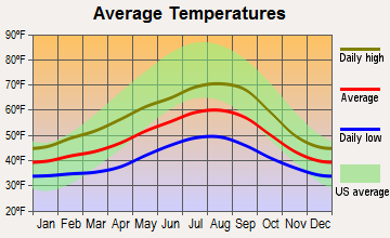
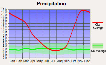
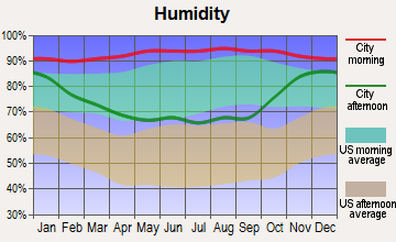
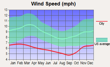
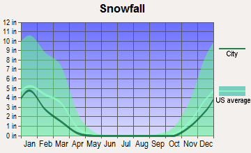
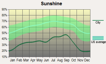
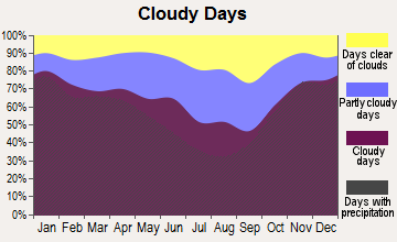
Average climate in Clallam Bay-Neah Bay, Washington
Based on data reported by over 4,000 weather stations
(lower is better)
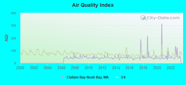
Air Quality Index (AQI) level in 2022 was 62.6. This is about average.
| City: | 62.6 |
| U.S.: | 72.6 |
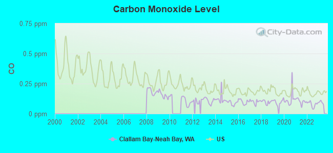
Carbon Monoxide (CO) [ppm] level in 2022 was 0.0785. This is significantly better than average. Closest monitor was 8.2 miles away from the city center.
| City: | 0.0785 |
| U.S.: | 0.2513 |
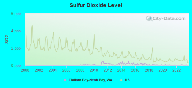
Sulfur Dioxide (SO2) [ppb] level in 2022 was 0.0339. This is significantly better than average. Closest monitor was 8.2 miles away from the city center.
| City: | 0.0339 |
| U.S.: | 1.5147 |
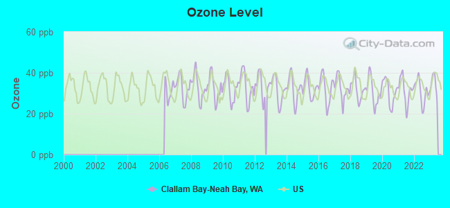
Ozone [ppb] level in 2022 was 30.8. This is about average. Closest monitor was 8.2 miles away from the city center.
| City: | 30.8 |
| U.S.: | 33.3 |
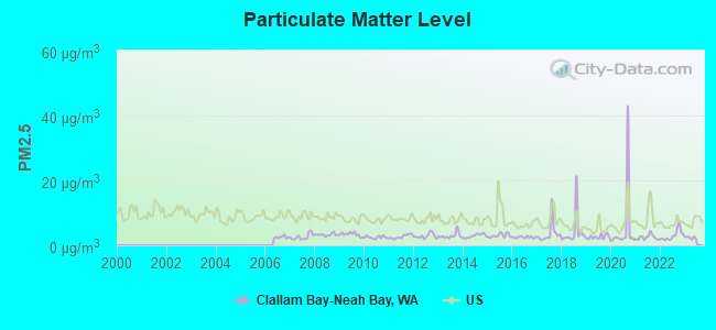
Particulate Matter (PM2.5) [µg/m3] level in 2022 was 3.07. This is significantly better than average. There were 0 monitors within city limits.
| City: | 3.07 |
| U.S.: | 8.11 |
Earthquake activity:
Clallam Bay-Neah Bay-area historical earthquake activity is significantly above Washington state average. It is 927% greater than the overall U.S. average.On 4/13/1949 at 19:55:42, a magnitude 7.0 (7.0 UK, Class: Major, Intensity: VIII - XII) earthquake occurred 114.3 miles away from the city center, causing $80,000,000 total damage
On 2/28/2001 at 18:54:32, a magnitude 6.8 (6.8 MD, Depth: 32.2 mi, Class: Strong, Intensity: VII - IX) earthquake occurred 110.6 miles away from the city center
On 2/28/2001 at 18:54:32, a magnitude 6.8 (6.5 MB, 6.6 MS, 6.8 MW) earthquake occurred 118.5 miles away from Clallam Bay-Neah Bay center, causing $2,000,000,000 total damage and $305,000,000 insured losses
On 4/29/1965 at 15:28:43, a magnitude 6.6 (6.6 UK) earthquake occurred 118.1 miles away from Clallam Bay-Neah Bay center, causing $28,000,000 total damage
On 7/3/1999 at 01:43:54, a magnitude 5.8 (5.4 MB, 5.5 MS, 5.8 MW, 5.3 ME, Depth: 25.2 mi, Class: Moderate, Intensity: VI - VII) earthquake occurred 99.5 miles away from Clallam Bay-Neah Bay center
On 1/31/1922 at 13:17:28, a magnitude 7.6 (7.6 UK) earthquake occurred 523.2 miles away from Clallam Bay-Neah Bay center
Magnitude types: body-wave magnitude (MB), duration magnitude (MD), energy magnitude (ME), surface-wave magnitude (MS), moment magnitude (MW)
Natural disasters:
The number of natural disasters in Clallam County (21) is greater than the US average (15).Major Disasters (Presidential) Declared: 19
Emergencies Declared: 1
Causes of natural disasters: Floods: 14, Mudslides: 10, Storms: 10, Landslides: 9, Winter Storms: 7, Winds: 5, Tornadoes: 2, Earthquake: 1, Hurricane: 1, Snow: 1, Volcanic Eruption: 1, Other: 1 (Note: some incidents may be assigned to more than one category).
Colleges/universities with over 2000 students nearest to Clallam Bay-Neah Bay:
- Peninsula College (about 51 miles; Port Angeles, WA; Full-time enrollment: 2,012)
- Olympic College (about 97 miles; Bremerton, WA; FT enrollment: 6,158)
- Western Washington University (about 99 miles; Bellingham, WA; FT enrollment: 13,875)
- Whatcom Community College (about 100 miles; Bellingham, WA; FT enrollment: 3,265)
- Skagit Valley College (about 102 miles; Mount Vernon, WA; FT enrollment: 3,803)
- Edmonds Community College (about 104 miles; Lynnwood, WA; FT enrollment: 7,271)
- Shoreline Community College (about 104 miles; Shoreline, WA; FT enrollment: 5,026)
Points of interest:
Notable locations in Clallam Bay-Neah Bay: Makah National Salmon Hatchery (A), Clallam Honor Camp (B), Ozette Campground (C), Clallam Bay Spit (D), Indian Village (E), Iverson Ranch (F), Hoko (G), Person Ranch (H), Makah Cultural and Research Center (I), Hoko Camp (J), Gibson Farm (K), Washburn Ranch (L), Wesseler Ranch (M), Sooes (N), Clallam River Campground (O), Makah Marina (P), Olson's Resort Marina (Q), Ericksons Bay Campground (R), Clallam Bay Correction Center Sewage Treatment Plant (S), Clallam Bay Sewage Treatment Plant (T). Display/hide their locations on the map
Churches in Clallam Bay-Neah Bay include: Neah Bay Assembly of God Church (A), Clallam Bay Presbyterian Church (B), Apostolic Faith Church (C), Makah Lutheran Church (D). Display/hide their locations on the map
Cemeteries: Old Cemetery (1), Old Clallam Bay Cemetery (2). Display/hide their locations on the map
Lakes: Dickey Lake (A), Ozette Lake (B), Seafield Lake (C), Lizard Lake (D), Elk Lake (E), Pysht Millpond (F), Willoughby Lake (G), Hobuck Lake (H). Display/hide their locations on the map
Streams, rivers, and creeks: Big River (A), Blowder Creek (B), Boe Creek (C), Brown Creek (D), Brownes Creek (E), Carpenters Creek (F), Charley Creek (G), Clallam River (H), Coke Creek (I). Display/hide their locations on the map
Parks in Clallam Bay-Neah Bay include: Norwegian Memorial (1), Olympic National Park (2). Display/hide their locations on the map
Beaches: Yellow Banks (A), Shi-Shi Beach (B), Chito Beach (C), Hobuck Beach (D), Warmhouse Beach (E), Sooes Beach (F), First Beach (G). Display/hide their locations on the map
| This place: | 2.5 people |
| Washington: | 2.5 people |
| This place: | 62.6% |
| Whole state: | 64.4% |
| This place: | 12.9% |
| Whole state: | 7.7% |
Likely homosexual households (counted as self-reported same-sex unmarried-partner households)
- Lesbian couples: 0.3% of all households
- Gay men: 0.0% of all households
| This place: | 24.9% |
| Whole state: | 10.6% |
| This place: | 12.3% |
| Whole state: | 4.6% |
People in group quarters in Clallam Bay-Neah Bay in 2010:
- 896 people in state prisons
- 5 people in local jails and other municipal confinement facilities
- 5 people in military barracks and dormitories (nondisciplinary)
People in group quarters in Clallam Bay-Neah Bay in 2000:
- 858 people in state prisons
- 13 people in military barracks, etc.
- 2 people in local jails and other confinement facilities (including police lockups)
For population 15 years and over in Clallam Bay-Neah Bay:
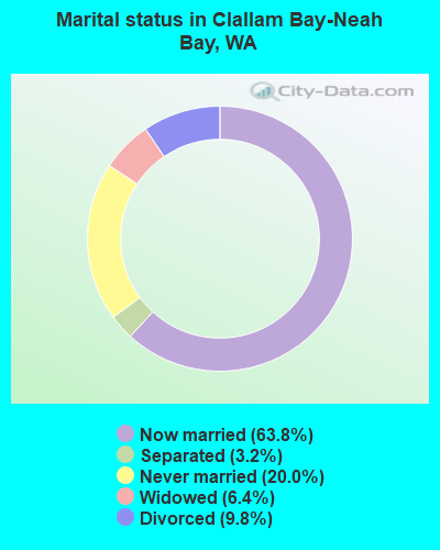
- Never married: 20.0%
- Now married: 63.8%
- Separated: 3.2%
- Widowed: 6.4%
- Divorced: 9.8%
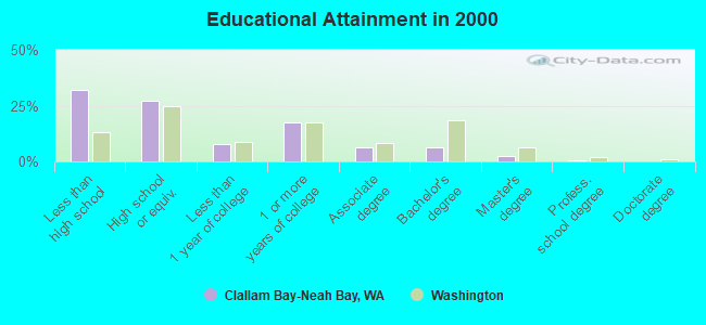
For population 25 years and over in Clallam Bay-Neah Bay:
- High school or higher: 68.1%
- Bachelor's degree or higher: 9.6%
- Graduate or professional degree: 3.2%
- Unemployed: 17.8%
- Mean travel time to work (commute): 20.0 minutes
| Here: | 12.6 |
| Washington average: | 11.3 |
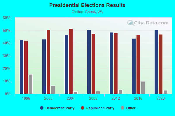
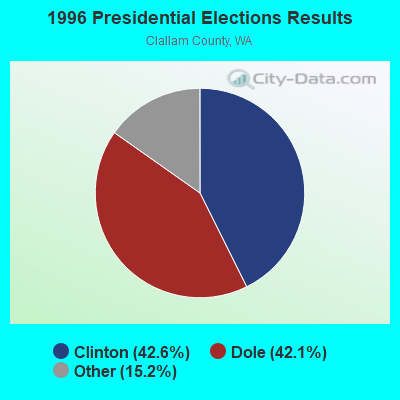
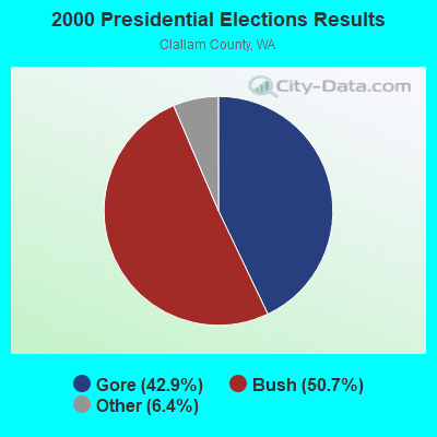
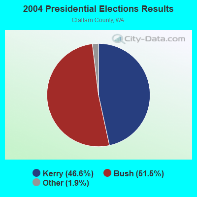
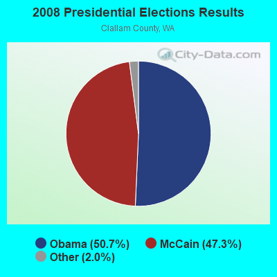
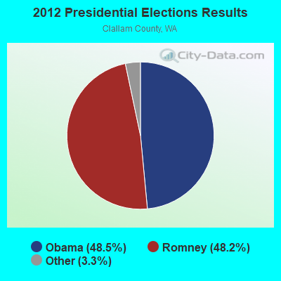
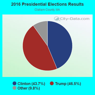

Graphs represent county-level data. Detailed 2008 Election Results
Religion statistics for Clallam Bay-Neah Bay, WA (based on Clallam County data)
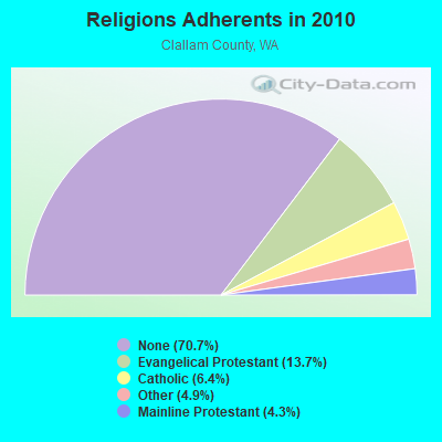
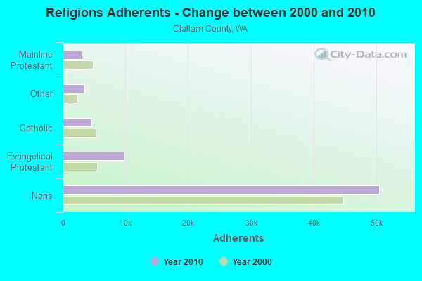
| Religion | Adherents | Congregations |
|---|---|---|
| Evangelical Protestant | 9,803 | 59 |
| Catholic | 4,581 | 4 |
| Other | 3,487 | 18 |
| Mainline Protestant | 3,035 | 13 |
| None | 50,498 | - |
Food Environment Statistics:
| Clallam County: | 2.42 / 10,000 pop. |
| State: | 2.06 / 10,000 pop. |
| Clallam County: | 0.14 / 10,000 pop. |
| Washington: | 0.19 / 10,000 pop. |
| This county: | 1.99 / 10,000 pop. |
| Washington: | 1.18 / 10,000 pop. |
| Clallam County: | 2.13 / 10,000 pop. |
| Washington: | 2.67 / 10,000 pop. |
| This county: | 11.09 / 10,000 pop. |
| Washington: | 8.26 / 10,000 pop. |
| Clallam County: | 8.9% |
| Washington: | 7.7% |
| This county: | 26.6% |
| Washington: | 25.7% |
| Here: | 15.1% |
| Washington: | 13.9% |
Strongest AM radio stations in Clallam Bay-Neah Bay:
- KIRO (710 AM; 50 kW; SEATTLE, WA; Owner: ENTERCOM SEATTLE LICENSE, LLC)
- KGNW (820 AM; 50 kW; BURIEN-SEATTLE, WA; Owner: INSPIRATION MEDIA, INC.)
- KTTH (770 AM; 50 kW; SEATTLE, WA; Owner: ENTERCOM SEATTLE LICENSE, LLC)
- KARI (550 AM; 25 kW; BLAINE, WA; Owner: WAY BROADCASTING, INC.)
- KOMO (1000 AM; 50 kW; SEATTLE, WA; Owner: FISHER BROADCASTING - SEATTLE RADIO, L.L.C.)
- KIXI (880 AM; 50 kW; MERCER ISLAND/SEATTL, WA; Owner: BELLEVUE RADIO, INC.)
- KKOL (1300 AM; 50 kW; SEATTLE, WA; Owner: INSPIRATION MEDIA, INC.)
- KYCW (1090 AM; 50 kW; SEATTLE, WA; Owner: INFINITY RADIO SUBSIDIARY OPERATIONS INC.)
- KJR (950 AM; 50 kW; SEATTLE, WA)
- KRPI (1550 AM; 50 kW; FERNDALE, WA; Owner: BBC BROADCASTING, INC.)
- KRKO (1380 AM; 50 kW; EVERETT, WA; Owner: S-R BROADCASTING, CO.)
- KVAC (1490 AM; 1 kW; FORKS, WA; Owner: ALCO SERVICES, INC.)
- KPOJ (620 AM; 50 kW; PORTLAND, OR; Owner: CITICASTERS LICENSES, L.P.)
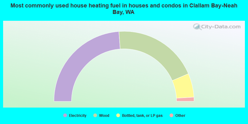
- 47.7%Electricity
- 39.4%Wood
- 11.0%Bottled, tank, or LP gas
- 0.9%Other fuel
- 0.6%Fuel oil, kerosene, etc.
- 0.3%Utility gas
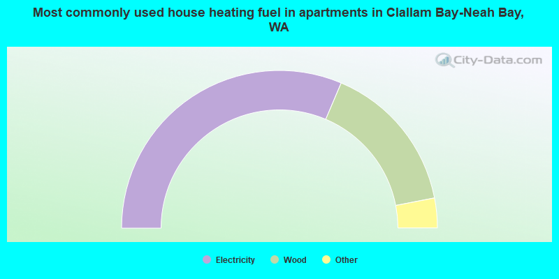
- 62.8%Electricity
- 31.1%Wood
- 3.4%Fuel oil, kerosene, etc.
- 2.7%Bottled, tank, or LP gas
Clallam Bay-Neah Bay compared to Washington state average:
- Median household income below state average.
- Median house value below state average.
- Black race population percentage above state average.
- Hispanic race population percentage below state average.
- Foreign-born population percentage significantly below state average.
- Length of stay since moving in significantly above state average.
- Number of rooms per house significantly below state average.
- House age significantly below state average.
- Institutionalized population percentage significantly above state average.
- Percentage of population with a bachelor's degree or higher significantly below state average.
Clallam Bay-Neah Bay on our top lists:
- #88 on the list of "Top 101 cities with the largest percentage of people in state prisons (population 1,000+)"
- #14 on the list of "Top 101 counties with the lowest Sulfur Oxides Annual air pollution readings in 2012 (µg/m3)"
- #17 on the list of "Top 101 counties with the highest number of deaths per 1000 residents 2007-2013 (pop. 50,000+)"
- #23 on the list of "Top 101 counties with the lowest surface withdrawal of fresh water for public supply (pop. 50,000+)"
- #82 on the list of "Top 101 counties with the largest number of people moving in compared to moving out (pop. 50,000+)"
- #87 on the list of "Top 101 counties with highest percentage of residents voting for 3rd party candidates in the 2012 Presidential Election (pop. 50,000+)"