Chippewa, Wisconsin
Submit your own pictures of this town and show them to the world
- OSM Map
- Google Map
- MSN Map
Population change since 2000: -13.6%
 |
| Males: 201 | |
| Females: 173 |
| Median resident age: | 45.1 years |
| Wisconsin median age: | 42.6 years |
Zip codes: 54527.
| Chippewa: | $74,446 |
| WI: | $70,996 |
Estimated per capita income in 2022: $33,127 (it was $16,841 in 2000)
Chippewa town income, earnings, and wages data
Estimated median house or condo value in 2022: $195,520 (it was $77,200 in 2000)
| Chippewa: | $195,520 |
| WI: | $252,800 |
Mean prices in 2022: all housing units: $185,124; detached houses: $192,443; townhouses or other attached units: $251,736; in 2-unit structures: $170,233; in 5-or-more-unit structures: $172,158; mobile homes: $91,935
Detailed information about poverty and poor residents in Chippewa, WI


- 36597.6%White alone
- 61.6%Two or more races
- 30.8%Hispanic

Races in Chippewa detailed stats: ancestries, foreign born residents, place of birth
 Recent articles from our blog. Our writers, many of them Ph.D. graduates or candidates, create easy-to-read articles on a wide variety of topics.
Ancestries: German (47.6%), Polish (14.3%), Irish (7.6%), English (7.2%), Norwegian (6.2%), Swedish (3.5%).
Current Local Time: CST time zone
Land area: 124.4 square miles.
Population density: 3.0 people per square mile (very low).
3 residents are foreign born
| This town: | 0.7% |
| Wisconsin: | 3.6% |
| Chippewa town: | 2.0% ($1,533) |
| Wisconsin: | 2.0% ($2,245) |
Nearest city with pop. 50,000+: Duluth, MN  (84.9 miles , pop. 86,918).
Nearest city with pop. 200,000+: St. Paul, MN (138.3 miles , pop. 287,151).
Nearest city with pop. 1,000,000+: Chicago, IL (326.6 miles , pop. 2,896,016).
Nearest cities:
), ), Latitude: 46.03 N, Longitude: 90.71 W
Area code commonly used in this area: 715

Single-family new house construction building permits:
- 2018: 1 building, cost: $235,000
- 2017: 3 buildings, average cost: $101,700
- 2015: 2 buildings, average cost: $147,500
- 2011: 2 buildings, average cost: $100,000
- 2010: 1 building, cost: $180,000
- 2009: 1 building, cost: $140,000
- 2008: 4 buildings, average cost: $53,800
- 2007: 3 buildings, average cost: $152,800
- 2006: 4 buildings, average cost: $138,800
- 2005: 1 building, cost: $50,000
- 2004: 2 buildings, average cost: $77,500
- 2003: 5 buildings, average cost: $89,000
- 2002: 1 building, cost: $40,000
- 2001: 5 buildings, average cost: $76,000
- 1999: 1 building, cost: $25,000
- 1998: 4 buildings, average cost: $38,800
- 1997: 2 buildings, average cost: $55,000


| Here: | 3.2% |
| Wisconsin: | 2.7% |

- Paper (14.4%)
- Health care (10.0%)
- Wood products (8.5%)
- Accommodation & food services (8.0%)
- Food & beverage stores (7.0%)
- Agriculture, forestry, fishing & hunting (6.0%)
- Educational services (4.5%)

- Paper (22.5%)
- Wood products (11.7%)
- Agriculture, forestry, fishing & hunting (10.8%)
- Educational services (6.3%)
- Construction (5.4%)
- Building material & garden equipment & supplies dealers (5.4%)
- Machinery (4.5%)

- Health care (22.2%)
- Accommodation & food services (17.8%)
- Food & beverage stores (15.6%)
- Miscellaneous manufacturing (6.7%)
- Public administration (6.7%)
- Wood products (4.4%)
- Paper (4.4%)

- Other production occupations, including supervisors (12.9%)
- Driver/sales workers and truck drivers (6.5%)
- Other management occupations, except farmers and farm managers (6.0%)
- Building and grounds cleaning and maintenance occupations (4.5%)
- Customer service representatives (4.0%)
- Cashiers (3.5%)
- Cooks and food preparation workers (3.5%)

- Other production occupations, including supervisors (17.1%)
- Driver/sales workers and truck drivers (11.7%)
- Building and grounds cleaning and maintenance occupations (8.1%)
- Electrical equipment mechanics and other installation, maintenance, and repair workers, including supervisors (5.4%)
- Woodworkers (5.4%)
- Fishing, hunting, and forestry occupations (4.5%)
- Other construction workers and helpers (3.6%)

- Other management occupations, except farmers and farm managers (11.1%)
- Cooks and food preparation workers (7.8%)
- Cashiers (7.8%)
- Other production occupations, including supervisors (7.8%)
- Registered nurses (5.6%)
- Supervisors and other personal care and service workers, except child care workers (5.6%)
- Waiters and waitresses (4.4%)
Average climate in Chippewa, Wisconsin
Based on data reported by over 4,000 weather stations


Tornado activity:
Chippewa-area historical tornado activity is significantly below Wisconsin state average. It is 53% smaller than the overall U.S. average.
On 6/8/1985, a category F3 (max. wind speeds 158-206 mph) tornado 13.4 miles away from the Chippewa town center killed 2 people and injured 42 people and caused between $5,000,000 and $50,000,000 in damages.
On 5/10/1953, a category F4 (max. wind speeds 207-260 mph) tornado 39.2 miles away from the town center killed 2 people and injured 24 people.
Earthquake activity:
Chippewa-area historical earthquake activity is significantly above Wisconsin state average. It is 73% smaller than the overall U.S. average.On 7/9/1975 at 14:54:15, a magnitude 4.6 (4.6 MB, Class: Light, Intensity: IV - V) earthquake occurred 258.1 miles away from the city center
On 6/5/1993 at 01:24:53, a magnitude 4.1 (4.1 LG, Depth: 6.2 mi) earthquake occurred 270.1 miles away from the city center
On 2/7/2020 at 18:30:28, a magnitude 3.3 (3.3 ML, Class: Light, Intensity: II - III) earthquake occurred 138.5 miles away from Chippewa center
On 4/8/2020 at 17:14:33, a magnitude 3.3 (3.3 ML) earthquake occurred 140.5 miles away from the city center
On 1/9/2020 at 18:16:48, a magnitude 3.3 (3.3 MB) earthquake occurred 140.5 miles away from the city center
On 3/2/2017 at 16:53:31, a magnitude 3.2 (3.2 ML) earthquake occurred 125.6 miles away from the city center
Magnitude types: regional Lg-wave magnitude (LG), body-wave magnitude (MB), local magnitude (ML)
Natural disasters:
The number of natural disasters in Ashland County (13) is near the US average (15).Major Disasters (Presidential) Declared: 11
Emergencies Declared: 2
Causes of natural disasters: Floods: 10, Storms: 7, Tornadoes: 2, Winds: 2, Drought: 1, Heavy Rain: 1, Hurricane: 1, Mudslide: 1, Other: 1 (Note: some incidents may be assigned to more than one category).
Colleges/universities with over 2000 students nearest to Chippewa:
- Wisconsin Indianhead Technical College (about 62 miles; Shell Lake, WI; Full-time enrollment: 2,414)
- University of Wisconsin-Superior (about 82 miles; Superior, WI; FT enrollment: 2,302)
- University of Minnesota-Duluth (about 86 miles; Duluth, MN; FT enrollment: 10,612)
- The College of Saint Scholastica (about 86 miles; Duluth, MN; FT enrollment: 3,762)
- Lake Superior College (about 87 miles; Duluth, MN; FT enrollment: 3,768)
- Northcentral Technical College (about 89 miles; Wausau, WI; FT enrollment: 3,356)
- University of Wisconsin-Eau Claire (about 94 miles; Eau Claire, WI; FT enrollment: 10,143)
Points of interest:
Notable locations in Chippewa: Stock Farm Bridge Recreation Site (A), Chippewa Townhall (B). Display/hide their locations on the map
Lakes: Pelican Lake (A), Snoose Lake (B), Slim Lake (C), Bullhead Lake (D), Camp Four Lake (E), Bear Lake (F), Cub Lake (G). Display/hide their locations on the map
Streams, rivers, and creeks: Rocky Run (A), Kelp Creek (B), Hungry Run (C), Hay Creek (D), Camp Fourteen Creek (E), Camp Fifteen Creek (F), Black Creek (G), Spring Brook (H), Reins Creek (I). Display/hide their locations on the map
| This town: | 2.5 people |
| Wisconsin: | 2.4 people |
| This town: | 69.7% |
| Whole state: | 64.4% |
| This town: | 5.9% |
| Whole state: | 7.3% |
No gay or lesbian households reported
| This town: | 8.7% |
| Whole state: | 8.7% |
| This town: | 5.2% |
| Whole state: | 3.7% |
For population 15 years and over in Chippewa:

- Never married: 21.1%
- Now married: 69.6%
- Separated: 0.0%
- Widowed: 6.7%
- Divorced: 2.6%
For population 25 years and over in Chippewa:
- High school or higher: 77.3%
- Bachelor's degree or higher: 8.3%
- Graduate or professional degree: 1.4%
- Unemployed: 2.4%
- Mean travel time to work (commute): 22.0 minutes


| Here: | 8.2 |
| Wisconsin average: | 11.0 |
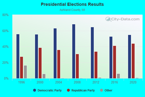
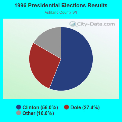
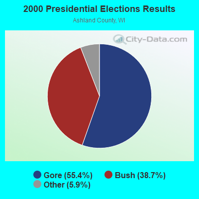
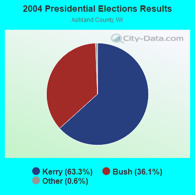
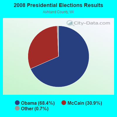
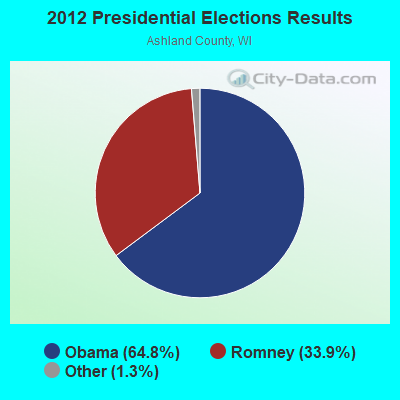
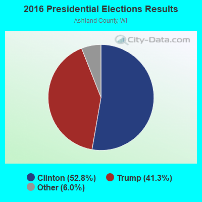
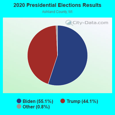
Graphs represent county-level data. Detailed 2008 Election Results
Religion statistics for Chippewa, WI (based on Ashland County data)
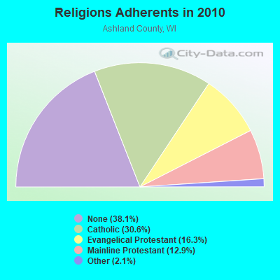
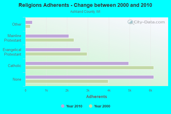
| Religion | Adherents | Congregations |
|---|---|---|
| Catholic | 4,952 | 8 |
| Evangelical Protestant | 2,633 | 14 |
| Mainline Protestant | 2,078 | 11 |
| Other | 334 | 4 |
| None | 6,160 | - |
Food Environment Statistics:
| Ashland County: | 4.92 / 10,000 pop. |
| Wisconsin: | 1.86 / 10,000 pop. |
| This county: | 0.61 / 10,000 pop. |
| State: | 0.38 / 10,000 pop. |
| Here: | 6.76 / 10,000 pop. |
| Wisconsin: | 4.12 / 10,000 pop. |
| Ashland County: | 18.44 / 10,000 pop. |
| State: | 8.64 / 10,000 pop. |
| This county: | 8.7% |
| Wisconsin: | 7.6% |
| This county: | 26.4% |
| State: | 27.5% |
| Here: | 11.7% |
| State: | 13.0% |
Strongest AM radio stations in Chippewa:
- WEBC (560 AM; 50 kW; DULUTH, MN)
- WJMS (590 AM; 5 kW; IRONWOOD, MI; Owner: ROBERTS BROADCASTING, INC.)
- WNBI (980 AM; 1 kW; PARK FALLS, WI)
- WSPT (1010 AM; 50 kW; STEVENS POINT, WI)
- WSAU (550 AM; 20 kW; WAUSAU, WI; Owner: WRIG, INC.)
- WHSM (910 AM; 5 kW; HAYWARD, WI; Owner: QB BROADCASTING, LTD.)
- WCCO (830 AM; 50 kW; MINNEAPOLIS, MN; Owner: INFINITY MEDIA CORPORATION)
- WCTS (1030 AM; 50 kW; MAPLEWOOD, MN; Owner: CNTL. BAPT. THEO/AL SEMI MINNEAPOLIS)
- WDSM (710 AM; 10 kW; SUPERIOR, WI; Owner: MIDWEST COMMUNICATIONS, INC.)
- KSTP (1500 AM; 50 kW; ST. PAUL, MN; Owner: KSTP-AM, LLC (DELAWARE))
- KFAN (1130 AM; 50 kW; MINNEAPOLIS, MN; Owner: AMFM RADIO LICENSES, L.L.C.)
- WWJC (850 AM; daytime; 10 kW; DULUTH, MN; Owner: WWJC, INC.)
- KTIS (900 AM; 25 kW; MINNEAPOLIS, MN; Owner: NORTHWESTERN COLLEGE)
Strongest FM radio stations in Chippewa:
- WCQM (98.3 FM; PARK FALLS, WI; Owner: MIDWEST RADIO NETWORK, LLC)
- WHBM-FM (90.3 FM; PARK FALLS, WI; Owner: STATE OF WISCONSIN - EDUCATIONAL COMMUNICATIONS BOARD)
- WOJB (88.9 FM; RESERVE, WI; Owner: LAC COURTE OREILLES OJIBWA PUBLIC)
TV broadcast stations around Chippewa:
- WLEF-TV (Channel 36; PARK FALLS, WI; Owner: STATE OF WISCONSIN - EDUCATIONAL COMMUNICATIONS BOARD)
- National Bridge Inventory (NBI) Statistics
- 2Number of bridges
- 10ft / 3.3mTotal length
- 373Total average daily traffic
- 409Total future (year 2039) average daily traffic
FCC Registered Broadcast Land Mobile Towers:
1- WICH TWIN MHP LLC, Lat: 44.974306 Lon: -91.437889, Call Sign: WRTL437, Licensee ID: L01502812,
Assigned Frequencies: 451.187 MHz, Grant Date: 06/30/2022, Expiration Date: 06/30/2032, Certifier: Yarum Locker, Registrant: Cereniti Datasense Networks, 8765 Guion Rd., Suite D, Indianapolis, IN 46268, Phone: (877) 237-3648, Fax: (877) 362-6640, Email:
FCC Registered Microwave Towers:
2- WQRB-FM TRANSMITTER, 4.7 Km Ese Of Albertville (Lat: 44.928611 Lon: -91.542222), Type: Tower, Structure height: 125 m, Overall height: 125.9 m, Call Sign: WPTY392,
Assigned Frequencies: 944.875 MHz, Grant Date: 01/11/2002, Expiration Date: 12/01/2028, Certifier: Stephen G Davis, Registrant: Iheartmedia, Inc., 7136 S. Yale Avenue, Suite 501, Tulsa, OK 74136, Phone: (918) 664-4581, Fax: (918) 664-3066, Email:
- Chippewa Falls, WI, Lat: 44.936278 Lon: -91.392694, Call Sign: WPUR271,
Assigned Frequencies: 956.318 MHz, 956.318 MHz, Grant Date: 05/26/2022, Expiration Date: 04/17/2032, Certifier: John Allen, Registrant: City Of Chippewa Falls, 30 W Central Street, Room 209, Chippewa Falls, WI 54729, Phone: (715) 726-2741, Fax: (715) 726-2750, Email:
FCC Registered Amateur Radio Licenses:
3- Call Sign: KC9HYI, Licensee ID: L01046593, Grant Date: 08/13/2015, Expiration Date: 08/01/2025, Certifier: Peter T Peloquin, Registrant: Peter T Peloquin, 2101 150th St, Chippewa, WI 54729-0021
- Call Sign: KC9NME, Licensee ID: L01393274, Grant Date: 04/24/2008, Expiration Date: 04/24/2018, Cancellation Date: 10/20/2008, Certifier: Jerry M Anders, Registrant: Jerry M Anders, 13128 35th Ave, Chippewa, WI 54729
- Call Sign: KC9OLC, Previous Call Sign: KC9NME, Licensee ID: L01393274, Grant Date: 02/06/2018, Expiration Date: 04/24/2028, Certifier: Jerry M Anders, Registrant: Jerry M Anders, 13128 35th Ave, Chippewa, WI 54729

- 47.3%Wood
- 41.2%Bottled, tank, or LP gas
- 6.1%Fuel oil, kerosene, etc.
- 4.1%Electricity
- 1.4%Utility gas

- 57.1%Bottled, tank, or LP gas
- 42.9%Wood
Chippewa compared to Wisconsin state average:
- Unemployed percentage significantly below state average.
- Black race population percentage significantly below state average.
- Hispanic race population percentage significantly below state average.
- Foreign-born population percentage significantly below state average.
- Renting percentage significantly below state average.
- Length of stay since moving in significantly above state average.
- Number of rooms per house significantly below state average.
- House age significantly below state average.
- Number of college students below state average.
- Percentage of population with a bachelor's degree or higher significantly below state average.