Cato, Wisconsin
Submit your own pictures of this town and show them to the world
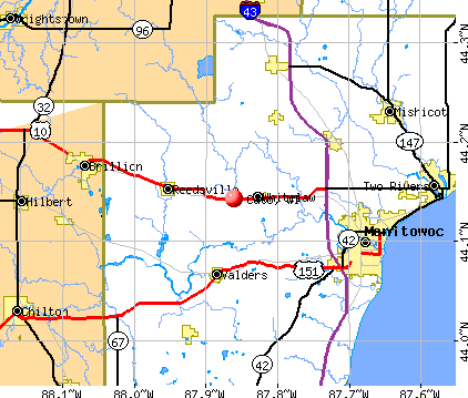
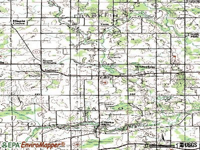
- OSM Map
- General Map
- Google Map
- MSN Map
Population change since 2000: -3.1%
 |
| Males: 813 | |
| Females: 753 |
| Median resident age: | 44.2 years |
| Wisconsin median age: | 42.6 years |
Zip codes: 54230.
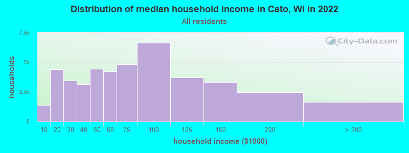
| Cato: | $76,172 |
| WI: | $70,996 |
Estimated per capita income in 2022: $35,852 (it was $21,434 in 2000)
Cato town income, earnings, and wages data
Estimated median house or condo value in 2022: $219,381 (it was $120,600 in 2000)
| Cato: | $219,381 |
| WI: | $252,800 |
Mean prices in 2022: all housing units: $213,664; detached houses: $222,777; townhouses or other attached units: $189,612; in 2-unit structures: $121,476; in 3-to-4-unit structures: $125,936; in 5-or-more-unit structures: $113,942; mobile homes: $52,862
Detailed information about poverty and poor residents in Cato, WI


- 1,52597.4%White alone
- 181.1%Hispanic
- 110.7%Asian alone
- 50.3%American Indian alone
- 40.3%Two or more races
- 20.1%Black alone
- 10.06%Other race alone
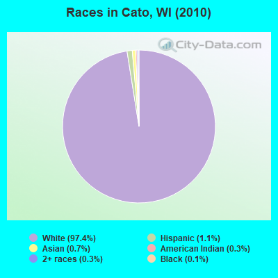
Races in Cato detailed stats: ancestries, foreign born residents, place of birth
According to our research of Wisconsin and other state lists, there were 2 registered sex offenders living in Cato, Wisconsin as of May 12, 2024.
The ratio of all residents to sex offenders in Cato is 783 to 1.
The ratio of registered sex offenders to all residents in this city is lower than the state average.
 Recent articles from our blog. Our writers, many of them Ph.D. graduates or candidates, create easy-to-read articles on a wide variety of topics.

 | The racism in Milwaukee continues and it's disgusting (117 replies) |
| Another round of Gov. Scott Walker (188 replies) |
| Wisconsin Thoughts on Midwest High Speed Rail? (144 replies) |
| Wisconsin (28 replies) |
Latest news from Cato, WI collected exclusively by city-data.com from local newspapers, TV, and radio stations
Ancestries: German (69.6%), Irish (15.6%), Czech (12.3%), Norwegian (8.3%), Polish (7.1%), United States (4.5%).
Current Local Time: CST time zone
Elevation: 863 feet
Land area: 35.1 square miles.
Population density: 45 people per square mile (very low).
9 residents are foreign born
| This town: | 0.6% |
| Wisconsin: | 3.6% |
| Cato town: | 1.8% ($2,154) |
| Wisconsin: | 2.0% ($2,245) |
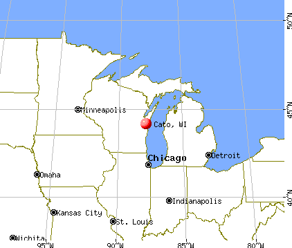
Nearest city with pop. 50,000+: Sheboygan, WI  (25.3 miles , pop. 50,792).
Nearest city with pop. 200,000+: Milwaukee, WI (72.9 miles , pop. 596,974).
Nearest city with pop. 1,000,000+: Chicago, IL (156.8 miles , pop. 2,896,016).
Nearest cities:
), ), ), ), ), ), )Latitude: 44.10 N, Longitude: 87.86 W
Area code commonly used in this area: 920
| Here: | 2.6% |
| Wisconsin: | 2.7% |
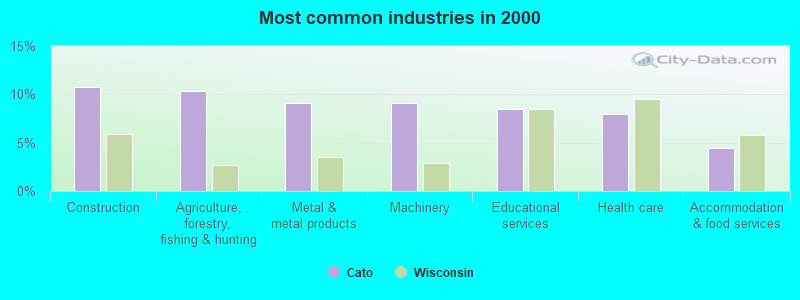
- Construction (10.8%)
- Agriculture, forestry, fishing & hunting (10.4%)
- Metal & metal products (9.1%)
- Machinery (9.1%)
- Educational services (8.4%)
- Health care (7.9%)
- Accommodation & food services (4.4%)
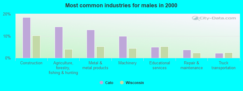
- Construction (18.5%)
- Agriculture, forestry, fishing & hunting (14.3%)
- Metal & metal products (12.8%)
- Machinery (10.0%)
- Educational services (5.0%)
- Repair & maintenance (3.7%)
- Truck transportation (2.2%)
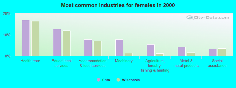
- Health care (16.9%)
- Educational services (12.7%)
- Accommodation & food services (7.9%)
- Machinery (7.9%)
- Agriculture, forestry, fishing & hunting (5.6%)
- Metal & metal products (4.4%)
- Social assistance (3.5%)
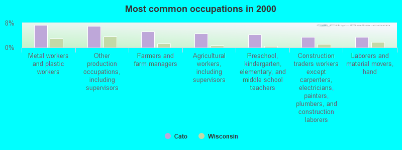
- Metal workers and plastic workers (7.3%)
- Other production occupations, including supervisors (7.1%)
- Farmers and farm managers (5.2%)
- Agricultural workers, including supervisors (4.6%)
- Preschool, kindergarten, elementary, and middle school teachers (4.2%)
- Construction traders workers except carpenters, electricians, painters, plumbers, and construction laborers (3.5%)
- Laborers and material movers, hand (3.4%)
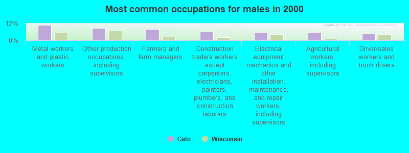
- Metal workers and plastic workers (10.9%)
- Other production occupations, including supervisors (8.7%)
- Farmers and farm managers (8.0%)
- Construction traders workers except carpenters, electricians, painters, plumbers, and construction laborers (6.3%)
- Electrical equipment mechanics and other installation, maintenance, and repair workers, including supervisors (5.9%)
- Agricultural workers, including supervisors (5.7%)
- Driver/sales workers and truck drivers (4.6%)
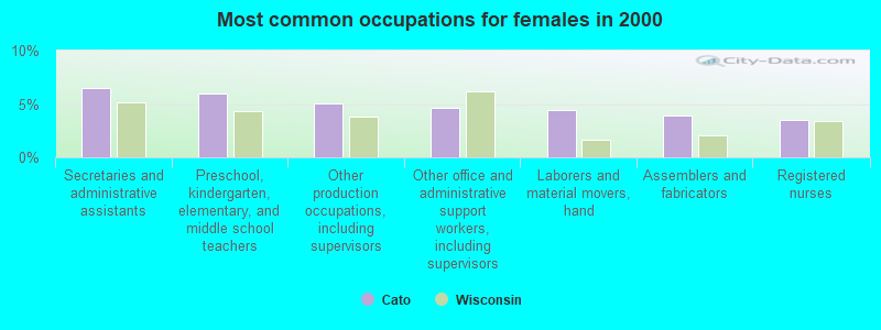
- Secretaries and administrative assistants (6.5%)
- Preschool, kindergarten, elementary, and middle school teachers (6.0%)
- Other production occupations, including supervisors (5.1%)
- Other office and administrative support workers, including supervisors (4.6%)
- Laborers and material movers, hand (4.4%)
- Assemblers and fabricators (3.9%)
- Registered nurses (3.5%)
Average climate in Cato, Wisconsin
Based on data reported by over 4,000 weather stations


(lower is better)
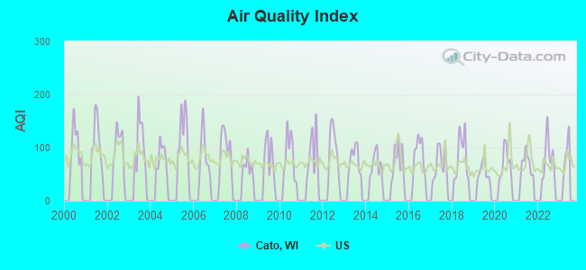
Air Quality Index (AQI) level in 2022 was 80.1. This is about average.
| City: | 80.1 |
| U.S.: | 72.6 |
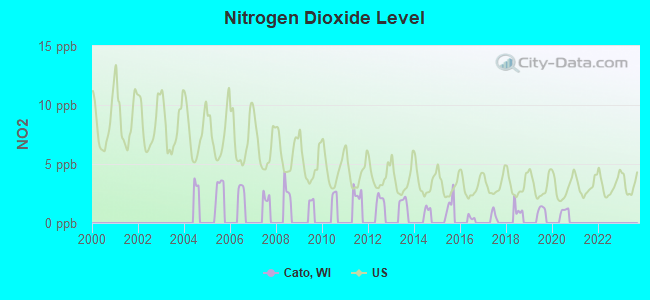
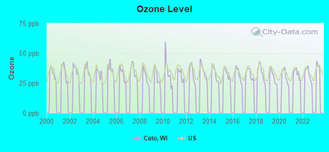
Ozone [ppb] level in 2022 was 33.1. This is about average. Closest monitor was 4.1 miles away from the city center.
| City: | 33.1 |
| U.S.: | 33.3 |
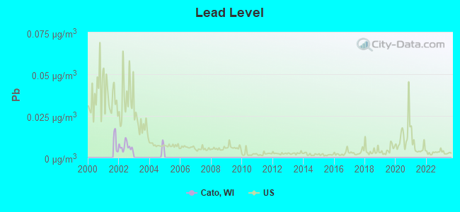
Lead (Pb) [µg/m3] level in 2002 was 0.00649. This is significantly better than average. Closest monitor was 9.8 miles away from the city center.
| City: | 0.00649 |
| U.S.: | 0.00931 |
Tornado activity:
Cato-area historical tornado activity is slightly below Wisconsin state average. It is 2% smaller than the overall U.S. average.
On 7/5/1994, a category F4 (max. wind speeds 207-260 mph) tornado 12.4 miles away from the Cato town center injured 2 people and caused between $500,000 and $5,000,000 in damages.
On 7/18/1996, a category F5 (max. wind speeds 261-318 mph) tornado 37.1 miles away from the town center injured 12 people and caused $40 million in damages.
Earthquake activity:
Cato-area historical earthquake activity is significantly above Wisconsin state average. It is 17% smaller than the overall U.S. average.On 4/18/2008 at 09:36:59, a magnitude 5.4 (5.1 MB, 4.8 MS, 5.4 MW, 5.2 MW, Class: Moderate, Intensity: VI - VII) earthquake occurred 390.9 miles away from Cato center
On 5/2/2015 at 16:23:07, a magnitude 4.2 (4.2 MW, Depth: 2.8 mi, Class: Light, Intensity: IV - V) earthquake occurred 178.0 miles away from Cato center
On 6/28/2004 at 06:10:52, a magnitude 4.2 (4.2 MW, Depth: 6.2 mi) earthquake occurred 190.3 miles away from Cato center
On 6/10/1987 at 23:48:54, a magnitude 5.1 (4.9 MB, 4.4 MS, 4.6 MS, 5.1 LG) earthquake occurred 365.4 miles away from Cato center
On 4/18/2008 at 09:36:59, a magnitude 5.2 (5.2 MW, Depth: 8.9 mi) earthquake occurred 390.9 miles away from Cato center
On 2/10/2010 at 09:59:35, a magnitude 3.8 (3.8 MW, Depth: 6.2 mi, Class: Light, Intensity: II - III) earthquake occurred 151.1 miles away from Cato center
Magnitude types: regional Lg-wave magnitude (LG), body-wave magnitude (MB), surface-wave magnitude (MS), moment magnitude (MW)
Natural disasters:
The number of natural disasters in Manitowoc County (7) is smaller than the US average (15).Major Disasters (Presidential) Declared: 5
Emergencies Declared: 2
Causes of natural disasters: Floods: 4, Storms: 4, Tornadoes: 2, Hurricane: 1, Wind: 1, Winter Storm: 1, Other: 1 (Note: some incidents may be assigned to more than one category).
Hospitals and medical centers near Cato:
- MANITOWOC HEALTH CARE CENTER (Nursing Home, about 7 miles away; MANITOWOC, WI)
- RIVERS BEND HLTH REHAB (Nursing Home, about 8 miles away; MANITOWOC, WI)
- RAINBOW HOUSE FDD (Hospital, about 9 miles away; MANITOWOC, WI)
- SHADY LANE HOME INC (Nursing Home, about 10 miles away; MANITOWOC, WI)
- SHADY LANE NURSING CARE CENTER (Nursing Home, about 10 miles away; MANITOWOC, WI)
- HOLY FAMILY MEMORIAL INC Acute Care Hospitals (about 10 miles away; MANITOWOC, WI)
- HOLY FAMILY MEM TRANS CARE (Nursing Home, about 10 miles away; MANITOWOC, WI)
Operable nuclear power plants near Cato:
- 15 miles: Point Beach 1 and 2 in Two Rivers, WI.
Colleges/universities with over 2000 students nearest to Cato:
- Lakeland College (about 19 miles; Plymouth, WI; Full-time enrollment: 2,395)
- Saint Norbert College (about 26 miles; De Pere, WI; FT enrollment: 2,324)
- Lawrence University (about 29 miles; Appleton, WI; FT enrollment: 2,821)
- University of Wisconsin-Green Bay (about 30 miles; Green Bay, WI; FT enrollment: 5,415)
- Northeast Wisconsin Technical College (about 32 miles; Green Bay, WI; FT enrollment: 6,069)
- Fox Valley Technical College (about 33 miles; Appleton, WI; FT enrollment: 5,682)
- University of Wisconsin-Oshkosh (about 35 miles; Oshkosh, WI; FT enrollment: 10,637)
Points of interest:
Notable locations in Cato: Whitelaw Wastewater Treatment Plant (A), Satoris Farms (B), Braun Earth Acres (C), Cato Falls Dairy (D), Hy Point Farm (E), Pine Lawn Farms (F), Hyland Dairy (G), Waack Family Farms (H), Welsh Farm (I), Fritsch Lane Dairy (J), Sunset Valley Farms (K), Jersey Hill Farm (L), Royal Blue Farms (M), Lannbrecht Little Brook Farms (N), Irishway Dairy Farm (O), Marsh Edge Dairy (P), Whitelaw Volunteer Fire Department (Q). Display/hide their locations on the map
Churches in Cato include: Saint Marys Church (A), Saint Michaels Catholic Church (B). Display/hide their locations on the map
Cemeteries: Grace Cemetery (1), Saint Michaels Catholic Cemetery (2), Cato Heights Cemetery (3), Saint Mary Cemetery (4), Gjerpen Cemetery (5). Display/hide their locations on the map
Lakes and reservoirs: Schisel Lake (A), Bergene Lake (B), Hempton Lake (C), Clark Mills Pond 411 (D). Display/hide their locations on the map
Park in Cato: Lower Cato Falls County Park (1). Display/hide its location on the map
Birthplace of: Thorstein Veblen - Academic.
Drinking water stations with addresses in Cato that have no violations reported:
- SEVEN LAKES GOLF COURSE (Population served: 25, Primary Water Source Type: Groundwater)
| This town: | 2.6 people |
| Wisconsin: | 2.4 people |
| This town: | 81.9% |
| Whole state: | 64.4% |
| This town: | 4.1% |
| Whole state: | 7.3% |
Likely homosexual households (counted as self-reported same-sex unmarried-partner households)
- Lesbian couples: 0.2% of all households
- Gay men: 0.2% of all households
| This town: | 4.9% |
| Whole state: | 8.7% |
| This town: | 1.4% |
| Whole state: | 3.7% |
For population 15 years and over in Cato:
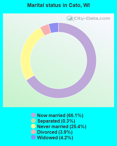
- Never married: 25.4%
- Now married: 66.1%
- Separated: 0.3%
- Widowed: 4.2%
- Divorced: 3.9%
For population 25 years and over in Cato:
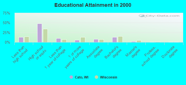
- High school or higher: 87.0%
- Bachelor's degree or higher: 15.7%
- Graduate or professional degree: 2.8%
- Unemployed: 2.8%
- Mean travel time to work (commute): 22.1 minutes
| Here: | 9.4 |
| Wisconsin average: | 11.0 |
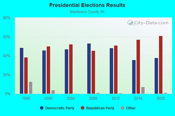

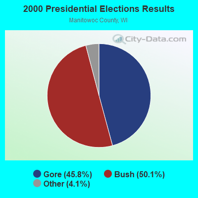
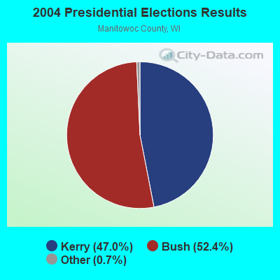
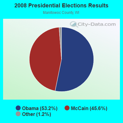
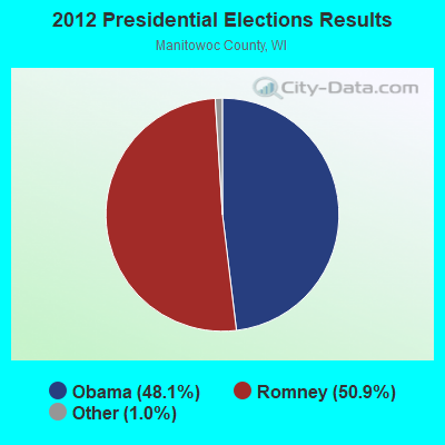
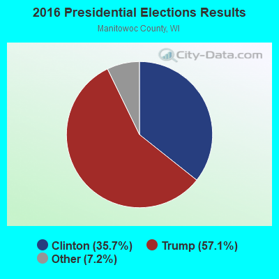
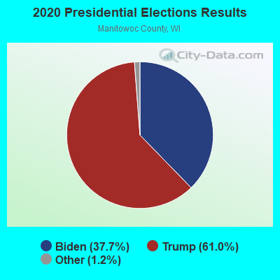
Graphs represent county-level data. Detailed 2008 Election Results
Religion statistics for Cato, WI (based on Manitowoc County data)
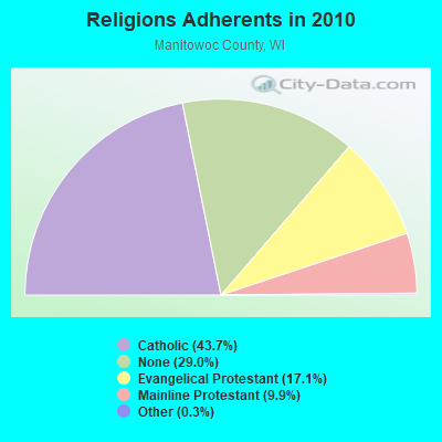
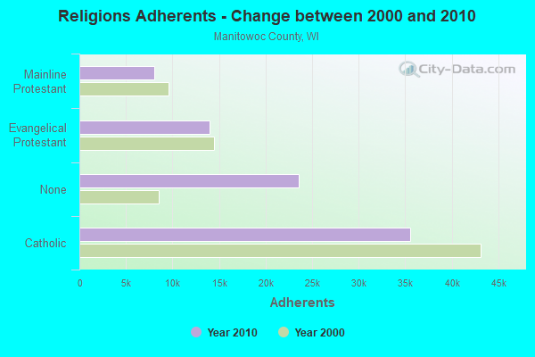
| Religion | Adherents | Congregations |
|---|---|---|
| Catholic | 35,564 | 14 |
| Evangelical Protestant | 13,965 | 42 |
| Mainline Protestant | 8,051 | 21 |
| Other | 259 | 4 |
| None | 23,603 | - |
Food Environment Statistics:
| Manitowoc County: | 1.24 / 10,000 pop. |
| State: | 1.86 / 10,000 pop. |
| Manitowoc County: | 0.12 / 10,000 pop. |
| Wisconsin: | 0.11 / 10,000 pop. |
| Manitowoc County: | 0.12 / 10,000 pop. |
| State: | 0.38 / 10,000 pop. |
| This county: | 4.09 / 10,000 pop. |
| State: | 4.12 / 10,000 pop. |
| Here: | 8.05 / 10,000 pop. |
| State: | 8.64 / 10,000 pop. |
| Here: | 7.8% |
| Wisconsin: | 7.6% |
| Manitowoc County: | 29.2% |
| State: | 27.5% |
| This county: | 14.8% |
| Wisconsin: | 13.0% |
Strongest AM radio stations in Cato:
- WCUB (980 AM; 5 kW; TWO RIVERS, WI; Owner: CUB RADIO, INC.)
- WNAM (1280 AM; 50 kW; NEENAH-MENASHA, WI; Owner: CUMULUS LICENSING CORP.)
- WHBY (1150 AM; 25 kW; KIMBERLY, WI; Owner: WOODWARD COMMUNICATIONS, INC.)
- WTAQ (1360 AM; 10 kW; GREEN BAY, WI; Owner: MIDWEST COMMUNICATIONS, INC.)
- WTMJ (620 AM; 50 kW; MILWAUKEE, WI; Owner: JOURNAL BROADCAST CORPORATION)
- WOMT (1240 AM; 1 kW; MANITOWOC, WI; Owner: SEEHAFER BROADCASTING CORP)
- WSPT (1010 AM; 50 kW; STEVENS POINT, WI)
- WHBL (1330 AM; 5 kW; SHEBOYGAN, WI; Owner: MIDWEST COMMUNICATIONS, INC.)
- WISN (1130 AM; 50 kW; MILWAUKEE, WI; Owner: CAPSTAR TX LIMITED PARTNERSHIP)
- WNFL (1440 AM; 5 kW; GREEN BAY, WI; Owner: MIDWEST COMMUNICATIONS, INC.)
- WTCM (580 AM; 35 kW; TRAVERSE CITY, MI; Owner: WTCM RADIO, INC.)
- WSAU (550 AM; 20 kW; WAUSAU, WI; Owner: WRIG, INC.)
- WGN (720 AM; 50 kW; CHICAGO, IL; Owner: WGN CONTINENTAL BROADCASTING CO.)
Strongest FM radio stations in Cato:
- W215BF (90.9 FM; MANITOWOC, WI; Owner: CALVARY CHAPEL OF TWIN FALLS, INC.)
- WHID (88.1 FM; GREEN BAY, WI; Owner: BD OF REGENTS OF THE UNIV OF WI SYS)
- WXWX (107.5 FM; BRILLION, WI; Owner: CUMULUS LICENSING CORP.)
- WIXX (101.1 FM; GREEN BAY, WI; Owner: MIDWEST COMMUNICATIONS, INC.)
- WLKN (98.1 FM; CLEVELAND, WI; Owner: RADIO K-T, INC.)
- WOGB (103.1 FM; KAUKAUNA, WI; Owner: CUMULUS LICENSING CORP.)
- WLTU (92.1 FM; MANITOWOC, WI; Owner: CUB RADIO, INC.)
- WPNE-FM (89.3 FM; GREEN BAY, WI; Owner: WISCONSIN EDUCATIONAL COMMUNICATIONS BOARD)
- WAPL-FM (105.7 FM; APPLETON, WI; Owner: WOODWARD COMMUNICATIONS, INC.)
- WORQ (90.1 FM; GREEN BAY, WI; Owner: LAKESHORE COMMUNICATIONS, INC.)
- WKSZ (95.9 FM; DE PERE, WI; Owner: WOODWARD COMMUNICATIONS INC)
- WQTC-FM (102.3 FM; MANITOWOC, WI; Owner: SEEHAFER BROADCASTING CORPORATION)
- WZOR (94.7 FM; MISHICOT, WI; Owner: WOODWARD COMMUNICATIONS, INC.)
- WPCK (104.9 FM; KAUKAUNA, WI; Owner: MIDWEST DIMENSIONS, INC.)
- WEMY (91.5 FM; GREEN BAY, WI; Owner: EVANGEL MINISTRIES, INC)
- WJLW (106.7 FM; ALLOUEZ, WI; Owner: CUMULUS LICENSING CORP)
- WSTM (91.3 FM; KIEL, WI; Owner: JUBILATION MINISTRIES INC)
- W270AJ (101.9 FM; GREEN BAY, WI; Owner: MIDWEST COMMUNICATIONS, INC)
- WNCY-FM (100.3 FM; NEENAH-MENASHA, WI; Owner: MIDWEST COMMUNICATIONS, INC.)
TV broadcast stations around Cato:
- WLUK-TV (Channel 11; GREEN BAY, WI; Owner: EMMIS TELEVISION LICENSE CORPORATION)
- WFRV-TV (Channel 5; GREEN BAY, WI; Owner: CBS BROADCASTING INC.)
- WBAY-TV (Channel 2; GREEN BAY, WI; Owner: YOUNG BROADCASTING OF GREEN BAY, INC.)
- WGBA (Channel 26; GREEN BAY, WI; Owner: ARIES TELECOMMUNICATION CORPORATION)
- WACY (Channel 32; APPLETON, WI; Owner: ACE TV, INC.)
- WPNE (Channel 38; GREEN BAY, WI; Owner: WISCONSIN EDUCATIONAL COMMUNICATIONS BOARD)
- WMMF-TV (Channel 68; FOND DU LAC, WI; Owner: PAPPAS TELECASTING OF WISCONSIN, A CALIFORNIA LTD PARTNRSHP)
- W49CB (Channel 49; GREEN BAY, WI; Owner: TRINITY BROADCASTING NETWORK)
- W30BU (Channel 30; GREEN BAY, WI; Owner: THREE ANGELS BROADCASTING NETWORK)
- WIWB (Channel 14; SURING, WI; Owner: ACME TV LICENSES OF WISCONSIN, LLC)
Cato fatal accident list:
- National Bridge Inventory (NBI) Statistics
- 7Number of bridges
- 69ft / 20.6mTotal length
- $408,000Total costs
- 5,354Total average daily traffic
- 72Total average daily truck traffic
- 5,907Total future (year 2039) average daily traffic
FCC Registered Antenna Towers:
18 (See the full list of FCC Registered Antenna Towers in Cato)FCC Registered Private Land Mobile Towers:
1- 9526 Hilltop Rd (Lat: 44.124722 Lon: -87.790917), Structure height: 61 m, Call Sign: WNRQ842, Licensee ID: L00003484,
Assigned Frequencies: 861.062 MHz, 862.362 MHz, 863.362 MHz, 864.062 MHz, 865.062 MHz, Grant Date: 07/09/2000, Expiration Date: 07/09/2010, Cancellation Date: 05/27/2010, Certifier: Dave Haller, Registrant: Nextel License Holdings 4, Inc, 2001 Edmund Halley Drive, Reston, VA 20191, Phone: (703) 433-4000, Fax: (703) 433-4035, Email:
FCC Registered Broadcast Land Mobile Towers:
2- Lat: 44.110056 Lon: -87.861583, Call Sign: WPWT283,
Assigned Frequencies: 466.050 MHz, 461.150 MHz, 469.075 MHz, Grant Date: 01/06/2023, Expiration Date: 01/16/2033, Certifier: Nick Staudinger, Registrant: Franks Radio Service, Inc., 4410 Custer Street, Manitowoc, WI 54220, Phone: (920) 682-5989, Fax: (920) 682-6027, Email:
- Lat: 44.131667 Lon: -87.796389, Call Sign: WRMN527,
Assigned Frequencies: 151.857 MHz, 152.892 MHz, Grant Date: 05/07/2021, Expiration Date: 05/07/2031, Certifier: Mark Otto, Registrant: Frank\'s Radio Service Inc., 4410 Custer St, Manitowoc, WI 54220, Phone: (920) 682-5989, Fax: (920) 682-6027, Email:
FCC Registered Microwave Towers:
2- Cato, 13615 Mcguire Road (Lat: 44.115278 Lon: -87.857583), Type: Gtower, Structure height: 91 m, Overall height: 97.5 m, Call Sign: WRDZ481,
Assigned Frequencies: 11155.0 MHz, 11155.0 MHz, 17820.0 MHz, 17900.0 MHz, 11155.0 MHz, 11155.0 MHz, 17820.0 MHz, 17900.0 MHz, 11155.0 MHz, 11155.0 MHz... (+98 more), Grant Date: 08/27/2019, Expiration Date: 08/27/2029, Certifier: James R Bertram, Registrant: Bertram Communications, 300 Industrial Drive, Random Lake, WI 53075, Phone: (920) 994-2388, Fax: (920) 994-9990, Email:
- JAMES AND BETTY PRIT, 13435 Ush 10 (Lat: 44.141194 Lon: -87.855861), Type: Ltower, Structure height: 79.2 m, Overall height: 85.3 m, Call Sign: WRMI252,
Assigned Frequencies: 10815.0 MHz, 10855.0 MHz, Grant Date: 04/13/2021, Expiration Date: 04/13/2031, Certifier: Mike Hargrove, Registrant: At&t Services, Inc., 208 S Akard St, 20f, Dallas, TX 75202, Phone: (855) 699-7073, Email:
FCC Registered Amateur Radio Licenses:
1- Call Sign: KB9KPW, Grant Date: 05/23/1995, Expiration Date: 05/23/2005, Cancellation Date: 05/24/2007, Registrant: Gary R Linders, 501 Valley Ln, Cato, WI 54206
FAA Registered Aircraft:
1- Aircraft: CESSNA 172 (Category: Land, Seats: 4, Weight: Up to 12,499 Pounds, Speed: 105 mph), Engine: CONT MOTOR 0-300 SER (145 HP) (Reciprocating)
N-Number: 6924A, N6924A, N-6924A, Serial Number: 29024, Year manufactured: 1956, Airworthiness Date: 08/14/1956, Certificate Issue Date: 01/27/1986
Registrant (Individual): Gary R Huempener, 3826 Highway H Rd, Cato, WI 54230
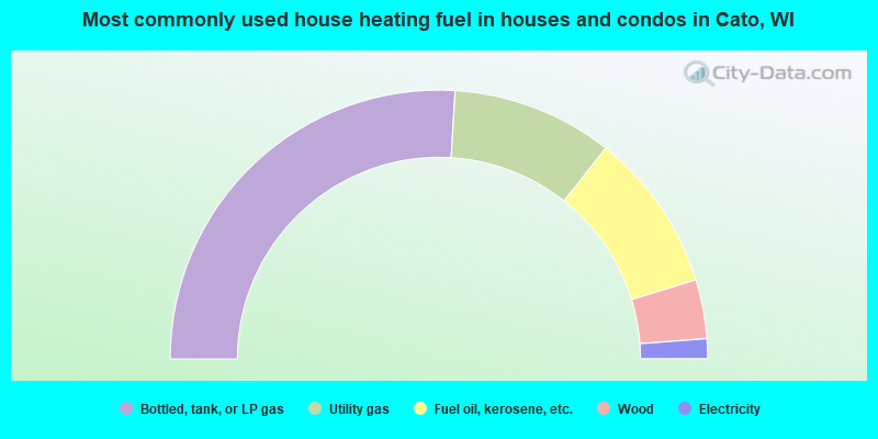
- 52.0%Bottled, tank, or LP gas
- 19.4%Utility gas
- 19.2%Fuel oil, kerosene, etc.
- 7.1%Wood
- 2.4%Electricity
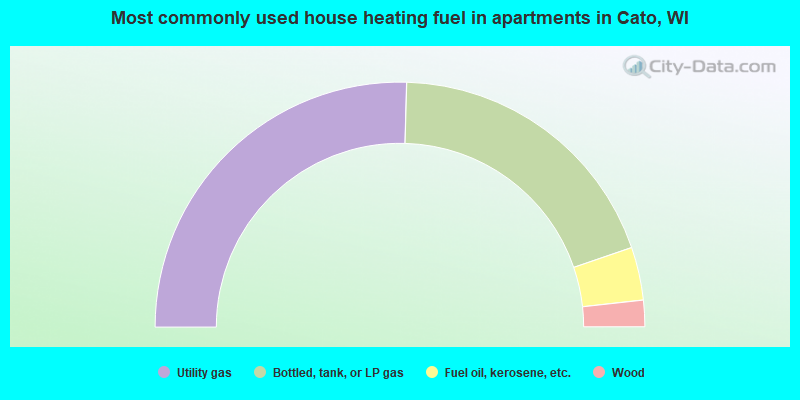
- 50.9%Utility gas
- 38.6%Bottled, tank, or LP gas
- 7.0%Fuel oil, kerosene, etc.
- 3.5%Wood
Cato compared to Wisconsin state average:
- Unemployed percentage significantly below state average.
- Black race population percentage significantly below state average.
- Hispanic race population percentage significantly below state average.
- Foreign-born population percentage significantly below state average.
- Renting percentage significantly below state average.
- Length of stay since moving in significantly above state average.
- Number of rooms per house significantly below state average.
- House age significantly below state average.

|
Total of 15 patent applications in 2008-2024.