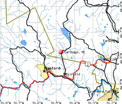
Carthage, Maine
Submit your own pictures of this town and show them to the world
- OSM Map
- General Map
- Google Map
- MSN Map
Population change since 2000: +7.7%
 |
| Males: 300 | |
| Females: 260 |
| Median resident age: | 44.2 years |
| Maine median age: | 43.0 years |
Zip codes: 04224.
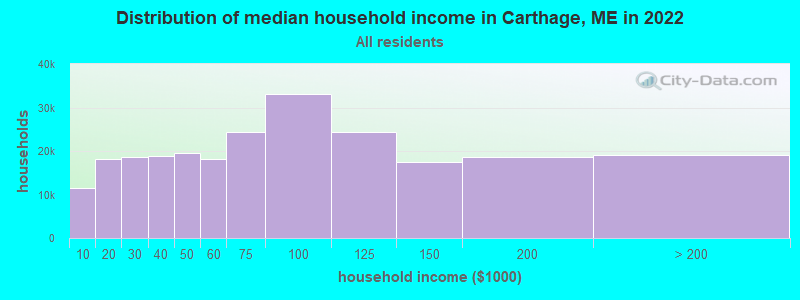
| Carthage: | $54,860 |
| ME: | $69,543 |
Estimated per capita income in 2022: $26,492 (it was $12,169 in 2000)
Carthage town income, earnings, and wages data
Estimated median house or condo value in 2022: $170,402 (it was $64,200 in 2000)
| Carthage: | $170,402 |
| ME: | $290,600 |
Mean prices in 2022: all housing units: $249,382; detached houses: $272,823; townhouses or other attached units: $269,365; in 2-unit structures: $215,792; in 3-to-4-unit structures: $159,774; in 5-or-more-unit structures: $237,338; mobile homes: $71,957
Detailed information about poverty and poor residents in Carthage, ME


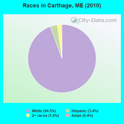
- 52994.5%White alone
- 193.4%Hispanic
- 101.8%Two or more races
- 20.4%Asian alone
Races in Carthage detailed stats: ancestries, foreign born residents, place of birth
According to our research of Maine and other state lists, there were 2 registered sex offenders living in Carthage, Maine as of May 08, 2024.
The ratio of all residents to sex offenders in Carthage is 280 to 1.
 Recent articles from our blog. Our writers, many of them Ph.D. graduates or candidates, create easy-to-read articles on a wide variety of topics.

 | Most Livable State in the U.S.A. Is... (31 replies) |
Latest news from Carthage, ME collected exclusively by city-data.com from local newspapers, TV, and radio stations
Ancestries: English (48.7%), Irish (12.7%), French (12.3%), Scottish (9.2%), German (5.4%), Scotch-Irish (2.9%).
Current Local Time: EST time zone
Incorporated on 02/20/1826
Elevation: 457 feet
Land area: 33.2 square miles.
Population density: 17 people per square mile (very low).
3 residents are foreign born
| This town: | 0.6% |
| Maine: | 2.9% |
| Carthage town: | 1.0% ($633) |
| Maine: | 1.5% ($1,417) |
Nearest city with pop. 50,000+: Portland, ME  (66.3 miles , pop. 64,249).
Nearest city with pop. 200,000+: Boston, MA (162.0 miles , pop. 589,141).
Nearest city with pop. 1,000,000+: Bronx, NY (313.7 miles , pop. 1,332,650).
Nearest cities:
), ), ), Latitude: 44.62 N, Longitude: 70.44 W
Area code commonly used in this area: 207

| Here: | 5.5% |
| Maine: | 3.4% |
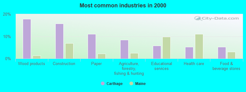
- Wood products (17.8%)
- Construction (15.7%)
- Paper (11.0%)
- Agriculture, forestry, fishing & hunting (8.4%)
- Educational services (5.8%)
- Health care (5.2%)
- Food & beverage stores (5.2%)
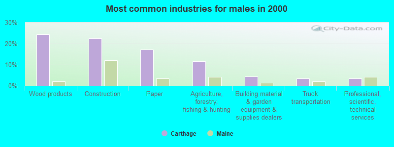
- Wood products (24.3%)
- Construction (22.5%)
- Paper (17.1%)
- Agriculture, forestry, fishing & hunting (11.7%)
- Building material & garden equipment & supplies dealers (4.5%)
- Truck transportation (3.6%)
- Professional, scientific, technical services (3.6%)
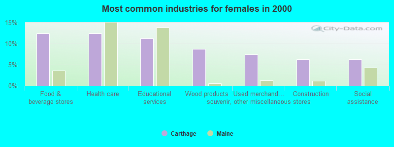
- Food & beverage stores (12.5%)
- Health care (12.5%)
- Educational services (11.2%)
- Wood products (8.8%)
- Used merchandise, gift, novelty, souvenir, other miscellaneous stores (7.5%)
- Construction (6.2%)
- Social assistance (6.2%)
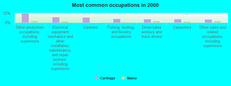
- Other production occupations, including supervisors (12.0%)
- Electrical equipment mechanics and other installation, maintenance, and repair workers, including supervisors (7.3%)
- Cashiers (6.8%)
- Fishing, hunting, and forestry occupations (5.2%)
- Driver/sales workers and truck drivers (4.7%)
- Carpenters (4.7%)
- Other sales and related occupations, including supervisors (4.2%)
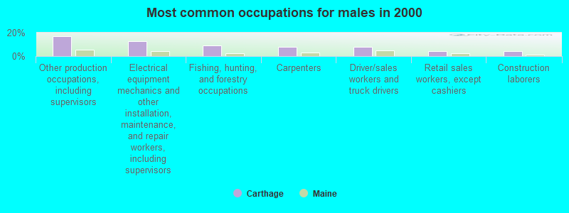
- Other production occupations, including supervisors (17.1%)
- Electrical equipment mechanics and other installation, maintenance, and repair workers, including supervisors (12.6%)
- Fishing, hunting, and forestry occupations (9.0%)
- Carpenters (8.1%)
- Driver/sales workers and truck drivers (8.1%)
- Retail sales workers, except cashiers (4.5%)
- Construction laborers (4.5%)
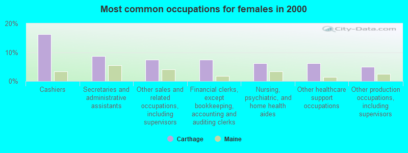
- Cashiers (16.2%)
- Secretaries and administrative assistants (8.8%)
- Other sales and related occupations, including supervisors (7.5%)
- Financial clerks, except bookkeeping, accounting and auditing clerks (7.5%)
- Nursing, psychiatric, and home health aides (6.2%)
- Other healthcare support occupations (6.2%)
- Other production occupations, including supervisors (5.0%)
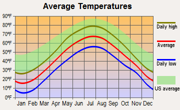
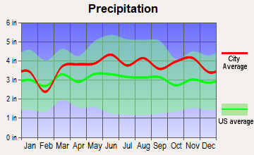
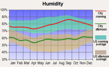
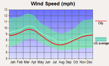
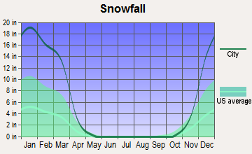
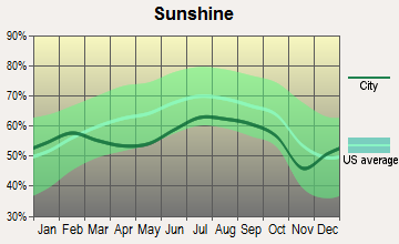
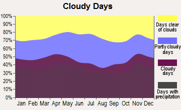
Average climate in Carthage, Maine
Based on data reported by over 4,000 weather stations
(lower is better)
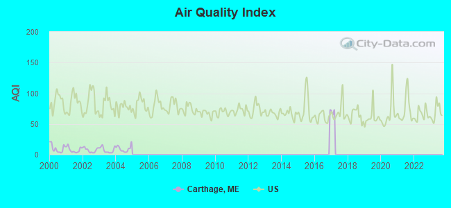
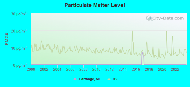
Air Quality Index (AQI) level in 2004 was 9.46. This is significantly better than average.
| City: | 9.46 |
| U.S.: | 72.56 |
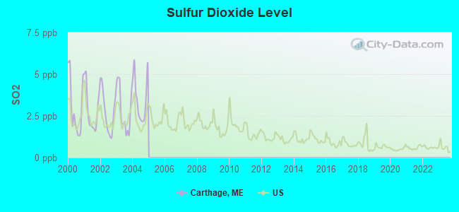
Sulfur Dioxide (SO2) [ppb] level in 2004 was 3.52. This is significantly worse than average. Closest monitor was 6.0 miles away from the city center.
| City: | 3.52 |
| U.S.: | 1.51 |
Earthquake activity:
Carthage-area historical earthquake activity is significantly above Maine state average. It is 76% smaller than the overall U.S. average.On 4/20/2002 at 10:50:47, a magnitude 5.3 (5.3 ML, Depth: 3.0 mi, Class: Moderate, Intensity: VI - VII) earthquake occurred 160.8 miles away from the city center
On 4/20/2002 at 10:50:47, a magnitude 5.2 (5.2 MB, 4.2 MS, 5.2 MW, 5.0 MW) earthquake occurred 162.0 miles away from Carthage center
On 10/16/2012 at 23:12:25, a magnitude 4.7 (4.7 ML, Depth: 10.0 mi, Class: Light, Intensity: IV - V) earthquake occurred 71.3 miles away from the city center
On 10/7/1983 at 10:18:46, a magnitude 5.3 (5.1 MB, 5.3 LG, 5.1 ML) earthquake occurred 198.7 miles away from Carthage center
On 1/19/1982 at 00:14:42, a magnitude 4.7 (4.5 MB, 4.7 MD, 4.5 LG) earthquake occurred 96.4 miles away from Carthage center
On 1/17/2000 at 08:16:20, a magnitude 3.6 (3.6 MB, Depth: 10.1 mi, Class: Light, Intensity: II - III) earthquake occurred 3.2 miles away from Carthage center
Magnitude types: regional Lg-wave magnitude (LG), body-wave magnitude (MB), duration magnitude (MD), local magnitude (ML), surface-wave magnitude (MS), moment magnitude (MW)
Natural disasters:
The number of natural disasters in Franklin County (27) is a lot greater than the US average (15).Major Disasters (Presidential) Declared: 19
Emergencies Declared: 7
Causes of natural disasters: Floods: 16, Storms: 14, Snows: 7, Heavy Rains: 2, Hurricanes: 2, Blizzard: 1, Ice Storm: 1, Landslide: 1, Snowfall: 1, Tropical Storm: 1, Wind: 1, Winter Storm: 1, Other: 2 (Note: some incidents may be assigned to more than one category).
Hospitals and medical centers near Carthage:
- DIXFIELD HEALTH CARE CENTER (Nursing Home, about 6 miles away; DIXFIELD, ME)
- RUMFORD HOSPITAL Critical Access Hospitals (about 8 miles away; RUMFORD, ME)
- VICTORIAN VILLA NURSING HOME (Nursing Home, about 14 miles away; CANTON, ME)
- SANDY RIVER CENTER (Nursing Home, about 14 miles away; FARMINGTON, ME)
- EDGEWOOD REHAB AND LIVING CTR (Nursing Home, about 15 miles away; FARMINGTON, ME)
- ORCHARD PARK REHAB AND LIVING (Nursing Home, about 15 miles away; FARMINGTON, ME)
Colleges/universities with over 2000 students nearest to Carthage:
- University of Maine at Farmington (about 15 miles; Farmington, ME; Full-time enrollment: 2,036)
- University of Maine at Augusta (about 37 miles; Augusta, ME; FT enrollment: 3,204)
- Saint Joseph's College of Maine (about 55 miles; Standish, ME; FT enrollment: 2,010)
- University of Southern Maine (about 67 miles; Portland, ME; FT enrollment: 6,647)
- Southern Maine Community College (about 68 miles; South Portland, ME; FT enrollment: 4,666)
- University of New England (about 81 miles; Biddeford, ME; FT enrollment: 4,539)
- Husson University (about 83 miles; Bangor, ME; FT enrollment: 2,421)
Points of interest:
Notable location: Carthage Volunteer Fire Department (A). Display/hide its location on the map
Cemeteries: Newman Cemetery (1), Berry Mills Cemetery (2). Display/hide their locations on the map
Lakes: Halfmoon Pond (A), Podunk Pond (B). Display/hide their locations on the map
Streams, rivers, and creeks: Hanscom Brook (A), Lapham Brook (B), Green Brook (C), Durgin Brook (D), Dunning Brook (E), Hutchinson Brook (F), Kittredge Brook (G), Berry Brook (H), Basin Brook (I). Display/hide their locations on the map
| This town: | 2.5 people |
| Maine: | 2.3 people |
| This town: | 64.6% |
| Whole state: | 62.9% |
| This town: | 13.5% |
| Whole state: | 9.4% |
Likely homosexual households (counted as self-reported same-sex unmarried-partner households)
- Lesbian couples: 0.4% of all households
- Gay men: 1.3% of all households
| This town: | 12.8% |
| Whole state: | 10.9% |
| This town: | 5.3% |
| Whole state: | 4.1% |
For population 15 years and over in Carthage:
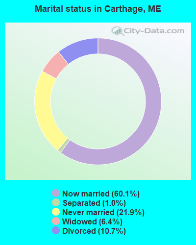
- Never married: 21.9%
- Now married: 60.1%
- Separated: 1.0%
- Widowed: 6.4%
- Divorced: 10.7%
For population 25 years and over in Carthage:
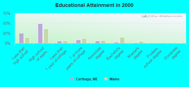
- High school or higher: 74.7%
- Bachelor's degree or higher: 4.3%
- Graduate or professional degree: 1.1%
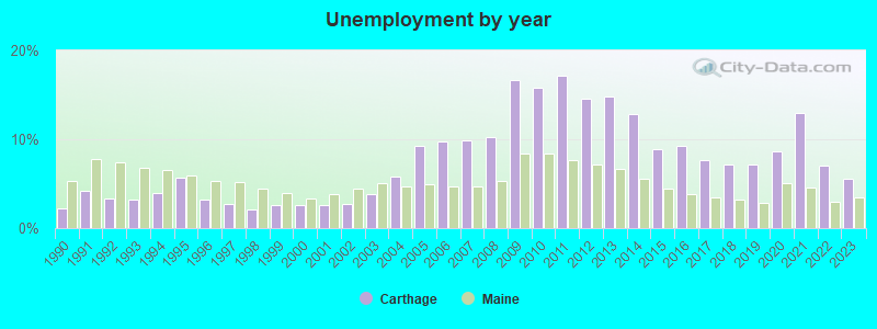
- Unemployed: 11.2%
- Mean travel time to work (commute): 26.6 minutes
| Here: | 9.2 |
| Maine average: | 11.2 |
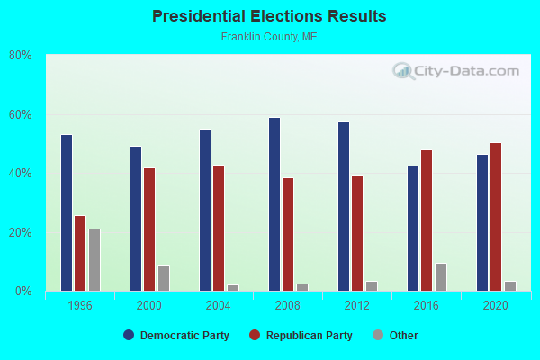
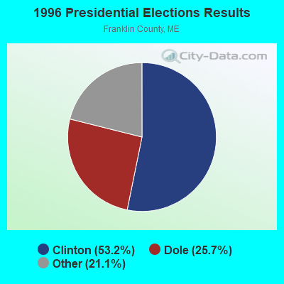
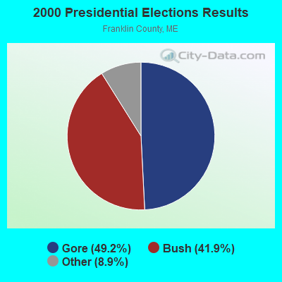
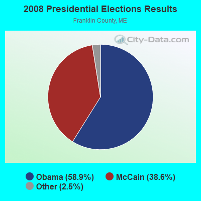
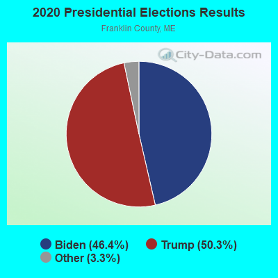
Graphs represent county-level data. Detailed 2008 Election Results
Religion statistics for Carthage, ME (based on Franklin County data)
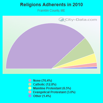
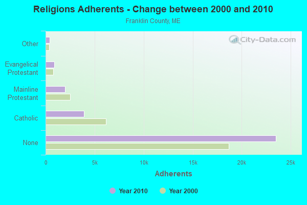
| Religion | Adherents | Congregations |
|---|---|---|
| Catholic | 3,936 | 5 |
| Mainline Protestant | 2,003 | 21 |
| Evangelical Protestant | 908 | 16 |
| Other | 427 | 2 |
| None | 23,494 | - |
Food Environment Statistics:
| This county: | 4.68 / 10,000 pop. |
| Maine: | 2.80 / 10,000 pop. |
| Franklin County: | 0.33 / 10,000 pop. |
| Maine: | 0.14 / 10,000 pop. |
| Here: | 3.01 / 10,000 pop. |
| Maine: | 2.20 / 10,000 pop. |
| Here: | 6.69 / 10,000 pop. |
| State: | 5.75 / 10,000 pop. |
| Franklin County: | 14.38 / 10,000 pop. |
| Maine: | 11.02 / 10,000 pop. |
| This county: | 7.3% |
| Maine: | 8.2% |
| Franklin County: | 24.4% |
| Maine: | 25.0% |
Strongest AM radio stations in Carthage:
- WTME (780 AM; 10 kW; RUMFORD, ME; Owner: MOUNTAIN VALLEY BROADCASTING, INC.)
- WSKW (1160 AM; 10 kW; SKOWHEGAN, ME; Owner: MOUNTAIN WIRELESS, INCORPORATED)
- WRKO (680 AM; 50 kW; BOSTON, MA; Owner: ENTERCOM BOSTON LICENSE, LLC)
- WMTW (870 AM; 10 kW; GORHAM, ME; Owner: RADIO PARTNERS OF MAINE, L.P.)
- WFAU (1280 AM; 5 kW; GARDINER, ME; Owner: CAPSTAR TX LIMITED PARTNERSHIP)
- WLAM (1470 AM; 5 kW; LEWISTON, ME; Owner: RADIO PARTNERS OF MAINE, L.P.)
- WEEI (850 AM; 50 kW; BOSTON, MA; Owner: ENTERCOM BOSTON LICENSE, LLC)
- WCHP (760 AM; 35 kW; CHAMPLAIN, NY; Owner: CHAMPLAIN RADIO, INC.)
- WGAN (560 AM; 5 kW; PORTLAND, ME; Owner: SAGA COMMUNICATIONS OF NEW ENGLAND, LLC)
- WBZ (1030 AM; 50 kW; BOSTON, MA; Owner: INFINITY BROADCASTING OPERATIONS, INC.)
- WCRN (830 AM; 50 kW; WORCESTER, MA; Owner: CARTER BROADCASTING CORPORATION)
- WNNZ (640 AM; 50 kW; WESTFIELD, MA; Owner: CLEAR CHANNEL BROADCASTING LICENSES, INC.)
- WKOX (1200 AM; 50 kW; FRAMINGHAM, MA; Owner: CAPSTAR TX LIMITED PARTNERSHIP)
Strongest FM radio stations in Carthage:
- WLOB-FM (96.3 FM; RUMFORD, ME; Owner: ATLANTIC COAST RADIO, LLC)
- WTBM (100.7 FM; MEXICO, ME; Owner: MOUNTAIN VALLEY BROADCASTING, INC.)
- WTOS-FM (105.1 FM; SKOWHEGAN, ME; Owner: CAPSTAR TX LIMITED PARTNERSHIP)
- WPKQ (103.7 FM; NORTH CONWAY, NH; Owner: CITADEL BROADCASTING COMPANY)
- WHOM (94.9 FM; MT. WASHINGTON, NH; Owner: CITADEL BROADCASTING COMPANY)
- WKTJ-FM (99.3 FM; FARMINGTON, ME; Owner: FRANKLIN BROADCASTING CORPORATION)
- WMEA (90.1 FM; PORTLAND, ME; Owner: MAINE PUBLIC BROADCASTING CORPORATION)
- WBLM (102.9 FM; PORTLAND, ME; Owner: CITADEL BROADCASTING COMPANY)
- WHQO (107.9 FM; SKOWHEGAN, ME; Owner: MOUNTAIN WIRELESS, INC.)
TV broadcast stations around Carthage:
- W21BI (Channel 21; FARMINGTON, ME; Owner: TRINITY BROADCASTING NETWORK)
- WGME-TV (Channel 13; PORTLAND, ME; Owner: WGME LICENSEE, LLC)
- WMTW-TV (Channel 8; POLAND SPRING, ME; Owner: WMTW BROADCAST GROUP, LLC)
- National Bridge Inventory (NBI) Statistics
- 4Number of bridges
- 26ft / 8.3mTotal length
- 5,286Total average daily traffic
- 262Total average daily truck traffic
- 7,572Total future (year 2036) average daily traffic
FCC Registered Microwave Towers:
1- Carthage, Web River Mountain Estates (Off Route 142) (Lat: 44.615417 Lon: -70.461611), Type: Ltower, Structure height: 58.2 m, Overall height: 59.4 m, Call Sign: WQSC966,
Assigned Frequencies: 10735.0 MHz, 10735.0 MHz, 10735.0 MHz, 10735.0 MHz, 10735.0 MHz, 10735.0 MHz, 10735.0 MHz, 10735.0 MHz, 10735.0 MHz, Grant Date: 09/04/2013, Expiration Date: 09/04/2023, Cancellation Date: 04/15/2020, Certifier: Jessica B Lyons, Registrant: At&t Services, Inc., 208 S. Akard Street, Room 2100, Dallas, TX 75202, Phone: (855) 699-7073, Email:
FCC Registered Amateur Radio Licenses:
1- Call Sign: KB1HQR, Licensee ID: L00438329, Grant Date: 11/29/2011, Expiration Date: 12/21/2021, Cancellation Date: 12/22/2023, Certifier: James P Marion, Registrant: James P Marion, 36 Tainter Corner Road, Carthage, ME 04224
Carthage compared to Maine state average:
- Median house value below state average.
- Black race population percentage significantly below state average.
- Hispanic race population percentage above state average.
- Foreign-born population percentage significantly below state average.
- Renting percentage below state average.
- Length of stay since moving in significantly above state average.
- Number of rooms per house significantly below state average.
- House age significantly below state average.
- Number of college students below state average.
- Percentage of population with a bachelor's degree or higher significantly below state average.