Canton, Massachusetts
Submit your own pictures of this town and show them to the world
- OSM Map
- General Map
- Google Map
- MSN Map
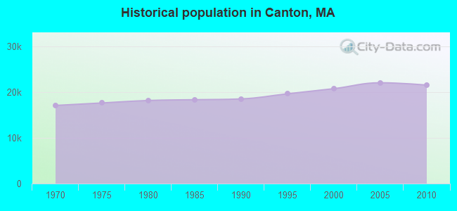
Population change since 2000: +3.8%
 |
| Males: 10,198 | |
| Females: 11,363 |
| Median resident age: | 42.3 years |
| Massachusetts median age: | 39.2 years |
Zip codes: 02021.
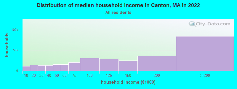
| Canton: | $126,624 |
| MA: | $94,488 |
Estimated per capita income in 2022: $68,256 (it was $33,510 in 2000)
Canton town income, earnings, and wages data
Estimated median house or condo value in 2022: $730,544 (it was $254,400 in 2000)
| Canton: | $730,544 |
| MA: | $534,700 |
Mean prices in 2022: all housing units: $811,449; detached houses: $851,375; townhouses or other attached units: $650,242; in 2-unit structures: $825,093; in 3-to-4-unit structures: $853,292; in 5-or-more-unit structures: $584,259; mobile homes: $91,001
Detailed information about poverty and poor residents in Canton, MA


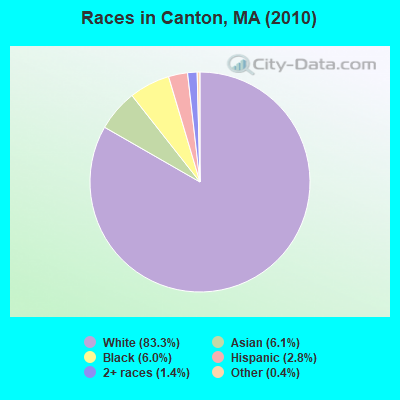
- 17,95183.3%White alone
- 1,3126.1%Asian alone
- 1,3016.0%Black alone
- 5962.8%Hispanic
- 3021.4%Two or more races
- 810.4%Other race alone
- 170.08%American Indian alone
Races in Canton detailed stats: ancestries, foreign born residents, place of birth
According to our research of Massachusetts and other state lists, there was 1 registered sex offender living in Canton, Massachusetts as of May 06, 2024.
The ratio of all residents to sex offenders in Canton is 21,561 to 1.
The ratio of registered sex offenders to all residents in this city is much lower than the state average.
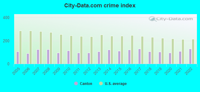
Type |
2009 |
2010 |
2011 |
2012 |
2013 |
2014 |
2015 |
2016 |
2017 |
2018 |
2019 |
2020 |
2021 |
2022 |
|---|---|---|---|---|---|---|---|---|---|---|---|---|---|---|
| Murders (per 100,000) | 0 (0.0) | 0 (0.0) | 0 (0.0) | 0 (0.0) | 0 (0.0) | 0 (0.0) | 0 (0.0) | 0 (0.0) | 0 (0.0) | 0 (0.0) | 0 (0.0) | 0 (0.0) | 0 (0.0) | 0 (0.0) |
| Rapes (per 100,000) | 2 (8.9) | 3 (13.9) | 0 (0.0) | 1 (4.6) | 3 (13.6) | 7 (31.2) | 4 (17.6) | 5 (21.8) | 8 (34.0) | 4 (16.9) | 0 (0.0) | 2 (8.3) | 8 (32.6) | 7 (28.3) |
| Robberies (per 100,000) | 5 (22.3) | 4 (18.6) | 4 (18.4) | 5 (22.8) | 7 (31.7) | 1 (4.5) | 2 (8.8) | 4 (17.4) | 8 (34.0) | 4 (16.9) | 5 (21.1) | 3 (12.5) | 3 (12.2) | 1 (4.0) |
| Assaults (per 100,000) | 38 (169.6) | 45 (208.7) | 22 (101.4) | 29 (132.4) | 49 (221.7) | 51 (227.3) | 60 (263.8) | 69 (300.5) | 74 (314.2) | 75 (316.3) | 80 (337.5) | 69 (287.3) | 64 (260.5) | 91 (368.2) |
| Burglaries (per 100,000) | 44 (196.4) | 67 (310.7) | 75 (345.7) | 50 (228.3) | 43 (194.6) | 55 (245.1) | 48 (211.0) | 27 (117.6) | 22 (93.4) | 9 (38.0) | 18 (75.9) | 12 (50.0) | 11 (44.8) | 11 (44.5) |
| Thefts (per 100,000) | 164 (731.9) | 150 (695.7) | 210 (968.1) | 185 (844.6) | 140 (633.5) | 160 (713.0) | 130 (571.5) | 156 (679.4) | 123 (522.3) | 98 (413.3) | 132 (556.8) | 115 (478.9) | 120 (488.4) | 145 (586.6) |
| Auto thefts (per 100,000) | 15 (66.9) | 13 (60.3) | 16 (73.8) | 24 (109.6) | 5 (22.6) | 11 (49.0) | 10 (44.0) | 15 (65.3) | 5 (21.2) | 13 (54.8) | 7 (29.5) | 14 (58.3) | 10 (40.7) | 14 (56.6) |
| Arson (per 100,000) | 0 (0.0) | 0 (0.0) | 2 (9.2) | 1 (4.6) | 1 (4.5) | 2 (8.9) | 0 (0.0) | 1 (4.4) | 0 (0.0) | 1 (4.2) | 1 (4.2) | 0 (0.0) | 0 (0.0) | 2 (8.1) |
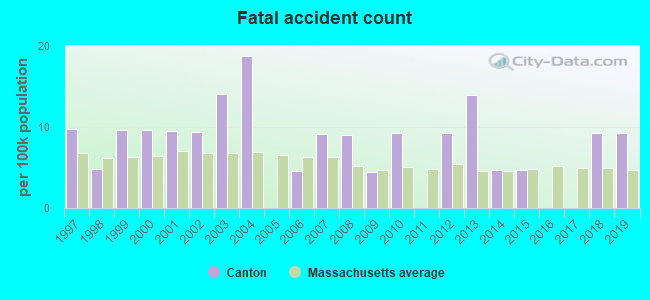
| City-Data.com crime index | 96.1 | 112.8 | 94.6 | 95.5 | 105.5 | 121.3 | 110.6 | 123.4 | 129.3 | 105.4 | 103.8 | 95.2 | 107.7 | 128.6 |
The City-Data.com crime index weighs serious crimes and violent crimes more heavily. Higher means more crime, U.S. average is 246.1. It adjusts for the number of visitors and daily workers commuting into cities.
Crime rate in Canton detailed stats: murders, rapes, robberies, assaults, burglaries, thefts, arson
Full-time law enforcement employees in 2021, including police officers: 45 (45 officers - 39 male; 6 female).
| Officers per 1,000 residents here: | 1.83 |
| Massachusetts average: | 2.53 |
 Recent articles from our blog. Our writers, many of them Ph.D. graduates or candidates, create easy-to-read articles on a wide variety of topics.

 | Beverly vs. Canton? (13 replies) |
| 2021 Real Estate Observations (1729 replies) |
| Canton vs Westwood vs Sharon schools (3 replies) |
| "All-Inclusive Boston" campaiagn (582 replies) |
| Like he** I'm going to pay these prices! (684 replies) |
| Other options? Canton, Milton, Hingham, Walpole? (6 replies) |
Latest news from Canton, MA collected exclusively by city-data.com from local newspapers, TV, and radio stations
Ancestries: Irish (33.1%), Italian (17.3%), English (9.9%), German (6.2%), Polish (4.3%), United States (4.0%).
Current Local Time: EST time zone
Incorporated in 1797
Elevation: 100 feet
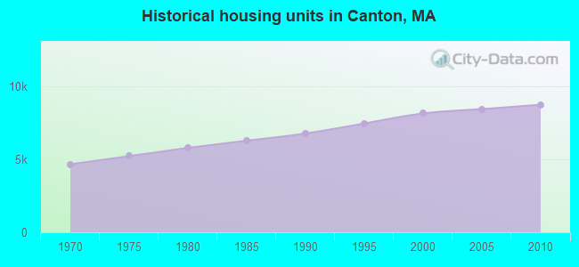
Land area: 18.9 square miles.
Population density: 1,139 people per square mile (low).
1,791 residents are foreign born (4.8% Europe, 2.2% Asia).
| This town: | 8.6% |
| Massachusetts: | 12.2% |
| Canton town: | 1.1% ($2,780) |
| Massachusetts: | 1.3% ($2,336) |
Nearest city with pop. 50,000+: Brockton, MA  (8.0 miles , pop. 94,304).
Nearest city with pop. 200,000+: Boston, MA (11.0 miles , pop. 589,141).
Nearest city with pop. 1,000,000+: Bronx, NY (168.8 miles , pop. 1,332,650).
Nearest cities:
), ), ), Latitude: 42.17 N, Longitude: 71.13 W
Area codes: 781, 339

Canton, Massachusetts accommodation & food services, waste management - Economy and Business Data
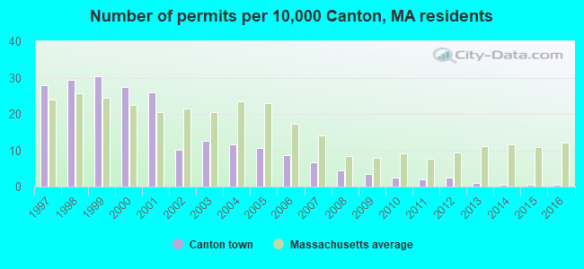
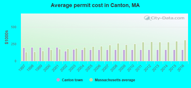
Single-family new house construction building permits:
- 2016: 1 building, cost: $167,400
- 2015: 1 building, cost: $167,400
- 2014: 1 building, cost: $167,400
- 2013: 2 buildings, average cost: $167,400
- 2012: 5 buildings, average cost: $167,400
- 2011: 4 buildings, average cost: $167,400
- 2010: 5 buildings, average cost: $167,400
- 2009: 7 buildings, average cost: $167,400
- 2008: 9 buildings, average cost: $167,400
- 2007: 14 buildings, average cost: $167,400
- 2006: 18 buildings, average cost: $167,300
- 2005: 22 buildings, average cost: $167,500
- 2004: 24 buildings, average cost: $166,800
- 2003: 26 buildings, average cost: $170,700
- 2002: 21 buildings, average cost: $147,500
- 2001: 54 buildings, average cost: $202,300
- 2000: 57 buildings, average cost: $202,300
- 1999: 63 buildings, average cost: $202,200
- 1998: 61 buildings, average cost: $203,100
- 1997: 58 buildings, average cost: $198,500
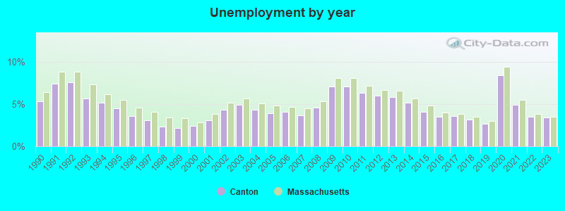
| Here: | 3.4% |
| Massachusetts: | 3.5% |
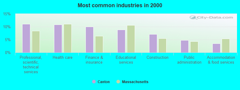
- Professional, scientific, technical services (11.0%)
- Health care (10.8%)
- Finance & insurance (10.0%)
- Educational services (8.8%)
- Construction (7.1%)
- Public administration (4.8%)
- Accommodation & food services (3.4%)
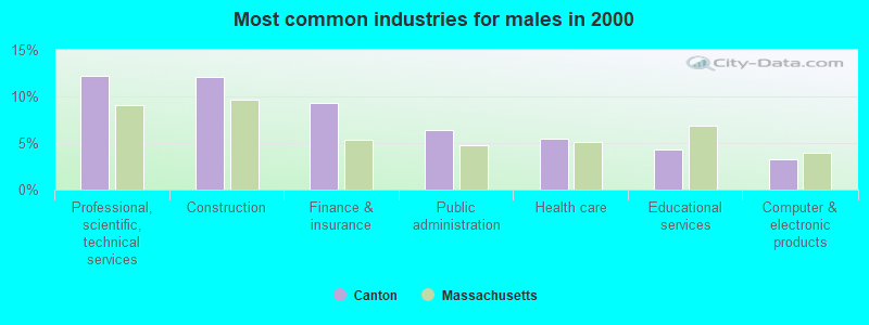
- Professional, scientific, technical services (12.2%)
- Construction (12.1%)
- Finance & insurance (9.3%)
- Public administration (6.3%)
- Health care (5.5%)
- Educational services (4.4%)
- Computer & electronic products (3.3%)
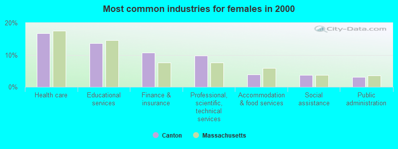
- Health care (16.7%)
- Educational services (13.7%)
- Finance & insurance (10.7%)
- Professional, scientific, technical services (9.7%)
- Accommodation & food services (3.9%)
- Social assistance (3.8%)
- Public administration (3.0%)
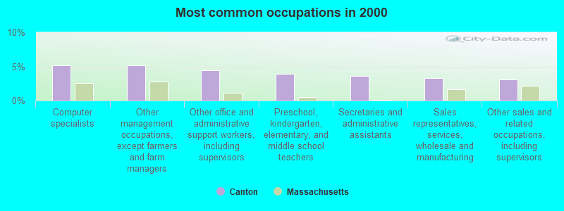
- Computer specialists (5.2%)
- Other management occupations, except farmers and farm managers (5.1%)
- Other office and administrative support workers, including supervisors (4.4%)
- Preschool, kindergarten, elementary, and middle school teachers (3.9%)
- Secretaries and administrative assistants (3.6%)
- Sales representatives, services, wholesale and manufacturing (3.3%)
- Other sales and related occupations, including supervisors (3.1%)
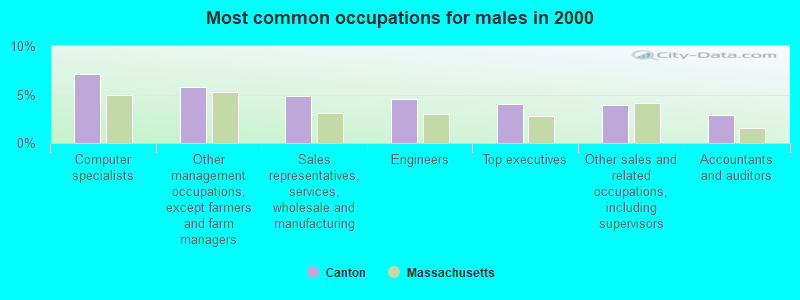
- Computer specialists (7.1%)
- Other management occupations, except farmers and farm managers (5.7%)
- Sales representatives, services, wholesale and manufacturing (4.8%)
- Engineers (4.6%)
- Top executives (4.1%)
- Other sales and related occupations, including supervisors (3.9%)
- Accountants and auditors (2.9%)
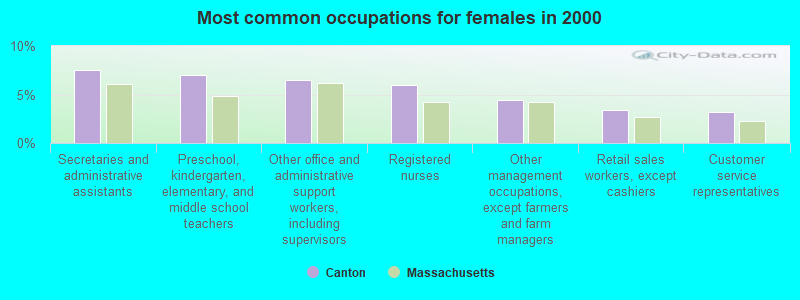
- Secretaries and administrative assistants (7.5%)
- Preschool, kindergarten, elementary, and middle school teachers (7.0%)
- Other office and administrative support workers, including supervisors (6.5%)
- Registered nurses (6.0%)
- Other management occupations, except farmers and farm managers (4.4%)
- Retail sales workers, except cashiers (3.4%)
- Customer service representatives (3.2%)
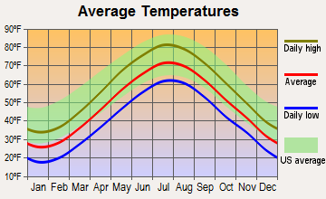
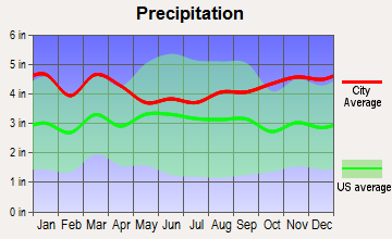
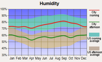
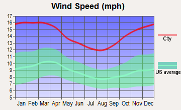
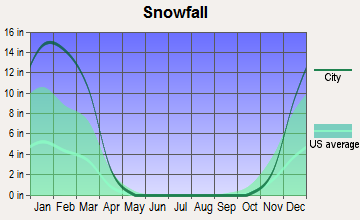
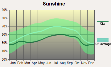
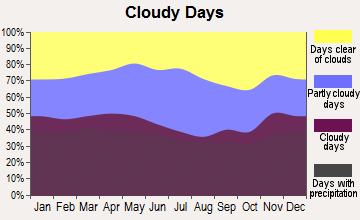
Average climate in Canton, Massachusetts
Based on data reported by over 4,000 weather stations
(lower is better)
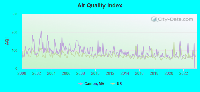
Air Quality Index (AQI) level in 2022 was 74.4. This is about average.
| City: | 74.4 |
| U.S.: | 72.6 |
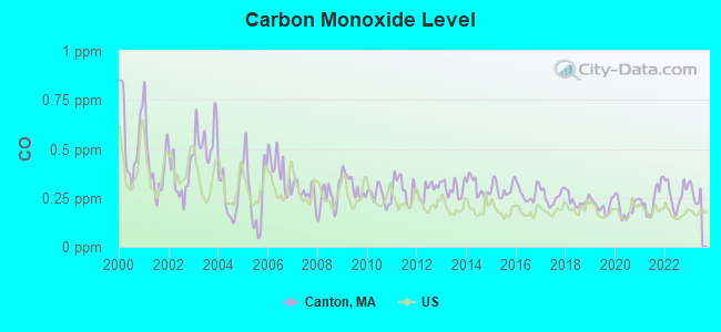
Carbon Monoxide (CO) [ppm] level in 2022 was 0.267. This is about average. Closest monitor was 9.8 miles away from the city center.
| City: | 0.267 |
| U.S.: | 0.251 |
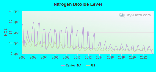
Nitrogen Dioxide (NO2) [ppb] level in 2022 was 4.20. This is better than average. Closest monitor was 3.3 miles away from the city center.
| City: | 4.20 |
| U.S.: | 5.11 |
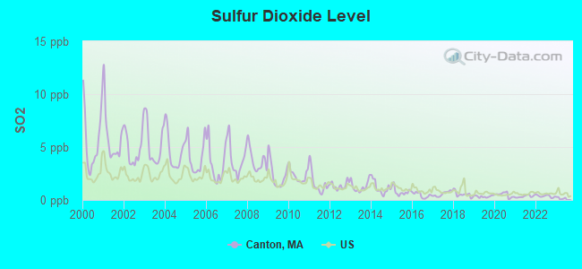
Sulfur Dioxide (SO2) [ppb] level in 2022 was 0.358. This is significantly better than average. Closest monitor was 3.8 miles away from the city center.
| City: | 0.358 |
| U.S.: | 1.515 |
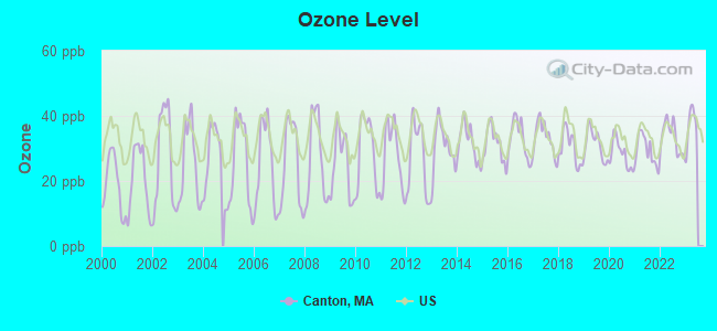
Ozone [ppb] level in 2022 was 33.4. This is about average. Closest monitor was 3.3 miles away from the city center.
| City: | 33.4 |
| U.S.: | 33.3 |
Particulate Matter (PM2.5) [µg/m3] level in 2022 was 7.11. This is about average. Closest monitor was 3.3 miles away from the city center.
| City: | 7.11 |
| U.S.: | 8.11 |
Tornado activity:
Canton-area historical tornado activity is slightly below Massachusetts state average. It is 47% smaller than the overall U.S. average.
On 6/9/1953, a category F4 (max. wind speeds 207-260 mph) tornado 22.0 miles away from the Canton town center killed 90 people and injured 1228 people and caused between $50,000,000 and $500,000,000 in damages.
On 6/9/1953, a category F3 (max. wind speeds 158-206 mph) tornado 8.7 miles away from the town center injured 17 people and caused between $500,000 and $5,000,000 in damages.
Earthquake activity:
Canton-area historical earthquake activity is significantly above Massachusetts state average. It is 74% smaller than the overall U.S. average.On 10/7/1983 at 10:18:46, a magnitude 5.3 (5.1 MB, 5.3 LG, 5.1 ML, Class: Moderate, Intensity: VI - VII) earthquake occurred 204.0 miles away from the city center
On 4/20/2002 at 10:50:47, a magnitude 5.3 (5.3 ML, Depth: 3.0 mi) earthquake occurred 207.4 miles away from the city center
On 1/19/1982 at 00:14:42, a magnitude 4.7 (4.5 MB, 4.7 MD, 4.5 LG, Class: Light, Intensity: IV - V) earthquake occurred 95.3 miles away from the city center
On 10/16/2012 at 23:12:25, a magnitude 4.7 (4.7 ML, Depth: 10.0 mi) earthquake occurred 101.9 miles away from Canton center
On 4/20/2002 at 10:50:47, a magnitude 5.2 (5.2 MB, 4.2 MS, 5.2 MW, 5.0 MW) earthquake occurred 206.7 miles away from the city center
On 8/22/1992 at 12:20:32, a magnitude 4.8 (4.8 MB, 3.8 MS, 4.7 LG, Depth: 6.2 mi) earthquake occurred 215.8 miles away from Canton center
Magnitude types: regional Lg-wave magnitude (LG), body-wave magnitude (MB), duration magnitude (MD), local magnitude (ML), surface-wave magnitude (MS), moment magnitude (MW)
Natural disasters:
The number of natural disasters in Norfolk County (31) is a lot greater than the US average (15).Major Disasters (Presidential) Declared: 18
Emergencies Declared: 13
Causes of natural disasters: Floods: 12, Storms: 10, Hurricanes: 6, Snowstorms: 5, Snows: 3, Winter Storms: 3, Blizzards: 2, Explosion: 1, Heavy Rain: 1, Snowfall: 1, Tropical Storm: 1, Water Main Break: 1, Wind: 1 (Note: some incidents may be assigned to more than one category).

Main business address for: REEBOK INTERNATIONAL LTD (RUBBER & PLASTICS FOOTWEAR), NETWORK ENGINES INC (SERVICES-PREPACKAGED SOFTWARE), TWEETER HOME ENTERTAINMENT GROUP INC (RETAIL-RADIO TV & CONSUMER ELECTRONICS STORES), PLYMOUTH RUBBER CO INC (FABRICATED RUBBER PRODUCTS, NEC), CASUAL MALE RETAIL GROUP INC (RETAIL-FAMILY CLOTHING STORES).
Hospitals and medical centers in Canton:
- MASSACHUSETTS HOSPITAL SCHOOL (3 RANDOLPH STREET)
- HEBREW SENIORLIFE - HOME HEALTH CARE (1 DEL POND DRIVE)
- COMMONS RESIDENCE AT ORCHARD COVE (1 DEL POND DRIVE)
- HELLENIC NH FOR THE AGED (601 SHERMAN ST)
- HELLENIC NURSING AND REHABILITATION CENTER (601 SHERMAN STREET)
- KINDRED NURSING AND REHABILITATION-TOWER HILL (ONE MEADOWBROOK WAY)
Amtrak stations near Canton:
- 4 miles: ROUTE 128 (WESTWOOD, UNIVERSITY AVE. & RTE. 128) . Services: ticket office, enclosed waiting area, public restrooms, public payphones, vending machines, paid short-term parking, taxi stand, public transit connection.
- 13 miles: BACK BAY (BOSTON, 145 DARTMOUTH ST.) . Services: ticket office, partially wheelchair accessible, enclosed waiting area, public restrooms, public payphones, vending machines, ATM, paid short-term parking, paid long-term parking, call for car rental service, taxi stand, public transit connection.
- 14 miles: BOSTON (SO. STA) (BOSTON, ATLANTIC AVE. & SUMMER ST.) . Services: ticket office, fully wheelchair accessible, enclosed waiting area, public restrooms, public payphones, full-service food facilities and snack bar, ATM, paid short-term parking, paid long-term parking, call for car rental service, taxi stand, intercity bus service, public transit connection.
Colleges/Universities in Canton:
- Bay State School of Technology (Full-time enrollment: 209; Location: 225 Turnpike St; Private, for-profit; Website: www.baystatetech.org)
- Blue Hills Regional Technical School (Full-time enrollment: 52; Location: 800 Randolph St; Public; Website: www.bluehills.org/postgraduate-practical-nursing-program/)
Colleges/universities with over 2000 students nearest to Canton:
- Curry College (about 6 miles; Milton, MA; Full-time enrollment: 2,586)
- Stonehill College (about 8 miles; Easton, MA; FT enrollment: 2,563)
- Quincy College (about 9 miles; Quincy, MA; FT enrollment: 3,184)
- Massasoit Community College (about 10 miles; Brockton, MA; FT enrollment: 5,442)
- University of Massachusetts-Boston (about 12 miles; Boston, MA; FT enrollment: 12,625)
- Babson College (about 12 miles; Wellesley, MA; FT enrollment: 3,230)
- MCPHS University (about 12 miles; Boston, MA; FT enrollment: 5,491)
Public high schools in Canton:
- CANTON HIGH (Students: 827, Location: 900 WASHINGTON STREET, Grades: 9-12)
- BLUE HILLS REGIONAL VOCATIONAL TECHNICAL (Location: 800 RANDOLPH STREET, Grades: 9-12)
Private high school in Canton:
Public elementary/middle schools in Canton:
- WM H GALVIN MIDDLE (Students: 737, Location: 55 PECUNIT STREET, Grades: 6-8)
- DEAN S LUCE (Students: 713, Location: 45 INDEPENDENCE ST, Grades: KG-5)
- LT PETER M HANSEN (Students: 431, Location: 25 PECUNIT STREET, Grades: KG-5)
- JOHN F KENNEDY (Students: 385, Location: 100 DEDHAM STREET, Grades: KG-5)
Private elementary/middle schools in Canton:
Library in Canton:
Points of interest:
Notable locations in Canton: Blue Hill Country Club (A), Cantion Junction Station (B), Canton Center Station (C), Camp Dorchester (D), Wampatuck Country Club (E), Canton Commerce Center (F), Pequtside Farm (G), Ponkapoag Golf Club (H), Shawmut Industrial Park (I), Rapid Ambulance Service (J), Canton Townhall (K), Canton Fire Department Station 2 (L), Canton Fire Department Station 1 Headquarters (M), Canton Historical Society Library (N), Canton Public Library (O), Massachusetts Hospital School Medical Library (P), Cobbs Tavern (Q). Display/hide their locations on the map
Shopping Centers: Star Market Shopping Center (1), Tri-Town Shopping Center (2), The Village Mall Shopping Center (3). Display/hide their locations on the map
Main business address in Canton include: REEBOK INTERNATIONAL LTD (A), NETWORK ENGINES INC (B), TWEETER HOME ENTERTAINMENT GROUP INC (C), PLYMOUTH RUBBER CO INC (D), CASUAL MALE RETAIL GROUP INC (E). Display/hide their locations on the map
Churches in Canton include: Saint James Lutheran Church (A), Saint Gerard Majella Church (B), First Parish Unitarian Church (C). Display/hide their locations on the map
Cemeteries: Canton Cemetery (1), Saint Marys Cemetery (2). Display/hide their locations on the map
Lakes and reservoirs: Glen Echo Pond (A), Muddy Pond (B), Ponkapoag Pond (C), Trowel Shop Pond (D), Bolivar Pond (E), Forge Pond (F), Reservoir Pond (G). Display/hide their locations on the map
Streams, rivers, and creeks: York Brook (A), Beaver Meadow Brook (B), Puffers Brook (C), Steep Hill Brook (D), East Branch Neponset River (E), Massapoag Brook (F), Pequid Brook (G), Purgatory Brook (H). Display/hide their locations on the map
Park in Canton: Memorial Field (1). Display/hide its location on the map
Tourist attractions: Irish Cultural Centre Inc (Cultural Attractions- Events- & Facilities; 200 New Boston Drive) (1), FootPlanes (15 Pecunit Street) (2). Display/hide their approximate locations on the map
Court: Norfolk County - Probate Court (35 Shawmut Road) (1). Display/hide its approximate location on the map
Birthplace of: Rob Mariano - Television personality, Bill Burr - Stand-up comedian, James B. Sumner - Chemist, Paul Guilfoyle - Film actor, Augustus Bradford Endicott - Politician, Stephen Schnetzer - Actor, Ben Ticknor - College football player, Steve Rooney - Ice hockey player.
Drinking water stations with addresses in Canton and their reported violations in the past:
CANTON WATER DEPT (Population served: 21,916, Purch surface water):Past health violations:COPPERWOOD II CONDOMINIUMS (Population served: 75, Groundwater):
- MCL, Monthly (TCR) - In AUG-2013, Contaminant: Coliform. Follow-up actions: St AO (w/o penalty) issued (NOV-29-2013), St Compliance achieved (NOV-29-2013)
- MCL, Monthly (TCR) - In NOV-2012, Contaminant: Coliform. Follow-up actions: St AO (w/o penalty) issued (NOV-30-2012), St Compliance achieved (JAN-28-2013)
- MCL, Monthly (TCR) - In SEP-2012, Contaminant: Coliform. Follow-up actions: St AO (w/o penalty) issued (NOV-30-2012), St Compliance achieved (JAN-28-2013)
- MCL, Monthly (TCR) - In AUG-2012, Contaminant: Coliform. Follow-up actions: St AO (w/o penalty) issued (NOV-30-2012), St Compliance achieved (JAN-28-2013)
- MCL, Monthly (TCR) - In JUL-2012, Contaminant: Coliform. Follow-up actions: St AO (w/o penalty) issued (NOV-30-2012), St Compliance achieved (JAN-28-2013)
- MCL, Monthly (TCR) - In JUN-2012, Contaminant: Coliform. Follow-up actions: St AO (w/o penalty) issued (AUG-31-2012), St Compliance achieved (AUG-31-2012)
- 3 other older health violations
Past health violations:Past monitoring violations:
- MCL, Monthly (TCR) - In NOV-2013, Contaminant: Coliform. Follow-up actions: St AO (w/o penalty) issued (NOV-29-2013)
- MCL, Acute (TCR) - In NOV-2013, Contaminant: Coliform. Follow-up actions: St AO (w/o penalty) issued (NOV-29-2013)
- MCL, Monthly (TCR) - In SEP-2013, Contaminant: Coliform. Follow-up actions: St AO (w/o penalty) issued (NOV-29-2013)
- MCL, Monthly (TCR) - In AUG-2013, Contaminant: Coliform. Follow-up actions: St AO (w/o penalty) issued (NOV-29-2013)
- MCL, Monthly (TCR) - In JUL-2013, Contaminant: Coliform. Follow-up actions: St AO (w/o penalty) issued (JUL-01-2013)
- MCL, Acute (TCR) - In JUL-2013, Contaminant: Coliform. Follow-up actions: St AO (w/o penalty) issued (JUL-01-2013)
- 21 other older health violations
- Monitoring, Repeat Major (TCR) - In OCT-2013, Contaminant: Coliform (TCR). Follow-up actions: St AO (w/o penalty) issued (NOV-29-2013)
- Notification, State - In JUN-2011, Contaminant: Coliform (TCR). Follow-up actions: St AO (w/o penalty) issued (AUG-31-2011), St Compliance achieved (JUL-10-2012)
- Follow-up Or Routine LCR Tap M/R - In OCT-01-2010, Contaminant: Lead and Copper Rule. Follow-up actions: St AO (w/o penalty) issued (NOV-30-2010), St Compliance achieved (MAR-14-2012)
- Monitoring, Repeat Major (TCR) - In JUN-2010, Contaminant: Coliform (TCR). Follow-up actions: St AO (w/o penalty) issued (AUG-30-2010), St Compliance achieved (JUL-10-2012)
- Follow-up Or Routine LCR Tap M/R - In OCT-01-2007, Contaminant: Lead and Copper Rule. Follow-up actions: St AO (w/o penalty) issued (NOV-14-2007), St Compliance achieved (MAR-06-2008)
- 53 regular monitoring violations
- 3 other older monitoring violations
Drinking water stations with addresses in Canton that have no violations reported:
- JOSEPH VIDETTA REALTY TRUST (Serves RI, Population served: 157, Primary Water Source Type: Groundwater)
| This town: | 2.5 people |
| Massachusetts: | 2.5 people |
| This town: | 68.2% |
| Whole state: | 63.0% |
| This town: | 4.1% |
| Whole state: | 7.0% |
Likely homosexual households (counted as self-reported same-sex unmarried-partner households)
- Lesbian couples: 0.4% of all households
- Gay men: 0.2% of all households
| This town: | 3.4% |
| Whole state: | 9.3% |
| This town: | 1.5% |
| Whole state: | 4.4% |
People in group quarters in Canton in 2010:
- 300 people in nursing facilities/skilled-nursing facilities
- 8 people in group homes intended for adults
- 6 people in group homes for juveniles (non-correctional)
- 4 people in other noninstitutional facilities
People in group quarters in Canton in 2000:
- 334 people in nursing homes
- 93 people in hospitals/wards and hospices for chronically ill
- 93 people in other hospitals or wards for chronically ill
- 12 people in homes for the mentally retarded
Banks with branches in Canton (2011 data):
- The Bank of Canton: Turnpike Street Branch, Washington St Branch, The Bank Of Canton. Info updated 2009/02/04: Bank assets: $634.2 mil, Deposits: $543.9 mil, local headquarters, positive income, Commercial Lending Specialization, 9 total offices, Holding Company: Ponkapoag Bancorp, Mhc
- TD Bank, National Association: Canton Branch at 95 Washington Street, branch established on 2005/12/12. Info updated 2010/10/04: Bank assets: $188,912.6 mil, Deposits: $153,149.8 mil, headquarters in Wilmington, DE, positive income, 1314 total offices, Holding Company: Toronto-Dominion Bank, The
- Canton Co-operative Bank: Canton Co-Operative Bank at 671 Washington Street, branch established on 1891/01/01. Info updated 2011/06/21: Bank assets: $101.4 mil, Deposits: $84.7 mil, local headquarters, positive income, Mortgage Lending Specialization, 1 total offices
- Sovereign Bank, National Association: Canton Shaws Supermarket Branch at 75 Washington Street, branch established on 2000/11/06. Info updated 2012/01/31: Bank assets: $78,146.9 mil, Deposits: $48,042.9 mil, headquarters in Wilmington, DE, positive income, Commercial Lending Specialization, 718 total offices, Holding Company: Banco Santander, S.A.
- Bank of America, National Association: Canton Branch at 710 Washington Street, branch established on 1814/01/01. Info updated 2009/11/18: Bank assets: $1,451,969.3 mil, Deposits: $1,077,176.8 mil, headquarters in Charlotte, NC, positive income, 5782 total offices, Holding Company: Bank Of America Corporation
- Dedham Institution for Savings: Del Pond Drive Branch at One Del Pond Drive, branch established on 1994/03/21. Info updated 2011/11/08: Bank assets: $1,085.4 mil, Deposits: $938.2 mil, headquarters in Dedham, MA, positive income, 13 total offices
- Eastern Bank: Canton Branch at 39 Washington Street, branch established on 1966/07/11. Info updated 2011/03/30: Bank assets: $7,812.9 mil, Deposits: $6,295.8 mil, headquarters in Boston, MA, positive income, Commercial Lending Specialization, 94 total offices, Holding Company: Eastern Bank Corporation
For population 15 years and over in Canton:
- Never married: 23.5%
- Now married: 60.5%
- Separated: 0.7%
- Widowed: 8.8%
- Divorced: 6.4%
For population 25 years and over in Canton:
- High school or higher: 93.2%
- Bachelor's degree or higher: 44.7%
- Graduate or professional degree: 17.4%
- Unemployed: 3.3%
- Mean travel time to work (commute): 30.9 minutes
| Here: | 11.0 |
| Massachusetts average: | 13.1 |
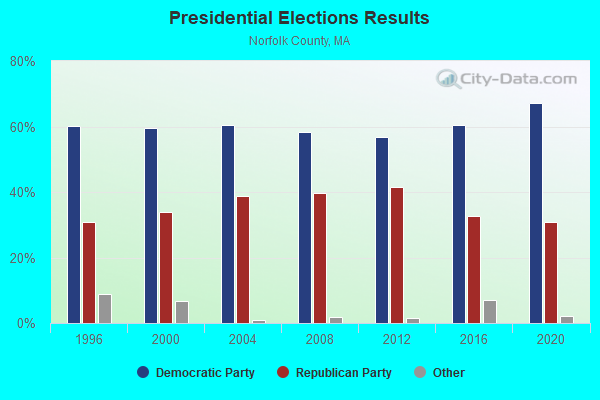
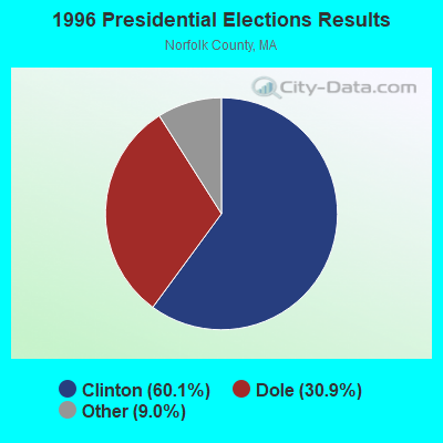
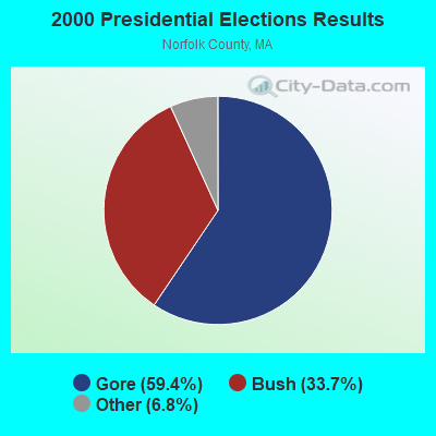
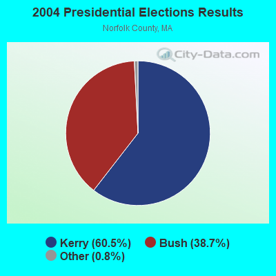
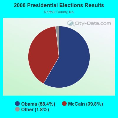
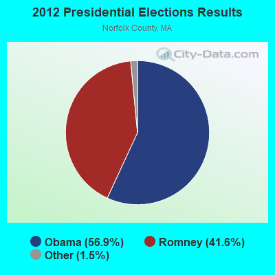

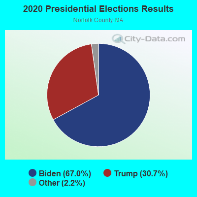
Graphs represent county-level data. Detailed 2008 Election Results
Religion statistics for Canton, MA (based on Norfolk County data)
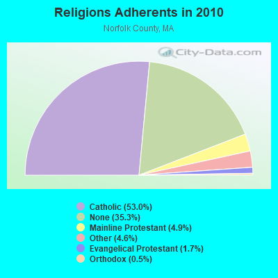
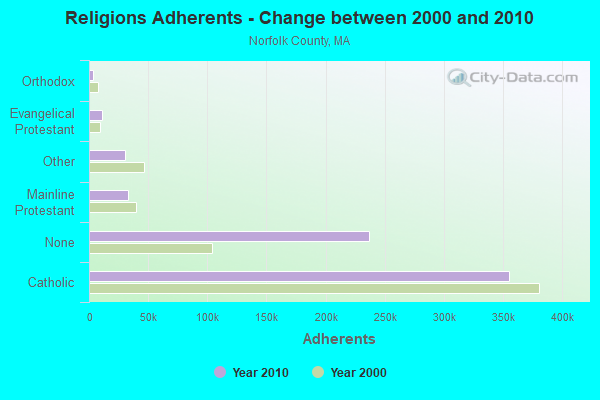
| Religion | Adherents | Congregations |
|---|---|---|
| Catholic | 355,321 | 52 |
| Mainline Protestant | 33,086 | 115 |
| Other | 30,593 | 75 |
| Evangelical Protestant | 11,323 | 89 |
| Orthodox | 3,539 | 9 |
| None | 236,988 | - |
Food Environment Statistics:
| Norfolk County: | 1.65 / 10,000 pop. |
| Massachusetts: | 1.98 / 10,000 pop. |
| Norfolk County: | 0.09 / 10,000 pop. |
| State: | 0.05 / 10,000 pop. |
| Norfolk County: | 2.04 / 10,000 pop. |
| State: | 2.22 / 10,000 pop. |
| Norfolk County: | 1.57 / 10,000 pop. |
| State: | 1.77 / 10,000 pop. |
| Here: | 8.48 / 10,000 pop. |
| State: | 8.76 / 10,000 pop. |
| This county: | 7.1% |
| Massachusetts: | 8.1% |
| Here: | 19.1% |
| State: | 22.5% |
| Norfolk County: | 12.9% |
| Massachusetts: | 16.5% |
8.01% of this county's 2021 resident taxpayers lived in other counties in 2020 ($110,572 average adjusted gross income)
| Here: | 8.01% |
| Massachusetts average: | 6.35% |
0.01% of residents moved from foreign countries ($78 average AGI)
Norfolk County: 0.01% Massachusetts average: 0.01%
Top counties from which taxpayers relocated into this county between 2020 and 2021:
| from Suffolk County, MA | |
| from Middlesex County, MA | |
| from Plymouth County, MA |
8.55% of this county's 2020 resident taxpayers moved to other counties in 2021 ($128,358 average adjusted gross income)
| Here: | 8.55% |
| Massachusetts average: | 7.18% |
0.01% of residents moved to foreign countries ($348 average AGI)
Norfolk County: 0.01% Massachusetts average: 0.02%
Top counties to which taxpayers relocated from this county between 2020 and 2021:
| to Suffolk County, MA | |
| to Middlesex County, MA | |
| to Plymouth County, MA |
| Businesses in Canton, MA | ||||
| Name | Count | Name | Count | |
|---|---|---|---|---|
| 7-Eleven | 1 | JoS. A. Bank | 1 | |
| Ace Hardware | 1 | Marshalls | 1 | |
| Ann Taylor | 1 | McDonald's | 1 | |
| Bath & Body Works | 1 | New Balance | 1 | |
| CVS | 1 | Nike | 2 | |
| Chico's | 1 | Rite Aid | 1 | |
| Dunkin Donuts | 5 | Shaw's | 1 | |
| FedEx | 8 | Starbucks | 1 | |
| GNC | 1 | UPS | 10 | |
| GameStop | 1 | Vans | 1 | |
| Gap | 1 | Walgreens | 1 | |
Strongest AM radio stations in Canton:
- WEEI (850 AM; 50 kW; BOSTON, MA; Owner: ENTERCOM BOSTON LICENSE, LLC)
- WBZ (1030 AM; 50 kW; BOSTON, MA; Owner: INFINITY BROADCASTING OPERATIONS, INC.)
- WUNR (1600 AM; 20 kW; BROOKLINE, MA; Owner: CHAMPION BROADCASTING SYSTEMS, INC.)
- WWZN (1510 AM; 50 kW; BOSTON, MA; Owner: ROSE CITY RADIO CORPORATION)
- WKOX (1200 AM; 50 kW; FRAMINGHAM, MA; Owner: CAPSTAR TX LIMITED PARTNERSHIP)
- WRKO (680 AM; 50 kW; BOSTON, MA; Owner: ENTERCOM BOSTON LICENSE, LLC)
- WBIX (1060 AM; 40 kW; NATICK, MA; Owner: LANGER BROADCASTING CORPORATION)
- WAMG (890 AM; 25 kW; DEDHAM, MA; Owner: MEGA COMMUNICATIONS OF DEDHAM LICENSEE, LLC)
- WRCA (1330 AM; 25 kW; WALTHAM, MA; Owner: WRCA LICENSE, LLC)
- WALE (990 AM; 50 kW; GREENVILLE, RI; Owner: NORTH AMERICAN BROADCASTING CO., INC.)
- WMKI (1260 AM; 5 kW; BOSTON, MA; Owner: ABC, INC.)
- WBET (1460 AM; 5 kW; BROCKTON, MA; Owner: KJI BROADCASTING, LLC)
- WCRN (830 AM; 50 kW; WORCESTER, MA; Owner: CARTER BROADCASTING CORPORATION)
Strongest FM radio stations in Canton:
- WBOS (92.9 FM; BROOKLINE, MA; Owner: GREATER BOSTON RADIO, INC.)
- WBMX (98.5 FM; BOSTON, MA; Owner: INFINITY RADIO OPERATIONS INC.)
- WJMN (94.5 FM; BOSTON, MA; Owner: AMFM RADIO LICENSES, L.L.C.)
- WCRB (102.5 FM; WALTHAM, MA; Owner: CHARLES RIVER BROADCASTING WCRB LICE)
- WTKK (96.9 FM; BOSTON, MA; Owner: GREATER BOSTON RADIO, INC.)
- WROR-FM (105.7 FM; FRAMINGHAM, MA; Owner: GREATER BOSTON RADIO, INC.)
- WGBH (89.7 FM; BOSTON, MA; Owner: WGBH EDUCATIONAL FOUNDATION)
- WBUR-FM (90.9 FM; BOSTON, MA; Owner: TRUSTEES OF BOSTON UNIVERSITY)
- WXKS-FM (107.9 FM; MEDFORD, MA; Owner: AMFM RADIO LICENSES, L.L.C.)
- WMJX (106.7 FM; BOSTON, MA; Owner: GREATER BOSTON RADIO, INC.)
- WODS (103.3 FM; BOSTON, MA; Owner: INFINITY BROADCASTING OPERATIONS, INC.)
- WBOT (97.7 FM; BROCKTON, MA; Owner: RADIO ONE LICENSES, LLC)
- WBCN (104.1 FM; BOSTON, MA; Owner: HEMISPHERE BROADCASTING CORPORATION)
- WZLX (100.7 FM; BOSTON, MA; Owner: INFINITY BROADCASTING CORPORATION OF BOSTON)
- W267AI (101.3 FM; BOSTON, MA; Owner: MCC BROADCASTING COMPANY, INC.)
- WERS (88.9 FM; BOSTON, MA; Owner: EMERSON COLLEGE)
- WHRB (95.3 FM; CAMBRIDGE, MA; Owner: HARVARD RADIO BROADCASTING CO., INC.)
- WWBB (101.5 FM; PROVIDENCE, RI; Owner: CLEAR CHANNEL BROADCASTING LICENSES, INC.)
- WUMB-FM (91.9 FM; BOSTON, MA; Owner: THE UNIVERSITY OF MASSACHUSETTS)
- WMLN-FM (91.5 FM; MILTON, MA; Owner: CURRY COLLEGE)
TV broadcast stations around Canton:
- WCVB-TV (Channel 5; BOSTON, MA; Owner: WCVB HEARST-ARGYLE TV, INC.)
- WGBH-TV (Channel 2; BOSTON, MA; Owner: WGBH EDUCATIONAL FOUNDATION)
- WSBK-TV (Channel 38; BOSTON, MA; Owner: VIACOM INC.)
- WHDH-TV (Channel 7; BOSTON, MA; Owner: WHDH-TV)
- WLVI-TV (Channel 56; CAMBRIDGE, MA; Owner: WLVI, INC.)
- WMFP (Channel 62; LAWRENCE, MA; Owner: WSAH LICENSE, INC.)
- WFXT (Channel 25; BOSTON, MA; Owner: FOX TELEVISION STATIONS INC.)
- WBZ-TV (Channel 4; BOSTON, MA; Owner: VIACOM INC.)
- WGBX-TV (Channel 44; BOSTON, MA; Owner: WGBH EDUCATIONAL FOUNDATION)
- WWDP (Channel 46; NORWELL, MA; Owner: NORWELL TELEVISION, LLC)
- W40BO (Channel 40; BOSTON, MA; Owner: PAXSON COMMUNICATIONS LPTV, INC.)
- WBPX (Channel 68; BOSTON, MA; Owner: PAXSON BOSTON-68 LICENSE, INC.)
- WTMU-LP (Channel 32; BOSTON, MA; Owner: ZGS BOSTON, INC.)
- WCEA-LP (Channel 58; BOSTON, MA; Owner: CHANNEL 19 TV CORPORATION)
- WUTF (Channel 66; MARLBOROUGH, MA; Owner: TELEFUTURA BOSTON LLC)
- WLNE-TV (Channel 6; NEW BEDFORD, MA; Owner: FREEDOM BROADCASTING OF SOUTHERN NEW ENGLAND, INC.)
- WPRI-TV (Channel 12; PROVIDENCE, RI; Owner: TVL BROADCASTING OF RHODE ISLAND, LLC)
- WNAC-TV (Channel 64; PROVIDENCE, RI; Owner: WNAC, LLC)
- WJAR (Channel 10; PROVIDENCE, RI; Owner: OUTLET BROADCASTING, INC.)
- WUNI (Channel 27; WORCESTER, MA; Owner: ENTRAVISION HOLDINGS, LLC)
- WSBE-TV (Channel 36; PROVIDENCE, RI; Owner: RHODE ISLAND PUBLIC TELECOM. AUTHORITY)
- WLWC (Channel 28; NEW BEDFORD, MA; Owner: C-28 FCC LICENSEE SUBSIDIARY, LLC)
- WPXQ (Channel 69; BLOCK ISLAND, RI; Owner: OCEAN STATE TELEVISION, L.L.C.)
- WFXZ-CA (Channel 24; BOSTON, MA; Owner: BOSTON BROADCASTING CORP.)
- National Bridge Inventory (NBI) Statistics
- 30Number of bridges
- 358ft / 109mTotal length
- $92,614,000Total costs
- 1,194,933Total average daily traffic
- 89,003Total average daily truck traffic
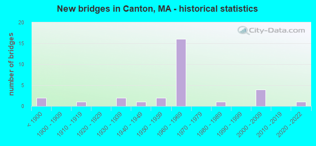
- New bridges - historical statistics
- 2Before 1900
- 11910-1919
- 21930-1939
- 11940-1949
- 21950-1959
- 161960-1969
- 11980-1989
- 42000-2009
- 12020-2022
FCC Registered Commercial Land Mobile Towers: 3 (See the full list of FCC Registered Commercial Land Mobile Towers in Canton, MA)
FCC Registered Private Land Mobile Towers: 1 (See the full list of FCC Registered Private Land Mobile Towers)
FCC Registered Broadcast Land Mobile Towers: 25 (See the full list of FCC Registered Broadcast Land Mobile Towers)
FCC Registered Microwave Towers: 22 (See the full list of FCC Registered Microwave Towers in this town)
FCC Registered Amateur Radio Licenses: 69 (See the full list of FCC Registered Amateur Radio Licenses in Canton)
FAA Registered Aircraft: 8 (See the full list of FAA Registered Aircraft in Canton)
2002 - 2018 National Fire Incident Reporting System (NFIRS) incidents
- Fire incident types reported to NFIRS in Canton, MA
- 37043.7%Structure Fires
- 28533.7%Mobile Property/Vehicle Fires
- 10111.9%Outside Fires
- 9010.6%Other
 According to the data from the years 2002 - 2018 the average number of fire incidents per year is 50. The highest number of reported fire incidents - 84 took place in 2018, and the least - 19 in 2013. The data has an increasing trend.
 When looking into fire subcategories, the most incidents belonged to: Structure Fires (43.7%), and Mobile Property/Vehicle Fires (33.7%).
- 56.1%Utility gas
- 35.7%Fuel oil, kerosene, etc.
- 7.2%Electricity
- 0.5%Wood
- 0.4%Bottled, tank, or LP gas
- 0.1%No fuel used
- 46.6%Utility gas
- 29.2%Electricity
- 20.0%Fuel oil, kerosene, etc.
- 2.6%Bottled, tank, or LP gas
- 1.1%No fuel used
- 0.4%Other fuel
Canton compared to Massachusetts state average:
- Unemployed percentage significantly below state average.
- Hispanic race population percentage significantly below state average.
- Foreign-born population percentage below state average.
- Length of stay since moving in significantly above state average.
- Number of rooms per house significantly below state average.
- House age significantly below state average.
Canton on our top lists:
- #33 on the list of "Top 101 cities with the most people taking railroad to work (population 5,000+)"
- #49 on the list of "Top 101 cities with largest percentage of females in industries: clothing and accessories, including shoe, stores (population 5,000+)"
- #53 on the list of "Top 101 cities with largest percentage of females in industries: radio, tv, and computer stores (population 5,000+)"
- #55 on the list of "Top 101 cities with largest percentage of males in occupations: accountants and auditors (population 5,000+)"
- #58 on the list of "Top 101 cities with the largest racial income disparity between any two races with at least 200 householders"
- #59 on the list of "Top 101 cities with largest percentage of females in occupations: financial managers (population 5,000+)"
- #68 on the list of "Top 101 cities with largest percentage of males in industries: professional and commercial equipment and supplies merchant wholesalers (population 5,000+)"
- #77 on the list of "Top 101 cities with largest percentage of males in occupations: computer specialists (population 5,000+)"
- #79 on the list of "Top 101 cities with largest percentage of females in occupations: other protective service workers including supervisors (population 5,000+)"
- #79 on the list of "Top 101 cities with largest percentage of females in industries: music stores (population 5,000+)"
- #80 on the list of "Top 101 cities with largest percentage of females in occupations: operations specialties managers except financial managers (population 5,000+)"
- #80 on the list of "Top 101 cities with largest percentage of females in industries: retail florists (population 5,000+)"
- #83 on the list of "Top 101 cities with largest percentage of females in industries: electrical and electronic goods merchant wholesalers (population 5,000+)"
- #84 on the list of "Top 101 cities with largest percentage of females in occupations: top executives (population 5,000+)"
- #94 on the list of "Top 101 cities with the largest percentage of people in other hospitals or wards for chronically ill (population 1,000+)"
- #99 on the list of "Top 101 cities with largest percentage of females in industries: leather and allied products (population 5,000+)"
- #41 (02021) on the list of "Top 101 zip codes with the largest percentage of Irish first ancestries (pop 5,000+)"
- #7 on the list of "Top 101 counties with the highest percentage of residents that visited a dentist within the past year"
- #12 on the list of "Top 101 counties with the lowest percentage of residents that keep firearms around their homes"
- #13 on the list of "Top 101 counties with the best general health status score of residents (1-5), 3 years of data"
- #18 on the list of "Top 101 counties with the lowest Nitrogen Dioxide air pollution readings in 2012 (ppm)"
- #25 on the list of "Top 101 counties with the lowest number of infant deaths per 1000 residents 2007-2013 (pop. 50,000+)"

|
|
Total of 615 patent applications in 2008-2024.