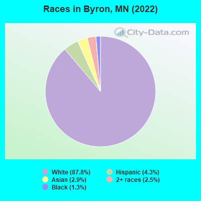
Percentage of residents living in poverty in 2022: 5.3%
(2.6% for White Non-Hispanic residents, 71.1% for Hispanic or Latino residents, 100.0% for other race residents, 0.7% for two or more races residents)
Latest news from Byron, MN collected exclusively by city-data.com from local newspapers, TV, and radio stations
Ancestries: German (25.3%), Norwegian (13.2%), English (7.4%), American (6.2%), Polish (6.0%), Irish (5.3%).
Current Local Time: CST time zone
Elevation: 1262 feet
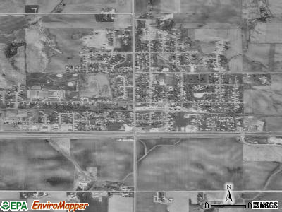
Land area: 1.42 square miles.
Population density: 4,712 people per square mile (average).
226 residents are foreign born (1.1% Europe, 1.1% Asia, 0.9% Latin America).
This city:
3.5%
Minnesota:
8.5%
Median real estate property taxes paid for housing units with mortgages in 2022: $4,396 (1.3%) Median real estate property taxes paid for housing units with no mortgage in 2022: $3,337 (1.2%)
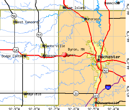
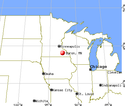
Nearest city with pop. 50,000+: Rochester, MN (8.7 miles , pop. 85,806).
Nearest city with pop. 200,000+: St. Paul, MN (67.8 miles , pop. 287,151).
Nearest city with pop. 1,000,000+: Chicago, IL (293.6 miles , pop. 2,896,016).
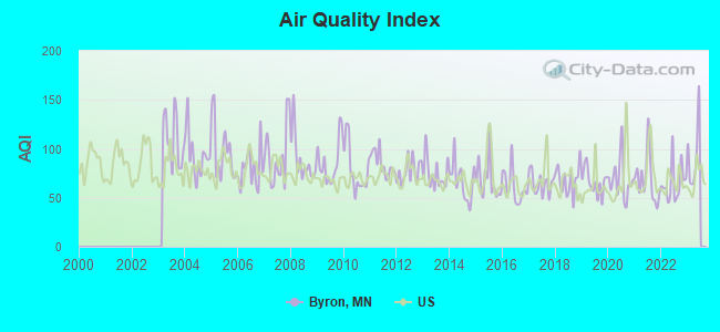
Air Quality Index (AQI) level in 2022 was 64.9. This is about average.
City:
64.9
U.S.:
72.6
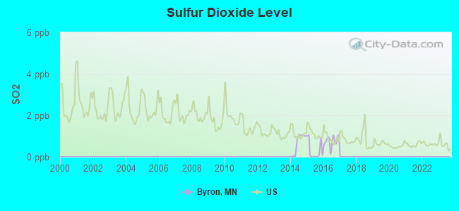
Sulfur Dioxide (SO2) [ppb] level in 2016 was 0.752. This is significantly better than average.Closest monitor was 9.0 miles away from the city center.
City:
0.752
U.S.:
1.515
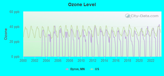
Ozone [ppb] level in 2022 was 31.4. This is about average.Closest monitor was 6.9 miles away from the city center.
City:
31.4
U.S.:
33.3
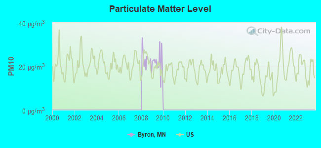
Particulate Matter (PM10) [µg/m3] level in 2009 was 21.7. This is about average.Closest monitor was 9.4 miles away from the city center.
City:
21.7
U.S.:
19.2
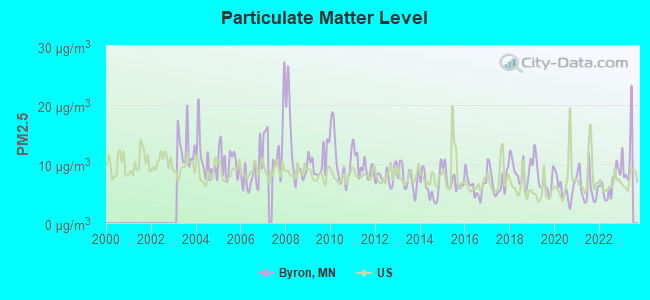
Particulate Matter (PM2.5) [µg/m3] level in 2022 was 6.64. This is better than average.Closest monitor was 10.1 miles away from the city center.
City:
6.64
U.S.:
8.11
Tornado activity:
Byron-area historical tornado activity is slightly above Minnesota state average. It is 42% greater than the overall U.S. average.
On 9/16/1962, a category F4 (max. wind speeds 207-260 mph) tornado 10.7 miles away from the Byron city center injured 34 peopleand causedbetween $50,000 and $500,000 in damages.
On 5/15/1968, a category F5 (max. wind speeds 261-318 mph) tornado 42.0 miles away from the city center killed 13 peopleand injured 462 peopleand causedbetween $5,000,000 and $50,000,000 in damages.
Earthquake activity:
Byron-area historical earthquake activity is significantly above Minnesota state average. It is 70% greater than the overall U.S. average.
On 7/9/1975 at 14:54:15, a magnitude 4.6 (4.6 MB, Class: Light, Intensity: IV - V) earthquake occurred 201.2 miles away from the city center On 6/5/1993 at 01:24:53, a magnitude 4.1 (4.1 LG, Depth: 6.2 mi) earthquake occurred 211.7 miles away from the city center On 6/28/2004 at 06:10:52, a magnitude 4.2 (4.2 MW, Depth: 6.2 mi) earthquake occurred 260.5 miles away from the city center On 4/18/2008 at 09:36:59, a magnitude 5.4 (5.1 MB, 4.8 MS, 5.4 MW, 5.2 MW, Class: Moderate, Intensity: VI - VII) earthquake occurred 458.4 miles away from Byron center On 3/4/1983 at 06:32:18, a magnitude 4.6 (4.4 MB, 4.6 LG, 4.4 ML) earthquake occurred 335.9 miles away from the city center On 6/10/1987 at 23:48:54, a magnitude 5.1 (4.9 MB, 4.4 MS, 4.6 MS, 5.1 LG) earthquake occurred 436.8 miles away from Byron center Magnitude types: regional Lg-wave magnitude (LG), body-wave magnitude (MB), local magnitude (ML), surface-wave magnitude (MS), moment magnitude (MW)
Natural disasters:
The number of natural disasters in Olmsted County (14) is near the US average (15). Major Disasters (Presidential) Declared: 10 Emergencies Declared: 2
Causes of natural disasters: Floods: 9, Storms: 7, Tornadoes: 3, Winds: 2, Drought: 1, Hurricane: 1, Ice Storm: 1, Winter Storm: 1, Other: 1 (Note: some incidents may be assigned to more than one category).
Hospitals and medical centers near Byron:
KASSON MSOCS (Hospital, about 5 miles away; KASSON, MN)
SEASONS HOSPICE (Hospital, about 7 miles away; ROCHESTER, MN)
AMEDISYS HOME HEALTH OF MN (Home Health Center, about 7 miles away; ROCHESTER, MN)
INTERNATIONAL QUALITY HOMECARE (Home Health Center, about 7 miles away; ROCHESTER, MN)
CNS HOME HEALTH CARE (Home Health Center, about 7 miles away; ROCHESTER, MN)
MAPLE MANOR HEALTHCARE AND REHAB (Nursing Home, about 8 miles away; ROCHESTER, MN)
GOLDEN LIVINGCENTER - ROCHESTER WEST (Nursing Home, about 8 miles away; ROCHESTER, MN)
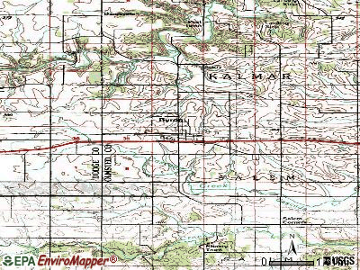
Churches in Byron include: Christ the King Catholic Church (A), Christ Lutheran Church (B), Community Celebration Church (C), Mount Moriah Lutheran Church (D), United Methodist Church (E). Display/hide their locations on the map
Olmsted County has a predicted average indoor radon screening level greater than 4 pCi/L (pico curies per liter) - Highest Potential
Drinking water stations with addresses in Byron and their reported violations in the past:
COUNTRY HOME TRAILER PARK (Population served: 56, Groundwater):
Past monitoring violations:
Initial Tap Sampling for Pb and Cu - In JUL-01-1993, Contaminant: Lead and Copper Rule. Follow-up actions: St Violation/Reminder Notice (2 times from NOV-01-1993 to DEC-01-1993), St Formal NOV issued (FEB-11-1994), St Other (MAR-28-1994), St Compliance achieved (MAR-30-1994), Fed PAO issued (MAY-23-1994), Fed FAO issued (OCT-31-1994)
Drinking water stations with addresses in Byron that have no violations reported:
BYRON (Population served: 4,995,Primary Water Source Type: Groundwater)
Average household size:
This city:
2.7 people
Minnesota:
2.5 people
Percentage of family households:
This city:
76.1%
Whole state:
64.6%
Percentage of households with unmarried partners:
This city:
5.7%
Whole state:
6.9%
Likely homosexual households (counted as self-reported same-sex unmarried-partner households)
Lesbian couples: 0.1% of all households
Gay men: 0.1% of all households
5 people in group homes intended for adults in 2010
Banks with branches in Byron (2011 data):
First Security Bank: at 316 Byron Avenue, North, branch established on 1904/12/27. Info updated 2006/11/03: Bank assets: $50.9 mil, Deposits: $42.9 mil, local headquarters, positive income, Commercial Lending Specialization, 1 total offices, Holding Company: Olmsted Bancorporation, Inc.
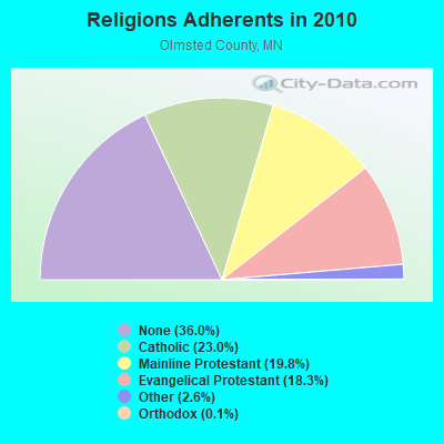
Religion statistics for Byron, MN (based on Olmsted County data)
Religion
Adherents
Congregations
Catholic
33,236
10
Mainline Protestant
28,625
38
Evangelical Protestant
26,365
74
Other
3,781
15
Orthodox
200
1
Black Protestant
62
1
None
51,979
-
Source: Clifford Grammich, Kirk Hadaway, Richard Houseal, Dale E.Jones, Alexei Krindatch, Richie Stanley and Richard H.Taylor. 2012. 2010 U.S.Religion Census: Religious Congregations & Membership Study. Association of Statisticians of American Religious Bodies. Jones, Dale E., et al. 2002. Congregations and Membership in the United States 2000. Nashville, TN: Glenmary Research Center. Graphs represent county-level data
Aircraft: SUTTON RAY RENEGADE SPIRIT (Category: Land, Seats: 2, Weight: Up to 12,499 Pounds), Engine: AMA/EXPR UNKNOWN ENG (Reciprocating) N-Number: 2413Q, N2413Q, N-2413Q, Serial Number: REN 617, Year manufactured: 2001, Airworthiness Date: 04/17/2002, Certificate Issue Date: 10/20/2001 Registrant (Individual): Ray E Sutton, 7229 Genoa Rd Nw, Byron, MN 55920
Aircraft: CESSNA 172M (Category: Land, Seats: 4, Weight: Up to 12,499 Pounds, Speed: 108 mph), Engine: LYCOMING 0-320 SERIES (180 HP) (4 Cycle) N-Number: 301ND, N301ND, N-301ND, Serial Number: 17261763, Airworthiness Date: 06/09/1993, Certificate Issue Date: 07/23/2020 Registrant (Individual): Mark D Baron, 1104 4th Ave Ne, Byron, MN 55920 Deregistered:Cancel Date: 05/04/2019
Aircraft: MOONEY M20J (Category: Land, Seats: 4, Weight: Up to 12,499 Pounds, Speed: 126 mph), Engine: LYCOMING I0360 SER A&C (200 HP) (Reciprocating) N-Number: 5257T, N5257T, N-5257T, Serial Number: 24-1661, Airworthiness Date: 07/28/1988, Certificate Issue Date: 09/08/2020 Registrant (Individual): Mark D Baron, 1104 4th Ave Ne, Byron, MN 55920 Deregistered:Cancel Date: 03/27/2018
Aircraft: PURDUE RICHARD H CHALLENGER II (Category: Land, Seats: 2, Weight: Up to 12,499 Pounds), Engine: BOMBARDIER ROTAX (ALL) (Reciprocating) N-Number: 665DC, N665DC, N-665DC, Serial Number: CH2-1204-2571, Year manufactured: 2006, Airworthiness Date: 05/03/2006, Certificate Issue Date: 10/03/2005 Registrant (Individual): Richard H Purdue, 7101 80th Ave Nw, Byron, MN 55920
Aircraft: MOONEY M20C (Category: Land, Seats: 4, Weight: Up to 12,499 Pounds, Speed: 127 mph), Engine: LYCOMING O&VO-360 SER (180 HP) (Reciprocating) N-Number: 6805N, N6805N, N-6805N, Serial Number: 680105, Airworthiness Date: 06/28/1968, Certificate Issue Date: 09/01/2020 Registrant (Individual): Mark Baron, 1104 4th Ave Ne, Byron, MN 55920 Deregistered:Cancel Date: 12/17/2018
Aircraft: WHARTON JAMES R STOL CH-701 (Category: Land, Seats: 2, Weight: Up to 12,499 Pounds), Engine: Reciprocating N-Number: 805U, N805U, N-805U, Serial Number: 7-4633, Certificate Issue Date: 12/24/2008 Registrant (Individual): James R Wharton, 1845 23rd St Nw, Byron, MN 55920
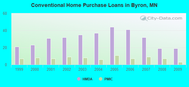
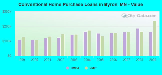
Home Mortgage Disclosure Act Aggregated Statistics For Year 2009 (Based on 1 partial tract)
A) FHA, FSA/RHS & VA Home Purchase Loans
B) Conventional Home Purchase Loans
C) Refinancings
D) Home Improvement Loans
E) Loans on Dwellings For 5+ Families
F) Non-occupant Loans on < 5 Family Dwellings (A B C & D)
Number
Average Value
Number
Average Value
Number
Average Value
Number
Average Value
Number
Average Value
Number
Average Value
LOANS ORIGINATED
13
$158,137
19
$162,973
78
$156,091
4
$42,362
1
$1,931,650
1
$284,390
APPLICATIONS APPROVED, NOT ACCEPTED
0
$0
1
$202,620
6
$159,438
0
$0
0
$0
0
$0
APPLICATIONS DENIED
1
$300,160
1
$186,200
15
$153,954
1
$18,720
0
$0
0
$0
APPLICATIONS WITHDRAWN
0
$0
1
$239,400
11
$208,922
1
$14,450
0
$0
0
$0
FILES CLOSED FOR INCOMPLETENESS
0
$0
0
$0
3
$187,407
0
$0
0
$0
0
$0
Aggregated Statistics For Year 2008 (Based on 1 partial tract)
A) FHA, FSA/RHS & VA Home Purchase Loans
B) Conventional Home Purchase Loans
C) Refinancings
D) Home Improvement Loans
E) Loans on Dwellings For 5+ Families
F) Non-occupant Loans on < 5 Family Dwellings (A B C & D)
Number
Average Value
Number
Average Value
Number
Average Value
Number
Average Value
Number
Average Value
Number
Average Value
LOANS ORIGINATED
9
$147,013
19
$185,857
33
$140,376
5
$39,736
1
$1,055,810
1
$123,480
APPLICATIONS APPROVED, NOT ACCEPTED
1
$180,290
2
$129,390
6
$110,562
1
$11,820
0
$0
0
$0
APPLICATIONS DENIED
0
$0
3
$140,117
18
$143,018
4
$24,465
0
$0
2
$131,855
APPLICATIONS WITHDRAWN
1
$155,990
5
$191,852
11
$146,168
1
$16,420
0
$0
1
$118,880
FILES CLOSED FOR INCOMPLETENESS
0
$0
0
$0
2
$122,655
0
$0
0
$0
0
$0
Aggregated Statistics For Year 2007 (Based on 1 partial tract)
A) FHA, FSA/RHS & VA Home Purchase Loans
B) Conventional Home Purchase Loans
C) Refinancings
D) Home Improvement Loans
F) Non-occupant Loans on < 5 Family Dwellings (A B C & D)
G) Loans On Manufactured Home Dwelling (A B C & D)
Number
Average Value
Number
Average Value
Number
Average Value
Number
Average Value
Number
Average Value
Number
Average Value
LOANS ORIGINATED
3
$180,290
32
$161,450
36
$118,644
8
$30,295
3
$123,150
0
$0
APPLICATIONS APPROVED, NOT ACCEPTED
0
$0
3
$176,133
4
$128,322
1
$30,540
0
$0
0
$0
APPLICATIONS DENIED
0
$0
2
$144,005
24
$154,197
3
$70,823
0
$0
1
$31,200
APPLICATIONS WITHDRAWN
0
$0
2
$177,010
10
$154,775
2
$42,365
0
$0
0
$0
FILES CLOSED FOR INCOMPLETENESS
0
$0
1
$62,720
1
$165,840
1
$13,140
0
$0
0
$0
Aggregated Statistics For Year 2006 (Based on 1 partial tract)
A) FHA, FSA/RHS & VA Home Purchase Loans
B) Conventional Home Purchase Loans
C) Refinancings
D) Home Improvement Loans
F) Non-occupant Loans on < 5 Family Dwellings (A B C & D)
Number
Average Value
Number
Average Value
Number
Average Value
Number
Average Value
Number
Average Value
LOANS ORIGINATED
5
$146,138
41
$154,556
38
$112,710
10
$45,188
5
$139,110
APPLICATIONS APPROVED, NOT ACCEPTED
0
$0
3
$100,163
7
$102,930
1
$65,020
1
$91,300
APPLICATIONS DENIED
0
$0
2
$140,720
23
$134,173
3
$21,237
0
$0
APPLICATIONS WITHDRAWN
0
$0
4
$149,585
16
$140,678
1
$31,530
0
$0
FILES CLOSED FOR INCOMPLETENESS
0
$0
0
$0
5
$156,188
0
$0
0
$0
Aggregated Statistics For Year 2005 (Based on 1 partial tract)
A) FHA, FSA/RHS & VA Home Purchase Loans
B) Conventional Home Purchase Loans
C) Refinancings
D) Home Improvement Loans
F) Non-occupant Loans on < 5 Family Dwellings (A B C & D)
G) Loans On Manufactured Home Dwelling (A B C & D)
Number
Average Value
Number
Average Value
Number
Average Value
Number
Average Value
Number
Average Value
Number
Average Value
LOANS ORIGINATED
4
$163,872
44
$152,049
47
$109,462
11
$35,795
2
$141,210
0
$0
APPLICATIONS APPROVED, NOT ACCEPTED
0
$0
2
$130,540
6
$97,535
0
$0
0
$0
0
$0
APPLICATIONS DENIED
0
$0
2
$137,435
33
$143,003
3
$48,167
0
$0
1
$27,910
APPLICATIONS WITHDRAWN
0
$0
3
$129,170
16
$127,666
3
$100,710
0
$0
0
$0
FILES CLOSED FOR INCOMPLETENESS
0
$0
2
$169,125
3
$150,187
1
$11,490
1
$80,130
0
$0
Aggregated Statistics For Year 2004 (Based on 1 partial tract)
A) FHA, FSA/RHS & VA Home Purchase Loans
B) Conventional Home Purchase Loans
C) Refinancings
D) Home Improvement Loans
F) Non-occupant Loans on < 5 Family Dwellings (A B C & D)
Number
Average Value
Number
Average Value
Number
Average Value
Number
Average Value
Number
Average Value
LOANS ORIGINATED
6
$131,032
37
$164,138
47
$112,879
8
$20,649
1
$122,160
APPLICATIONS APPROVED, NOT ACCEPTED
0
$0
2
$235,300
8
$115,474
0
$0
0
$0
APPLICATIONS DENIED
0
$0
3
$150,627
22
$114,835
2
$28,900
0
$0
APPLICATIONS WITHDRAWN
0
$0
4
$102,215
12
$118,552
0
$0
0
$0
FILES CLOSED FOR INCOMPLETENESS
0
$0
0
$0
7
$145,200
0
$0
0
$0
Aggregated Statistics For Year 2003 (Based on 1 partial tract)
A) FHA, FSA/RHS & VA Home Purchase Loans
B) Conventional Home Purchase Loans
C) Refinancings
D) Home Improvement Loans
F) Non-occupant Loans on < 5 Family Dwellings (A B C & D)
Number
Average Value
Number
Average Value
Number
Average Value
Number
Average Value
Number
Average Value
LOANS ORIGINATED
8
$139,980
35
$142,732
106
$121,988
6
$45,538
4
$129,965
APPLICATIONS APPROVED, NOT ACCEPTED
0
$0
2
$108,370
6
$104,760
0
$0
0
$0
APPLICATIONS DENIED
1
$107,390
2
$111,655
27
$117,202
2
$20,030
0
$0
APPLICATIONS WITHDRAWN
0
$0
1
$86,700
15
$108,744
0
$0
0
$0
FILES CLOSED FOR INCOMPLETENESS
0
$0
0
$0
3
$111,767
0
$0
0
$0
Aggregated Statistics For Year 2002 (Based on 1 partial tract)
A) FHA, FSA/RHS & VA Home Purchase Loans
B) Conventional Home Purchase Loans
C) Refinancings
D) Home Improvement Loans
F) Non-occupant Loans on < 5 Family Dwellings (A B C & D)
Number
Average Value
Number
Average Value
Number
Average Value
Number
Average Value
Number
Average Value
LOANS ORIGINATED
9
$128,952
32
$123,786
76
$117,934
3
$27,147
2
$116,745
APPLICATIONS APPROVED, NOT ACCEPTED
0
$0
0
$0
6
$115,378
0
$0
0
$0
APPLICATIONS DENIED
0
$0
2
$125,775
15
$92,368
3
$17,187
0
$0
APPLICATIONS WITHDRAWN
0
$0
2
$94,085
11
$122,762
0
$0
0
$0
FILES CLOSED FOR INCOMPLETENESS
0
$0
1
$89,000
5
$132,674
0
$0
0
$0
Aggregated Statistics For Year 2001 (Based on 1 partial tract)
A) FHA, FSA/RHS & VA Home Purchase Loans
B) Conventional Home Purchase Loans
C) Refinancings
D) Home Improvement Loans
Number
Average Value
Number
Average Value
Number
Average Value
Number
Average Value
LOANS ORIGINATED
13
$118,855
31
$121,137
74
$104,586
11
$20,421
APPLICATIONS APPROVED, NOT ACCEPTED
0
$0
0
$0
5
$106,730
1
$9,850
APPLICATIONS DENIED
0
$0
2
$57,965
14
$86,885
1
$24,960
APPLICATIONS WITHDRAWN
0
$0
2
$142,525
10
$103,676
0
$0
FILES CLOSED FOR INCOMPLETENESS
0
$0
0
$0
3
$102,900
0
$0
Aggregated Statistics For Year 2000 (Based on 1 partial tract)
A) FHA, FSA/RHS & VA Home Purchase Loans
B) Conventional Home Purchase Loans
C) Refinancings
D) Home Improvement Loans
F) Non-occupant Loans on < 5 Family Dwellings (A B C & D)
Number
Average Value
Number
Average Value
Number
Average Value
Number
Average Value
Number
Average Value
LOANS ORIGINATED
10
$115,071
23
$108,743
21
$66,368
5
$46,502
2
$57,470
APPLICATIONS APPROVED, NOT ACCEPTED
1
$65,020
1
$69,950
3
$74,000
1
$14,780
0
$0
APPLICATIONS DENIED
0
$0
3
$59,550
11
$60,037
2
$35,305
0
$0
APPLICATIONS WITHDRAWN
0
$0
1
$96,220
3
$39,847
0
$0
1
$33,830
FILES CLOSED FOR INCOMPLETENESS
0
$0
0
$0
3
$89,433
0
$0
0
$0
Aggregated Statistics For Year 1999 (Based on 1 partial tract)
Detailed PMIC statistics for the following Tracts:0018.00
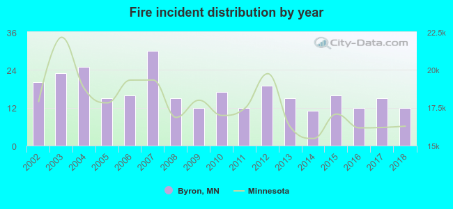
2002 - 2018 National Fire Incident Reporting System (NFIRS) incidents
Based on the data from the years 2002 - 2018 the average number of fires per year is 17. The highest number of reported fires - 30 took place in 2007, and the least - 11 in 2014. The data has a dropping trend.
When looking into fire subcategories, the most incidents belonged to: Outside Fires (36.1%), and Structure Fires (30.5%).
Fire incident types reported to NFIRS in Byron, MN
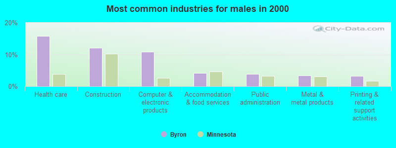
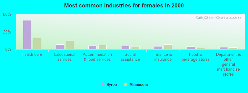
#1 on the list of "Top 101 cities with largest percentage of females in industries: health care and social assistance (population 5,000+)"
#9 on the list of "Top 101 cities with largest percentage of males in industries: health care and social assistance (population 5,000+)"
#15 on the list of "Top 101 cities with the highest percentage of English-only speaking households, population 5,000+"
#34 on the list of "Top 101 cities with largest percentage of females in occupations: health diagnosing and treating practitioners and other technical occupations (population 5,000+)"
#75 on the list of "Top 101 cities with the smallest percentage of likely homosexual households (counted as self-reported same-sex unmarried-partner households) (population 5,000+)"
#31 (55920) on the list of "Top 101 zip codes with the largest percentage of Norwegian first ancestries (pop 5,000+)"
#64 on the list of "Top 101 counties with the largest number of children under 18 without health insurance coverage in 2000 (pop. 50,000+)"
#75 on the list of "Top 101 counties with the largest number of people without health insurance coverage in 2000 (pop. 50,000+)"
#81 on the list of "Top 101 counties with the highest number of births per 1000 residents 2007-2013"
#101 on the list of "Top 101 counties with the largest increase in the number of births per 1000 residents 2000-2006 to 2007-2013 (pop 50,000+)"


 Recent articles from our blog. Our writers, many of them Ph.D. graduates or candidates, create easy-to-read articles on a wide variety of topics.

 (8.7 miles
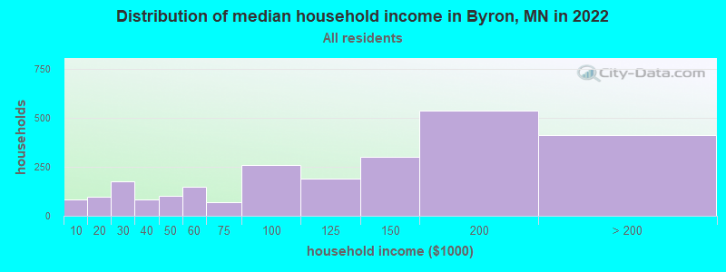


 Based on the data from the years 2002 - 2018 the average number of fires per year is 17. The highest number of reported fires - 30 took place in 2007, and the least - 11 in 2014. The data has a dropping trend.
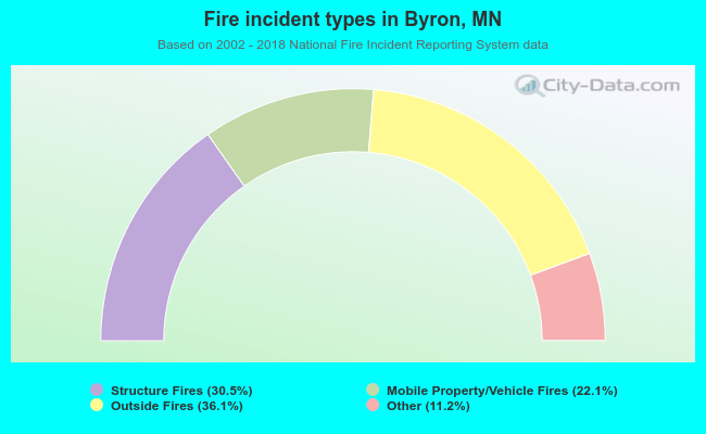 When looking into fire subcategories, the most incidents belonged to: Outside Fires (36.1%), and Structure Fires (30.5%).