Bush, Kentucky
Submit your own pictures of this place and show them to the world
- OSM Map
- General Map
- Google Map
- MSN Map

| Males: 2,216 | |
| Females: 2,213 |
| Median resident age: | 35.9 years |
| Kentucky median age: | 35.9 years |
Zip code: 40741
| Bush: | $63,879 |
| KY: | $59,341 |
Estimated per capita income in 2022: $34,053 (it was $17,733 in 2000)
Bush CCD income, earnings, and wages data
Estimated median house or condo value in 2022: $199,246 (it was $81,500 in 2000)
| Bush: | $199,246 |
| KY: | $196,300 |
Detailed information about poverty and poor residents in Bush, KY


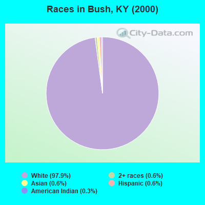
- 4,00697.9%White alone
- 230.6%Asian alone
- 250.6%Two or more races
- 230.6%Hispanic
- 120.3%American Indian alone
- 30.07%Black alone
Races in Bush detailed stats: ancestries, foreign born residents, place of birth
 Recent articles from our blog. Our writers, many of them Ph.D. graduates or candidates, create easy-to-read articles on a wide variety of topics.
Current Local Time: EST time zone
Elevation: 1214 feet
Land area: 36.7 square miles.
Population density: 121 people per square mile (very low).

| Bush CCD: | 0.6% ($506) |
| Kentucky: | 0.8% ($610) |
Nearest city with pop. 50,000+: Fayette, KY  (69.8 miles , pop. 260,512).
Nearest city with pop. 1,000,000+: Chicago, IL (382.3 miles , pop. 2,896,016).
Nearest cities:
), ), ), ), Latitude: 37.11 N, Longitude: 83.98 W
Area code commonly used in this area: 606

| Here: | 4.1% |
| Kentucky: | 3.8% |
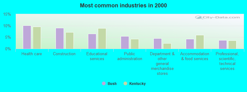
- Health care (10.1%)
- Construction (9.0%)
- Educational services (6.6%)
- Public administration (5.5%)
- Department & other general merchandise stores (4.5%)
- Accommodation & food services (4.3%)
- Professional, scientific, technical services (3.7%)
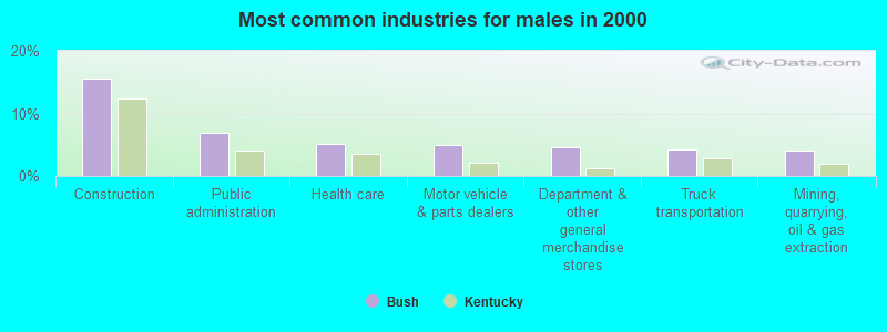
- Construction (15.6%)
- Public administration (6.9%)
- Health care (5.1%)
- Motor vehicle & parts dealers (5.0%)
- Department & other general merchandise stores (4.6%)
- Truck transportation (4.2%)
- Mining, quarrying, oil & gas extraction (4.0%)
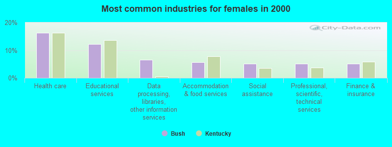
- Health care (16.3%)
- Educational services (12.2%)
- Data processing, libraries, other information services (6.5%)
- Accommodation & food services (5.6%)
- Social assistance (5.1%)
- Professional, scientific, technical services (5.1%)
- Finance & insurance (5.1%)
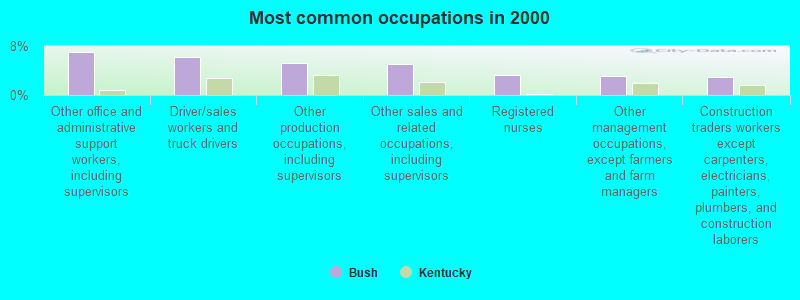
- Other office and administrative support workers, including supervisors (7.0%)
- Driver/sales workers and truck drivers (6.2%)
- Other production occupations, including supervisors (5.2%)
- Other sales and related occupations, including supervisors (5.1%)
- Registered nurses (3.2%)
- Other management occupations, except farmers and farm managers (3.1%)
- Construction traders workers except carpenters, electricians, painters, plumbers, and construction laborers (3.0%)
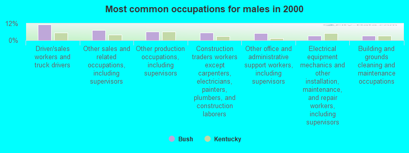
- Driver/sales workers and truck drivers (11.1%)
- Other sales and related occupations, including supervisors (7.4%)
- Other production occupations, including supervisors (6.1%)
- Construction traders workers except carpenters, electricians, painters, plumbers, and construction laborers (5.4%)
- Other office and administrative support workers, including supervisors (5.2%)
- Electrical equipment mechanics and other installation, maintenance, and repair workers, including supervisors (3.2%)
- Building and grounds cleaning and maintenance occupations (3.1%)
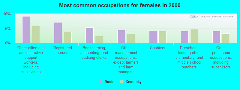
- Other office and administrative support workers, including supervisors (9.2%)
- Registered nurses (7.1%)
- Bookkeeping, accounting, and auditing clerks (5.4%)
- Other management occupations, except farmers and farm managers (4.5%)
- Cashiers (4.2%)
- Preschool, kindergarten, elementary, and middle school teachers (4.1%)
- Other production occupations, including supervisors (4.1%)
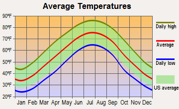
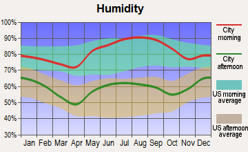
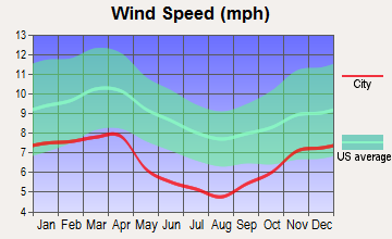
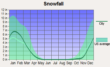
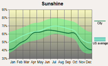
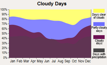
Average climate in Bush, Kentucky
Based on data reported by over 4,000 weather stations

Tornado activity:
Bush-area historical tornado activity is below Kentucky state average. It is 21% smaller than the overall U.S. average.
On 6/29/1973, a category F3 (max. wind speeds 158-206 mph) tornado 5.8 miles away from the Bush place center injured 2 people and caused between $50,000 and $500,000 in damages.
On 4/3/1974, a category F3 tornado 17.0 miles away from the place center killed 7 people and injured 40 people and caused between $500,000 and $5,000,000 in damages.
Earthquake activity:
Bush-area historical earthquake activity is significantly above Kentucky state average. It is 69% greater than the overall U.S. average.On 7/27/1980 at 18:52:21, a magnitude 5.2 (5.1 MB, 4.7 MS, 5.0 UK, 5.2 UK, Class: Moderate, Intensity: VI - VII) earthquake occurred 76.0 miles away from the city center
On 8/9/2020 at 12:07:37, a magnitude 5.1 (5.1 MW, Depth: 4.7 mi) earthquake occurred 165.7 miles away from the city center
On 4/18/2008 at 09:36:59, a magnitude 5.4 (5.1 MB, 4.8 MS, 5.4 MW, 5.2 MW) earthquake occurred 233.0 miles away from Bush center
On 11/30/1973 at 07:48:41, a magnitude 4.7 (4.7 MB, 4.6 ML, Class: Light, Intensity: IV - V) earthquake occurred 90.5 miles away from Bush center
On 9/7/1988 at 02:28:09, a magnitude 4.6 (4.5 MB, 4.6 LG) earthquake occurred 71.9 miles away from Bush center
On 8/23/2011 at 17:51:04, a magnitude 5.8 (5.8 MW, Depth: 3.7 mi) earthquake occurred 336.1 miles away from Bush center
Magnitude types: regional Lg-wave magnitude (LG), body-wave magnitude (MB), local magnitude (ML), surface-wave magnitude (MS), moment magnitude (MW)
Natural disasters:
The number of natural disasters in Laurel County (17) is near the US average (15).Major Disasters (Presidential) Declared: 11
Emergencies Declared: 2
Causes of natural disasters: Floods: 7, Storms: 7, Tornadoes: 6, Winds: 3, Fires: 2, Mudslides: 2, Snows: 2, Winter Storms: 2, Blizzard: 1, Freeze: 1, Hurricane: 1, Landslide: 1, Snowfall: 1, Other: 1 (Note: some incidents may be assigned to more than one category).
Hospitals and medical centers near Bush:
- SETON HOME HEALTH SERVICES (Home Health Center, about 2 miles away; LONDON, KY)
- LONDON DIALYSIS CLINIC (Dialysis Facility, about 8 miles away; LONDON, KY)
- CHRISTIAN HEALTH CENTER (Nursing Home, about 12 miles away; CORBIN, KY)
- PROFESSIONAL HOME HEALTH CARE, INC (Home Health Center, about 12 miles away; LONDON, KY)
- MEMORIAL HOSPITAL HOME HEALTH CARE (Home Health Center, about 13 miles away; MANCHESTER, KY)
- CUMBERLAND VAL DIST HLTH DEPT (Hospital, about 13 miles away; MANCHESTER, KY)
Colleges/universities with over 2000 students nearest to Bush:
- University of the Cumberlands (about 28 miles; Williamsburg, KY; Full-time enrollment: 3,585)
- Somerset Community College (about 36 miles; Somerset, KY; FT enrollment: 4,698)
- Lincoln Memorial University (about 41 miles; Harrogate, TN; FT enrollment: 3,706)
- Hazard Community and Technical College (about 46 miles; Hazard, KY; FT enrollment: 2,087)
- Eastern Kentucky University (about 48 miles; Richmond, KY; FT enrollment: 13,525)
- Southeast Kentucky Community and Technical College (about 56 miles; Cumberland, KY; FT enrollment: 2,196)
- Bluegrass Community and Technical College (about 70 miles; Lexington, KY; FT enrollment: 8,560)
Public elementary/middle school in Bush:
- STAR ELEMENTARY SCHOOL (Students: 128, Location: 8249 E US HWY 60, Grades: PK-5)
Points of interest:
Notable locations in Bush: Laurel County Fairgrounds (A), Bush Fire Department Station 1 (B), Bush Fire Department Station 2 (C). Display/hide their locations on the map
Churches in Bush include: Weaver Church (A), Bush Church (B), Slate Hill Church (C), Shady Grove Baptist Church (D), Rough Creek Church (E), Providence Church (F), Pleasant Valley Church (G), Pine Hill Baptist Church (H), Mount Zion Church (I). Display/hide their locations on the map
Cemeteries: Phelps Cemetery (1), Hoskins Cemetery (2), Harris Cemetery (3), Gregory Cemetery (4), Joe Jones Cemetery (5), Bruner Cemetery (6), Williams Cemetery (7). Display/hide their locations on the map
Streams, rivers, and creeks: Camp Branch (A), Hooppole Creek (B), John Creek (C), Little Sandy Creek (D), Sallys Branch (E), Blackwater Creek (F). Display/hide their locations on the map
Park in Bush: Levi Jackson Wilderness Road State Park (1). Display/hide its location on the map
| This place: | 2.6 people |
| Kentucky: | 2.5 people |
| This place: | 78.0% |
| Whole state: | 66.9% |
| This place: | 4.3% |
| Whole state: | 6.4% |
Likely homosexual households (counted as self-reported same-sex unmarried-partner households)
- Lesbian couples: 0.4% of all households
- Gay men: 0.1% of all households
| This place: | 12.4% |
| Whole state: | 15.8% |
| This place: | 3.8% |
| Whole state: | 6.6% |
For population 15 years and over in Bush:
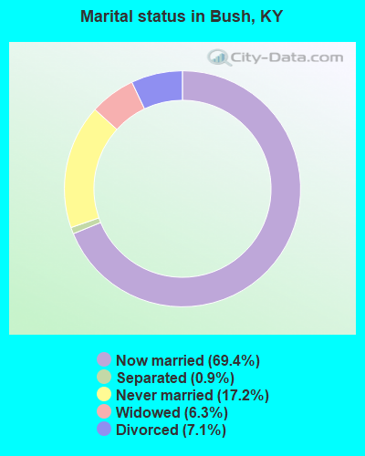
- Never married: 17.2%
- Now married: 69.4%
- Separated: 0.9%
- Widowed: 6.3%
- Divorced: 7.1%
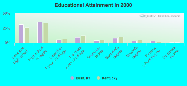
For population 25 years and over in Bush:
- High school or higher: 68.7%
- Bachelor's degree or higher: 14.6%
- Graduate or professional degree: 6.7%
- Unemployed: 3.7%
- Mean travel time to work (commute): 23.3 minutes
| Here: | 14.9 |
| Kentucky average: | 13.8 |
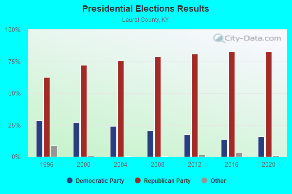
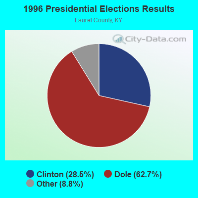
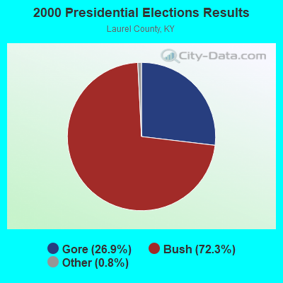
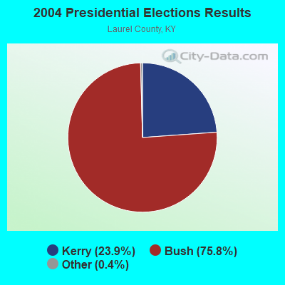
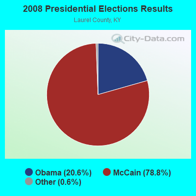
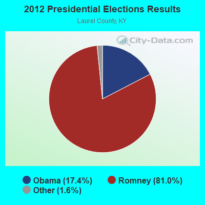

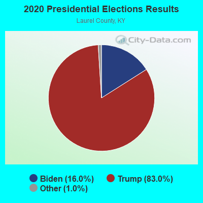
Graphs represent county-level data. Detailed 2008 Election Results
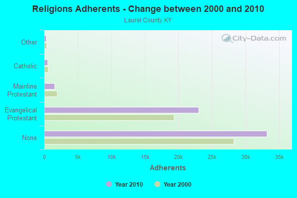
Religion statistics for Bush, KY (based on Laurel County data)
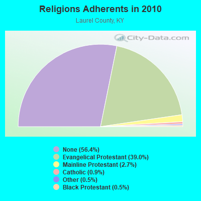
| Religion | Adherents | Congregations |
|---|---|---|
| Evangelical Protestant | 22,963 | 80 |
| Mainline Protestant | 1,579 | 8 |
| Catholic | 512 | 1 |
| Other | 309 | 2 |
| Black Protestant | 290 | 2 |
| None | 33,196 | - |
Food Environment Statistics:
| Laurel County: | 2.79 / 10,000 pop. |
| Kentucky: | 2.19 / 10,000 pop. |
| This county: | 0.35 / 10,000 pop. |
| Kentucky: | 0.25 / 10,000 pop. |
| Laurel County: | 0.17 / 10,000 pop. |
| Kentucky: | 0.74 / 10,000 pop. |
| This county: | 5.06 / 10,000 pop. |
| Kentucky: | 4.36 / 10,000 pop. |
| Laurel County: | 5.23 / 10,000 pop. |
| Kentucky: | 5.74 / 10,000 pop. |
| Here: | 13.0% |
| State: | 11.0% |
| Laurel County: | 35.1% |
| Kentucky: | 30.0% |
| This county: | 18.5% |
| Kentucky: | 15.9% |
Strongest AM radio stations in Bush:
- WKLB (1290 AM; 5 kW; MANCHESTER, KY; Owner: BARKER BROADCASTING COMPANY, INC.)
- WKDP (1330 AM; 5 kW; CORBIN, KY; Owner: EUBANKS BROADCASTING, INC.)
- WFTG (1400 AM; 1 kW; LONDON, KY; Owner: F.T.G. BROADCASTING, INC.)
- WKVL (850 AM; daytime; 50 kW; KNOXVILLE, TN; Owner: HORNE RADIO, LLC)
- WEKC (710 AM; daytime; 4 kW; WILLIAMSBURG, KY; Owner: GERALD PARKS)
- WGWM (980 AM; 1 kW; LONDON, KY; Owner: WGWM BROADCASTING, INC.)
- WCTT (680 AM; 1 kW; CORBIN, KY; Owner: ENCORE COMMUNICATIONS, INC)
- WWXL (1450 AM; 1 kW; MANCHESTER, KY; Owner: THE PROMISE PARTNERSHIP)
- WHAS (840 AM; 50 kW; LOUISVILLE, KY; Owner: CLEAR CHANNEL BROADCASTING LICENSES, INC.)
- WFSR (970 AM; 5 kW; HARLAN, KY; Owner: EASTERN BROADCASTING COMPAY)
- WMTC (730 AM; 5 kW; VANCLEVE, KY; Owner: THE KENTUCKY MOUNTAIN HOLINESS ASSN.)
- WMIK (560 AM; 2 kW; MIDDLESBORO, KY; Owner: GATEWAY BROADCASTING, INC.)
- WEKG (810 AM; daytime; 5 kW; JACKSON, KY; Owner: INTERMOUNTAIN B/CING CO., INC.)
Strongest FM radio stations in Bush:
- WYGE (92.3 FM; LONDON, KY; Owner: ETHEL HUFF BROADCASTING, LLC)
- WWEL (103.9 FM; LONDON, KY; Owner: F.T.G. BROADCASTING, INC.)
- WKDP-FM (99.5 FM; CORBIN, KY; Owner: EUBANKS BROADCASTING, INC.)
- WWLT (103.1 FM; MANCHESTER, KY; Owner: VERNON R. BALDWIN, INC.)
- WTBK (105.7 FM; MANCHESTER, KY; Owner: MANCHESTER COMMUNICATIONS, INC.)
- WVCT (91.5 FM; KEAVY, KY; Owner: VICTORY TRAINING SCHOOL CORP.)
- WCTT-FM (107.3 FM; CORBIN, KY; Owner: ENCORE COMMUNICATIONS, INC.)
- WMIK-FM (92.7 FM; MIDDLESBORO, KY; Owner: GATEWAY BROADCASTING, INC.)
- WEKX (102.7 FM; JELLICO, TN; Owner: WHITLEY BROADCASTING CO., INC.)
- WRIL (106.3 FM; PINEVILLE, KY; Owner: PINE HILLS BROADCASTING, INC.)
- WSGS (101.1 FM; HAZARD, KY; Owner: MOUNTAIN BROADCASTING SERVICE, INC.)
- WSEH (102.7 FM; CUMBERLAND, KY; Owner: CUMBERLAND CITY BROADCASTING, INC.)
- WEZJ-FM (104.3 FM; WILLIAMSBURG, KY; Owner: WHITLEY BROADCASTING CO., INC.)
- WTUK (105.1 FM; HARLAN, KY; Owner: EASTERN BROADCASTING COMPANY)
- WZQQ (97.9 FM; HYDEN, KY; Owner: LESLIE COUNTY BROADCASTING, INC.)
- WWAG (107.9 FM; MCKEE, KY; Owner: DANDY BROADCASTING, INC.)
- WKKQ (96.1 FM; BARBOURVILLE, KY; Owner: BARBOURVILLE COMMUNITY B/NG CO.INC.)
- WJMD (104.7 FM; HAZARD, KY; Owner: HAZARD BROADCASTING SERVICES)
- WEKH (90.9 FM; HAZARD, KY; Owner: EASTERN KENTUCKY UNIVERSITY)
- WLLK (93.9 FM; BURNSIDE, KY; Owner: CAPSTAR TX LIMITED PARTNERSHIP)
TV broadcast stations around Bush:
- WVTN-LP (Channel 48; CORBIN, KY; Owner: VICTORY TRAINING SCHOOL CORP.)
- WOBZ-LP (Channel 9; EAST BERNSTADT, ETC., KY; Owner: ANDREA JOY KESLER)
- W26BK (Channel 26; TALBERT, KY; Owner: MS COMMUNICATIONS, LLC)
- W39CK (Channel 20; CORBIN, KY; Owner: DEREK RAY EUBANKS)
- W33BK (Channel 33; CORBIN, KY; Owner: TRINITY BROADCASTING NETWORK)
- WLJC-TV (Channel 65; BEATTYVILLE, KY; Owner: HOUR OF HARVEST, INC.)
- W16BI (Channel 16; TALBERT, KY; Owner: MS COMMUNICATIONS, LLC)
- WYMT-TV (Channel 57; HAZARD, KY; Owner: WYMT LICENSEE CORP.)
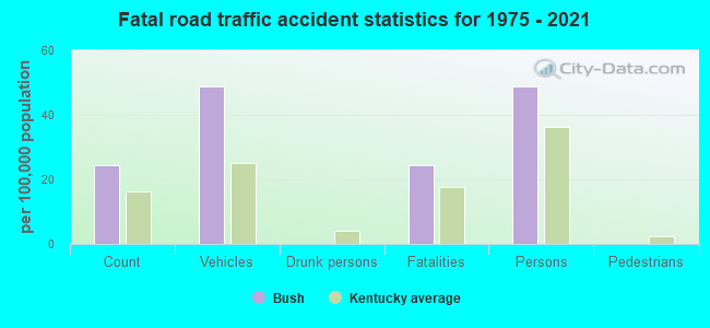
Bush fatal accident list:
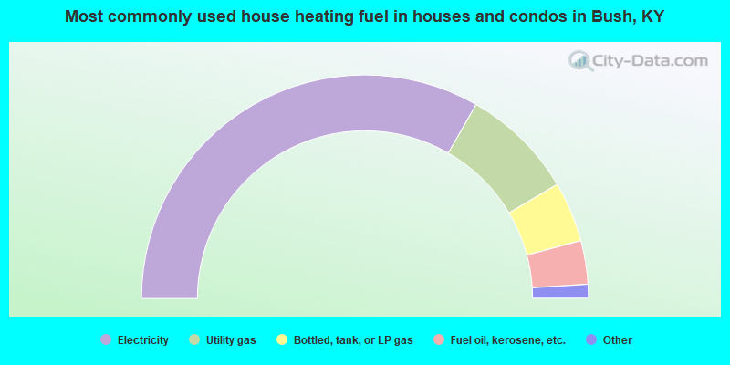
- 66.5%Electricity
- 16.4%Utility gas
- 8.7%Bottled, tank, or LP gas
- 6.3%Fuel oil, kerosene, etc.
- 0.8%Coal or coke
- 0.7%Other fuel
- 0.4%Wood
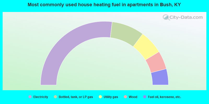
- 53.8%Electricity
- 16.5%Bottled, tank, or LP gas
- 12.1%Utility gas
- 9.3%Wood
- 8.2%Fuel oil, kerosene, etc.
Bush compared to Kentucky state average:
- Unemployed percentage significantly below state average.
- Black race population percentage significantly below state average.
- Hispanic race population percentage significantly below state average.
- Median age below state average.
- Foreign-born population percentage significantly below state average.
- Renting percentage below state average.
- Length of stay since moving in significantly above state average.
- Number of rooms per house significantly below state average.
- House age significantly below state average.