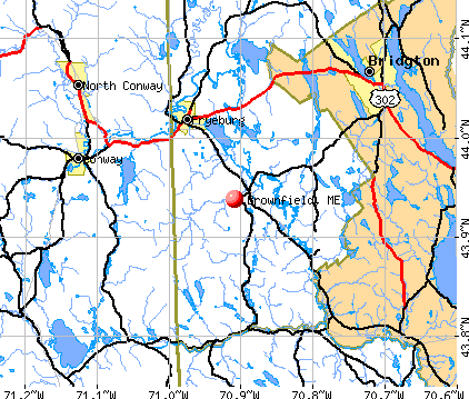
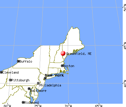
Brownfield, Maine
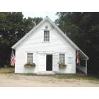
Brownfield: Brownfield Historical Society & Museum
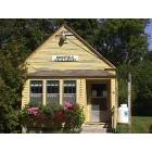
Brownfield: Brownfield Public Library
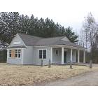
Brownfield: Brownfield Public Library after the move with new wing added, but still under construction
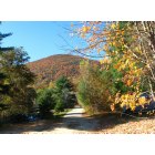
Brownfield: Burnt Meadow Mountain from Swan Rd.
Brownfield: outlet from Burnt Meadow Pond. on Burnt Meadow Road

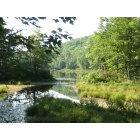
Brownfield: Burnt Meadow Pond at the public beach area

Brownfield: The winter sun over the Burnt Meadow Mountains

Brownfield: Run Goat Run!!
- add
your
Submit your own pictures of this town and show them to the world
- OSM Map
- General Map
- Google Map
- MSN Map
Population change since 2000: +27.7%
| Males: 804 | |
| Females: 793 |
| Median resident age: | 44.8 years |
| Maine median age: | 43.0 years |
Zip codes: 04010.
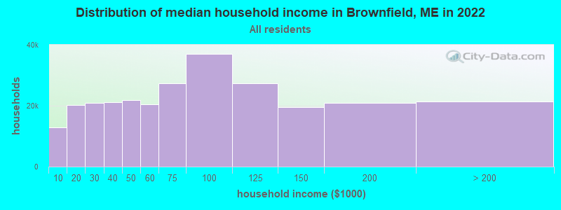
| Brownfield: | $55,598 |
| ME: | $69,543 |
Estimated per capita income in 2022: $30,311 (it was $16,037 in 2000)
Brownfield town income, earnings, and wages data
Estimated median house or condo value in 2022: $228,958 (it was $87,600 in 2000)
| Brownfield: | $228,958 |
| ME: | $290,600 |
Mean prices in 2022: all housing units: $258,607; detached houses: $254,021; townhouses or other attached units: $393,466; in 2-unit structures: $184,786; in 3-to-4-unit structures: $229,715; in 5-or-more-unit structures: $205,553; mobile homes: $333,480; occupied boats, rvs, vans, etc.: $32,243
Detailed information about poverty and poor residents in Brownfield, ME

Compare current foreclosures near Brownfield, ME:
| Photo | Address | Area | Beds / Baths | Price | Details |
|---|---|---|---|---|---|

|
#1
Cram Rd
East Baldwin, ME 04024
|
982 sq. feet
|
1 baths 2 beds |
show details | |

|
#2
Pequawket Dr
Conway, NH 03818
|
1,008 sq. feet
|
1 baths 2 beds |
show details | |

|
#3
Fein Ln
Center Conway, NH 03813
|
1,040 sq. feet
|
1 baths 3 beds |
show details | |

|
#4
Fein Lane A/k/a 26 Fein Lane
Center Conway, NH Array
|
952 sq. feet
|
1 baths 3 beds |
show details | |

|
#5
Henry Cotton Rd
Center Conway, NH 03813
|
1,792 sq. feet
|
2 baths 3 beds |
show details | |

|
#6
Portland St
Fryeburg, ME 04037
|
600 sq. feet
|
- baths - beds |
show details | |

|
#7
Colonial Cir
Harrison, ME 04040
|
- sq. feet
|
- baths - beds |
show details | |

|
#8
Old Colony Rd
Conway, NH 03818
|
- sq. feet
|
- baths - beds |
show details | |

|
#9
Smith Ave # 1
Bridgton, ME 04009
|
- sq. feet
|
- baths - beds |
show details | |

|
#10
Pleasant St
Conway, NH 03818
|
- sq. feet
|
- baths - beds |
show details |
| Photo | Address | Area | Beds / Baths | Price | Details |
|---|---|---|---|---|---|

|
#11
Fein Ln
Conway, NH 03818
|
- sq. feet
|
- baths - beds |
show details | |

|
#12
Black Bear Rd
Fryeburg, ME 04037
|
1,296 sq. feet
|
- baths - beds |
show details | |

|
#13
Cape Rd
Limington, ME 04049
|
- sq. feet
|
- baths - beds |
show details | |

|
#14
Tall Pines Ln
Parsonsfield, ME 04047
|
- sq. feet
|
- baths - beds |
show details | |

|
#15
Sebago Rd
Sebago, ME 04029
|
- sq. feet
|
- baths - beds |
show details | |

|
#16
Blake Hill Rd
Center Conway, NH 03813
|
- sq. feet
|
- baths - beds |
show details | |

|
#17
Wilkinson Swamp Rd
Effingham, NH 03882
|
- sq. feet
|
- baths - beds |
show details | |

|
Check over 1 million property listings on Foreclosure.com!
|
browse all offers | |||

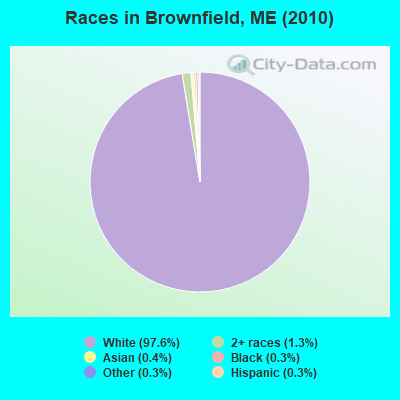
- 1,55897.6%White alone
- 201.3%Two or more races
- 60.4%Asian alone
- 40.3%Black alone
- 40.3%Other race alone
- 40.3%Hispanic
- 10.06%Native Hawaiian and Other
Pacific Islander alone
Races in Brownfield detailed stats: ancestries, foreign born residents, place of birth
According to our research of Maine and other state lists, there were 3 registered sex offenders living in Brownfield, Maine as of May 08, 2024.
The ratio of all residents to sex offenders in Brownfield is 532 to 1.
The ratio of registered sex offenders to all residents in this city is near the state average.
 Recent articles from our blog. Our writers, many of them Ph.D. graduates or candidates, create easy-to-read articles on a wide variety of topics.

 | Long Lake (6 replies) |
| Are there vampires? (29 replies) |
| Possibly relocating to Bridgton area. (23 replies) |
| Help Buying a House? (197 replies) |
| mosquitoes (25 replies) |
| Find Me a Town (39 replies) |
Latest news from Brownfield, ME collected exclusively by city-data.com from local newspapers, TV, and radio stations
Ancestries: English (20.1%), Irish (18.1%), French (9.4%), United States (8.6%), Italian (7.4%), German (6.7%).
Current Local Time: EST time zone
Incorporated on 02/20/1802
Elevation: 424 feet
Land area: 44.9 square miles.
Population density: 36 people per square mile (very low).
18 residents are foreign born
| This town: | 1.4% |
| Maine: | 2.9% |
| Brownfield town: | 1.5% ($1,349) |
| Maine: | 1.5% ($1,417) |
Nearest city with pop. 50,000+: Portland, ME  (36.8 miles , pop. 64,249).
Nearest city with pop. 200,000+: Boston, MA (112.3 miles , pop. 589,141).
Nearest city with pop. 1,000,000+: Bronx, NY (262.3 miles , pop. 1,332,650).
Nearest cities:
), ), Latitude: 43.94 N, Longitude: 70.90 W
Area code commonly used in this area: 207

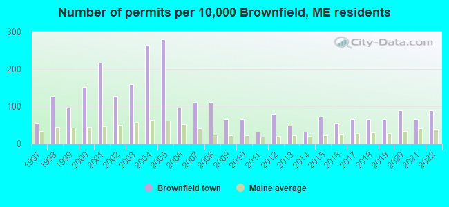
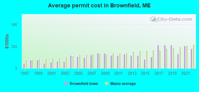
Single-family new house construction building permits:
- 2022: 11 buildings, average cost: $229,200
- 2021: 8 buildings, average cost: $259,200
- 2020: 11 buildings, average cost: $167,300
- 2019: 8 buildings, average cost: $268,800
- 2018: 8 buildings, average cost: $268,800
- 2017: 8 buildings, average cost: $268,800
- 2016: 7 buildings, average cost: $132,700
- 2015: 9 buildings, average cost: $105,600
- 2014: 4 buildings, average cost: $150,000
- 2013: 6 buildings, average cost: $150,000
- 2012: 10 buildings, average cost: $163,500
- 2011: 4 buildings, average cost: $150,000
- 2010: 8 buildings, average cost: $150,000
- 2009: 8 buildings, average cost: $175,000
- 2008: 14 buildings, average cost: $175,000
- 2007: 14 buildings, average cost: $153,400
- 2006: 12 buildings, average cost: $125,000
- 2005: 35 buildings, average cost: $136,500
- 2004: 33 buildings, average cost: $150,000
- 2003: 20 buildings, average cost: $81,500
- 2002: 16 buildings, average cost: $82,900
- 2001: 27 buildings, average cost: $75,100
- 2000: 19 buildings, average cost: $60,100
- 1999: 12 buildings, average cost: $98,700
- 1998: 16 buildings, average cost: $98,500
- 1997: 7 buildings, average cost: $60,100
| Here: | 2.5% |
| Maine: | 3.4% |
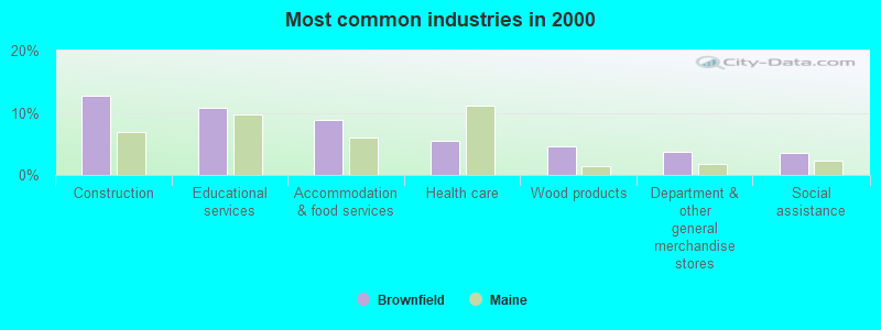
- Construction (12.8%)
- Educational services (10.8%)
- Accommodation & food services (8.8%)
- Health care (5.5%)
- Wood products (4.7%)
- Department & other general merchandise stores (3.7%)
- Social assistance (3.5%)
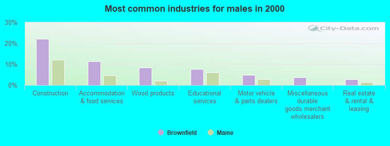
- Construction (22.1%)
- Accommodation & food services (11.4%)
- Wood products (8.3%)
- Educational services (7.6%)
- Motor vehicle & parts dealers (4.8%)
- Miscellaneous durable goods merchant wholesalers (3.8%)
- Real estate & rental & leasing (2.8%)
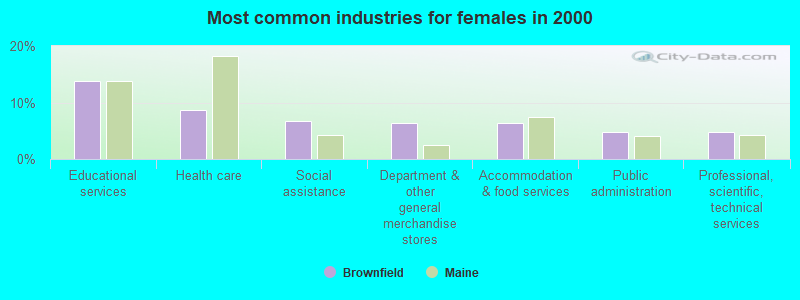
- Educational services (13.8%)
- Health care (8.7%)
- Social assistance (6.7%)
- Department & other general merchandise stores (6.4%)
- Accommodation & food services (6.4%)
- Public administration (4.8%)
- Professional, scientific, technical services (4.8%)

- Other sales and related occupations, including supervisors (6.2%)
- Carpenters (6.0%)
- Retail sales workers, except cashiers (5.3%)
- Secretaries and administrative assistants (4.3%)
- Building and grounds cleaning and maintenance occupations (4.3%)
- Preschool, kindergarten, elementary, and middle school teachers (3.2%)
- Material recording, scheduling, dispatching, and distributing workers (3.0%)
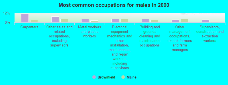
- Carpenters (11.4%)
- Other sales and related occupations, including supervisors (7.6%)
- Metal workers and plastic workers (4.8%)
- Electrical equipment mechanics and other installation, maintenance, and repair workers, including supervisors (4.5%)
- Building and grounds cleaning and maintenance occupations (4.5%)
- Other management occupations, except farmers and farm managers (3.8%)
- Supervisors, construction and extraction workers (3.8%)

- Retail sales workers, except cashiers (9.3%)
- Secretaries and administrative assistants (8.3%)
- Preschool, kindergarten, elementary, and middle school teachers (4.8%)
- Other sales and related occupations, including supervisors (4.8%)
- Supervisors and other personal care and service workers, except child care workers (4.8%)
- Registered nurses (4.2%)
- Building and grounds cleaning and maintenance occupations (4.2%)
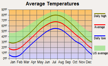
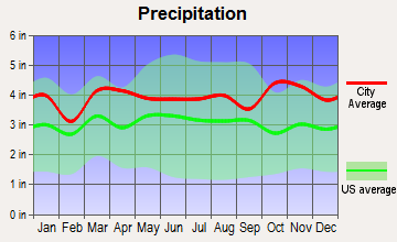
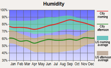
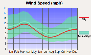
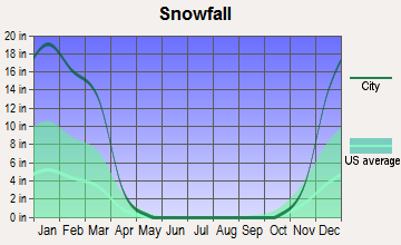
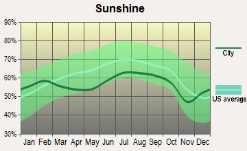
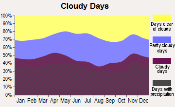
Average climate in Brownfield, Maine
Based on data reported by over 4,000 weather stations
(lower is better)
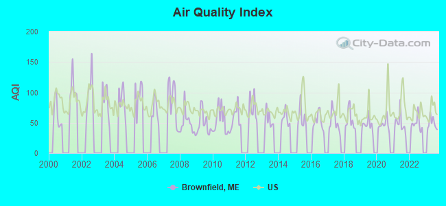
Air Quality Index (AQI) level in 2023 was 48.8. This is significantly better than average.
| City: | 48.8 |
| U.S.: | 72.6 |
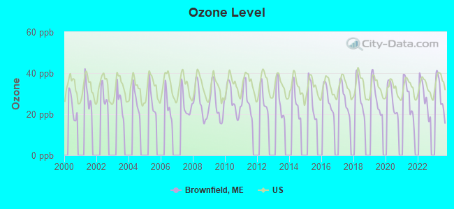
Ozone [ppb] level in 2023 was 29.7. This is about average. Closest monitor was 11.9 miles away from the city center.
| City: | 29.7 |
| U.S.: | 33.3 |
Tornado activity:
Brownfield-area historical tornado activity is above Maine state average. It is 75% smaller than the overall U.S. average.
On 7/18/1963, a category F2 (max. wind speeds 113-157 mph) tornado 27.8 miles away from the Brownfield town center caused between $5000 and $50,000 in damages.
On 10/10/1966, a category F2 tornado 35.7 miles away from the town center caused between $5000 and $50,000 in damages.
Earthquake activity:
Brownfield-area historical earthquake activity is significantly above Maine state average. It is 73% smaller than the overall U.S. average.On 4/20/2002 at 10:50:47, a magnitude 5.3 (5.3 ML, Depth: 3.0 mi, Class: Moderate, Intensity: VI - VII) earthquake occurred 144.2 miles away from Brownfield center
On 10/16/2012 at 23:12:25, a magnitude 4.7 (4.7 ML, Depth: 10.0 mi, Class: Light, Intensity: IV - V) earthquake occurred 26.6 miles away from the city center
On 4/20/2002 at 10:50:47, a magnitude 5.2 (5.2 MB, 4.2 MS, 5.2 MW, 5.0 MW) earthquake occurred 144.7 miles away from Brownfield center
On 10/7/1983 at 10:18:46, a magnitude 5.3 (5.1 MB, 5.3 LG, 5.1 ML) earthquake occurred 171.4 miles away from the city center
On 1/19/1982 at 00:14:42, a magnitude 4.7 (4.5 MB, 4.7 MD, 4.5 LG) earthquake occurred 46.3 miles away from Brownfield center
On 8/21/1996 at 07:54:14, a magnitude 3.8 (3.8 LG, 3.6 LG, Depth: 6.2 mi, Class: Light, Intensity: II - III) earthquake occurred 28.1 miles away from Brownfield center
Magnitude types: regional Lg-wave magnitude (LG), body-wave magnitude (MB), duration magnitude (MD), local magnitude (ML), surface-wave magnitude (MS), moment magnitude (MW)
Natural disasters:
The number of natural disasters in Oxford County (31) is a lot greater than the US average (15).Major Disasters (Presidential) Declared: 23
Emergencies Declared: 7
Causes of natural disasters: Floods: 19, Storms: 16, Snows: 7, Hurricanes: 3, Heavy Rains: 2, Blizzard: 1, Ice Storm: 1, Landslide: 1, Mudslide: 1, Snowfall: 1, Tropical Storm: 1, Wind: 1, Winter Storm: 1, Other: 2 (Note: some incidents may be assigned to more than one category).
Hospitals and medical centers near Brownfield:
- HICKS NURSING HOME (Nursing Home, about 7 miles away; FRYEBURG, ME)
- FRYEBURG HEALTH CARE CENTER (Nursing Home, about 7 miles away; FRYEBURG, ME)
- MERRIMAN HOUSE (Nursing Home, about 12 miles away; NORTH CONWAY, NH)
- MINERAL SPRINGS OF NORTH CONWAY CARE AND REHABILIT (Nursing Home, about 12 miles away; NORTH CONWAY, NH)
- BRIDGTON HEALTH CARE CENTER (Nursing Home, about 13 miles away; BRIDGTON, ME)
- VN AND HSP CARE SVC OF N CAR CTY (Home Health Center, about 14 miles away; NORTH CONWAY, NH)
Colleges/universities with over 2000 students nearest to Brownfield:
- Saint Joseph's College of Maine (about 23 miles; Standish, ME; Full-time enrollment: 2,010)
- University of Southern Maine (about 37 miles; Portland, ME; FT enrollment: 6,647)
- Southern Maine Community College (about 40 miles; South Portland, ME; FT enrollment: 4,666)
- Plymouth State University (about 42 miles; Plymouth, NH; FT enrollment: 4,838)
- University of New England (about 43 miles; Biddeford, ME; FT enrollment: 4,539)
- University of New Hampshire-Main Campus (about 56 miles; Durham, NH; FT enrollment: 15,243)
- NHTI-Concord's Community College (about 59 miles; Concord, NH; FT enrollment: 2,865)
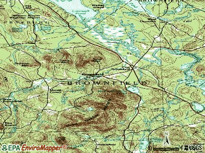
Points of interest:
Notable location: Brownfield Volunteer Fire Department (A). Display/hide its location on the map
Church in Brownfield: Brownfield Community Church (A). Display/hide its location on the map
Cemeteries: Merrill Cemetery (1), Marston Cemetery (2), Wentworth Cemetery (3), Walker Rounds Cemetery (4), Hartford Cemetery (5), Blake Cemetery (6), Brown Cemetery (7). Display/hide their locations on the map
Lakes and reservoirs: Dyer Pond (A), Pequawket Pond (B), Tenmile Pond (C), Mill Pond (D), Burnt Meadow Pond (E). Display/hide their locations on the map
Streams, rivers, and creeks: Tenmile River (A), Quint Brook (B), Durgin Brook (C), Haley Brook (D), Burnt Meadow Brook (E), Billy Brook (F). Display/hide their locations on the map
Tourist attraction: Allan Comeau Dba-A New England MTN Guide (Tours & Charters; 97 Center Conway Road) (1). Display/hide its approximate location on the map
Birthplace of: Paris Gibson - Politician.
Drinking water stations with addresses in Brownfield and their reported violations in the past:
WOODLAND ACRES CAMPGROUND-PLAYGROUND (Population served: 295, Groundwater):Past monitoring violations:STONE MOUNTAIN ARTS & CAFE (Population served: 185, Groundwater):
- 3 regular monitoring violations
Past health violations:SHANNONS SACO RIVER SANCTUARY (Address: 279 DENMARK ROAD , Population served: 110, Groundwater):Past monitoring violations:
- MCL, Single Sample - Between JAN-2006 and DEC-2006, Contaminant: Combined Uranium. Follow-up actions: St Violation/Reminder Notice (AUG-25-2006), St Intentional no-action (FEB-16-2007), St Compliance achieved (AUG-17-2011)
- 8 routine major monitoring violations
- 4 regular monitoring violations
Past monitoring violations:THE BACK BURNER RESTAURANT (Population served: 60, Groundwater):
- 2 routine major monitoring violations
Past monitoring violations:DEPOT STREET DINER (Population served: 50, Groundwater):
- 2 routine major monitoring violations
Past monitoring violations:
- 6 routine major monitoring violations
- 6 regular monitoring violations
Drinking water stations with addresses in Brownfield that have no violations reported:
- RIVER RUN CAMPGROUND (Population served: 55, Primary Water Source Type: Groundwater)
- WOODLAND ACRES CAMPGROUND- FIELD WELL (Population served: 25, Primary Water Source Type: Groundwater)
| This town: | 2.4 people |
| Maine: | 2.3 people |
| This town: | 68.4% |
| Whole state: | 62.9% |
| This town: | 9.4% |
| Whole state: | 9.4% |
Likely homosexual households (counted as self-reported same-sex unmarried-partner households)
- Lesbian couples: 0.3% of all households
- Gay men: 0.2% of all households
| This town: | 8.6% |
| Whole state: | 10.9% |
| This town: | 2.9% |
| Whole state: | 4.1% |
For population 15 years and over in Brownfield:
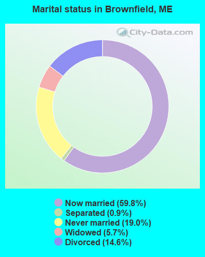
- Never married: 19.0%
- Now married: 59.8%
- Separated: 0.9%
- Widowed: 5.7%
- Divorced: 14.6%
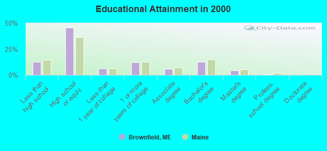
For population 25 years and over in Brownfield:
- High school or higher: 87.4%
- Bachelor's degree or higher: 17.5%
- Graduate or professional degree: 4.8%
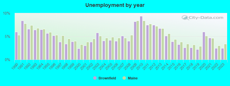
- Unemployed: 6.2%
- Mean travel time to work (commute): 27.5 minutes
| Here: | 9.2 |
| Maine average: | 11.2 |
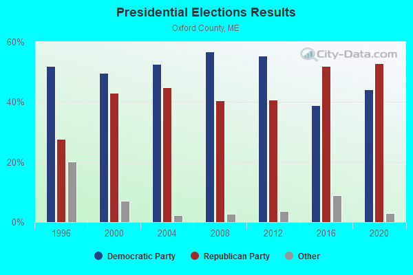
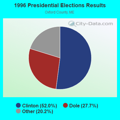
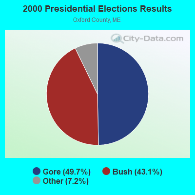
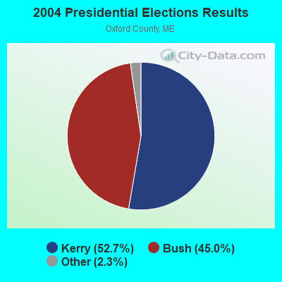


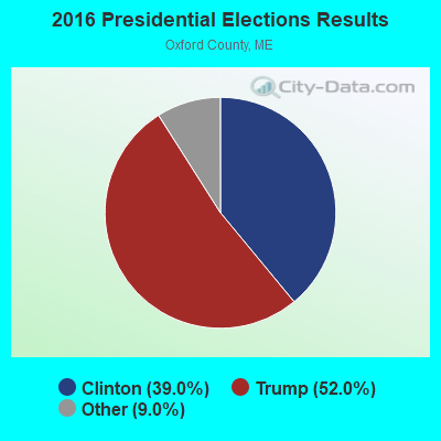

Graphs represent county-level data. Detailed 2008 Election Results
Religion statistics for Brownfield, ME (based on Oxford County data)
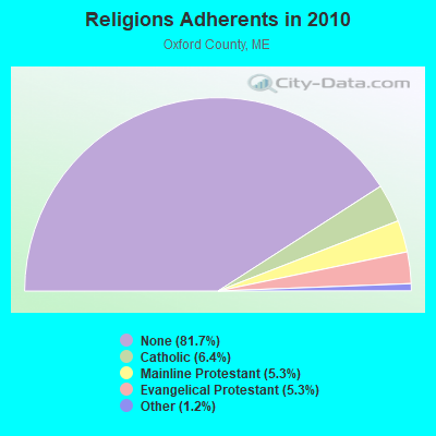
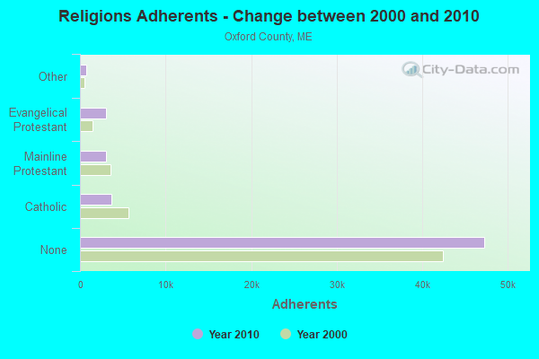
| Religion | Adherents | Congregations |
|---|---|---|
| Catholic | 3,708 | 7 |
| Mainline Protestant | 3,085 | 45 |
| Evangelical Protestant | 3,045 | 37 |
| Other | 719 | 14 |
| None | 47,276 | - |
Food Environment Statistics:
| Here: | 2.47 / 10,000 pop. |
| Maine: | 2.80 / 10,000 pop. |
| Oxford County: | 0.35 / 10,000 pop. |
| State: | 0.14 / 10,000 pop. |
| Here: | 2.29 / 10,000 pop. |
| Maine: | 2.20 / 10,000 pop. |
| Oxford County: | 7.94 / 10,000 pop. |
| State: | 5.75 / 10,000 pop. |
| This county: | 9.35 / 10,000 pop. |
| State: | 11.02 / 10,000 pop. |
| Oxford County: | 7.6% |
| State: | 8.2% |
| This county: | 25.6% |
| Maine: | 25.0% |
Strongest AM radio stations in Brownfield:
- WMTW (870 AM; 10 kW; GORHAM, ME; Owner: RADIO PARTNERS OF MAINE, L.P.)
- WBNC (1050 AM; 1 kW; CONWAY, NH; Owner: MT. WASHINGTON RADIO & GRAMOPHONE, L.L.C.)
- WGAN (560 AM; 5 kW; PORTLAND, ME; Owner: SAGA COMMUNICATIONS OF NEW ENGLAND, LLC)
- WRKO (680 AM; 50 kW; BOSTON, MA; Owner: ENTERCOM BOSTON LICENSE, LLC)
- WTME (780 AM; 10 kW; RUMFORD, ME; Owner: MOUNTAIN VALLEY BROADCASTING, INC.)
- WGIN (930 AM; 10 kW; ROCHESTER, NH; Owner: CAPSTAR TX LIMITED PARTNERSHIP)
- WASR (1420 AM; 5 kW; WOLFEBORO, NH; Owner: RADIO WOLFEBORO, INC.)
- WEEI (850 AM; 50 kW; BOSTON, MA; Owner: ENTERCOM BOSTON LICENSE, LLC)
- WZAN (970 AM; 5 kW; PORTLAND, ME; Owner: SAGA COMMUNICATIONS OF NEW ENGLAND, LLC)
- WBZ (1030 AM; 50 kW; BOSTON, MA; Owner: INFINITY BROADCASTING OPERATIONS, INC.)
- WCRN (830 AM; 50 kW; WORCESTER, MA; Owner: CARTER BROADCASTING CORPORATION)
- WJAE (1440 AM; 5 kW; WESTBROOK, ME; Owner: ALTANTIC COAST RADIO, LLC)
- WLOB (1310 AM; 5 kW; PORTLAND, ME; Owner: ATLANTIC COAST RADIO, LLC)
Strongest FM radio stations in Brownfield:
- WMEA (90.1 FM; PORTLAND, ME; Owner: MAINE PUBLIC BROADCASTING CORPORATION)
- WPKQ (103.7 FM; NORTH CONWAY, NH; Owner: CITADEL BROADCASTING COMPANY)
- WHOM (94.9 FM; MT. WASHINGTON, NH; Owner: CITADEL BROADCASTING COMPANY)
- WSCY (106.9 FM; MOULTONBOROUGH, NH; Owner: NORTHEAST COMMUNICATIONS CORPORATION)
- WBLM (102.9 FM; PORTLAND, ME; Owner: CITADEL BROADCASTING COMPANY)
- WVFM (105.7 FM; CAMPTON, NH; Owner: DEVON BROADCASTING COMPANY, INC.)
- WVMJ (104.5 FM; CONWAY, NH; Owner: MT. WASHINGTON RADIO & GRAMOPHONE, L.L.C.)
- WMWV (93.5 FM; CONWAY, NH; Owner: MT. WASHINGTON RADIO & GRAMOPHONE, L.L.C.)
- WTHT (107.5 FM; LEWISTON, ME; Owner: RADIO PARTNERS OF MAINE, L.P.)
- WJBQ (97.9 FM; PORTLAND, ME; Owner: CITADEL BROADCASTING COMPANY)
- WLOB-FM (96.3 FM; RUMFORD, ME; Owner: ATLANTIC COAST RADIO, LLC)
- WLKZ (104.9 FM; WOLFEBORO, NH; Owner: TELE-MEDIA COMPANY OF NEW HAMPSHIRE, L.L.C.)
- WTBM (100.7 FM; MEXICO, ME; Owner: MOUNTAIN VALLEY BROADCASTING, INC.)
- WPNH-FM (100.1 FM; PLYMOUTH, NH; Owner: NORTHEAST COMMUNICATIONS CORPORATION)
- WMTW-FM (106.7 FM; NORTH WINDHAM, ME; Owner: RADIO PARTNERS OF MAINE, L.P.)
- WMEK-FM (99.9 FM; AUBURN, ME; Owner: RADIO PARTNERS OF MAINE, L.P.)
- WPOR (101.9 FM; PORTLAND, ME; Owner: SAGA COMMUNICATIONS OF NEW ENGLAND, LLC)
- WMSJ (89.3 FM; FREEPORT, ME; Owner: DOWNEAST CHRISTIAN COMMUNICATIONS)
- WOXO-FM (92.7 FM; NORWAY, ME; Owner: TRI-COUNTY BROADCASTING, INC.)
TV broadcast stations around Brownfield:
- WMTW-TV (Channel 8; POLAND SPRING, ME; Owner: WMTW BROADCAST GROUP, LLC)
- WCSH (Channel 6; PORTLAND, ME; Owner: PACIFIC AND SOUTHERN COMPANY, INC.)
- WGME-TV (Channel 13; PORTLAND, ME; Owner: WGME LICENSEE, LLC)
- WMEA-TV (Channel 26; BIDDEFORD, ME; Owner: MAINE PUBLIC BROADCASTING CORP.)
- WPXT (Channel 51; PORTLAND, ME; Owner: HMW, INC.)
- WPME (Channel 35; LEWISTON, ME; Owner: KB PRIME MEDIA LLC)
- W32CA (Channel 32; PORTLAND, ME; Owner: NATIONAL MINORITY T.V., INC.)
- Brownfield, Maine
- Fatal accident count11
- Vehicles involved in fatal accidents15
- Fatal accidents involving drunk persons:6
- Fatalities12
- Persons involved in fatal accidents19
- Pedestrians involved in fatal accidents0
- Maine average
- Fatal accident count1619
- Vehicles involved in fatal accidents2308
- Fatal accidents involving drunk persons564
- Fatalities1786
- Persons involved in fatal accidents3696
- Pedestrians involved in fatal accidents164
- National Bridge Inventory (NBI) Statistics
- 6Number of bridges
- 49ft / 15.3mTotal length
- 10,856Total average daily traffic
- 541Total average daily truck traffic
- 13,310Total future (year 2036) average daily traffic
FCC Registered Antenna Towers:
7- Mark L Gartley, 79 Pease Lane (Lat: 43.937722 Lon: -70.867083), Type: 47.2, Overall height: 45.7 m, Registrant: United States Cellular Corporation, Renee.Mazur@uscellular.Com, , Chica-go, Phone: (773) 399-8900
- Mark L Gartley, 79 Pease Lane (Lat: 43.937722 Lon: -70.867083), Type: 47.2, Overall height: 45.7 m, Registrant: Holland & Knight LLP, Pconnolly@hklaw.Com, , Washi-ngton, Phone: (202) 862-5989
- Cayla Gamble, 79 Pease Lane (Lat: 43.937750 Lon: -70.867083), Type: 47.2, Structure height: 23017 m, Overall height: 45.7 m, Licensee ID: C, Registrant: United States Cellular Corporation, Regulatoryaffairs@uscellular.Com, , Chica-go, Phone: (800) 510-6091
- Cayla Gamble, 79 Pease Lane (Lat: 43.937750 Lon: -70.867083), Type: 47.2, Structure height: 23017 m, Overall height: 45.7 m, Registrant: Holland & Knight LLP, Peter.Connolly@hklaw.Com, , Washi-ngton, Phone: (202) 862-5989
- Cayla Gamble, 79 Pease Ln (Lat: 43.937750 Lon: -70.867083), Type: 47.2, Structure height: 23017 m, Overall height: 45.7 m, Registrant: Wilkinson Barker Knauer, LLP, Gwerner@wbklaw.Com, , Washi-ngton, Phone: (202) 383-3420
- Cayla Gamble, 79 Pease Ln (Lat: 43.937750 Lon: -70.867083), Type: 47.2, Structure height: 23017 m, Overall height: 45.7 m, Licensee ID: C, Registrant: United States Cellular Corporation, Regulatoryaffairs@uscellular.Com, , Chica-go, Phone: (800) 510-6091
- Cayla Gamble, 79 Pease Ln (Lat: 43.937750 Lon: -70.867083), Type: 47.2, Structure height: 23017 m, Overall height: 45.7 m, Registrant: Wilkinson Barker Knauer, LLP, Gwerner@wbklaw.Com, , Washi-ngton, Phone: (202) 383-3420
FCC Registered Amateur Radio Licenses:
14 (See the full list of FCC Registered Amateur Radio Licenses in Brownfield)FAA Registered Aircraft:
1- Aircraft: CESSNA 172M (Category: Land, Seats: 4, Weight: Up to 12,499 Pounds, Speed: 108 mph), Engine: 4 Cycle
N-Number: 119P, N119P, N-119P, Serial Number: 17263873, Certificate Issue Date: 07/17/2000
Registrant (Co-Owned): James R Meyers, Po Box 223, Brownfield, ME 04010, Other Owners: Constance E Harte
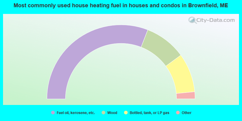
- 61.8%Fuel oil, kerosene, etc.
- 18.1%Wood
- 17.0%Bottled, tank, or LP gas
- 1.3%Solar energy
- 1.1%Utility gas
- 0.7%Electricity
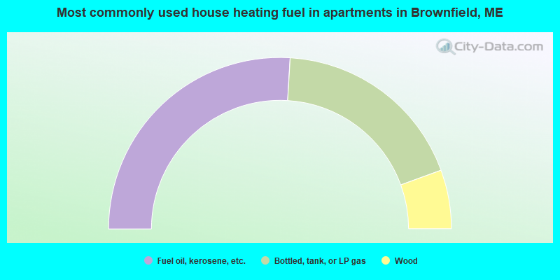
- 51.9%Fuel oil, kerosene, etc.
- 37.0%Bottled, tank, or LP gas
- 11.1%Wood
Brownfield compared to Maine state average:
- Unemployed percentage below state average.
- Black race population percentage significantly below state average.
- Hispanic race population percentage significantly below state average.
- Foreign-born population percentage significantly below state average.
- Renting percentage significantly below state average.
- Length of stay since moving in significantly above state average.
- Number of rooms per house significantly below state average.
- House age significantly below state average.
- Percentage of population with a bachelor's degree or higher below state average.

|
Total of 1 patent application in 2008-2024.