Brothertown, Wisconsin
Submit your own pictures of this town and show them to the world
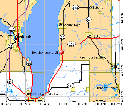
- OSM Map
- General Map
- Google Map
- MSN Map
Population change since 2000: -5.3%
| Males: 698 | |
| Females: 631 |
| Median resident age: | 43.2 years |
| Wisconsin median age: | 42.6 years |
Zip codes: 53014.
| Brothertown: | $78,206 |
| WI: | $70,996 |
Estimated per capita income in 2022: $38,125 (it was $19,816 in 2000)
Brothertown town income, earnings, and wages data
Estimated median house or condo value in 2022: $258,712 (it was $109,500 in 2000)
| Brothertown: | $258,712 |
| WI: | $252,800 |
Mean prices in 2022: all housing units: $260,489; detached houses: $265,602; townhouses or other attached units: $176,278; in 2-unit structures: $508,640; in 3-to-4-unit structures: $278,880; in 5-or-more-unit structures: $121,263; mobile homes: $28,072
Detailed information about poverty and poor residents in Brothertown, WI
Compare current foreclosures near Brothertown, WI:
| Photo | Address | Area | Beds / Baths | Price | Details |
|---|---|---|---|---|---|

|
#1
Ashland St
Oshkosh, WI 54901
|
1,982 sq. feet
|
1 baths 2 beds |
show details | |

|
#2
Knapp St
Oshkosh, WI 54902
|
1,040 sq. feet
|
1 baths 2 beds |
show details | |

|
#3
W 16th Ave
Oshkosh, WI 54902
|
1,196 sq. feet
|
1 baths 3 beds |
show details | |

|
#4
Dove St
Oshkosh, WI 54902
|
528 sq. feet
|
1 baths 1 beds |
show details | |

|
#5
Pleasant St
Oshkosh, WI 54901
|
1,529 sq. feet
|
1 baths 4 beds |
show details | |

|
#6
W 22nd Ave
Oshkosh, WI 54902
|
1,754 sq. feet
|
2 baths 3 beds |
show details | |

|
#7
Bowen St
Oshkosh, WI 54901
|
1,068 sq. feet
|
1 baths 3 beds |
show details | |

|
#8
W 23rd Ave
Oshkosh, WI 54902
|
1,048 sq. feet
|
2 baths 2 beds |
show details | |

|
#9
Zarling Ave
Oshkosh, WI 54901
|
1,640 sq. feet
|
1 baths 3 beds |
show details | |

|
#10
Sharratt Dr
Oshkosh, WI 54901
|
1,400 sq. feet
|
2 baths 3 beds |
show details |
| Photo | Address | Area | Beds / Baths | Price | Details |
|---|---|---|---|---|---|

|
#11
Sheridan St
Oshkosh, WI 54901
|
1,778 sq. feet
|
2 baths 3 beds |
show details | |

|
#12
S Sawyer St
Oshkosh, WI 54902
|
1,390 sq. feet
|
1 baths 2 beds |
show details | |

|
#13
Jefferson St
Oshkosh, WI 54901
|
1,350 sq. feet
|
1 baths 4 beds |
show details | |

|
#14
Frederick St
Oshkosh, WI 54901
|
1,730 sq. feet
|
2 baths 4 beds |
show details | |

|
#15
Ashland St
Oshkosh, WI 54901
|
1,185 sq. feet
|
1 baths 3 beds |
show details | |

|
#16
Alaska St
Oshkosh, WI 54902
|
1,040 sq. feet
|
1 baths 2 beds |
show details | |

|
#17
N Sawyer St
Oshkosh, WI 54902
|
1,446 sq. feet
|
1 baths 4 beds |
show details | |

|
#18
Mount Vernon St
Oshkosh, WI 54901
|
1,155 sq. feet
|
1 baths 2 beds |
show details | |

|
#19
W 15th Ave
Oshkosh, WI 54902
|
1,546 sq. feet
|
2 baths 3 beds |
show details | |

|
#20
Jefferson St
Oshkosh, WI 54901
|
1,157 sq. feet
|
1 baths 3 beds |
show details |
| Photo | Address | Area | Beds / Baths | Price | Details |
|---|---|---|---|---|---|

|
#21
Michigan St
Oshkosh, WI 54902
|
1,320 sq. feet
|
1 baths 2 beds |
show details | |

|
#22
Michigan St
Oshkosh, WI 54902
|
2,062 sq. feet
|
2 baths 4 beds |
show details | |

|
#23
Island Estates Ct
Oshkosh, WI 54901
|
1,816 sq. feet
|
2 baths 3 beds |
show details | |

|
#24
Ohio St
Oshkosh, WI 54902
|
1,357 sq. feet
|
1 baths 3 beds |
show details | |

|
#25
W 11th Ave
Oshkosh, WI 54902
|
1,976 sq. feet
|
2 baths 5 beds |
show details | |

|
#26
Dakota St
Oshkosh, WI 54902
|
1,172 sq. feet
|
2 baths 3 beds |
show details | |

|
#27
W Linwood Ave
Oshkosh, WI 54901
|
2,112 sq. feet
|
3 baths 6 beds |
show details | |

|
#28
Georgia St
Oshkosh, WI 54902
|
868 sq. feet
|
1 baths 2 beds |
show details | |

|
#29
W 18th Ave
Oshkosh, WI 54902
|
1,344 sq. feet
|
1 baths 3 beds |
show details | |

|
#30
W 5th Ave
Oshkosh, WI 54902
|
1,078 sq. feet
|
1 baths 3 beds |
show details |
| Photo | Address | Area | Beds / Baths | Price | Details |
|---|---|---|---|---|---|

|
#31
Ceape Ave
Oshkosh, WI 54901
|
1,712 sq. feet
|
1 baths 3 beds |
show details | |

|
#32
W 24th Ave
Oshkosh, WI 54902
|
1,050 sq. feet
|
1 baths 3 beds |
show details | |

|
#33
School Ave
Oshkosh, WI 54901
|
1,424 sq. feet
|
1 baths 4 beds |
show details | |

|
#34
Waugoo Ave
Oshkosh, WI 54901
|
1,915 sq. feet
|
1 baths 3 beds |
show details | |

|
#35
E Parkway Ave
Oshkosh, WI 54901
|
1,170 sq. feet
|
1 baths 2 beds |
show details | |

|
#36
Knapp St
Oshkosh, WI 54902
|
1,967 sq. feet
|
2 baths 5 beds |
show details | |

|
#37
S Eagle St
Oshkosh, WI 54902
|
1,176 sq. feet
|
1 baths 4 beds |
show details | |

|
#38
N Lark St
Oshkosh, WI 54902
|
1,092 sq. feet
|
1 baths 3 beds |
show details | |

|
#39
Jupiter Dr
Fond Du Lac, WI 54937
|
- sq. feet
|
- baths - beds |
show details | |

|
#40
Sullivan St Apt 10
Oshkosh, WI 54902
|
- sq. feet
|
- baths - beds |
show details |
| Photo | Address | Area | Beds / Baths | Price | Details |
|---|---|---|---|---|---|

|
#41
Indigo Dr
Oshkosh, WI 54902
|
- sq. feet
|
- baths - beds |
show details | |

|
#42
Harrison St # 15
Fond Du Lac, WI 54937
|
- sq. feet
|
- baths - beds |
show details | |

|
#43
Taft Ave Apt D2
Oshkosh, WI 54902
|
- sq. feet
|
- baths - beds |
show details | |

|
#44
E 1st St Apt 110
Fond Du Lac, WI 54935
|
- sq. feet
|
- baths - beds |
show details | |

|
#45
4th St
Fond Du Lac, WI 54935
|
- sq. feet
|
- baths - beds |
show details | |

|
#46
Vinland St
Oshkosh, WI 54901
|
- sq. feet
|
- baths - beds |
show details | |

|
#47
Lakeview
Fond Du Lac, WI 54937
|
- sq. feet
|
- baths - beds |
show details | |

|
#48
Sullivan St # 7
Oshkosh, WI 54902
|
- sq. feet
|
- baths - beds |
show details | |

|
#49
Marathon Ave Apt 8
Neenah, WI 54956
|
- sq. feet
|
- baths - beds |
show details | |

|
Check over 1 million property listings on Foreclosure.com!
|
browse all offers | |||

- 1,29097.1%White alone
- 272.0%Hispanic
- 50.4%American Indian alone
- 40.3%Two or more races
- 30.2%Black alone
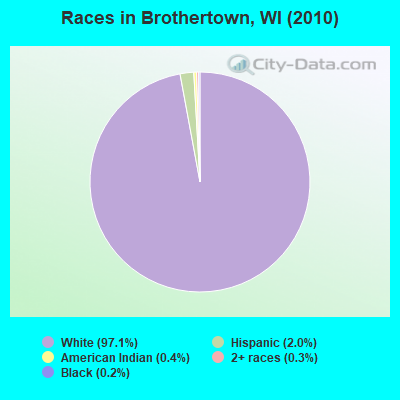
Races in Brothertown detailed stats: ancestries, foreign born residents, place of birth
 Recent articles from our blog. Our writers, many of them Ph.D. graduates or candidates, create easy-to-read articles on a wide variety of topics.

 | Wisconsin homestead? (12 replies) |
| Communities on the East Coast of Lake Winnebago (7 replies) |
Latest news from Brothertown, WI collected exclusively by city-data.com from local newspapers, TV, and radio stations
Ancestries: German (74.9%), Irish (7.1%), Polish (4.8%), French (2.5%), Dutch (2.1%), Norwegian (2.0%).
Current Local Time: CST time zone
Elevation: 810 feet
Land area: 36.8 square miles.
Population density: 36 people per square mile (very low).
14 residents are foreign born
| This town: | 1.0% |
| Wisconsin: | 3.6% |
| Brothertown town: | 1.7% ($1,808) |
| Wisconsin: | 2.0% ($2,245) |
Nearest city with pop. 50,000+: Oshkosh, WI  (15.3 miles , pop. 62,916).
Nearest city with pop. 200,000+: Milwaukee, WI (65.5 miles , pop. 596,974).
Nearest city with pop. 1,000,000+: Chicago, IL (150.4 miles , pop. 2,896,016).
Nearest cities:
), ), ), ), ), ), )Latitude: 43.97 N, Longitude: 88.25 W
Area code commonly used in this area: 920

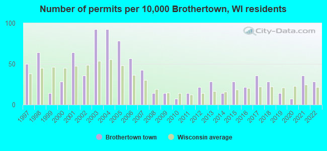
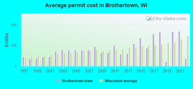
Single-family new house construction building permits:
- 2022: 4 buildings, average cost: $94,000
- 2021: 5 buildings, average cost: $424,900
- 2020: 1 building, cost: $420,000
- 2019: 2 buildings, average cost: $58,000
- 2018: 4 buildings, average cost: $416,300
- 2017: 5 buildings, average cost: $392,500
- 2016: 3 buildings, average cost: $219,400
- 2015: 4 buildings, average cost: $340,600
- 2014: 2 buildings, average cost: $273,000
- 2013: 4 buildings, average cost: $152,500
- 2012: 3 buildings, average cost: $148,300
- 2011: 2 buildings, average cost: $250,000
- 2010: 1 building, cost: $165,000
- 2009: 2 buildings, average cost: $165,000
- 2008: 2 buildings, average cost: $242,000
- 2007: 6 buildings, average cost: $197,400
- 2006: 8 buildings, average cost: $197,400
- 2005: 11 buildings, average cost: $197,400
- 2004: 13 buildings, average cost: $197,300
- 2003: 13 buildings, average cost: $197,800
- 2002: 5 buildings, average cost: $181,400
- 2001: 9 buildings, average cost: $113,500
- 2000: 4 buildings, average cost: $115,000
- 1999: 2 buildings, average cost: $96,500
- 1998: 9 buildings, average cost: $88,900
- 1997: 7 buildings, average cost: $114,300
| Here: | 2.1% |
| Wisconsin: | 2.7% |
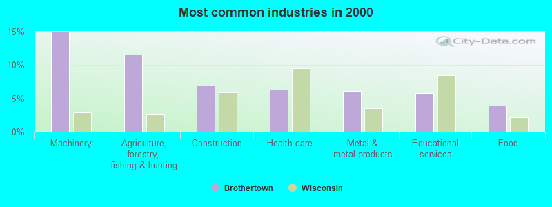
- Machinery (15.0%)
- Agriculture, forestry, fishing & hunting (11.5%)
- Construction (6.9%)
- Health care (6.3%)
- Metal & metal products (6.1%)
- Educational services (5.8%)
- Food (3.9%)
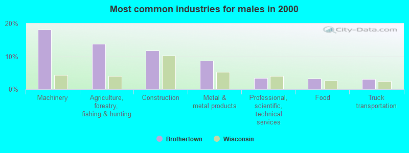
- Machinery (18.1%)
- Agriculture, forestry, fishing & hunting (13.7%)
- Construction (11.8%)
- Metal & metal products (8.7%)
- Professional, scientific, technical services (3.5%)
- Food (3.3%)
- Truck transportation (3.1%)
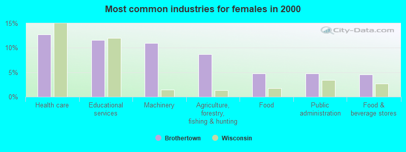
- Health care (12.7%)
- Educational services (11.5%)
- Machinery (11.0%)
- Agriculture, forestry, fishing & hunting (8.7%)
- Food (4.8%)
- Public administration (4.8%)
- Food & beverage stores (4.5%)
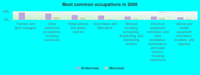
- Farmers and farm managers (9.1%)
- Other production occupations, including supervisors (7.9%)
- Metal workers and plastic workers (6.1%)
- Assemblers and fabricators (5.5%)
- Material recording, scheduling, dispatching, and distributing workers (4.2%)
- Electrical equipment mechanics and other installation, maintenance, and repair workers, including supervisors (4.2%)
- Vehicle and mobile equipment mechanics, installers, and repairers (3.3%)
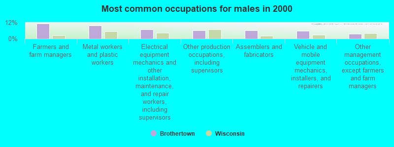
- Farmers and farm managers (11.1%)
- Metal workers and plastic workers (9.8%)
- Electrical equipment mechanics and other installation, maintenance, and repair workers, including supervisors (6.8%)
- Other production occupations, including supervisors (6.3%)
- Assemblers and fabricators (6.1%)
- Vehicle and mobile equipment mechanics, installers, and repairers (5.9%)
- Other management occupations, except farmers and farm managers (3.7%)
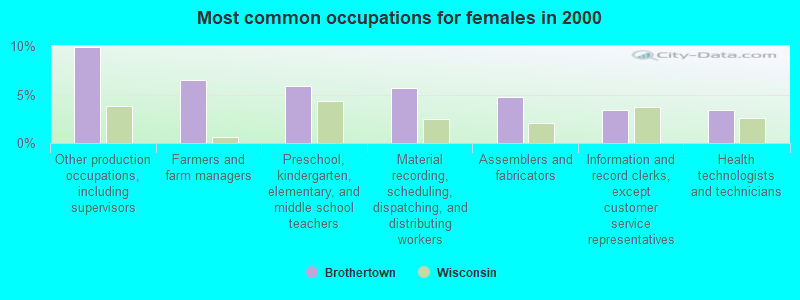
- Other production occupations, including supervisors (9.9%)
- Farmers and farm managers (6.5%)
- Preschool, kindergarten, elementary, and middle school teachers (5.9%)
- Material recording, scheduling, dispatching, and distributing workers (5.6%)
- Assemblers and fabricators (4.8%)
- Information and record clerks, except customer service representatives (3.4%)
- Health technologists and technicians (3.4%)
Average climate in Brothertown, Wisconsin
Based on data reported by over 4,000 weather stations


(lower is better)
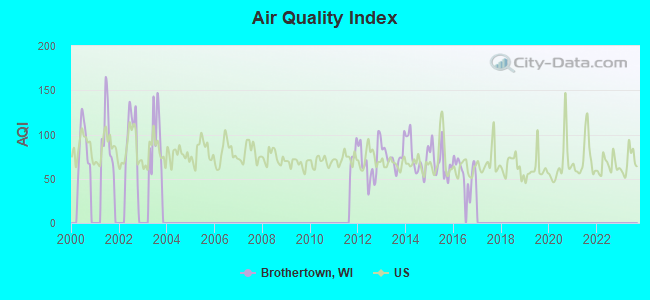
Air Quality Index (AQI) level in 2016 was 58.0. This is better than average.
| City: | 58.0 |
| U.S.: | 72.6 |
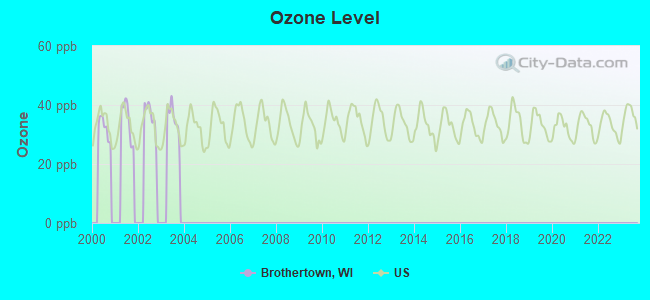
Ozone [ppb] level in 2003 was 35.8. This is about average. Closest monitor was 15.5 miles away from the city center.
| City: | 35.8 |
| U.S.: | 33.3 |
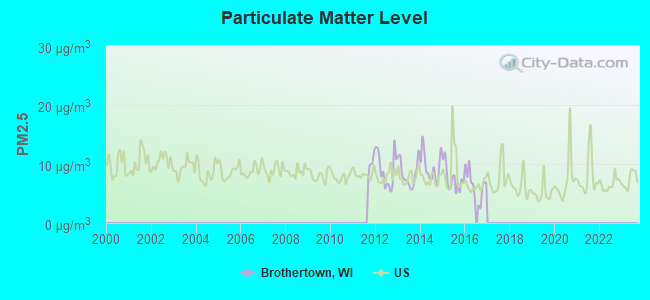
Particulate Matter (PM2.5) [µg/m3] level in 2016 was 6.47. This is better than average. Closest monitor was 15.5 miles away from the city center.
| City: | 6.47 |
| U.S.: | 8.11 |
Tornado activity:
Brothertown-area historical tornado activity is slightly above Wisconsin state average. It is 30% greater than the overall U.S. average.
On 7/18/1996, a category F5 (max. wind speeds 261-318 mph) tornado 18.7 miles away from the Brothertown town center injured 12 people and caused $40 million in damages.
On 4/21/1974, a category F4 (max. wind speeds 207-260 mph) tornado 15.4 miles away from the town center injured 35 people and caused between $500,000 and $5,000,000 in damages.
Earthquake activity:
Brothertown-area historical earthquake activity is significantly above Wisconsin state average. It is 8% smaller than the overall U.S. average.On 4/18/2008 at 09:36:59, a magnitude 5.4 (5.1 MB, 4.8 MS, 5.4 MW, 5.2 MW, Class: Moderate, Intensity: VI - VII) earthquake occurred 382.4 miles away from the city center
On 6/28/2004 at 06:10:52, a magnitude 4.2 (4.2 MW, Depth: 6.2 mi, Class: Light, Intensity: IV - V) earthquake occurred 177.0 miles away from Brothertown center
On 5/2/2015 at 16:23:07, a magnitude 4.2 (4.2 MW, Depth: 2.8 mi) earthquake occurred 186.5 miles away from the city center
On 6/10/1987 at 23:48:54, a magnitude 5.1 (4.9 MB, 4.4 MS, 4.6 MS, 5.1 LG) earthquake occurred 357.0 miles away from the city center
On 4/18/2008 at 09:36:59, a magnitude 5.2 (5.2 MW, Depth: 8.9 mi) earthquake occurred 382.5 miles away from Brothertown center
On 2/10/2010 at 09:59:35, a magnitude 3.8 (3.8 MW, Depth: 6.2 mi, Class: Light, Intensity: II - III) earthquake occurred 139.3 miles away from Brothertown center
Magnitude types: regional Lg-wave magnitude (LG), body-wave magnitude (MB), surface-wave magnitude (MS), moment magnitude (MW)
Natural disasters:
The number of natural disasters in Calumet County (10) is smaller than the US average (15).Major Disasters (Presidential) Declared: 8
Emergencies Declared: 2
Causes of natural disasters: Floods: 7, Storms: 6, Tornadoes: 4, Drought: 1, Hurricane: 1, Wind: 1, Other: 1 (Note: some incidents may be assigned to more than one category).

Hospitals and medical centers near Brothertown:
- CHILTON CARE CTR (Nursing Home, about 6 miles away; CHILTON, WI)
- CHILTON VILLAGE (Nursing Home, about 6 miles away; CHILTON, WI)
- CALUMET MEDICAL CTR Critical Access Hospitals (about 6 miles away; CHILTON, WI)
- CALUMET HOMESTEAD (Nursing Home, about 9 miles away; NEW HOLSTEIN, WI)
- HOMESTEAD CARE CENTER, LLC (Nursing Home, about 9 miles away; NEW HOLSTEIN, WI)
- WILLOWDALE NURSING AND REHAB (Nursing Home, about 9 miles away; NEW HOLSTEIN, WI)
- NORTHPOINT MED AND REHAB CTR (Nursing Home, about 15 miles away; OSHKOSH, WI)
Colleges/universities with over 2000 students nearest to Brothertown:
- University of Wisconsin-Oshkosh (about 16 miles; Oshkosh, WI; Full-time enrollment: 10,637)
- Moraine Park Technical College (about 16 miles; Fond du Lac, WI; FT enrollment: 3,079)
- Marian University (about 17 miles; Fond Du Lac, WI; FT enrollment: 2,045)
- Lakeland College (about 21 miles; Plymouth, WI; FT enrollment: 2,395)
- Lawrence University (about 22 miles; Appleton, WI; FT enrollment: 2,821)
- Fox Valley Technical College (about 24 miles; Appleton, WI; FT enrollment: 5,682)
- Saint Norbert College (about 34 miles; De Pere, WI; FT enrollment: 2,324)
Points of interest:
Notable location: Heritage Orchard (A). Display/hide its location on the map
Church in Brothertown: Holy Trinity Catholic Church (A). Display/hide its location on the map
Cemeteries: Dick Family Cemetery (1), Holy Trinity Catholic Cemetery (2), Morrill Family Cemetery (3), Union Cemetery (4), Rothmann Cemetery (5), Saint Charles Cemetery (6). Display/hide their locations on the map
| This town: | 2.5 people |
| Wisconsin: | 2.4 people |
| This town: | 73.4% |
| Whole state: | 64.4% |
| This town: | 6.7% |
| Whole state: | 7.3% |
Likely homosexual households (counted as self-reported same-sex unmarried-partner households)
- Lesbian couples: 0.2% of all households
- Gay men: 0.6% of all households
| This town: | 1.6% |
| Whole state: | 8.7% |
| This town: | 0.6% |
| Whole state: | 3.7% |
For population 15 years and over in Brothertown:
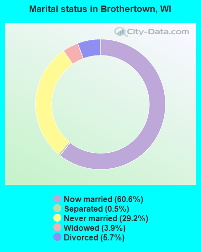
- Never married: 29.2%
- Now married: 60.6%
- Separated: 0.5%
- Widowed: 3.9%
- Divorced: 5.7%
For population 25 years and over in Brothertown:
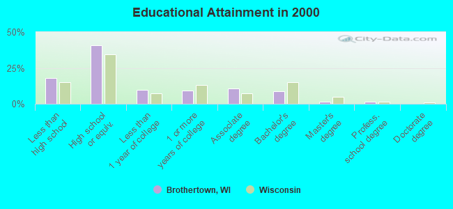
- High school or higher: 81.9%
- Bachelor's degree or higher: 11.7%
- Graduate or professional degree: 3.0%
- Unemployed: 2.9%
- Mean travel time to work (commute): 24.4 minutes
| Here: | 10.6 |
| Wisconsin average: | 11.0 |
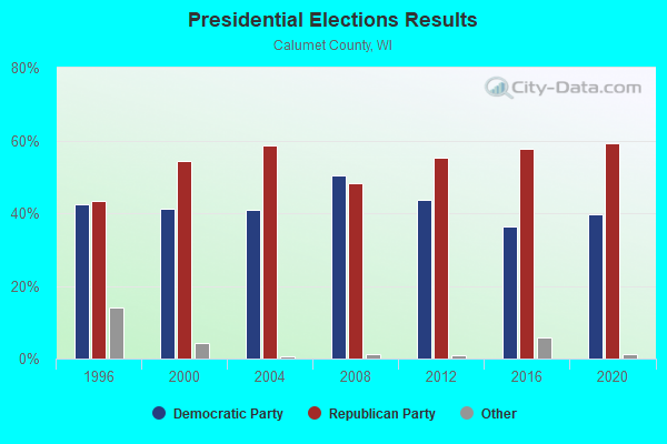
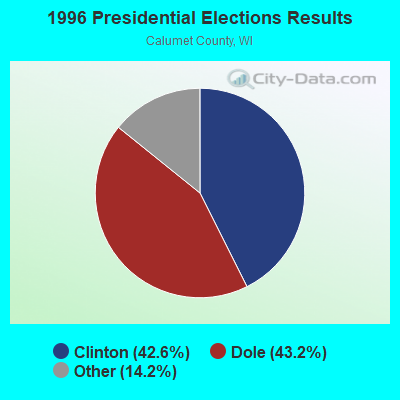
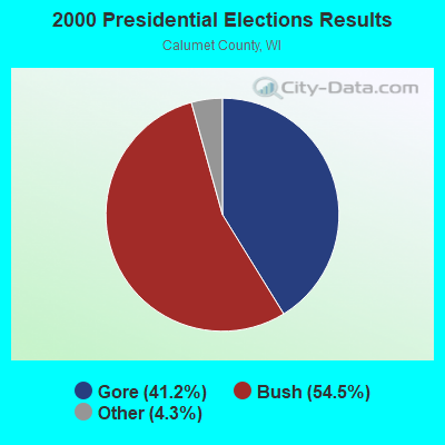
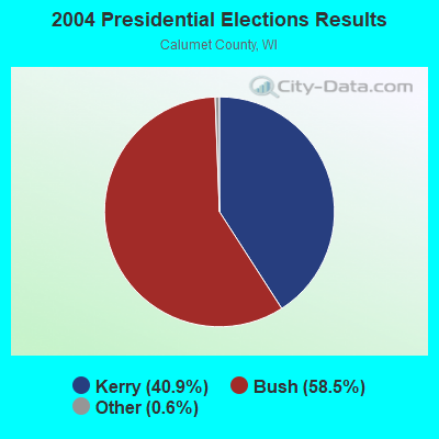
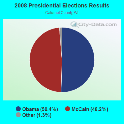
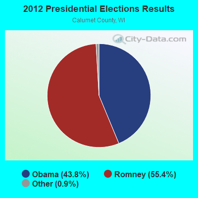
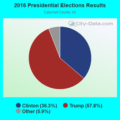
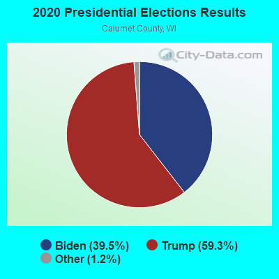
Graphs represent county-level data. Detailed 2008 Election Results
Religion statistics for Brothertown, WI (based on Calumet County data)
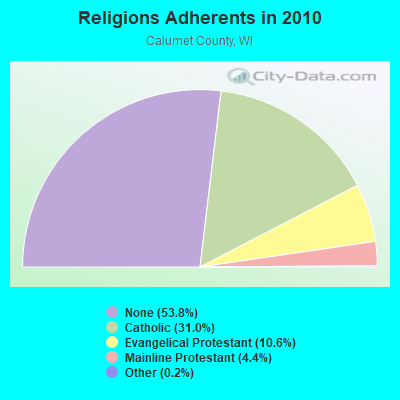
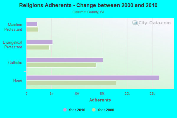
| Religion | Adherents | Congregations |
|---|---|---|
| Catholic | 15,168 | 7 |
| Evangelical Protestant | 5,208 | 15 |
| Mainline Protestant | 2,145 | 8 |
| Other | 83 | 1 |
| None | 26,367 | - |
Food Environment Statistics:
| Here: | 1.36 / 10,000 pop. |
| Wisconsin: | 1.86 / 10,000 pop. |
| Calumet County: | 0.23 / 10,000 pop. |
| State: | 0.11 / 10,000 pop. |
| Calumet County: | 3.62 / 10,000 pop. |
| State: | 4.12 / 10,000 pop. |
| Here: | 6.33 / 10,000 pop. |
| Wisconsin: | 8.64 / 10,000 pop. |
| This county: | 6.7% |
| State: | 7.6% |
| Calumet County: | 27.2% |
| Wisconsin: | 27.5% |
| This county: | 14.7% |
| Wisconsin: | 13.0% |
Strongest AM radio stations in Brothertown:
- WNAM (1280 AM; 50 kW; NEENAH-MENASHA, WI; Owner: CUMULUS LICENSING CORP.)
- WHBY (1150 AM; 25 kW; KIMBERLY, WI; Owner: WOODWARD COMMUNICATIONS, INC.)
- WTMJ (620 AM; 50 kW; MILWAUKEE, WI; Owner: JOURNAL BROADCAST CORPORATION)
- WSPT (1010 AM; 50 kW; STEVENS POINT, WI)
- WTAQ (1360 AM; 10 kW; GREEN BAY, WI; Owner: MIDWEST COMMUNICATIONS, INC.)
- WCUB (980 AM; 5 kW; TWO RIVERS, WI; Owner: CUB RADIO, INC.)
- WISN (1130 AM; 50 kW; MILWAUKEE, WI; Owner: CAPSTAR TX LIMITED PARTNERSHIP)
- WMBE (1530 AM; daytime; 0 kW; CHILTON, WI; Owner: MASZJA-PACER RADIO, INC.)
- WSAU (550 AM; 20 kW; WAUSAU, WI; Owner: WRIG, INC.)
- WHBL (1330 AM; 5 kW; SHEBOYGAN, WI; Owner: MIDWEST COMMUNICATIONS, INC.)
- WGN (720 AM; 50 kW; CHICAGO, IL; Owner: WGN CONTINENTAL BROADCASTING CO.)
- WSCR (670 AM; 50 kW; CHICAGO, IL; Owner: INFINITY BROADCASTING OPERATIONS, INC.)
- WBBM (780 AM; 50 kW; CHICAGO, IL; Owner: INFINITY BROADCASTING OPERATIONS, INC.)
Strongest FM radio stations in Brothertown:
- WAPL-FM (105.7 FM; APPLETON, WI; Owner: WOODWARD COMMUNICATIONS, INC.)
- WROE (94.3 FM; NEENAH-MENASHA, WI; Owner: MIDWEST COMMUNICATIONS, INC.)
- KFIZ-FM (107.1 FM; FOND DU LAC, WI; Owner: RBH ENTERPRISES, INC.)
- WHID (88.1 FM; GREEN BAY, WI; Owner: BD OF REGENTS OF THE UNIV OF WI SYS)
- WIXX (101.1 FM; GREEN BAY, WI; Owner: MIDWEST COMMUNICATIONS, INC.)
- WVBO (103.9 FM; WINNECONNE, WI; Owner: CUMULUS LICENSING CORP.)
- WOGB (103.1 FM; KAUKAUNA, WI; Owner: CUMULUS LICENSING CORP.)
- WPCK (104.9 FM; KAUKAUNA, WI; Owner: MIDWEST DIMENSIONS, INC.)
- WXWX (107.5 FM; BRILLION, WI; Owner: CUMULUS LICENSING CORP.)
- WPNE-FM (89.3 FM; GREEN BAY, WI; Owner: WISCONSIN EDUCATIONAL COMMUNICATIONS BOARD)
- WSTM (91.3 FM; KIEL, WI; Owner: JUBILATION MINISTRIES INC)
- WNCY-FM (100.3 FM; NEENAH-MENASHA, WI; Owner: MIDWEST COMMUNICATIONS, INC.)
- WKSZ (95.9 FM; DE PERE, WI; Owner: WOODWARD COMMUNICATIONS INC)
- WWWX (96.9 FM; OSHKOSH, WI; Owner: CUMULUS LICENSING CORP.)
- WORQ (90.1 FM; GREEN BAY, WI; Owner: LAKESHORE COMMUNICATIONS, INC.)
- W203AV (88.5 FM; OSHKOSH, WI; Owner: WRVM, INC.)
- WLFM (91.1 FM; APPLETON, WI; Owner: LAWRENCE UNIVERSITY OF WISCONSIN)
- WXER (104.5 FM; PLYMOUTH, WI; Owner: RBH ENTERPRISES, INC. D/B/A YELLOW DOG BROADCASTING)
- WEMI (91.9 FM; APPLETON, WI; Owner: EVANGEL MINISTRIES, INC.)
- WTCX (96.1 FM; RIPON, WI; Owner: RADIO B/C LTD PARTNERSHIP)
TV broadcast stations around Brothertown:
- WMMF-TV (Channel 68; FOND DU LAC, WI; Owner: PAPPAS TELECASTING OF WISCONSIN, A CALIFORNIA LTD PARTNRSHP)
- WLUK-TV (Channel 11; GREEN BAY, WI; Owner: EMMIS TELEVISION LICENSE CORPORATION)
- WFRV-TV (Channel 5; GREEN BAY, WI; Owner: CBS BROADCASTING INC.)
- WBAY-TV (Channel 2; GREEN BAY, WI; Owner: YOUNG BROADCASTING OF GREEN BAY, INC.)
- WGBA (Channel 26; GREEN BAY, WI; Owner: ARIES TELECOMMUNICATION CORPORATION)
- W23BL (Channel 23; TRAVERSE CITY, MI; Owner: MS COMMUNICATIONS, LLC)
- WPNE (Channel 38; GREEN BAY, WI; Owner: WISCONSIN EDUCATIONAL COMMUNICATIONS BOARD)
- WACY (Channel 32; APPLETON, WI; Owner: ACE TV, INC.)
- WWRS-TV (Channel 52; MAYVILLE, WI; Owner: NATIONAL MINORITY T.V., INC.)
- W17CF (Channel 17; RIPON, WI; Owner: TRINITY BROADCASTING NETWORK)
- W49CB (Channel 49; GREEN BAY, WI; Owner: TRINITY BROADCASTING NETWORK)
- W30BU (Channel 30; GREEN BAY, WI; Owner: THREE ANGELS BROADCASTING NETWORK)
- National Bridge Inventory (NBI) Statistics
- 10Number of bridges
- 39ft / 11.9mTotal length
- $181,000Total costs
- 2,136Total average daily traffic
- 2,347Total future (year 2039) average daily traffic
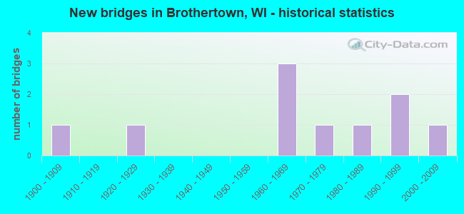
- New bridges - historical statistics
- 11900-1909
- 11920-1929
- 31960-1969
- 11970-1979
- 11980-1989
- 21990-1999
- 12000-2009
FCC Registered Antenna Towers:
15 (See the full list of FCC Registered Antenna Towers in Brothertown)FCC Registered Microwave Towers:
5- Brothertown, Lat: 43.985694 Lon: -88.298083, Type: Tower, Structure height: 76.2 m, Overall height: 79.2 m, Call Sign: WQIB703,
Assigned Frequencies: 3650.00 MHz, Grant Date: 01/09/2018, Expiration Date: 02/14/2021, Cancellation Date: 03/09/2021, Certifier: Jacob E Brown, Registrant: Herman & Whiteaker, LLC, 6720-B Rockledge Drive, Suite 150, Bethesda, MD 20817, Phone: (202) 600-7274, Fax: (202) 706-6056, Email:
- BROTHERTOWN, 0.52 Mi W Of Highway 151 (Lat: 43.985694 Lon: -88.298083), Type: Gtower, Structure height: 76.2 m, Overall height: 79.2 m, Call Sign: WQMG843,
Assigned Frequencies: 10755.0 MHz, Grant Date: 06/30/2020, Expiration Date: 08/04/2030, Certifier: John E Rooney, Registrant: Wilkinson Barker Knauer, LLP, 1800 M Street Nw, Suite 800n, Washington, DC 20036, Phone: (202) 383-3420, Fax: (202) 783-5851, Email:
- ML15AL163, 0.52 Mi W Of Highway 151 (Lat: 43.985694 Lon: -88.298083), Type: Ltower, Structure height: 76.2 m, Overall height: 79.2 m, Call Sign: WQRF385,
Assigned Frequencies: 10915.0 MHz, Grant Date: 07/06/2023, Expiration Date: 05/01/2033, Certifier: David Werblow, Registrant: T-Mobile Usa, Inc., 12920 Se 38th St, Bellevue, WA 98006, Phone: (425) 383-8401, Fax: (425) 383-4840, Email:
- BROTHERTOWN, 0.52 Mi W Of Highway 151 (Lat: 43.985694 Lon: -88.298083), Type: Gtower, Structure height: 76.2 m, Overall height: 79.2 m, Call Sign: WQYD885,
Assigned Frequencies: 10995.0 MHz, 11075.0 MHz, 10995.0 MHz, 11075.0 MHz, 10995.0 MHz, 11075.0 MHz, 10995.0 MHz, 11075.0 MHz, 10995.0 MHz, 11075.0 MHz, Grant Date: 08/27/2016, Expiration Date: 08/27/2026, Certifier: Dean Hanson, Registrant: Intelpath, Hinsdale, IL 60522, Phone: (312) 841-9188, Email:
- ML84236A, 0.52 Mi W Of Highway 151 (Lat: 43.985694 Lon: -88.298083), Type: Ltower, Structure height: 76.2 m, Overall height: 79.2 m, Call Sign: WRUU342,
Assigned Frequencies: 11155.0 MHz, 11155.0 MHz, 11155.0 MHz, 11155.0 MHz, 11155.0 MHz, 11155.0 MHz, 11155.0 MHz, 11155.0 MHz, 11155.0 MHz, 11155.0 MHz... (+5 more), Grant Date: 10/04/2022, Expiration Date: 10/04/2032, Certifier: Jenny Knopf, Registrant: T-Mobile Usa, Inc., 12920 Se 38th Street, Bellevue, WA 98006, Phone: (425) 383-8401, Fax: (425) 383-4040, Email:
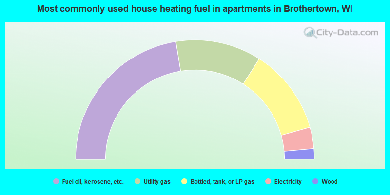
- 39.7%Fuel oil, kerosene, etc.
- 28.9%Utility gas
- 22.7%Bottled, tank, or LP gas
- 5.5%Wood
- 2.2%Electricity
- 0.9%Other fuel
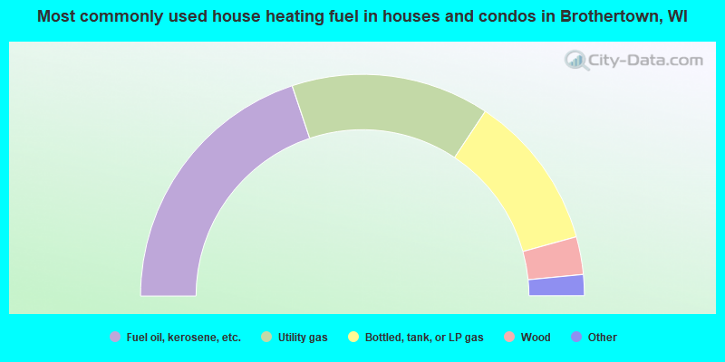
- 44.9%Fuel oil, kerosene, etc.
- 23.2%Utility gas
- 23.2%Bottled, tank, or LP gas
- 5.8%Electricity
- 2.9%Wood
Brothertown compared to Wisconsin state average:
- Unemployed percentage significantly below state average.
- Black race population percentage significantly below state average.
- Hispanic race population percentage significantly below state average.
- Foreign-born population percentage significantly below state average.
- Renting percentage significantly below state average.
- Length of stay since moving in significantly above state average.
- Number of rooms per house significantly below state average.
- House age significantly below state average.
- Percentage of population with a bachelor's degree or higher below state average.