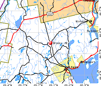
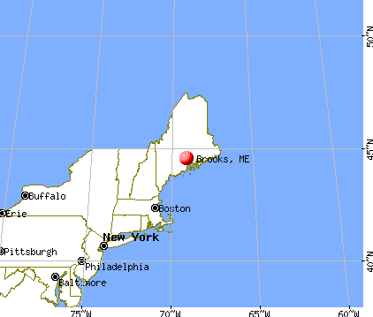
Brooks, Maine
Submit your own pictures of this town and show them to the world
- OSM Map
- General Map
- Google Map
- MSN Map
Population change since 2000: +5.5%
 |
| Males: 554 | |
| Females: 524 |
| Median resident age: | 40.2 years |
| Maine median age: | 43.0 years |
Zip codes: 04921.
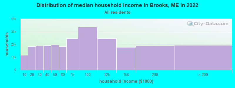
| Brooks: | $56,584 |
| ME: | $69,543 |
Estimated per capita income in 2022: $30,649 (it was $14,446 in 2000)
Brooks town income, earnings, and wages data
Estimated median house or condo value in 2022: $226,637 (it was $77,600 in 2000)
| Brooks: | $226,637 |
| ME: | $290,600 |
Mean prices in 2022: all housing units: $270,070; detached houses: $293,055; townhouses or other attached units: $325,130; in 2-unit structures: $297,158; in 3-to-4-unit structures: $211,194; in 5-or-more-unit structures: $284,526; mobile homes: $128,233; occupied boats, rvs, vans, etc.: $21,180
Detailed information about poverty and poor residents in Brooks, ME


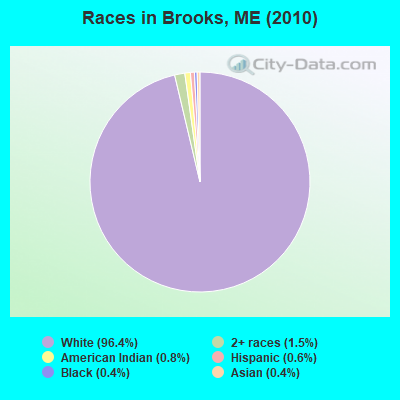
- 1,03996.4%White alone
- 161.5%Two or more races
- 90.8%American Indian alone
- 60.6%Hispanic
- 40.4%Black alone
- 40.4%Asian alone
Races in Brooks detailed stats: ancestries, foreign born residents, place of birth
According to our research of Maine and other state lists, there were 5 registered sex offenders living in Brooks, Maine as of May 08, 2024.
The ratio of all residents to sex offenders in Brooks is 216 to 1.
 Recent articles from our blog. Our writers, many of them Ph.D. graduates or candidates, create easy-to-read articles on a wide variety of topics.

 | Maine standards-what is a "pond" vs. what is a "lake?" (59 replies) |
| On Ice (33 replies) |
| Good industrys to be in if i would like to live in rural maine? (81 replies) |
| Questions for Transplants with Families - where are the kids? (11 replies) |
| Artist in Brooks, Maine (2 replies) |
| Searsport Opinions/Experience (10 replies) |
Latest news from Brooks, ME collected exclusively by city-data.com from local newspapers, TV, and radio stations
Brooks, ME City Guides:
Ancestries: English (21.7%), United States (9.7%), French (9.1%), Irish (9.0%), Italian (6.3%), German (5.4%).
Current Local Time: EST time zone
Incorporated on 12/10/1816
Elevation: 387 feet
Land area: 24.4 square miles.
Population density: 44 people per square mile (very low).
19 residents are foreign born
| This town: | 1.9% |
| Maine: | 2.9% |
| Brooks town: | 1.0% ($779) |
| Maine: | 1.5% ($1,417) |
Nearest city with pop. 50,000+: Portland, ME  (83.0 miles , pop. 64,249).
Nearest city with pop. 200,000+: Boston, MA (182.3 miles , pop. 589,141).
Nearest city with pop. 1,000,000+: Bronx, NY (351.3 miles , pop. 1,332,650).
Nearest cities:
), ), ), ), ), Latitude: 44.54 N, Longitude: 69.12 W
Area code: 207

| Here: | 3.1% |
| Maine: | 3.4% |


- Construction (10.5%)
- Health care (9.2%)
- Educational services (8.4%)
- Agriculture, forestry, fishing & hunting (7.8%)
- Finance & insurance (5.5%)
- Building material & garden equipment & supplies dealers (4.7%)
- Public administration (4.5%)
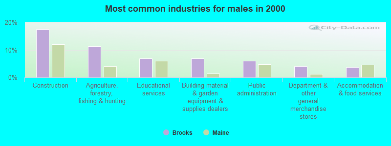
- Construction (17.5%)
- Agriculture, forestry, fishing & hunting (11.4%)
- Educational services (6.9%)
- Building material & garden equipment & supplies dealers (6.9%)
- Public administration (6.1%)
- Department & other general merchandise stores (4.1%)
- Accommodation & food services (3.7%)

- Health care (17.0%)
- Educational services (10.0%)
- Finance & insurance (7.5%)
- Private households (5.0%)
- Food (5.0%)
- Agriculture, forestry, fishing & hunting (4.1%)
- Department & other general merchandise stores (4.1%)

- Other sales and related occupations, including supervisors (7.0%)
- Other production occupations, including supervisors (6.2%)
- Carpenters (4.1%)
- Material recording, scheduling, dispatching, and distributing workers (3.5%)
- Driver/sales workers and truck drivers (3.5%)
- Nursing, psychiatric, and home health aides (3.1%)
- Farmers and farm managers (2.9%)

- Other production occupations, including supervisors (8.5%)
- Carpenters (8.1%)
- Other sales and related occupations, including supervisors (7.7%)
- Driver/sales workers and truck drivers (6.5%)
- Farmers and farm managers (4.9%)
- Vehicle and mobile equipment mechanics, installers, and repairers (4.9%)
- Other management occupations, except farmers and farm managers (4.5%)

- Nursing, psychiatric, and home health aides (6.2%)
- Other sales and related occupations, including supervisors (6.2%)
- Cashiers (5.4%)
- Supervisors and other personal care and service workers, except child care workers (5.0%)
- Secretaries and administrative assistants (4.6%)
- Material recording, scheduling, dispatching, and distributing workers (4.1%)
- Preschool, kindergarten, elementary, and middle school teachers (3.7%)
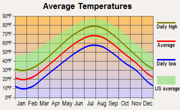
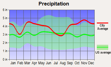
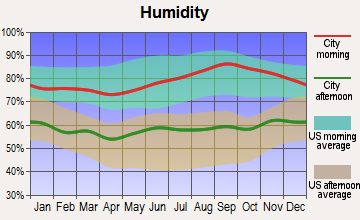
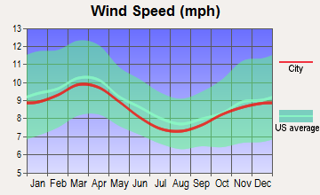
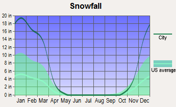
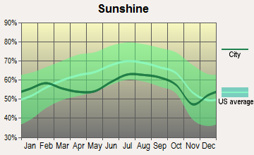
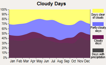
Average climate in Brooks, Maine
Based on data reported by over 4,000 weather stations

Earthquake activity:
Brooks-area historical earthquake activity is significantly above Maine state average. It is 79% smaller than the overall U.S. average.On 10/16/2012 at 23:12:25, a magnitude 4.7 (4.7 ML, Depth: 10.0 mi, Class: Light, Intensity: IV - V) earthquake occurred 100.2 miles away from the city center
On 4/20/2002 at 10:50:47, a magnitude 5.3 (5.3 ML, Depth: 3.0 mi, Class: Moderate, Intensity: VI - VII) earthquake occurred 225.5 miles away from Brooks center
On 4/20/2002 at 10:50:47, a magnitude 5.2 (5.2 MB, 4.2 MS, 5.2 MW, 5.0 MW) earthquake occurred 226.6 miles away from Brooks center
On 1/19/1982 at 00:14:42, a magnitude 4.7 (4.5 MB, 4.7 MD, 4.5 LG) earthquake occurred 142.5 miles away from Brooks center
On 10/7/1983 at 10:18:46, a magnitude 5.3 (5.1 MB, 5.3 LG, 5.1 ML) earthquake occurred 261.6 miles away from the city center
On 2/26/1999 at 03:38:43, a magnitude 3.8 (3.8 LG, Depth: 2.0 mi, Class: Light, Intensity: II - III) earthquake occurred 19.9 miles away from the city center
Magnitude types: regional Lg-wave magnitude (LG), body-wave magnitude (MB), duration magnitude (MD), local magnitude (ML), surface-wave magnitude (MS), moment magnitude (MW)
Natural disasters:
The number of natural disasters in Waldo County (19) is greater than the US average (15).Major Disasters (Presidential) Declared: 15
Emergencies Declared: 3
Causes of natural disasters: Floods: 14, Storms: 11, Snows: 3, Heavy Rains: 2, Winter Storms: 2, Blizzard: 1, Hurricane: 1, Ice Storm: 1, Landslide: 1, Snowfall: 1, Wind: 1, Other: 1 (Note: some incidents may be assigned to more than one category).
Hospitals and medical centers near Brooks:
- HARBOR HILL CENTER (Nursing Home, about 10 miles away; BELFAST, ME)
- BRADBURY MANOR (Nursing Home, about 11 miles away; BELFAST, ME)
- THE COMMONS AT TALL PINES (Nursing Home, about 11 miles away; BELFAST, ME)
- DIALYSIS CLINIC INC. - BELFAST (Dialysis Facility, about 12 miles away; BELFAST, ME)
- WALDO COUNTY GENERAL HOSPITAL Critical Access Hospitals (about 12 miles away; BELFAST, ME)
Colleges/universities with over 2000 students nearest to Brooks:
- Husson University (about 26 miles; Bangor, ME; Full-time enrollment: 2,421)
- University of Maine (about 34 miles; Orono, ME; FT enrollment: 8,931)
- University of Maine at Augusta (about 36 miles; Augusta, ME; FT enrollment: 3,204)
- University of Maine at Farmington (about 52 miles; Farmington, ME; FT enrollment: 2,036)
- Southern Maine Community College (about 83 miles; South Portland, ME; FT enrollment: 4,666)
- University of Southern Maine (about 84 miles; Portland, ME; FT enrollment: 6,647)
- Saint Joseph's College of Maine (about 84 miles; Standish, ME; FT enrollment: 2,010)
Public elementary/middle school in Brooks:
- MORSE MEMORIAL SCHOOL (Location: NO PHYSICAL LOCATION AVAILABLE, Grades: PK-5)
Points of interest:
Notable locations in Brooks: Camp Fair Haven (A), Camp Paysock (B), Arthur Jewell Community Health Center Ambulance Service (C), Brooks Volunteer Fire Department (D). Display/hide their locations on the map
Cemetery: Reynolds Cemetery (1). Display/hide its location on the map
Lakes and reservoirs: Dutton Pond (A), Halfmoon Pond (B), Lake Passagassawakeag (C), Ellis Pond (D), Sanborn Pond (E). Display/hide their locations on the map
Streams, rivers, and creeks: Stantial Brook (A), Hussey Brook (B), Meadow Brook (C). Display/hide their locations on the map
Drinking water stations with addresses in Brooks and their reported violations in the past:
FAIR HAVEN CAMPS (Population served: 277, Groundwater):Past health violations:
- MCL, Monthly (TCR) - In DEC-2009, Contaminant: Coliform. Follow-up actions: St Public Notif requested (DEC-31-2009), St Formal NOV issued (DEC-31-2009), St AO (w/o penalty) issued (APR-07-2010), St Public Notif received (MAY-24-2010), St Compliance Meeting conducted (JUN-07-2010), St Compliance achieved (JUN-07-2010)
- MCL, Monthly (TCR) - In OCT-2009, Contaminant: Coliform. Follow-up actions: St Public Notif requested (NOV-04-2009), St Formal NOV issued (NOV-04-2009), St AO (w/o penalty) issued (APR-07-2010), St Public Notif received (MAY-24-2010), St Compliance Meeting conducted (JUN-07-2010), St Compliance achieved (JUN-07-2010)
- MCL, Monthly (TCR) - In SEP-2009, Contaminant: Coliform. Follow-up actions: St Formal NOV issued (SEP-18-2009), St Public Notif requested (SEP-18-2009), St Public Notif received (SEP-29-2009), St AO (w/o penalty) issued (APR-07-2010), St Compliance achieved (JUN-07-2010), St Compliance Meeting conducted (JUN-07-2010)
- MCL, Monthly (TCR) - In AUG-2009, Contaminant: Coliform. Follow-up actions: St Formal NOV issued (SEP-10-2009), St Public Notif requested (SEP-10-2009), St Public Notif received (SEP-21-2009), St AO (w/o penalty) issued (APR-07-2010), St Compliance achieved (JUN-07-2010), St Compliance Meeting conducted (JUN-07-2010)
| This town: | 2.4 people |
| Maine: | 2.3 people |
| This town: | 63.9% |
| Whole state: | 62.9% |
| This town: | 9.9% |
| Whole state: | 9.4% |
Likely homosexual households (counted as self-reported same-sex unmarried-partner households)
- Lesbian couples: 0.9% of all households
- Gay men: 0.4% of all households
| This town: | 19.5% |
| Whole state: | 10.9% |
| This town: | 9.3% |
| Whole state: | 4.1% |
For population 15 years and over in Brooks:
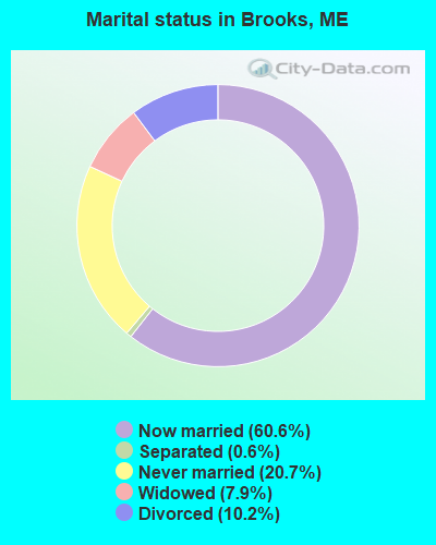
- Never married: 20.7%
- Now married: 60.6%
- Separated: 0.6%
- Widowed: 7.9%
- Divorced: 10.2%
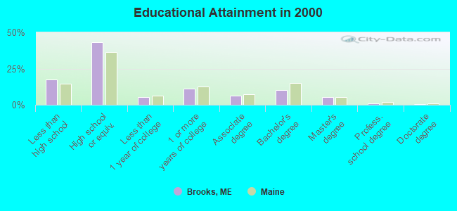
For population 25 years and over in Brooks:
- High school or higher: 82.7%
- Bachelor's degree or higher: 16.9%
- Graduate or professional degree: 6.7%
- Unemployed: 8.5%
- Mean travel time to work (commute): 25.1 minutes
| Here: | 10.4 |
| Maine average: | 11.2 |

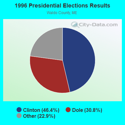
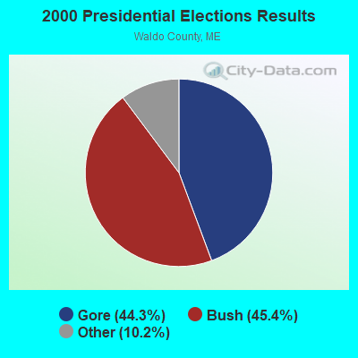


Graphs represent county-level data. Detailed 2008 Election Results
Religion statistics for Brooks, ME (based on Waldo County data)
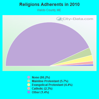
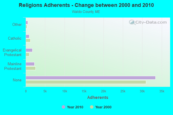
| Religion | Adherents | Congregations |
|---|---|---|
| Mainline Protestant | 2,204 | 20 |
| Evangelical Protestant | 1,711 | 23 |
| Catholic | 900 | 3 |
| Other | 554 | 7 |
| None | 33,417 | - |
Food Environment Statistics:
| Here: | 2.60 / 10,000 pop. |
| State: | 2.80 / 10,000 pop. |
| Waldo County: | 1.82 / 10,000 pop. |
| Maine: | 2.20 / 10,000 pop. |
| This county: | 7.02 / 10,000 pop. |
| State: | 5.75 / 10,000 pop. |
| Waldo County: | 8.84 / 10,000 pop. |
| Maine: | 11.02 / 10,000 pop. |
| Waldo County: | 9.2% |
| Maine: | 8.2% |
| This county: | 26.1% |
| State: | 25.0% |
Businesses in Brooks, ME
- U-Haul: 1
Strongest AM radio stations in Brooks:
- WZON (620 AM; 5 kW; BANGOR, ME; Owner: THE ZONE CORPORATION)
- WSKW (1160 AM; 10 kW; SKOWHEGAN, ME; Owner: MOUNTAIN WIRELESS, INCORPORATED)
- WABI (910 AM; 5 kW; BANGOR, ME; Owner: CLEAR CHANNEL BROADCASTING LICENSES, INC.)
- WDEA (1370 AM; 5 kW; ELLSWORTH, ME; Owner: CUMULUS LICENSING CORP.)
- WTME (780 AM; 10 kW; RUMFORD, ME; Owner: MOUNTAIN VALLEY BROADCASTING, INC.)
- WFAU (1280 AM; 5 kW; GARDINER, ME; Owner: CAPSTAR TX LIMITED PARTNERSHIP)
- WRKO (680 AM; 50 kW; BOSTON, MA; Owner: ENTERCOM BOSTON LICENSE, LLC)
- WEEI (850 AM; 50 kW; BOSTON, MA; Owner: ENTERCOM BOSTON LICENSE, LLC)
- WBZ (1030 AM; 50 kW; BOSTON, MA; Owner: INFINITY BROADCASTING OPERATIONS, INC.)
- WMTW (870 AM; 10 kW; GORHAM, ME; Owner: RADIO PARTNERS OF MAINE, L.P.)
- WCRN (830 AM; 50 kW; WORCESTER, MA; Owner: CARTER BROADCASTING CORPORATION)
- WNNZ (640 AM; 50 kW; WESTFIELD, MA; Owner: CLEAR CHANNEL BROADCASTING LICENSES, INC.)
- WGAN (560 AM; 5 kW; PORTLAND, ME; Owner: SAGA COMMUNICATIONS OF NEW ENGLAND, LLC)
Strongest FM radio stations in Brooks:
- WWBX (97.1 FM; BANGOR, ME; Owner: CLEAR CHANNEL BROADCASTING LICENSES, INC.)
- WBFB (104.7 FM; BELFAST, ME; Owner: CLEAR CHANNEL BROADCASTING LICENSES, INC.)
- WFZX (101.7 FM; SEARSPORT, ME; Owner: CLEAR CHANNEL BROADCASTING LICENSES, INC.)
- WMEP (90.5 FM; CAMDEN, ME; Owner: MAINE PUBLIC BROADCASTING CORP.)
- WQSS (102.5 FM; CAMDEN, ME; Owner: CLEAR CHANNEL BROADCASTING LICENSES, INC.)
- WKIT-FM (100.3 FM; BREWER, ME; Owner: THE ZONE CORPORATION)
- WWMJ (95.7 FM; ELLSWORTH, ME; Owner: CUMULUS LICENSING CORP.)
- WERU-FM (89.9 FM; BLUE HILL, ME; Owner: SALT POND COMMUNITY B/C COMPANY)
- WQCB (106.5 FM; BREWER, ME; Owner: CUMULUS LICENSING CORP.)
- WTOS-FM (105.1 FM; SKOWHEGAN, ME; Owner: CAPSTAR TX LIMITED PARTNERSHIP)
- WMCM (103.3 FM; ROCKLAND, ME; Owner: CLEAR CHANNEL BROADCASTING LICENSES, INC.)
- WWWA (95.3 FM; WINSLOW, ME; Owner: LIGHT OF LIFE MINISTRIES, INC.)
- WMEH (90.9 FM; BANGOR, ME; Owner: MAINE PUBLIC BROADCASTING CORPORATION)
- WEZQ (92.9 FM; BANGOR, ME; Owner: CUMULUS LICENSING CORP.)
- WVOM (103.9 FM; HOWLAND, ME; Owner: CLEAR CHANNEL BROADCASTING LICENSES, INC.)
- WHCF (88.5 FM; BANGOR, ME; Owner: BANGOR BAPTIST CHURCH)
- WCTB (93.5 FM; FAIRFIELD, ME; Owner: MOUNTAIN WIRELESS, INC.)
- WBQX (106.9 FM; THOMASTON, ME; Owner: MARINER BROADCASTING LIMITED PARTNER)
- WBYA (105.5 FM; ISLESBORO, ME; Owner: MARINER BROADCASTING LIMTED PARTNERSHIP)
- WHQO (107.9 FM; SKOWHEGAN, ME; Owner: MOUNTAIN WIRELESS, INC.)
TV broadcast stations around Brooks:
- WABI-TV (Channel 5; BANGOR, ME; Owner: COMMUNITY BROADCASTING SERVICE)
- W36CK (Channel 36; BANGOR, ME; Owner: TRINITY BROADCASTING NETWORK)
- WCKD-LP (Channel 30; BANGOR/DEDHAM, ME; Owner: J. MCLEOD, ME FAMILY B/CING., INC.)
Brooks fatal accident list:
Oct 9, 2002 05:06 PM, Valley Road, Vehicles: 1, Persons: 1, Fatalities: 1
Jun 21, 1988 05:20 PM, 1522, Vehicles: 2, Persons: 2, Fatalities: 1
May 15, 1986 04:15 PM, 15201522, Vehicles: 2, Persons: 2, Fatalities: 1
- National Bridge Inventory (NBI) Statistics
- 4Number of bridges
- 13ft / 3.6mTotal length
- 5,388Total average daily traffic
- 268Total average daily truck traffic
- 7,954Total future (year 2036) average daily traffic
FCC Registered Antenna Towers:
8 (See the full list of FCC Registered Antenna Towers in Brooks)FCC Registered Microwave Towers:
2- BROOKS_USF, Reynolds Road (Lat: 44.538972 Lon: -69.126389), Type: Tower, Structure height: 76.2 m, Overall height: 78 m, Call Sign: WQOE880,
Assigned Frequencies: 6063.80 MHz, Grant Date: 08/03/2021, Expiration Date: 09/06/2031, Certifier: Steven T Campbell, Registrant: Wilkinson Barker Knauer, LLP, 1800 M Street Nw, Suite 800n, Washington, DC 20036, Phone: (202) 383-3420, Fax: (202) 783-5851, Email:
- Brooks, 276 Veterans Highway (Lat: 44.535556 Lon: -69.109583), Type: Ltower, Structure height: 57.9 m, Call Sign: WQSY602,
Assigned Frequencies: 10895.0 MHz, 10895.0 MHz, 10895.0 MHz, 10895.0 MHz, 10895.0 MHz, 10895.0 MHz, 10895.0 MHz, 10895.0 MHz, 10895.0 MHz, 10815.0 MHz... (+8 more), Grant Date: 12/10/2013, Expiration Date: 12/10/2023, Cancellation Date: 09/17/2020, Certifier: Jessica B Lyons, Registrant: At&t Services, Inc., 208 S Akard St, Rm 2100, Dallas, TX 75202, Phone: (855) 699-7073, Email:
FCC Registered Amateur Radio Licenses:
10 (See the full list of FCC Registered Amateur Radio Licenses in Brooks)2004 - 2018 National Fire Incident Reporting System (NFIRS) incidents
- Fire incident types reported to NFIRS in Brooks, ME
- 11171.6%Structure Fires
- 2616.8%Outside Fires
- 1811.6%Mobile Property/Vehicle Fires
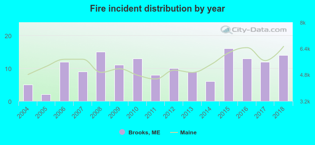 According to the data from the years 2004 - 2018 the average number of fire incidents per year is 10. The highest number of fires - 16 took place in 2015, and the least - 2 in 2005. The data has an increasing trend.
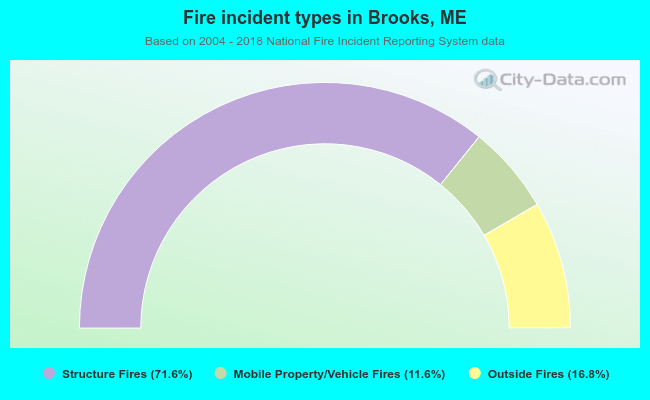 When looking into fire subcategories, the most incidents belonged to: Structure Fires (71.6%), and Outside Fires (16.8%).
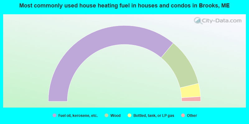
- 72.2%Fuel oil, kerosene, etc.
- 20.3%Wood
- 5.6%Bottled, tank, or LP gas
- 1.3%Electricity
- 0.7%Coal or coke
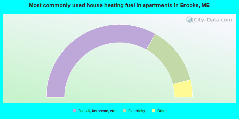
- 66.3%Fuel oil, kerosene, etc.
- 26.0%Electricity
- 3.8%Wood
- 1.9%Bottled, tank, or LP gas
- 1.9%Other fuel
Brooks compared to Maine state average:
- Black race population percentage significantly below state average.
- Hispanic race population percentage significantly below state average.
- Foreign-born population percentage below state average.
- Length of stay since moving in significantly above state average.
- Number of rooms per house significantly below state average.
- House age significantly below state average.
- Number of college students below state average.
- Percentage of population with a bachelor's degree or higher below state average.