Brockway, Wisconsin
Submit your own pictures of this town and show them to the world
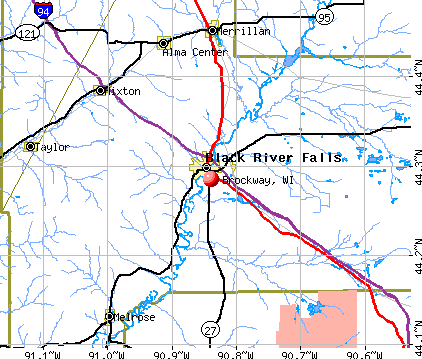
- OSM Map
- General Map
- Google Map
- MSN Map
Population change since 2000: +9.6%
 |
| Males: 1,890 | |
| Females: 938 |
| Median resident age: | 35.9 years |
| Wisconsin median age: | 42.6 years |
Zip codes: 54615.
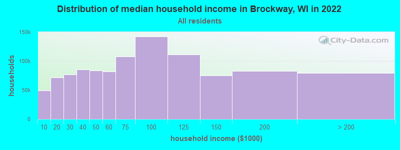
| Brockway: | $59,056 |
| WI: | $70,996 |
Estimated per capita income in 2022: $27,328 (it was $14,709 in 2000)
Brockway town income, earnings, and wages data
Estimated median house or condo value in 2022: $144,977 (it was $61,200 in 2000)
| Brockway: | $144,977 |
| WI: | $252,800 |
Mean prices in 2022: all housing units: $226,121; detached houses: $233,455; townhouses or other attached units: over $1,000,000; in 2-unit structures: $85,201; mobile homes: $82,869; occupied boats, rvs, vans, etc.: $174,831
Detailed information about poverty and poor residents in Brockway, WI
Compare current foreclosures near Brockway, WI:
| Photo | Address | Area | Beds / Baths | Price | Details |
|---|---|---|---|---|---|

|
#1
Riverview Dr, Apt 2210
Black River Falls, WI 54615
|
- sq. feet
|
- baths - beds |
show details | |

|
#2
E 3rd St
Black River Falls, WI 54615
|
- sq. feet
|
- baths - beds |
show details | |

|
#3
Sunset Pl
Taylor, WI 54659
|
- sq. feet
|
- baths - beds |
show details | |

|
#4
N Highland Ave
Taylor, WI 54659
|
- sq. feet
|
- baths - beds |
show details | |

|
#5
E Hogg St # 704
Melrose, WI 54642
|
- sq. feet
|
- baths - beds |
show details | |

|
#6
Selmer Rd
Melrose, WI 54642
|
- sq. feet
|
- baths - beds |
show details | |

|
#7
King Rd
Hixton, WI 54635
|
- sq. feet
|
- baths - beds |
show details | |

|
#8
S Sechlerville Rd
Hixton, WI 54635
|
- sq. feet
|
- baths - beds |
show details | |

|
#9
Sand Rd
Merrillan, WI 54754
|
- sq. feet
|
- baths - beds |
show details | |

|
#10
County Road Ff
Alma Center, WI 54611
|
- sq. feet
|
- baths - beds |
show details |
| Photo | Address | Area | Beds / Baths | Price | Details |
|---|---|---|---|---|---|

|
#11
County Road O
Black River Falls, WI 54615
|
- sq. feet
|
- baths - beds |
show details | |

|
#12
County Road O
Black River Falls, WI 54615
|
- sq. feet
|
- baths - beds |
show details | |

|
#13
Us Highway 12
Black River Falls, WI 54615
|
- sq. feet
|
- baths - beds |
show details | |

|
#14
Fillmore St
Black River Falls, WI 54615
|
- sq. feet
|
- baths - beds |
show details | |

|
#15
N 8th St Apt 14d
Black River Falls, WI 54615
|
- sq. feet
|
- baths - beds |
show details | |

|
#16
Timber Creek Cir
Black River Falls, WI 54615
|
- sq. feet
|
- baths - beds |
show details | |

|
#17
State Highway 95
Neillsville, WI 54456
|
- sq. feet
|
- baths - beds |
show details | |

|
#18
2nd St
Hixton, WI 54635
|
- sq. feet
|
- baths - beds |
show details | |

|
#19
S 3rd St
Black River Falls, WI 54615
|
- sq. feet
|
- baths - beds |
show details | |

|
#20
Gilwest St
Black River Falls, WI 54615
|
- sq. feet
|
- baths - beds |
show details |
| Photo | Address | Area | Beds / Baths | Price | Details |
|---|---|---|---|---|---|

|
#21
Gebhardt Rd
Black River Falls, WI 54615
|
- sq. feet
|
- baths - beds |
show details | |

|
#22
S Roosevelt Rd
Black River Falls, WI 54615
|
- sq. feet
|
- baths - beds |
show details | |

|
Check over 1 million property listings on Foreclosure.com!
|
browse all offers | |||

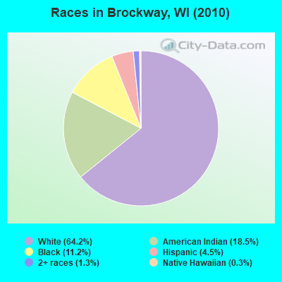
- 1,81564.2%White alone
- 52318.5%American Indian alone
- 31611.2%Black alone
- 1264.5%Hispanic
- 381.3%Two or more races
- 90.3%Native Hawaiian and Other
Pacific Islander alone - 10.04%Asian alone
Races in Brockway detailed stats: ancestries, foreign born residents, place of birth
 Recent articles from our blog. Our writers, many of them Ph.D. graduates or candidates, create easy-to-read articles on a wide variety of topics.

 | Best Hiking Trails in Wisconsin? (31 replies) |
Latest news from Brockway, WI collected exclusively by city-data.com from local newspapers, TV, and radio stations
Ancestries: German (17.2%), Norwegian (11.7%), Irish (4.1%), Polish (3.4%), English (2.8%), Swedish (2.2%).
Current Local Time: CST time zone
Elevation: 838 feet
Land area: 47.7 square miles.
Population density: 59 people per square mile (very low).
56 residents are foreign born (1.2% Asia, 0.7% Latin America, 0.2% Europe).
| This town: | 2.2% |
| Wisconsin: | 3.6% |
| Brockway town: | 2.0% ($1,246) |
| Wisconsin: | 2.0% ($2,245) |
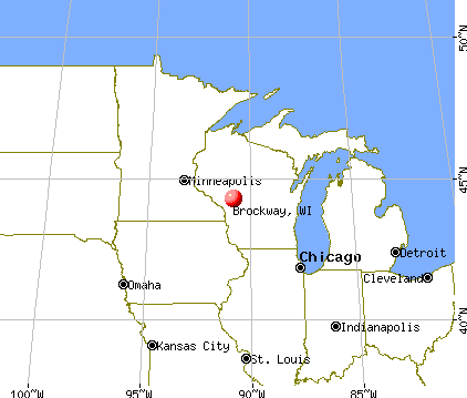
Nearest city with pop. 50,000+: La Crosse, WI  (40.1 miles , pop. 51,818).
Nearest city with pop. 200,000+: Madison, WI (109.9 miles , pop. 208,054).
Nearest city with pop. 1,000,000+: Chicago, IL (231.7 miles , pop. 2,896,016).
Nearest cities:
), ), ), )Latitude: 44.30 N, Longitude: 90.79 W
Area code commonly used in this area: 715

| Here: | 4.1% |
| Wisconsin: | 2.7% |
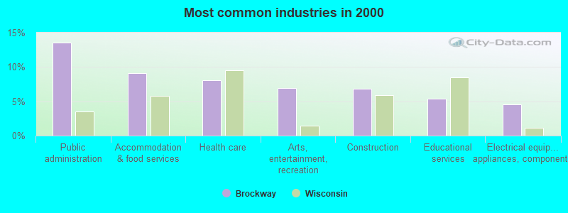
- Public administration (13.6%)
- Accommodation & food services (9.2%)
- Health care (8.1%)
- Arts, entertainment, recreation (6.9%)
- Construction (6.8%)
- Educational services (5.4%)
- Electrical equipment, appliances, components (4.6%)
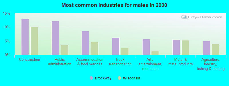
- Construction (13.0%)
- Public administration (12.2%)
- Accommodation & food services (8.6%)
- Truck transportation (6.2%)
- Arts, entertainment, recreation (5.7%)
- Metal & metal products (5.5%)
- Agriculture, forestry, fishing & hunting (4.9%)
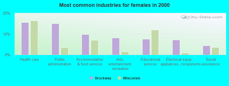
- Health care (15.5%)
- Public administration (15.0%)
- Accommodation & food services (9.7%)
- Arts, entertainment, recreation (8.2%)
- Educational services (7.6%)
- Electrical equipment, appliances, components (7.1%)
- Social assistance (4.5%)
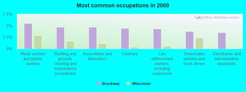
- Metal workers and plastic workers (5.5%)
- Building and grounds cleaning and maintenance occupations (4.7%)
- Assemblers and fabricators (4.7%)
- Cashiers (4.4%)
- Law enforcement workers, including supervisors (4.3%)
- Driver/sales workers and truck drivers (3.8%)
- Secretaries and administrative assistants (3.5%)
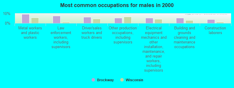
- Metal workers and plastic workers (9.4%)
- Law enforcement workers, including supervisors (7.5%)
- Driver/sales workers and truck drivers (6.5%)
- Other production occupations, including supervisors (5.5%)
- Electrical equipment mechanics and other installation, maintenance, and repair workers, including supervisors (5.5%)
- Building and grounds cleaning and maintenance occupations (5.5%)
- Construction laborers (3.9%)
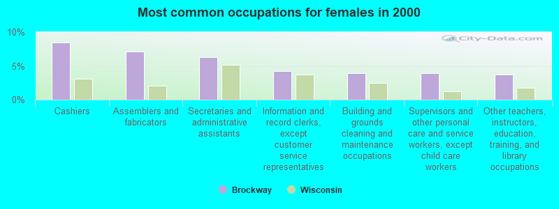
- Cashiers (8.4%)
- Assemblers and fabricators (7.1%)
- Secretaries and administrative assistants (6.3%)
- Information and record clerks, except customer service representatives (4.2%)
- Building and grounds cleaning and maintenance occupations (3.9%)
- Supervisors and other personal care and service workers, except child care workers (3.9%)
- Other teachers, instructors, education, training, and library occupations (3.7%)
Average climate in Brockway, Wisconsin
Based on data reported by over 4,000 weather stations


(lower is better)
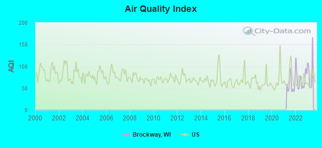
Air Quality Index (AQI) level in 2022 was 69.9. This is about average.
| City: | 69.9 |
| U.S.: | 72.6 |
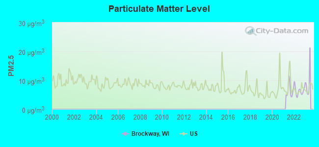
Particulate Matter (PM2.5) [µg/m3] level in 2022 was 6.34. This is better than average. Closest monitor was 2.4 miles away from the city center.
| City: | 6.34 |
| U.S.: | 8.11 |
Tornado activity:
Brockway-area historical tornado activity is near Wisconsin state average. It is 10% greater than the overall U.S. average.
On 4/19/1957, a category F4 (max. wind speeds 207-260 mph) tornado 36.5 miles away from the Brockway town center killed one person and caused between $5000 and $50,000 in damages.
On 5/5/1965, a category F3 (max. wind speeds 158-206 mph) tornado 17.7 miles away from the town center injured 7 people and caused between $500,000 and $5,000,000 in damages.
Earthquake activity:
Brockway-area historical earthquake activity is significantly above Wisconsin state average. It is 25% greater than the overall U.S. average.On 7/9/1975 at 14:54:15, a magnitude 4.6 (4.6 MB, Class: Light, Intensity: IV - V) earthquake occurred 273.5 miles away from Brockway center
On 6/28/2004 at 06:10:52, a magnitude 4.2 (4.2 MW, Depth: 6.2 mi) earthquake occurred 218.7 miles away from Brockway center
On 4/18/2008 at 09:36:59, a magnitude 5.4 (5.1 MB, 4.8 MS, 5.4 MW, 5.2 MW, Class: Moderate, Intensity: VI - VII) earthquake occurred 431.7 miles away from Brockway center
On 6/10/1987 at 23:48:54, a magnitude 5.1 (4.9 MB, 4.4 MS, 4.6 MS, 5.1 LG) earthquake occurred 407.7 miles away from Brockway center
On 4/18/2008 at 09:36:59, a magnitude 5.2 (5.2 MW, Depth: 8.9 mi) earthquake occurred 431.7 miles away from Brockway center
On 2/10/2010 at 09:59:35, a magnitude 3.8 (3.8 MW, Depth: 6.2 mi, Class: Light, Intensity: II - III) earthquake occurred 198.6 miles away from Brockway center
Magnitude types: regional Lg-wave magnitude (LG), body-wave magnitude (MB), surface-wave magnitude (MS), moment magnitude (MW)
Natural disasters:
The number of natural disasters in Jackson County (12) is smaller than the US average (15).Major Disasters (Presidential) Declared: 9
Emergencies Declared: 2
Causes of natural disasters: Floods: 9, Storms: 8, Tornadoes: 3, Winds: 2, Drought: 1, Heavy Rain: 1, Hurricane: 1, Landslide: 1, Mudslide: 1, Other: 1 (Note: some incidents may be assigned to more than one category).
Hospitals and medical centers near Brockway:
- GUNDERSEN LUTHERAN RENAL DIALYSIS - BLACK RIVER FALLS (Dialysis Facility, about 3 miles away; BLACK RIVER FALLS, WI)
- BLACK RIVER MEMORIAL HOMECARE (Home Health Center, about 3 miles away; BLACK RIVER FALLS, WI)
- BLACK RIVER MEM HSPTL Critical Access Hospitals (about 3 miles away; BLACK RIVER FALLS, WI)
- FAMILY HERITAGE NURSING AND REHABILITATION CENTER (Nursing Home, about 4 miles away; BLACK RIVER FALLS, WI)
Colleges/universities with over 2000 students nearest to Brockway:
- University of Wisconsin-La Crosse (about 40 miles; La Crosse, WI; Full-time enrollment: 9,837)
- Western Technical College (about 41 miles; La Crosse, WI; FT enrollment: 3,377)
- Viterbo University (about 42 miles; La Crosse, WI; FT enrollment: 2,848)
- Winona State University (about 46 miles; Winona, MN; FT enrollment: 8,397)
- Saint Mary's University of Minnesota (about 49 miles; Winona, MN; FT enrollment: 4,022)
- University of Wisconsin-Eau Claire (about 49 miles; Eau Claire, WI; FT enrollment: 10,143)
- Chippewa Valley Technical College (about 49 miles; Eau Claire, WI; FT enrollment: 4,038)
Points of interest:
Notable locations in Brockway: Levis (A), Majestic Pines Casino (B), Ho-Chunk Nation Tribal Office Building (C), Ho-Chunk Nation Community Center (D). Display/hide their locations on the map
Cemetery: Olson Cemetery (1). Display/hide its location on the map
Reservoirs: Cranberry Flowage (A), Lake 31 3 7 (B), Teal Flowage 7 (C), Teal Flowage (D). Display/hide their locations on the map
Streams, rivers, and creeks: Levis Creek (A), Indian Grave Creek (B), Trowe Drain (C), Coffee Creek (D), Perry Creek (E). Display/hide their locations on the map
Parks in Brockway include: Bauer-Brockway Barrens State Natural Area (1), Castle Mound Pine Forest State Natural Area (2), Castle Mound Recreation Area (3), Perry Creek Recreation Area (4). Display/hide their locations on the map
| This town: | 2.5 people |
| Wisconsin: | 2.4 people |
| This town: | 64.3% |
| Whole state: | 64.4% |
| This town: | 10.3% |
| Whole state: | 7.3% |
Likely homosexual households (counted as self-reported same-sex unmarried-partner households)
- Lesbian couples: 0.0% of all households
- Gay men: 0.1% of all households
| This town: | 16.9% |
| Whole state: | 8.7% |
| This town: | 7.9% |
| Whole state: | 3.7% |
People in group quarters in Brockway in 2010:
- 988 people in state prisons
- 25 people in group homes intended for adults
- 3 people in emergency and transitional shelters (with sleeping facilities) for people experiencing homelessness
188 people in other nonhousehold living situations in 2000
For population 15 years and over in Brockway:
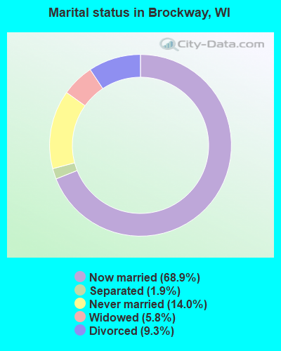
- Never married: 14.0%
- Now married: 68.9%
- Separated: 1.9%
- Widowed: 5.8%
- Divorced: 9.3%
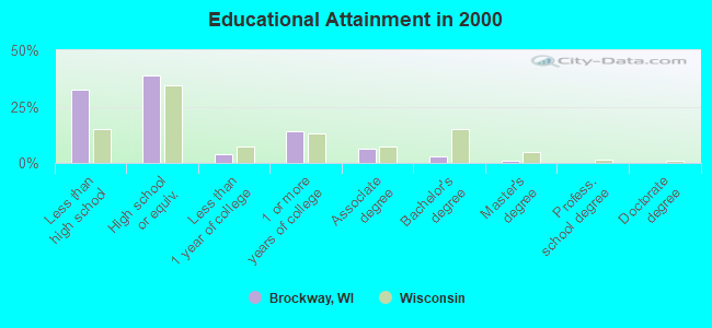
For population 25 years and over in Brockway:
- High school or higher: 67.4%
- Bachelor's degree or higher: 4.1%
- Graduate or professional degree: 1.3%
- Unemployed: 30.6%
- Mean travel time to work (commute): 16.0 minutes
| Here: | 9.5 |
| Wisconsin average: | 11.0 |
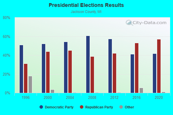
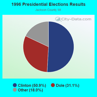
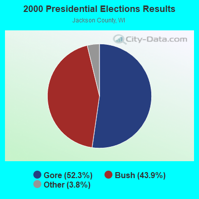
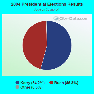
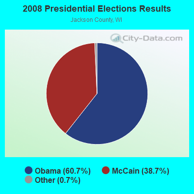
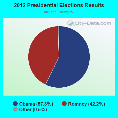
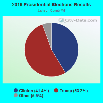
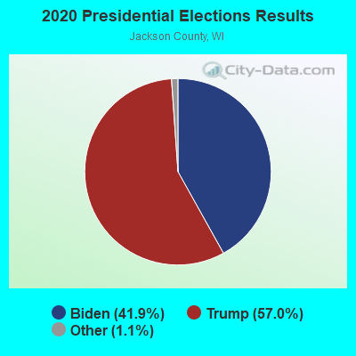
Graphs represent county-level data. Detailed 2008 Election Results
Religion statistics for Brockway, WI (based on Jackson County data)
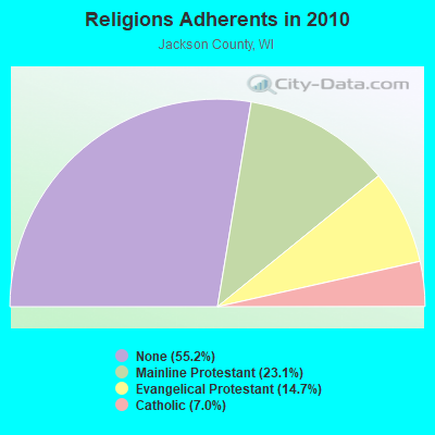
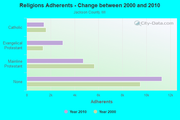
| Religion | Adherents | Congregations |
|---|---|---|
| Mainline Protestant | 4,715 | 17 |
| Evangelical Protestant | 3,008 | 19 |
| Catholic | 1,440 | 3 |
| Other | 1 | 1 |
| None | 11,285 | - |
Food Environment Statistics:
| Jackson County: | 1.51 / 10,000 pop. |
| Wisconsin: | 1.86 / 10,000 pop. |
| Here: | 6.06 / 10,000 pop. |
| Wisconsin: | 4.12 / 10,000 pop. |
| Here: | 9.59 / 10,000 pop. |
| Wisconsin: | 8.64 / 10,000 pop. |
| Jackson County: | 8.7% |
| State: | 7.6% |
| Jackson County: | 28.6% |
| Wisconsin: | 27.5% |
| Here: | 14.5% |
| State: | 13.0% |
Strongest AM radio stations in Brockway:
- WWIS (1260 AM; daytime; 1 kW; BLACK RIVER FALLS, WI; Owner: WWIS RADIO, INC.)
- WSPT (1010 AM; 50 kW; STEVENS POINT, WI)
- WCCN (1370 AM; 5 kW; NEILLSVILLE, WI; Owner: CENTRAL WISCONSIN BROADCASTING, INC.)
- WKLJ (1290 AM; 5 kW; SPARTA, WI; Owner: SPARTA-TOMAH BROADCASTING CO., INC.)
- WSAU (550 AM; 20 kW; WAUSAU, WI; Owner: WRIG, INC.)
- WKTY (580 AM; 5 kW; LA CROSSE, WI; Owner: FAMILY RADIO, INC.)
- WCTS (1030 AM; 50 kW; MAPLEWOOD, MN; Owner: CNTL. BAPT. THEO/AL SEMI MINNEAPOLIS)
- WNAM (1280 AM; 50 kW; NEENAH-MENASHA, WI; Owner: CUMULUS LICENSING CORP.)
- WCCO (830 AM; 50 kW; MINNEAPOLIS, MN; Owner: INFINITY MEDIA CORPORATION)
- WLBL (930 AM; 5 kW; AUBURNDALE, WI; Owner: STATE OF WISCONSIN - EDUCATIONAL COMMUNICATIONS BOARD)
- WEBC (560 AM; 50 kW; DULUTH, MN)
- WMEQ (880 AM; 10 kW; MENOMONIE, WI; Owner: CAPSTAR TX LIMITED PARTNERSHIP)
- KFAN (1130 AM; 50 kW; MINNEAPOLIS, MN; Owner: AMFM RADIO LICENSES, L.L.C.)
Strongest FM radio stations in Brockway:
- WWIS-FM (99.7 FM; BLACK RIVER FALLS, WI; Owner: WWIS RADIO, INC.)
- WAXX (104.5 FM; EAU CLAIRE, WI; Owner: MAVERICK MEDIA OF EAU CLAIRE LICENSE LLC)
- WCCN-FM (107.5 FM; NEILLSVILLE, WI; Owner: CENTRAL WISCONSIN B/CG INC.)
- WCOW-FM (97.1 FM; SPARTA, WI; Owner: SPARTA-TOMAH BROADCASTING CO., INC.)
- WVCX (98.9 FM; TOMAH, WI; Owner: VCY AMERICA, INC.)
- WIZM-FM (93.3 FM; LA CROSSE, WI; Owner: FAMILY RADIO, INC.)
- WHLA (90.3 FM; LA CROSSE, WI; Owner: STATE OF WISCONSIN - EDUCATIONAL COMMUNICATIONS BOARD)
- WXYM (96.1 FM; TOMAH, WI; Owner: MAGNUM RADIO, INC.)
- WBOG (94.5 FM; TOMAH, WI; Owner: MAGNUM RADIO, INC.)
- WHTL-FM (102.3 FM; WHITEHALL, WI; Owner: THE WHTL GROUP, L.L.C.)
- W272AC (102.3 FM; BLACK RIVER FALLS, WI; Owner: SHALOM TRANSLATORS, INC.)
TV broadcast stations around Brockway:
- WEAU-TV (Channel 13; EAU CLAIRE, WI; Owner: WEAU LICENSEE CORP.)
- WDLS-LP (Channel 35; TOMAH, WI; Owner: MAGNUM RADIO, INC.)
- WKBT (Channel 8; LA CROSSE, WI; Owner: QUEENB TELEVISION, LLC)
- WXOW-TV (Channel 19; LA CROSSE, WI; Owner: WXOW-WQOW TELEVISION, INC.)
- National Bridge Inventory (NBI) Statistics
- 14Number of bridges
- 125ft / 37.7mTotal length
- $2,057,000Total costs
- 120,826Total average daily traffic
- 12,393Total average daily truck traffic
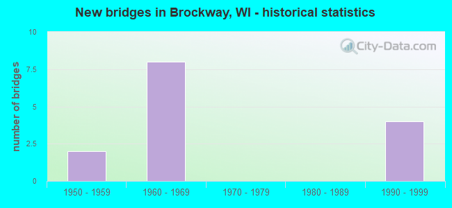
- New bridges - historical statistics
- 21950-1959
- 81960-1969
- 41990-1999
FCC Registered Broadcast Land Mobile Towers:
2- BROCKWAY, W9805 Airport Road (Lat: 44.305778 Lon: -90.801417), Type: Tank, Structure height: 47.2 m, Overall height: 53.9 m, Call Sign: WQQM810,
Assigned Frequencies: 154.740 MHz, 151.062 MHz, 154.445 MHz, 159.135 MHz, 158.827 MHz, Grant Date: 01/10/2023, Expiration Date: 01/29/2033, Certifier: John M Ross, Registrant: Business Radio Licensing, 30251 Golden Lantern, Suite E #501, Laguna Niguel, CA 92677, Phone: (949) 348-8510, Fax: (949) 348-8514, Email:
- BROCKWAY, W9805 Airport Road (Lat: 44.305778 Lon: -90.801417), Type: Tank, Structure height: 47.2 m, Overall height: 53.9 m, Call Sign: WQTH619,
Assigned Frequencies: 151.280 MHz, Grant Date: 01/19/2024, Expiration Date: 02/04/2034, Certifier: Mark J Moan, Registrant: Business Radio Licensing, 30251 Golden Lantern Suite E #501, Laguna Niguel, CA 92677, Phone: (949) 348-8510, Fax: (949) 348-8514, Email:
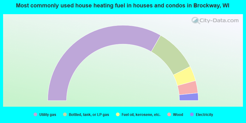
- 66.6%Utility gas
- 18.4%Bottled, tank, or LP gas
- 6.4%Fuel oil, kerosene, etc.
- 5.3%Wood
- 3.2%Electricity
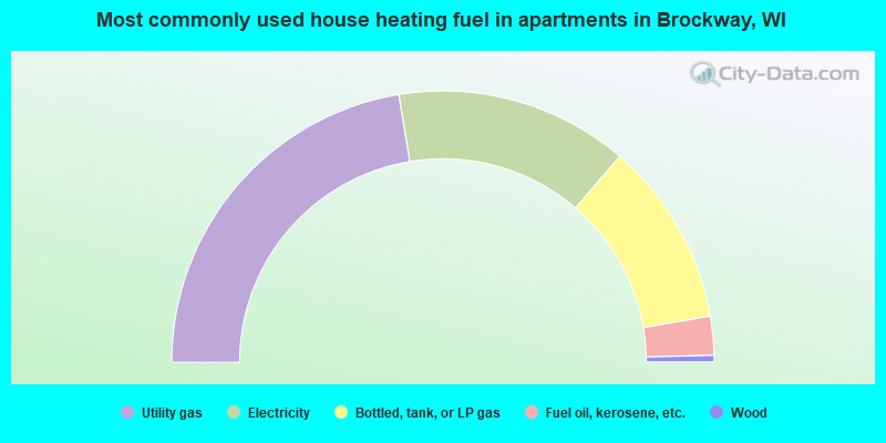
- 44.8%Utility gas
- 27.8%Electricity
- 22.0%Bottled, tank, or LP gas
- 4.6%Fuel oil, kerosene, etc.
- 0.8%Wood
Brockway compared to Wisconsin state average:
- Median house value below state average.
- Unemployed percentage above state average.
- Black race population percentage above state average.
- Median age below state average.
- Foreign-born population percentage significantly below state average.
- Length of stay since moving in significantly above state average.
- Number of rooms per house significantly below state average.
- House age significantly below state average.
- Institutionalized population percentage significantly above state average.
- Percentage of population with a bachelor's degree or higher significantly below state average.
Brockway on our top lists:
- #8 on the list of "Top 101 cities with the largest percentage of people in other nonhousehold living situations (population 1,000+)"
- #71 on the list of "Top 101 cities with the largest percentage of people in state prisons (population 1,000+)"
- #35 (54615) on the list of "Top 101 zip codes with the largest percentage of Norwegian first ancestries (pop 5,000+)"