Brewster-Wakefield, Washington
Submit your own pictures of this place and show them to the world
- OSM Map
- Google Map
- MSN Map
| Males: 2,382 | |
| Females: 2,374 |
| Median resident age: | 29.3 years |
| Washington median age: | 35.3 years |
Zip code: 98812
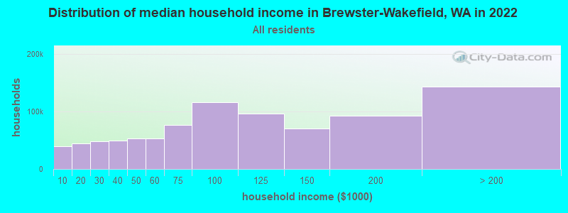
| Brewster-Wakefield: | $51,969 |
| WA: | $91,306 |
Estimated per capita income in 2022: $25,399 (it was $12,189 in 2000)
Brewster-Wakefield CCD income, earnings, and wages data
Estimated median house or condo value in 2022: $329,504 (it was $98,500 in 2000)
| Brewster-Wakefield: | $329,504 |
| WA: | $569,500 |
Mean prices in 2022: all housing units: $367,366; detached houses: $412,379; townhouses or other attached units: $395,958; in 2-unit structures: $248,549; in 3-to-4-unit structures: $332,393; in 5-or-more-unit structures: $283,125; mobile homes: $164,657; occupied boats, rvs, vans, etc.: $50,738
Brewster-Wakefield, WA residents, houses, and apartments details
Detailed information about poverty and poor residents in Brewster-Wakefield, WA


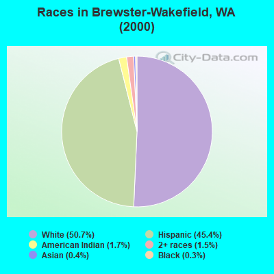
- 2,40850.7%White alone
- 2,15745.4%Hispanic
- 831.7%American Indian alone
- 691.5%Two or more races
- 210.4%Asian alone
- 120.3%Black alone
- 20.04%Other race alone
Races in Brewster-Wakefield detailed stats: ancestries, foreign born residents, place of birth
 Recent articles from our blog. Our writers, many of them Ph.D. graduates or candidates, create easy-to-read articles on a wide variety of topics.
Current Local Time: PST time zone
Land area: 209.0 square miles.
Population density: 23 people per square mile (very low).
| Brewster-Wakefield CCD: | 1.1% ($1,102) |
| Washington: | 1.2% ($1,915) |
Nearest city with pop. 50,000+: Issaquah Plateau, WA (111.1 miles  , pop. 50,237).
Nearest city with pop. 200,000+: East Seattle, WA (116.0 miles , pop. 480,100).
Nearest city with pop. 1,000,000+: Los Angeles, CA (976.0 miles , pop. 3,694,820).
Nearest cities:
), )Latitude: 48.16 N, Longitude: 119.80 W
Area code commonly used in this area: 509
| Here: | 7.3% |
| Washington: | 4.6% |
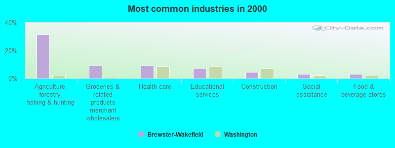
- Agriculture, forestry, fishing & hunting (31.4%)
- Groceries & related products merchant wholesalers (9.2%)
- Health care (9.2%)
- Educational services (7.6%)
- Construction (4.4%)
- Social assistance (3.3%)
- Food & beverage stores (3.2%)
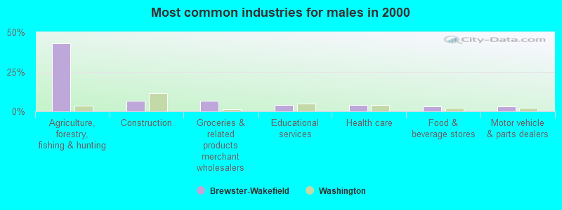
- Agriculture, forestry, fishing & hunting (42.8%)
- Construction (6.7%)
- Groceries & related products merchant wholesalers (6.6%)
- Educational services (4.1%)
- Health care (3.8%)
- Food & beverage stores (3.2%)
- Motor vehicle & parts dealers (3.1%)
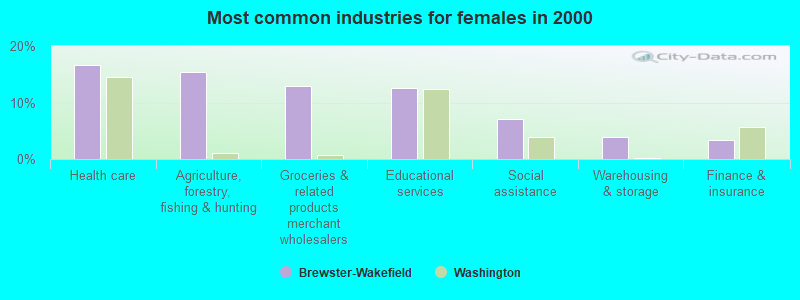
- Health care (16.7%)
- Agriculture, forestry, fishing & hunting (15.4%)
- Groceries & related products merchant wholesalers (13.0%)
- Educational services (12.6%)
- Social assistance (7.0%)
- Warehousing & storage (3.9%)
- Finance & insurance (3.4%)
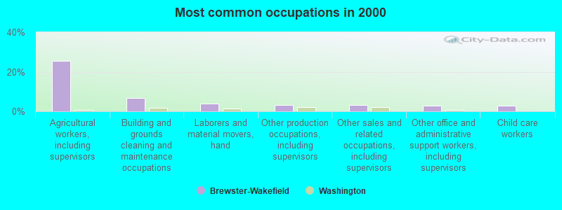
- Agricultural workers, including supervisors (25.3%)
- Building and grounds cleaning and maintenance occupations (6.9%)
- Laborers and material movers, hand (3.9%)
- Other production occupations, including supervisors (3.3%)
- Other sales and related occupations, including supervisors (3.3%)
- Other office and administrative support workers, including supervisors (2.8%)
- Child care workers (2.8%)
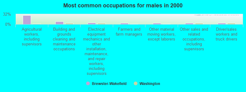
- Agricultural workers, including supervisors (28.3%)
- Building and grounds cleaning and maintenance occupations (8.8%)
- Electrical equipment mechanics and other installation, maintenance, and repair workers, including supervisors (4.4%)
- Farmers and farm managers (4.3%)
- Other material moving workers, except laborers (4.0%)
- Other sales and related occupations, including supervisors (4.0%)
- Driver/sales workers and truck drivers (4.0%)
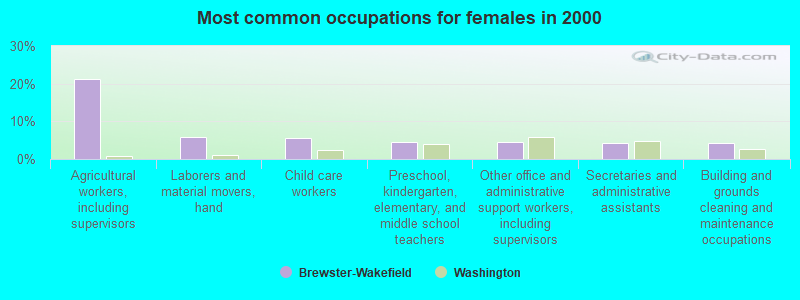
- Agricultural workers, including supervisors (21.1%)
- Laborers and material movers, hand (5.8%)
- Child care workers (5.6%)
- Preschool, kindergarten, elementary, and middle school teachers (4.4%)
- Other office and administrative support workers, including supervisors (4.4%)
- Secretaries and administrative assistants (4.3%)
- Building and grounds cleaning and maintenance occupations (4.1%)
Average climate in Brewster-Wakefield, Washington
Based on data reported by over 4,000 weather stations


(lower is better)
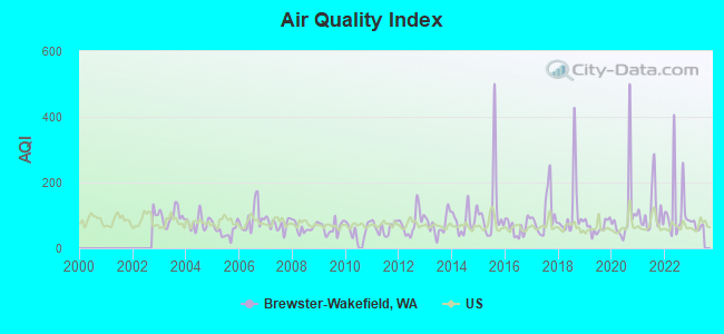
Air Quality Index (AQI) level in 2022 was 121. This is significantly worse than average.
| City: | 121 |
| U.S.: | 73 |
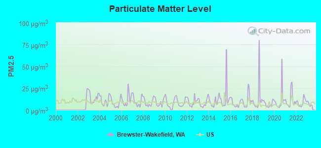
Particulate Matter (PM2.5) [µg/m3] level in 2022 was 8.77. This is about average. Closest monitor was 20.7 miles away from the city center.
| City: | 8.77 |
| U.S.: | 8.11 |
Earthquake activity:
Brewster-Wakefield-area historical earthquake activity is significantly above Washington state average. It is 1069% greater than the overall U.S. average.On 4/13/1949 at 19:55:42, a magnitude 7.0 (7.0 UK, Class: Major, Intensity: VIII - XII) earthquake occurred 140.5 miles away from Brewster-Wakefield center, causing $80,000,000 total damage
On 2/28/2001 at 18:54:32, a magnitude 6.8 (6.5 MB, 6.6 MS, 6.8 MW, Class: Strong, Intensity: VII - IX) earthquake occurred 149.2 miles away from Brewster-Wakefield center, causing $2,000,000,000 total damage and $305,000,000 insured losses
On 2/28/2001 at 18:54:32, a magnitude 6.8 (6.8 MD, Depth: 32.2 mi) earthquake occurred 153.2 miles away from Brewster-Wakefield center
On 4/29/1965 at 15:28:43, a magnitude 6.6 (6.6 UK) earthquake occurred 131.4 miles away from the city center, causing $28,000,000 total damage
On 10/28/1983 at 14:06:06, a magnitude 7.3 (6.2 MB, 7.3 MS, 7.0 MW) earthquake occurred 402.6 miles away from Brewster-Wakefield center, causing 2 deaths (2 shaking deaths) and 3 injuries, causing $15,000,000 total damage
On 8/18/1959 at 06:37:13, a magnitude 7.7 (7.7 UK) earthquake occurred 501.7 miles away from Brewster-Wakefield center, causing $26,000,000 total damage
Magnitude types: body-wave magnitude (MB), duration magnitude (MD), surface-wave magnitude (MS), moment magnitude (MW)
Natural disasters:
The number of natural disasters in Okanogan County (21) is greater than the US average (15).Major Disasters (Presidential) Declared: 9
Emergencies Declared: 3
Causes of natural disasters: Fires: 13, Floods: 5, Storms: 3, Mudslides: 2, Heavy Rain: 1, Hurricane: 1, Volcanic Eruption: 1, Wind: 1, Winter Storm: 1, Other: 1 (Note: some incidents may be assigned to more than one category).
Colleges/universities with over 2000 students nearest to Brewster-Wakefield:
- Wenatchee Valley College (about 57 miles; Wenatchee, WA; Full-time enrollment: 2,951)
- Central Washington University (about 87 miles; Ellensburg, WA; FT enrollment: 10,960)
- Everett Community College (about 112 miles; Everett, WA; FT enrollment: 5,818)
- Eastern Washington University (about 113 miles; Cheney, WA; FT enrollment: 11,643)
- Spokane Falls Community College (about 114 miles; Spokane, WA; FT enrollment: 6,052)
- Whitworth University (about 114 miles; Spokane, WA; FT enrollment: 2,689)
- Yakima Valley Community College (about 114 miles; Yakima, WA; FT enrollment: 3,632)
Points of interest:
Notable locations in Brewster-Wakefield: Chief Joseph (A), Gambles Mill (B), Kercheval Ranch (C), Columbia Cove Recreational Vehicle Park (D), Lightning Pine Recreational Vehicle Park (E), Brewster Sewage Treatment Plant (F), Fort Okanogan Overlook (G), Douglas - Okanogan County Fire District 15 Brewster Station 20 (H), Douglas - Okanogan County Fire District 15 Pateros Station 10 (I), Brewster Flat Earth Station (J), Knowlton (K), Harmony House Health Care Center (L), Brewster City Fire Department (M), Pateros Fire Department (N). Display/hide their locations on the map
Churches in Brewster-Wakefield include: Brewster Adventist Church (A), Brewster Assembly of God Church (B), Calvary Baptist Church (C), New Testament Baptist Church (D), Sacred Heart Catholic Church (E), The Church of Jesus Christ of Latter Day Saints (F), Pateros United Methodist Church (G). Display/hide their locations on the map
Cemeteries: Locust Grove Cemetery (1), Chiliwist Cemetery (2). Display/hide their locations on the map
Lakes and reservoirs: Starzman Lake (A), Rowel Lake (B), Crazy Rapids Reservoir (C), Indian Dan Canyon Reservoir (D), Rat Lake (E), McKie Pond (F). Display/hide their locations on the map
Creeks: Hooker Creek (A), Squaw Creek (B), Sullivan Creek (C), Swamp Creek (D), Whitestone Creek (E). Display/hide their locations on the map
Parks in Brewster-Wakefield include: Indian Dan State Wildlife Recreation Area (1), Inning Field (2). Display/hide their locations on the map
| This place: | 3.0 people |
| Washington: | 2.5 people |
| This place: | 74.8% |
| Whole state: | 64.4% |
| This place: | 6.4% |
| Whole state: | 7.7% |
Likely homosexual households (counted as self-reported same-sex unmarried-partner households)
- Lesbian couples: 0.3% of all households
- Gay men: 0.4% of all households
| This place: | 28.5% |
| Whole state: | 10.6% |
| This place: | 8.5% |
| Whole state: | 4.6% |
People in group quarters in Brewster-Wakefield in 2010:
- 61 people in nursing facilities/skilled-nursing facilities
- 9 people in workers' group living quarters and job corps centers
- 5 people in correctional residential facilities
People in group quarters in Brewster-Wakefield in 2000:
- 51 people in nursing homes
- 28 people in agriculture workers' dormitories on farms
- 10 people in unknown juvenile institutions
- 6 people in other noninstitutional group quarters
For population 15 years and over in Brewster-Wakefield:
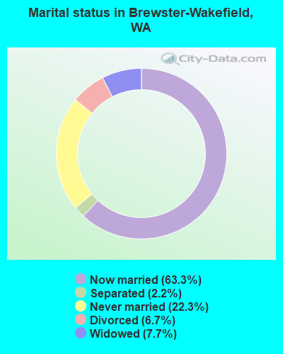
- Never married: 22.3%
- Now married: 63.3%
- Separated: 2.2%
- Widowed: 7.7%
- Divorced: 6.7%
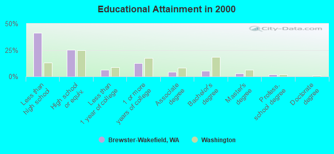
For population 25 years and over in Brewster-Wakefield:
- High school or higher: 58.9%
- Bachelor's degree or higher: 10.2%
- Graduate or professional degree: 4.9%
- Unemployed: 10.7%
- Mean travel time to work (commute): 16.1 minutes
| Here: | 21.9 |
| Washington average: | 11.3 |
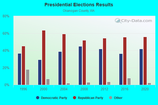
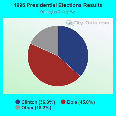
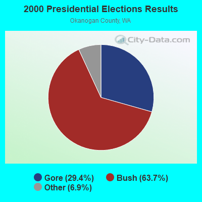
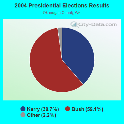
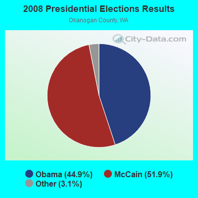
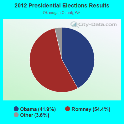
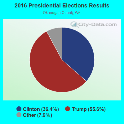
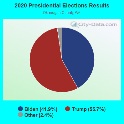
Graphs represent county-level data. Detailed 2008 Election Results
Religion statistics for Brewster-Wakefield, WA (based on Okanogan County data)
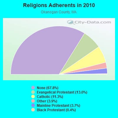
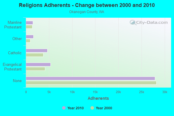
| Religion | Adherents | Congregations |
|---|---|---|
| Evangelical Protestant | 5,331 | 54 |
| Catholic | 4,627 | 7 |
| Other | 1,599 | 10 |
| Mainline Protestant | 1,517 | 14 |
| Black Protestant | 183 | 1 |
| None | 27,863 | - |
Food Environment Statistics:
| Here: | 4.30 / 10,000 pop. |
| Washington: | 2.06 / 10,000 pop. |
| Okanogan County: | 1.27 / 10,000 pop. |
| Washington: | 1.18 / 10,000 pop. |
| Here: | 6.58 / 10,000 pop. |
| Washington: | 2.67 / 10,000 pop. |
| Okanogan County: | 10.38 / 10,000 pop. |
| Washington: | 8.26 / 10,000 pop. |
| Okanogan County: | 9.2% |
| Washington: | 7.7% |
| Okanogan County: | 26.8% |
| Washington: | 25.7% |
| Okanogan County: | 16.4% |
| Washington: | 13.9% |
Strongest AM radio stations in Brewster-Wakefield:
- KTBI (810 AM; daytime; 50 kW; EPHRATA, WA; Owner: TACOMA BROADCASTERS, INCORPORATED)
- KOMW (680 AM; daytime; 5 kW; OMAK, WA; Owner: NORTH CASCADES BROADCASTING, INC.)
- KIXI (880 AM; 50 kW; MERCER ISLAND/SEATTL, WA; Owner: BELLEVUE RADIO, INC.)
- KIRO (710 AM; 50 kW; SEATTLE, WA; Owner: ENTERCOM SEATTLE LICENSE, LLC)
- KTTH (770 AM; 50 kW; SEATTLE, WA; Owner: ENTERCOM SEATTLE LICENSE, LLC)
- KGNW (820 AM; 50 kW; BURIEN-SEATTLE, WA; Owner: INSPIRATION MEDIA, INC.)
- KRKO (1380 AM; 50 kW; EVERETT, WA; Owner: S-R BROADCASTING, CO.)
- KOMO (1000 AM; 50 kW; SEATTLE, WA; Owner: FISHER BROADCASTING - SEATTLE RADIO, L.L.C.)
- KJR (950 AM; 50 kW; SEATTLE, WA)
- KPQ (560 AM; 5 kW; WENATCHEE, WA; Owner: WESTCOAST BROADCASTING CO.)
- KYCW (1090 AM; 50 kW; SEATTLE, WA; Owner: INFINITY RADIO SUBSIDIARY OPERATIONS INC.)
- KGA (1510 AM; 50 kW; SPOKANE, WA; Owner: CITADEL BROADCASTING COMPANY)
- KKOL (1300 AM; 50 kW; SEATTLE, WA; Owner: INSPIRATION MEDIA, INC.)
Strongest FM radio stations in Brewster-Wakefield:
- K257DN (99.3 FM; BREWSTER, WA; Owner: BREWSTER GRANGE #1018)
- K236AE (95.1 FM; TWISP, WA; Owner: NORTH CASCADES BROADCASTING, INC.)
- KVLR (106.3 FM; TWISP, WA; Owner: VALLEY AIR LLC.)
- KZBE (104.3 FM; OMAK, WA; Owner: NORTH CASCADES BROADCASTING, INC.)
- K219DQ (90.5 FM; OMAK, WA; Owner: WALLA WALLA COLLEGE)
- KOZI-FM (93.5 FM; CHELAN, WA; Owner: ICICLE BROADCASTING, INC.)
- KQWS (90.1 FM; OMAK, WA; Owner: WASHINGTON STATE UNIVERSITY)
- KNCW (92.7 FM; OMAK, WA; Owner: NORTH CASCADES BROADCASTING, INC.)
- KOHO-FM (101.1 FM; LEAVENWORTH, WA; Owner: ICICLE BROADCASTING, INC.)
- KPQ-FM (102.1 FM; WENATCHEE, WA; Owner: WESCOAST BROADCASTING COMPANY)
- KNWR (90.7 FM; ELLENSBURG, WA; Owner: WASHINGTON STATE UNIVERSITY)
- KEYG-FM (98.5 FM; GRAND COULEE, WA; Owner: WHEELER BROADCASTING, INC.)
- KKRV (104.7 FM; WENATCHEE, WA; Owner: MCC RADIO, LLC)
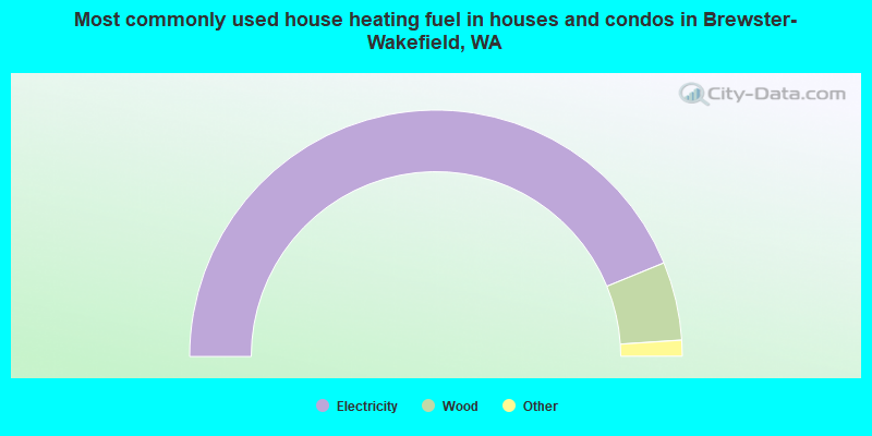
- 87.7%Electricity
- 10.3%Wood
- 1.0%Bottled, tank, or LP gas
- 0.8%Fuel oil, kerosene, etc.
- 0.2%No fuel used
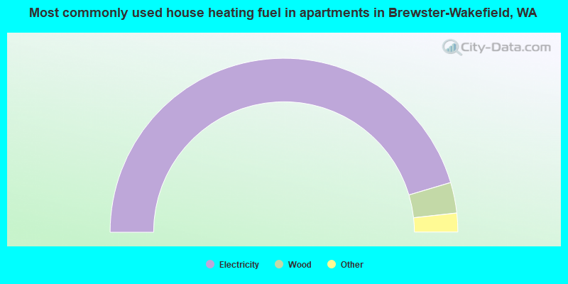
- 90.7%Electricity
- 5.7%Wood
- 1.2%Bottled, tank, or LP gas
- 0.9%Fuel oil, kerosene, etc.
- 0.8%No fuel used
- 0.6%Other fuel
Brewster-Wakefield compared to Washington state average:
- Median household income below state average.
- Median house value below state average.
- Black race population percentage significantly below state average.
- Hispanic race population percentage significantly above state average.
- Foreign-born population percentage significantly below state average.
- Length of stay since moving in significantly above state average.
- Number of rooms per house significantly below state average.
- House age significantly below state average.
- Number of college students below state average.
- Percentage of population with a bachelor's degree or higher significantly below state average.