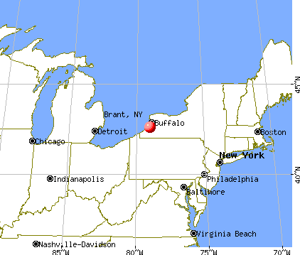
Brant, New York
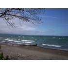
Brant: Brant's Best Secret "The Lake"

Brant: Brant's Best Secret "The Lake"

Brant: Brant's Best Secret "The Lake"
- add
your
Submit your own pictures of this town and show them to the world
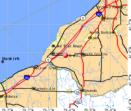
- OSM Map
- General Map
- Google Map
- MSN Map
Population change since 2000: +8.3%
 |
| Males: 1,040 | |
| Females: 1,025 |
| Median resident age: | 43.0 years |
| New York median age: | 40.7 years |
Zip codes: 14081.
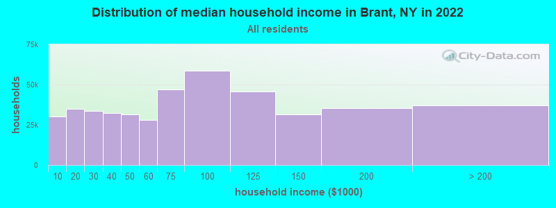
| Brant: | $76,001 |
| NY: | $79,557 |
Estimated per capita income in 2022: $39,755 (it was $19,803 in 2000)
Brant town income, earnings, and wages data
Estimated median house or condo value in 2022: $217,415 (it was $85,000 in 2000)
| Brant: | $217,415 |
| NY: | $400,400 |
Mean prices in 2022: all housing units: $244,055; detached houses: $258,042; townhouses or other attached units: $217,708; in 2-unit structures: $199,670; in 3-to-4-unit structures: $213,644; in 5-or-more-unit structures: $334,912; mobile homes: $67,367; occupied boats, rvs, vans, etc.: $89,496
Detailed information about poverty and poor residents in Brant, NY
Compare current foreclosures near Brant, NY:
| Photo | Address | Area | Beds / Baths | Price | Details |
|---|---|---|---|---|---|

|
#1
W Doughty St
Dunkirk, NY 14048
|
1,600 sq. feet
|
2 baths 4 beds |
$109,900
|
show details |

|
#2
N Boston Rd
Eden, NY 14057
|
792 sq. feet
|
1 baths 3 beds |
$45,000
|
show details |

|
#3
King St
Dunkirk, NY 14048
|
1,219 sq. feet
|
2 baths 3 beds |
$98,900
|
show details |

|
#4
Eastwood Ave
Hamburg, NY 14075
|
2,206 sq. feet
|
2 baths 3 beds |
show details | |

|
#5
Park Ave
Dunkirk, NY 14048
|
1,560 sq. feet
|
1 baths 3 beds |
show details | |

|
#6
Mixer Rd
Forestville, NY 14062
|
1,930 sq. feet
|
2 baths 4 beds |
show details | |

|
#7
Quebec St
Angola, NY 14006
|
1,262 sq. feet
|
1 baths 3 beds |
show details | |

|
#8
Seufert Rd
Orchard Park, NY 14127
|
1,212 sq. feet
|
1 baths 3 beds |
show details | |

|
#9
Vermont St
North Collins, NY 14111
|
1,864 sq. feet
|
1 baths 5 beds |
show details | |

|
#10
Main St
Collins, NY 14034
|
2,560 sq. feet
|
1 baths 4 beds |
show details |
| Photo | Address | Area | Beds / Baths | Price | Details |
|---|---|---|---|---|---|

|
#11
Hampton Brook Dr
Hamburg, NY 14075
|
2,065 sq. feet
|
2 baths 3 beds |
show details | |

|
#12
Enser Rd
Eden, NY 14057
|
2,270 sq. feet
|
2 baths 4 beds |
show details | |

|
#13
Peck Hill Rd
Gowanda, NY 14070
|
2,128 sq. feet
|
2 baths 3 beds |
show details | |

|
#14
Brant Farnham Rd
Irving, NY 14081
|
1,414 sq. feet
|
1 baths 2 beds |
show details | |

|
#15
Pleasant Ave
Hamburg, NY 14075
|
2,270 sq. feet
|
2 baths 4 beds |
show details | |

|
#16
Southwestern Blvd
Hamburg, NY 14075
|
1,620 sq. feet
|
1 baths 3 beds |
show details | |

|
#17
Central Ave
Hamburg, NY 14075
|
2,531 sq. feet
|
2 baths 4 beds |
show details | |

|
#18
Chapman Pkwy
Hamburg, NY 14075
|
1,638 sq. feet
|
1 baths 3 beds |
show details | |

|
#19
Route 62
Gowanda, NY 14070
|
900 sq. feet
|
1 baths 3 beds |
show details | |

|
#20
Maple Ave
Hamburg, NY 14075
|
1,650 sq. feet
|
2 baths 3 beds |
show details |
| Photo | Address | Area | Beds / Baths | Price | Details |
|---|---|---|---|---|---|

|
#21
Blake Ln
Hamburg, NY 14075
|
1,252 sq. feet
|
1 baths 3 beds |
show details | |

|
#22
New Oregon Rd
North Collins, NY 14111
|
731 sq. feet
|
1 baths 3 beds |
show details | |

|
#23
Palmer St
Gowanda, NY 14070
|
1,548 sq. feet
|
1 baths 3 beds |
show details | |

|
#24
Hardpan Rd
Angola, NY 14006
|
1,853 sq. feet
|
1 baths 3 beds |
show details | |

|
#25
Eckhardt Rd
Hamburg, NY 14075
|
1,600 sq. feet
|
1 baths 3 beds |
show details | |

|
#26
Beech St
Gowanda, NY 14070
|
1,072 sq. feet
|
1 baths 2 beds |
show details | |

|
#27
S Quaker Rd
Gowanda, NY 14070
|
1,848 sq. feet
|
1 baths 3 beds |
show details | |

|
#28
Van Etten Rd
Gowanda, NY 14070
|
1,860 sq. feet
|
2 baths 6 beds |
show details | |

|
#29
New Oregon Rd
Eden, NY 14057
|
2,500 sq. feet
|
2 baths 5 beds |
show details | |

|
#30
Erie Ave
Gowanda, NY 14070
|
2,087 sq. feet
|
2 baths 6 beds |
show details |
| Photo | Address | Area | Beds / Baths | Price | Details |
|---|---|---|---|---|---|

|
#31
Fox Ave
North Collins, NY 14111
|
2,280 sq. feet
|
3 baths 6 beds |
show details | |

|
#32
Maple Ave
Gowanda, NY 14070
|
2,107 sq. feet
|
1 baths 4 beds |
show details | |

|
#33
Harbor Run Ln
Lake View, NY 14085
|
1,170 sq. feet
|
1 baths 3 beds |
show details | |

|
#34
Maple Ave
Gowanda, NY 14070
|
1,791 sq. feet
|
1 baths 3 beds |
show details | |

|
#35
Maple Ave
Gowanda, NY 14070
|
1,120 sq. feet
|
1 baths 2 beds |
show details | |

|
#36
Mechanic St
Gowanda, NY 14070
|
1,926 sq. feet
|
2 baths 4 beds |
show details | |

|
#37
Walbridge Dr
Hamburg, NY 14075
|
1,386 sq. feet
|
1 baths 2 beds |
show details | |

|
#38
Lake Shore Rd
Hamburg, NY 14075
|
1,136 sq. feet
|
1 baths 3 beds |
show details | |

|
#39
Kennison Pkwy
Hamburg, NY 14075
|
1,450 sq. feet
|
1 baths 3 beds |
show details | |

|
#40
Glenwillow Dr
Hamburg, NY 14075
|
1,176 sq. feet
|
1 baths 3 beds |
show details |
| Photo | Address | Area | Beds / Baths | Price | Details |
|---|---|---|---|---|---|

|
#41
Omphalius Rd
Colden, NY 14033
|
2,128 sq. feet
|
2 baths 3 beds |
show details | |

|
#42
Mcallister Rd
Fredonia, NY 14063
|
2,488 sq. feet
|
2 baths 3 beds |
show details | |

|
#43
S Park Ave
Buffalo, NY 14219
|
1,830 sq. feet
|
2 baths 3 beds |
show details | |

|
#44
Grote Rd
Springville, NY 14141
|
1,652 sq. feet
|
1 baths 2 beds |
show details | |

|
#45
E 7th St
Dunkirk, NY 14048
|
1,712 sq. feet
|
1 baths 4 beds |
show details | |

|
#46
Tisbury Ln
Hamburg, NY 14075
|
2,245 sq. feet
|
2 baths 3 beds |
show details | |

|
#47
Alexander Way
Orchard Park, NY 14127
|
2,044 sq. feet
|
2 baths 3 beds |
show details | |

|
#48
W Doughty St
Dunkirk, NY 14048
|
1,440 sq. feet
|
1 baths 3 beds |
show details | |

|
#49
Short Dr
Orchard Park, NY 14127
|
1,848 sq. feet
|
2 baths 4 beds |
show details | |

|
Check over 1 million property listings on Foreclosure.com!
|
browse all offers | |||

- 1,86890.5%White alone
- 934.5%American Indian alone
- 572.8%Hispanic
- 261.3%Two or more races
- 201.0%Black alone
- 10.05%Asian alone
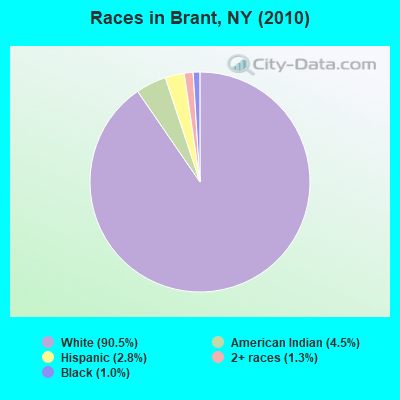
Races in Brant detailed stats: ancestries, foreign born residents, place of birth
Type |
2009 |
2010 |
2011 |
2012 |
2013 |
2014 |
2015 |
2016 |
2017 |
2018 |
2019 |
2020 |
2022 |
|---|---|---|---|---|---|---|---|---|---|---|---|---|---|
| Murders (per 100,000) | 0 (0.0) | 0 (0.0) | 0 (0.0) | 0 (0.0) | 0 (0.0) | 0 (0.0) | 0 (0.0) | 0 (0.0) | 0 (0.0) | 0 (0.0) | 0 (0.0) | 0 (0.0) | 0 (0.0) |
| Rapes (per 100,000) | 0 (0.0) | 0 (0.0) | 0 (0.0) | 0 (0.0) | 0 (0.0) | 0 (0.0) | 0 (0.0) | 0 (0.0) | 2 (97.3) | 0 (0.0) | 0 (0.0) | 0 (0.0) | 0 (0.0) |
| Robberies (per 100,000) | 0 (0.0) | 0 (0.0) | 0 (0.0) | 0 (0.0) | 1 (48.4) | 0 (0.0) | 0 (0.0) | 0 (0.0) | 0 (0.0) | 0 (0.0) | 0 (0.0) | 0 (0.0) | 0 (0.0) |
| Assaults (per 100,000) | 1 (55.1) | 1 (48.4) | 1 (48.2) | 2 (96.4) | 3 (145.3) | 1 (48.5) | 1 (48.4) | 1 (48.4) | 0 (0.0) | 0 (0.0) | 0 (0.0) | 0 (0.0) | 0 (0.0) |
| Burglaries (per 100,000) | 5 (275.6) | 10 (484.3) | 4 (192.9) | 4 (192.9) | 9 (435.8) | 9 (436.3) | 3 (145.1) | 4 (193.8) | 3 (146.0) | 4 (193.0) | 0 (0.0) | 1 (48.6) | 3 (156.4) |
| Thefts (per 100,000) | 18 (992.3) | 24 (1,162) | 9 (433.9) | 14 (675.0) | 20 (968.5) | 12 (581.7) | 22 (1,064) | 11 (532.9) | 11 (535.3) | 8 (385.9) | 4 (194.6) | 12 (583.7) | 6 (312.8) |
| Auto thefts (per 100,000) | 0 (0.0) | 0 (0.0) | 0 (0.0) | 2 (96.4) | 2 (96.9) | 0 (0.0) | 1 (48.4) | 2 (96.9) | 1 (48.7) | 2 (96.5) | 1 (48.7) | 2 (97.3) | 0 (0.0) |
| Arson (per 100,000) | 0 (0.0) | 0 (0.0) | 1 (48.2) | 0 (0.0) | 0 (0.0) | 0 (0.0) | 0 (0.0) | 0 (0.0) | 0 (0.0) | 0 (0.0) | 0 (0.0) | 0 (0.0) | 0 (0.0) |
| City-Data.com crime index | 70.0 | 90.1 | 40.5 | 67.5 | 120.6 | 63.5 | 66.2 | 52.3 | 113.4 | 36.7 | 11.7 | 34.5 | 23.5 |
The City-Data.com crime index weighs serious crimes and violent crimes more heavily. Higher means more crime, U.S. average is 246.1. It adjusts for the number of visitors and daily workers commuting into cities.
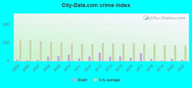
Crime rate in Brant detailed stats: murders, rapes, robberies, assaults, burglaries, thefts, arson
Full-time law enforcement employees in 2021, including police officers: 1 (1 officers - 1 male; 0 female).
| Officers per 1,000 residents here: | 0.48 |
| New York average: | 3.28 |
 Recent articles from our blog. Our writers, many of them Ph.D. graduates or candidates, create easy-to-read articles on a wide variety of topics.

 | Relocating for autism services (179 replies) |
| Why do transplants avoid the Buffalo area? (101 replies) |
| Culturally diverse areas in Upstate NY (164 replies) |
| Graduation videos… (38 replies) |
| Downstate counties have highest rates of students in private schools. Check your district (3 replies) |
| $1.82 billion in development for Niagara Falls area in the works.... (336 replies) |
Latest news from Brant, NY collected exclusively by city-data.com from local newspapers, TV, and radio stations
Ancestries: German (32.6%), Italian (29.3%), Irish (18.6%), Polish (14.8%), English (6.6%), French (2.7%).
Current Local Time: EST time zone
Incorporated in 1839
Elevation: 756 feet
Land area: 24.3 square miles.
Population density: 85 people per square mile (very low).
35 residents are foreign born
| This town: | 1.8% |
| New York: | 20.4% |
| Brant town: | 2.3% ($1,921) |
| New York: | 1.9% ($2,847) |
Nearest city with pop. 50,000+: Buffalo, NY  (23.6 miles , pop. 292,648).
Nearest city with pop. 1,000,000+: Philadelphia, PA (270.7 miles , pop. 1,517,550).
Nearest cities:
), ), ), ), ), )Latitude: 42.60 N, Longitude: 79.04 W
Area code commonly used in this area: 716

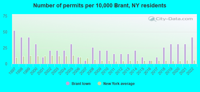
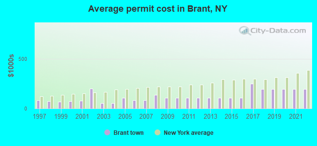
Single-family new house construction building permits:
- 2022: 8 buildings, average cost: $194,000
- 2021: 6 buildings, average cost: $194,000
- 2020: 6 buildings, average cost: $194,000
- 2019: 6 buildings, average cost: $194,000
- 2018: 5 buildings, average cost: $194,000
- 2017: 2 buildings, average cost: $250,000
- 2016: 1 building, cost: $107,500
- 2015: 2 buildings, average cost: $107,500
- 2014: 4 buildings, average cost: $107,500
- 2013: 3 buildings, average cost: $107,500
- 2012: 3 buildings, average cost: $107,500
- 2011: 3 buildings, average cost: $107,500
- 2010: 4 buildings, average cost: $107,500
- 2009: 4 buildings, average cost: $107,500
- 2008: 5 buildings, average cost: $138,000
- 2007: 1 building, cost: $84,500
- 2006: 2 buildings, average cost: $84,500
- 2005: 6 buildings, average cost: $107,500
- 2004: 4 buildings, average cost: $54,500
- 2003: 4 buildings, average cost: $54,500
- 2002: 4 buildings, average cost: $199,000
- 2001: 2 buildings, average cost: $80,000
- 2000: 6 buildings, average cost: $71,100
- 1999: 8 buildings, average cost: $68,400
- 1998: 8 buildings, average cost: $75,100
- 1997: 10 buildings, average cost: $85,200
| Here: | 4.4% |
| New York: | 4.4% |
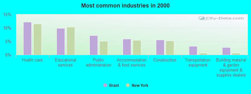
- Health care (12.3%)
- Educational services (9.9%)
- Public administration (7.2%)
- Accommodation & food services (5.9%)
- Construction (5.5%)
- Transportation equipment (3.3%)
- Building material & garden equipment & supplies dealers (2.8%)
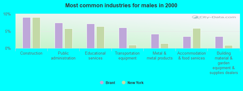
- Construction (9.0%)
- Public administration (7.4%)
- Educational services (7.2%)
- Transportation equipment (6.0%)
- Metal & metal products (4.2%)
- Accommodation & food services (3.5%)
- Building material & garden equipment & supplies dealers (3.5%)
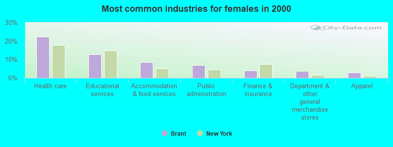
- Health care (22.4%)
- Educational services (12.7%)
- Accommodation & food services (8.4%)
- Public administration (7.0%)
- Finance & insurance (4.1%)
- Department & other general merchandise stores (3.6%)
- Apparel (2.9%)
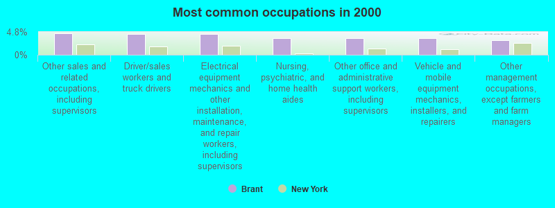
- Other sales and related occupations, including supervisors (4.5%)
- Driver/sales workers and truck drivers (4.4%)
- Electrical equipment mechanics and other installation, maintenance, and repair workers, including supervisors (4.4%)
- Nursing, psychiatric, and home health aides (3.5%)
- Other office and administrative support workers, including supervisors (3.5%)
- Vehicle and mobile equipment mechanics, installers, and repairers (3.4%)
- Other management occupations, except farmers and farm managers (3.1%)
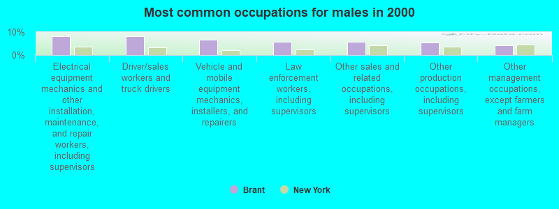
- Electrical equipment mechanics and other installation, maintenance, and repair workers, including supervisors (8.1%)
- Driver/sales workers and truck drivers (8.1%)
- Vehicle and mobile equipment mechanics, installers, and repairers (6.7%)
- Law enforcement workers, including supervisors (5.8%)
- Other sales and related occupations, including supervisors (5.8%)
- Other production occupations, including supervisors (5.6%)
- Other management occupations, except farmers and farm managers (4.2%)
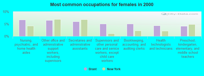
- Nursing, psychiatric, and home health aides (6.7%)
- Other office and administrative support workers, including supervisors (6.5%)
- Secretaries and administrative assistants (6.0%)
- Supervisors and other personal care and service workers, except child care workers (5.0%)
- Bookkeeping, accounting, and auditing clerks (5.0%)
- Health technologists and technicians (4.3%)
- Preschool, kindergarten, elementary, and middle school teachers (4.1%)
Average climate in Brant, New York
Based on data reported by over 4,000 weather stations


(lower is better)
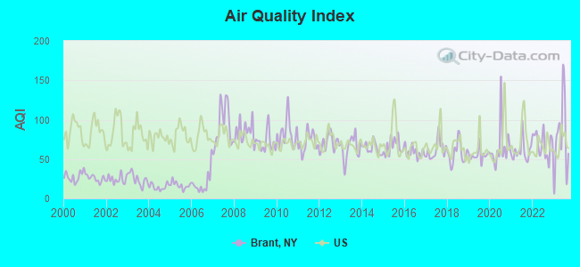
Air Quality Index (AQI) level in 2023 was 77.8. This is about average.
| City: | 77.8 |
| U.S.: | 72.6 |
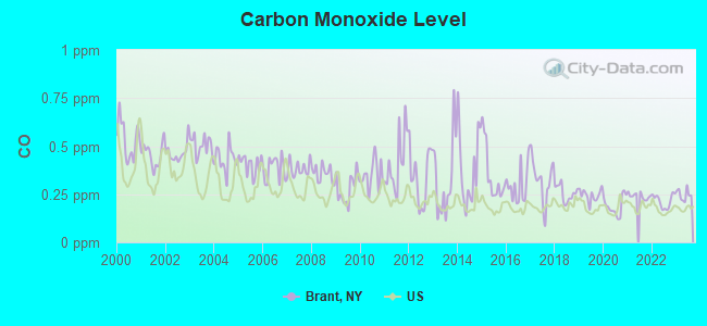
Carbon Monoxide (CO) [ppm] level in 2023 was 0.248. This is about average. Closest monitor was 22.8 miles away from the city center.
| City: | 0.248 |
| U.S.: | 0.251 |
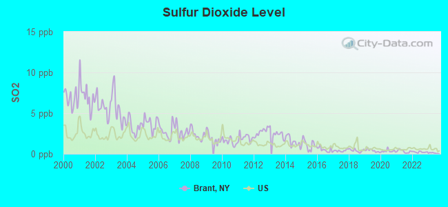
Sulfur Dioxide (SO2) [ppb] level in 2023 was 0.107. This is significantly better than average. Closest monitor was 9.4 miles away from the city center.
| City: | 0.107 |
| U.S.: | 1.515 |
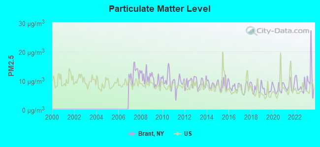
Particulate Matter (PM2.5) [µg/m3] level in 2023 was 10.6. This is worse than average. Closest monitor was 15.5 miles away from the city center.
| City: | 10.6 |
| U.S.: | 8.1 |
Tornado activity:
Brant-area historical tornado activity is near New York state average. It is 62% smaller than the overall U.S. average.
On 8/19/1970, a category F3 (max. wind speeds 158-206 mph) tornado 9.8 miles away from the Brant town center injured 3 people and caused between $50,000 and $500,000 in damages.
On 5/2/1983, a category F3 tornado 19.1 miles away from the town center killed 2 people and caused between $500,000 and $5,000,000 in damages.
Earthquake activity:
Brant-area historical earthquake activity is significantly above New York state average. It is 66% smaller than the overall U.S. average.On 9/25/1998 at 19:52:52, a magnitude 5.2 (4.8 MB, 4.3 MS, 5.2 LG, 4.5 MW, Depth: 3.1 mi, Class: Moderate, Intensity: VI - VII) earthquake occurred 103.2 miles away from the city center
On 1/31/1986 at 16:46:43, a magnitude 5.0 (5.0 MB) earthquake occurred 128.5 miles away from Brant center
On 8/23/2011 at 17:51:04, a magnitude 5.8 (5.8 MW, Depth: 3.7 mi) earthquake occurred 329.3 miles away from the city center
On 10/7/1983 at 10:18:46, a magnitude 5.3 (5.1 MB, 5.3 LG, 5.1 ML) earthquake occurred 254.7 miles away from the city center
On 4/20/2002 at 10:50:47, a magnitude 5.3 (5.3 ML, Depth: 3.0 mi) earthquake occurred 299.0 miles away from Brant center
On 4/20/2002 at 10:50:47, a magnitude 5.2 (5.2 MB, 4.2 MS, 5.2 MW, 5.0 MW) earthquake occurred 297.3 miles away from the city center
Magnitude types: regional Lg-wave magnitude (LG), body-wave magnitude (MB), local magnitude (ML), surface-wave magnitude (MS), moment magnitude (MW)
Natural disasters:
The number of natural disasters in Erie County (22) is greater than the US average (15).Major Disasters (Presidential) Declared: 11
Emergencies Declared: 10
Causes of natural disasters: Storms: 8, Floods: 7, Snowstorms: 6, Hurricanes: 2, Snows: 2, Winter Storms: 2, Blizzard: 1, Ice Storm: 1, Power Outage: 1, Wind: 1, Other: 2 (Note: some incidents may be assigned to more than one category).

Hospitals and medical centers near Brant:
- ABSOLUT CTR FOR NURSING AND REHAB EDEN L L C (Nursing Home, about 9 miles away; EDEN, NY)
- TLC HEALTH NETWORK Acute Care Hospitals (about 11 miles away; GOWANDA, NY)
- GOWANDA REHABILITATION AND NURSING CENTER (Nursing Home, about 12 miles away; GOWANDA, NY)
- ELDERWOOD HEALTH CARE AT LAKEWOOD (Nursing Home, about 15 miles away; HAMBURG, NY)
- SOUTHTOWNS DIALYSIS CENTER (Dialysis Facility, about 15 miles away; HAMBURG, NY)
Colleges/universities with over 2000 students nearest to Brant:
- SUNY at Fredonia (about 18 miles; Fredonia, NY; Full-time enrollment: 5,523)
- Bryant & Stratton College-Online (about 20 miles; Orchard Park, NY; FT enrollment: 2,212)
- Erie Community College (about 22 miles; Buffalo, NY; FT enrollment: 11,035)
- D'Youville College (about 23 miles; Buffalo, NY; FT enrollment: 2,398)
- Canisius College (about 25 miles; Buffalo, NY; FT enrollment: 4,376)
- Buffalo State SUNY (about 25 miles; Buffalo, NY; FT enrollment: 10,439)
- Medaille College (about 25 miles; Buffalo, NY; FT enrollment: 2,361)
Points of interest:
Notable locations in Brant: Awalds Berry Farm (A), Brant Volunteer Fire Company 1 (B). Display/hide their locations on the map
Churches in Brant include: Saint Anthony's Roman Catholic Church (A), Mount Zion Church (B), Our Lady of Mount Carmel Church (C), Holy Spirit Roman Catholic Church (D), Sacred Heart of Mary Church (E). Display/hide their locations on the map
Cemeteries: Brant Cemetery (1), Holy Cross Lutheran Cemetery (2), Huson Family Cemetery (3). Display/hide their locations on the map
Park in Brant: Evangola State Park (1). Display/hide its location on the map
Birthplace of: John Joseph Bernet - Railroad executive.
Drinking water stations with addresses in Brant and their reported violations in the past:
BRANT, TOWN OF (Address: Brant-North Collins Road , Population served: 465, Purch surface water):Past health violations:Past monitoring violations:
- MCL, Average - Between JAN-2012 and MAR-2012, Contaminant: TTHM. Follow-up actions: St Public Notif requested (JAN-04-2013), St Compliance achieved (JAN-04-2013), St Formal NOV issued (JAN-04-2013)
- Follow-up Or Routine LCR Tap M/R - In OCT-01-2011, Contaminant: Lead and Copper Rule. Follow-up actions: St Formal NOV issued (DEC-02-2013), St Public Notif requested (DEC-02-2013)
- One routine major monitoring violation
| This town: | 2.5 people |
| New York: | 2.6 people |
| This town: | 67.0% |
| Whole state: | 63.5% |
| This town: | 8.1% |
| Whole state: | 6.8% |
Likely homosexual households (counted as self-reported same-sex unmarried-partner households)
- Lesbian couples: 0.4% of all households
- Gay men: 0.2% of all households
| This town: | 6.4% |
| Whole state: | 14.6% |
| This town: | 3.8% |
| Whole state: | 7.4% |
For population 15 years and over in Brant:
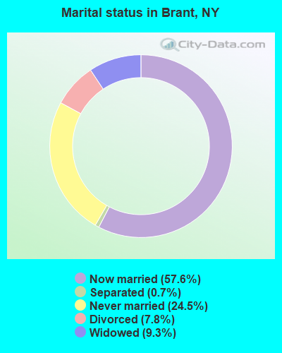
- Never married: 24.5%
- Now married: 57.6%
- Separated: 0.7%
- Widowed: 9.3%
- Divorced: 7.8%
For population 25 years and over in Brant:
- High school or higher: 81.0%
- Bachelor's degree or higher: 15.1%
- Graduate or professional degree: 5.0%
- Unemployed: 6.4%
- Mean travel time to work (commute): 29.8 minutes
| Here: | 10.6 |
| New York average: | 14.2 |
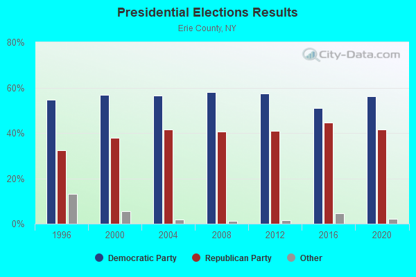
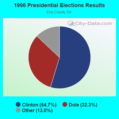
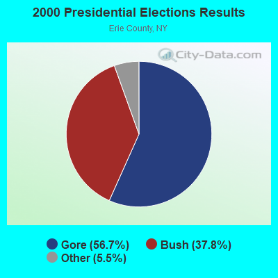
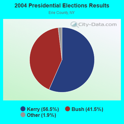
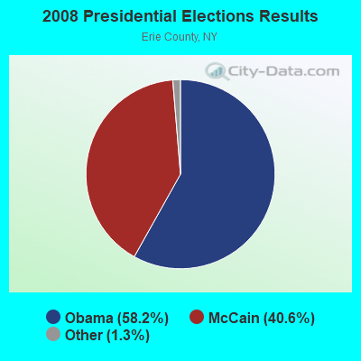
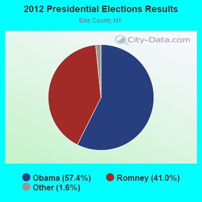
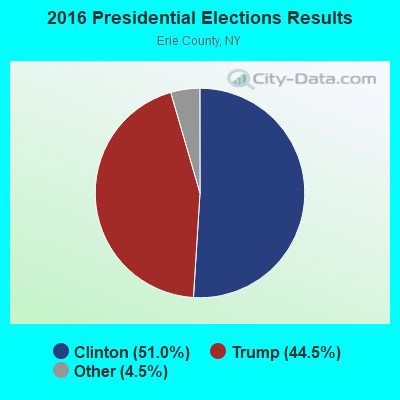

Graphs represent county-level data. Detailed 2008 Election Results
Religion statistics for Brant, NY (based on Erie County data)
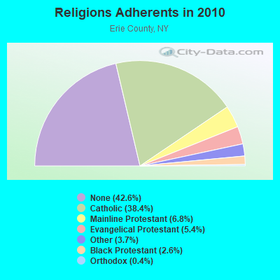
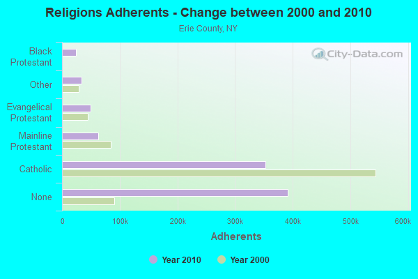
| Religion | Adherents | Congregations |
|---|---|---|
| Catholic | 352,894 | 111 |
| Mainline Protestant | 62,675 | 212 |
| Evangelical Protestant | 49,435 | 209 |
| Other | 34,076 | 79 |
| Black Protestant | 24,192 | 69 |
| Orthodox | 4,103 | 9 |
| None | 391,665 | - |
Food Environment Statistics:
| Erie County: | 2.59 / 10,000 pop. |
| New York: | 4.13 / 10,000 pop. |
| Erie County: | 0.05 / 10,000 pop. |
| New York: | 0.06 / 10,000 pop. |
| This county: | 1.37 / 10,000 pop. |
| State: | 0.92 / 10,000 pop. |
| Erie County: | 2.50 / 10,000 pop. |
| New York: | 1.68 / 10,000 pop. |
| This county: | 8.11 / 10,000 pop. |
| State: | 8.82 / 10,000 pop. |
| Erie County: | 9.8% |
| New York: | 8.2% |
| Erie County: | 26.9% |
| New York: | 23.8% |
| Here: | 13.4% |
| State: | 15.6% |
2.96% of this county's 2021 resident taxpayers lived in other counties in 2020 ($58,957 average adjusted gross income)
| Here: | 2.96% |
| New York average: | 5.29% |
0.01% of residents moved from foreign countries ($164 average AGI)
Erie County: 0.01% New York average: 0.01%
Top counties from which taxpayers relocated into this county between 2020 and 2021:
| from Niagara County, NY | |
| from Queens County, NY | |
| from Monroe County, NY |
3.42% of this county's 2020 resident taxpayers moved to other counties in 2021 ($64,893 average adjusted gross income)
| Here: | 3.42% |
| New York average: | 6.93% |
0.01% of residents moved to foreign countries ($150 average AGI)
Erie County: 0.01% New York average: 0.02%
Top counties to which taxpayers relocated from this county between 2020 and 2021:
| to Niagara County, NY | |
| to Monroe County, NY | |
| to Cattaraugus County, NY |
Strongest AM radio stations in Brant:
- WWKB (1520 AM; 50 kW; BUFFALO, NY; Owner: ENTERCOM BUFFALO LICENSE, LLC)
- WGR (550 AM; 5 kW; BUFFALO, NY; Owner: ENTERCOM BUFFALO LICENSE, LLC)
- WNED (970 AM; 5 kW; BUFFALO, NY)
- WHLD (1270 AM; 5 kW; NIAGARA FALLS, NY; Owner: CITADEL BROADCASTING COMPANY)
- WHAM (1180 AM; 50 kW; ROCHESTER, NY; Owner: CITICASTERS LICENSES, L.P.)
- WBEN (930 AM; 5 kW; BUFFALO, NY; Owner: ENTERCOM BUFFALO LICENSE, LLC)
- WTOR (770 AM; daytime; 9 kW; YOUNGSTOWN, NY; Owner: BIRACH BROADCASTING CORPORATION)
- WXRL (1300 AM; 5 kW; LANCASTER, NY; Owner: DOME BROADCASTING, INC.)
- WJJL (1440 AM; 5 kW; NIAGARA FALLS, NY; Owner: M.J. PHILLIPS COMMUNICATIONS, INC.)
- WGGO (1590 AM; 5 kW; SALAMANCA, NY; Owner: CATT COMMUNICATIONS, INC.)
- KDKA (1020 AM; 50 kW; PITTSBURGH, PA; Owner: INFINITY BROADCASTING OPERATIONS, INC.)
- WDOE (1410 AM; 1 kW; DUNKIRK, NY; Owner: CHADWICK BAY BROADCASTING CORPORATION)
- WMNY (1120 AM; daytime; 1 kW; BUFFALO, NY; Owner: CITADEL BROADCASTING COMPANY)
Strongest FM radio stations in Brant:
- WTSS (102.5 FM; BUFFALO, NY; Owner: ENTERCOM BUFFALO LICENSE, LLC)
- WNED-FM (94.5 FM; BUFFALO, NY; Owner: WESTERN NEW YORK PUBLIC B/C ASSOC.)
- WDCX (99.5 FM; BUFFALO, NY; Owner: KIMTRON, INC.)
- WBUF (92.9 FM; BUFFALO, NY; Owner: INFINITY RADIO OPERATIONS INC.)
- WGRF (96.9 FM; BUFFALO, NY; Owner: CITADEL BROADCASTING COMPANY)
- WFBF (89.9 FM; BUFFALO, NY; Owner: FAMILY STATIONS, INC.)
- WBKX (96.5 FM; FREDONIA, NY; Owner: CHADWICK BAY BROADCASTING CORPORATION)
- WBLK (93.7 FM; DEPEW, NY; Owner: INFINITY RADIO OPERATIONS INC.)
- WJYE (96.1 FM; BUFFALO, NY; Owner: INFINITY RADIO OPERATIONS INC.)
- WYRK (106.5 FM; BUFFALO, NY; Owner: INFINITY RADIO OPERATIONS INC.)
- WHTT-FM (104.1 FM; BUFFALO, NY; Owner: CITADEL BROADCASTING COMPANY)
- WNSA (107.7 FM; WETHERSFIELD TWNSHP, NY; Owner: ADELPHIA COMMUNICATIONS CORPORATION, DEBTOR-IN-POSSESSION)
- WNJA (89.7 FM; JAMESTOWN, NY; Owner: WESTERN NEW YORK PUBLIC B/CING ASSOC)
- WUBJ (88.1 FM; JAMESTOWN, NY; Owner: STATE UNIVERSITY OF NEW YORK)
- WKSE (98.5 FM; NIAGARA FALLS, NY; Owner: ENTERCOM BUFFALO LICENSE, LLC)
- WEDG (103.3 FM; BUFFALO, NY; Owner: CITADEL BROADCASTING COMPANY)
- W284AP (104.7 FM; BUFFALO, NY; Owner: FAMILY LIFE MINISTRIES, INC.)
TV broadcast stations around Brant:
- WNYB (Channel 26; JAMESTOWN, NY; Owner: FAITH BROADCASTING NETWORK, INC.)
- WKBW-TV (Channel 7; BUFFALO, NY; Owner: WKBW-TV LICENSE, INC.)
- WIVB-TV (Channel 4; BUFFALO, NY; Owner: WIVB BROADCASTING, LLC)
- WGRZ-TV (Channel 2; BUFFALO, NY; Owner: MULTIMEDIA ENTERTAINMENT, INC.)
- WNGS (Channel 67; SPRINGVILLE, NY; Owner: CAROLINE K. POWLEY D/B/A UNICORN/SPRINGVILLE)
- WUTV (Channel 29; BUFFALO, NY; Owner: WUTV LICENSEE, LLC)
- WNED-TV (Channel 17; BUFFALO, NY; Owner: WESTERN NY PUBLIC BROADCASTING ASSOC.)
- WNLO (Channel 23; BUFFALO, NY; Owner: WIVB BROADCASTING, LLC)
- WDTB-LP (Channel 39; HAMBURG, NY; Owner: WORD OF GOD FELLOWSHIP, INC.)
- WNYO-TV (Channel 49; BUFFALO, NY; Owner: NEW YORK TELEVISION, INC.)
- WFHW-LP (Channel 58; BUFFALO, NY; Owner: CITIZENS TELEVISION SYSTEM, INC.)
- WBXZ-LP (Channel 56; BUFFALO, NY; Owner: RENARD COMMUNICATIONS CORP.)
- WBNF-CA (Channel 15; BUFFALO, NY; Owner: FAITH BROADCASTING NETWORK, INC.)
- Brant, New York
- Fatal accident count45
- Vehicles involved in fatal accidents69
- Fatal accidents involving drunk persons:20
- Fatalities51
- Persons involved in fatal accidents118
- Pedestrians involved in fatal accidents2
- New York average
- Fatal accident count32394
- Vehicles involved in fatal accidents47293
- Fatal accidents involving drunk persons6877
- Fatalities35174
- Persons involved in fatal accidents80583
- Pedestrians involved in fatal accidents7674
- National Bridge Inventory (NBI) Statistics
- 24Number of bridges
- 157ft / 48.1mTotal length
- $32,149,000Total costs
- 104,109Total average daily traffic
- 1,234Total average daily truck traffic
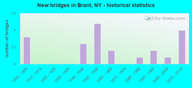
- New bridges - historical statistics
- 41900-1909
- 31940-1949
- 61950-1959
- 21960-1969
- 11980-1989
- 21990-1999
- 12000-2009
- 52010-2019
FCC Registered Cell Phone Towers:
2 (See the full list of FCC Registered Cell Phone Towers in Brant)FCC Registered Antenna Towers:
16 (See the full list of FCC Registered Antenna Towers)FCC Registered Microwave Towers:
2- ANGOLA, 633 Cain Rd (Lat: 42.608389 Lon: -79.063361), Overall height: 56.7 m, Call Sign: WMQ812,
Assigned Frequencies: 10618.1 MHz, Grant Date: 03/06/2001, Expiration Date: 02/01/2011, Cancellation Date: 04/15/2010, Certifier: Carol L Tacker, Registrant: At&t Mobility LLC, 1120 20th Street, Nw, Suite 1000, Washington, DC 20036, Phone: (202) 457-2055, Fax: (202) 457-3074, Email:
- SOUTH HILL, 10505 Manchester Rd (Lat: 42.593111 Lon: -78.667222), Overall height: 67.7 m, Call Sign: WLN322,
Assigned Frequencies: 2171.60 MHz, Grant Date: 03/06/2001, Expiration Date: 02/01/2011, Cancellation Date: 05/08/2008, Certifier: Carol L Tacker, Registrant: Cingular Wireless LLC, 5601 Legacy Drive Ms A-3, Plano, TX 75024, Phone: (469) 229-7506, Fax: (469) 229-7295, Email:
FCC Registered Amateur Radio Licenses:
1- Call Sign: KA2FEG, Grant Date: 05/28/1991, Expiration Date: 05/28/2001, Cancellation Date: 05/29/2003, Registrant: Walter R Constantine, Brant, NY 14027
2002 - 2018 National Fire Incident Reporting System (NFIRS) incidents
- Fire incident types reported to NFIRS in Brant, NY
- 6656.4%Structure Fires
- 3529.9%Outside Fires
- 1311.1%Mobile Property/Vehicle Fires
- 32.6%Other
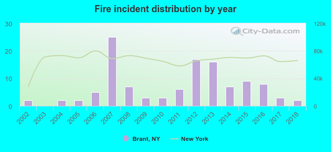 Based on the data from the years 2002 - 2018 the average number of fire incidents per year is 7. The highest number of fires - 25 took place in 2007, and the least - 0 in 2003. The data has a constant trend.
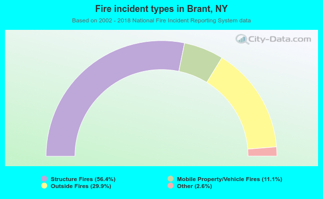 When looking into fire subcategories, the most reports belonged to: Structure Fires (56.4%), and Outside Fires (29.9%).
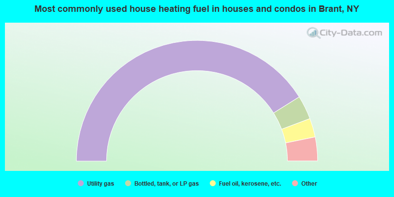
- 82.1%Utility gas
- 6.4%Bottled, tank, or LP gas
- 5.0%Fuel oil, kerosene, etc.
- 3.6%Wood
- 2.1%Electricity
- 0.7%Other fuel
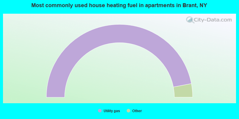
- 94.0%Utility gas
- 2.3%Bottled, tank, or LP gas
- 2.3%Electricity
- 1.5%Wood
Brant compared to New York state average:
- Median house value below state average.
- Unemployed percentage below state average.
- Black race population percentage significantly below state average.
- Hispanic race population percentage significantly below state average.
- Foreign-born population percentage significantly below state average.
- Renting percentage below state average.
- Length of stay since moving in significantly above state average.
- Number of rooms per house significantly below state average.
- House age significantly below state average.
- Number of college students below state average.
- Percentage of population with a bachelor's degree or higher below state average.

|
Total of 2 patent applications in 2008-2024.