Boulder, Utah
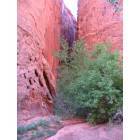
Boulder: Burr Trail Road, Boulder, UT
Boulder: Burr Trail Road, Boulder, UT
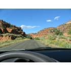
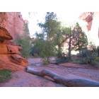
Boulder: Burr Trail Road, Boulder UT
- add
your
Submit your own pictures of this town and show them to the world
- OSM Map
- General Map
- Google Map
- MSN Map

Population change since 2000: +33.9%
| Males: 83 | |
| Females: 158 |
| Median resident age: | 43.5 years |
| Utah median age: | 32.1 years |
Zip code: 84716
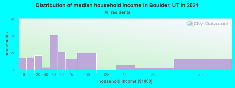
| Boulder: | $50,470 |
| UT: | $89,168 |
Estimated per capita income in 2022: $30,509 (it was $9,583 in 2000)
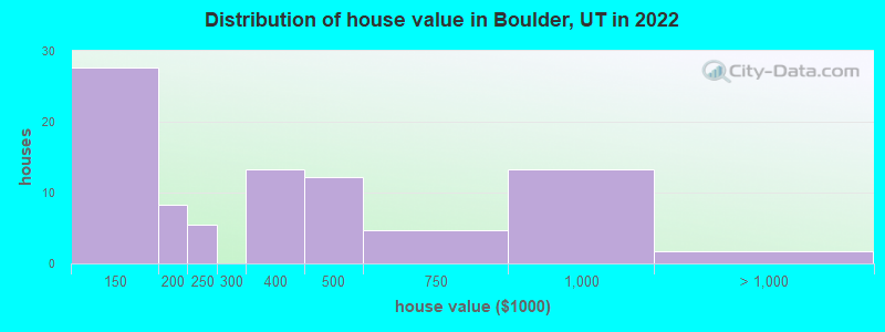
Estimated median house or condo value in 2022: $261,061 (it was $83,800 in 2000)
| Boulder: | $261,061 |
| UT: | $499,500 |
Mean prices in 2022: all housing units: $358,845; detached houses: $400,330; mobile homes: $167,249
Median gross rent in 2022: $809.
Detailed information about poverty and poor residents in Boulder, UT
Compare current foreclosures near your location:
| Photo | Address | Area | Beds / Baths | Price | Details |
|---|---|---|---|---|---|

|
#1
Bayberry Cir
Columbus, OH 43207
|
1,564 sq. feet
|
1 baths 3 beds |
$127,500
|
show details |

|
#2
S High St
Columbus, OH 43207
|
1,678 sq. feet
|
2 baths 4 beds |
$31,900
|
show details |

|
#3
E 21st Ave
Columbus, OH 43211
|
1,061 sq. feet
|
1 baths 3 beds |
$179,900
|
show details |

|
#4
Marshrun Dr
Grove City, OH 43123
|
2,036 sq. feet
|
2 baths 4 beds |
show details | |

|
#5
E Howard Rd
Columbus, OH 43207
|
1,056 sq. feet
|
1 baths 3 beds |
show details | |

|
#6
Hiawatha Park Dr
Columbus, OH 43211
|
1,278 sq. feet
|
1 baths 4 beds |
show details | |

|
#7
Brookstone Dr
Westerville, OH 43082
|
1,783 sq. feet
|
3 baths 3 beds |
show details | |

|
#8
N Roys Ave
Columbus, OH 43204
|
1,248 sq. feet
|
2 baths 3 beds |
show details | |

|
#9
Summertree Ln
Westerville, OH 43081
|
2,496 sq. feet
|
2 baths 3 beds |
show details | |

|
#10
Mink St SW
Pataskala, OH 43062
|
1,442 sq. feet
|
1 baths 3 beds |
show details |
| Photo | Address | Area | Beds / Baths | Price | Details |
|---|---|---|---|---|---|

|
#11
Armada Rd
Columbus, OH 43232
|
1,028 sq. feet
|
1 baths 4 beds |
show details | |

|
#12
Midland Ave
Columbus, OH 43223
|
1,518 sq. feet
|
1 baths 2 beds |
show details | |

|
#13
Grasmere Ave
Columbus, OH 43211
|
720 sq. feet
|
1 baths 2 beds |
show details | |

|
#14
High Free Pike
West Jefferson, OH 43162
|
1,216 sq. feet
|
2 baths 4 beds |
show details | |

|
#15
Wrexham Ave
Columbus, OH 43223
|
1,235 sq. feet
|
1 baths 3 beds |
show details | |

|
#16
Meadowbrook Dr
Columbus, OH 43207
|
1,752 sq. feet
|
2 baths 4 beds |
show details | |

|
#17
Chidley St
Galloway, OH 43119
|
1,502 sq. feet
|
1 baths 3 beds |
show details | |

|
#18
Kingsglen Dr
Grove City, OH 43123
|
1,635 sq. feet
|
2 baths 4 beds |
show details | |

|
#19
Fergus Rd
Grove City, OH 43123
|
3,312 sq. feet
|
2 baths 4 beds |
show details | |

|
#20
S Hague Ave
Columbus, OH 43204
|
979 sq. feet
|
1 baths 2 beds |
show details |
| Photo | Address | Area | Beds / Baths | Price | Details |
|---|---|---|---|---|---|

|
#21
E Welch Ave
Columbus, OH 43207
|
1,864 sq. feet
|
2 baths 4 beds |
show details | |

|
#22
Striebel Ct
Columbus, OH 43227
|
925 sq. feet
|
1 baths 3 beds |
show details | |

|
#23
S Richardson Ave
Columbus, OH 43204
|
1,520 sq. feet
|
2 baths 3 beds |
show details | |

|
#24
Lehner Rd
Columbus, OH 43224
|
1,628 sq. feet
|
2 baths 4 beds |
show details | |

|
#25
Derrer Rd -872
Columbus, OH 43204
|
1,667 sq. feet
|
2 baths 5 beds |
show details | |

|
#26
Fahlander Dr N
Columbus, OH 43229
|
1,338 sq. feet
|
2 baths 3 beds |
show details | |

|
#27
Sleeping Meadow Dr
New Albany, OH 43054
|
3,211 sq. feet
|
2 baths 4 beds |
show details | |

|
#28
Gladys Rd
Columbus, OH 43228
|
832 sq. feet
|
1 baths 3 beds |
show details | |

|
#29
N 18th St
Columbus, OH 43203
|
1,690 sq. feet
|
1 baths 4 beds |
show details | |

|
#30
Chester Rd
Columbus, OH 43221
|
3,300 sq. feet
|
4 baths 5 beds |
show details |
| Photo | Address | Area | Beds / Baths | Price | Details |
|---|---|---|---|---|---|

|
#31
Glenmate Ct
Columbus, OH 43223
|
1,050 sq. feet
|
1 baths 3 beds |
show details | |

|
#32
Ashgrove Dr
Grove City, OH 43123
|
1,772 sq. feet
|
2 baths 4 beds |
show details | |

|
#33
Hildreth Ave
Columbus, OH 43203
|
1,798 sq. feet
|
2 baths 4 beds |
show details | |

|
#34
Fairfield Ave
Columbus, OH 43203
|
984 sq. feet
|
1 baths 2 beds |
show details | |

|
#35
London Groveport Rd
Grove City, OH 43123
|
816 sq. feet
|
1 baths 2 beds |
show details | |

|
#36
Stoneybrook Blvd # 21a
Hilliard, OH 43026
|
1,231 sq. feet
|
2 baths 3 beds |
show details | |

|
#37
Scottwood Rd
Columbus, OH 43227
|
1,008 sq. feet
|
1 baths 3 beds |
show details | |

|
#38
Stoneybrook B 21a
Hilliard, OH 43026
|
1,031 sq. feet
|
1 baths 3 beds |
show details | |

|
#39
Casa Blvd
Grove City, OH 43123
|
1,002 sq. feet
|
1 baths 2 beds |
show details | |

|
#40
Wesson Dr
Columbus, OH 43232
|
1,200 sq. feet
|
1 baths 3 beds |
show details |
| Photo | Address | Area | Beds / Baths | Price | Details |
|---|---|---|---|---|---|

|
#41
Southbend Dr
Canal Winchester, OH 43110
|
3,394 sq. feet
|
2 baths 3 beds |
show details | |

|
#42
Nantucket Ave
Columbus, OH 43235
|
1,864 sq. feet
|
2 baths 3 beds |
show details | |

|
#43
Illinois Ave
Westerville, OH 43081
|
1,120 sq. feet
|
1 baths 3 beds |
show details | |

|
#44
Tea Party Pl
Columbus, OH 43207
|
1,176 sq. feet
|
2 baths 3 beds |
show details | |

|
#45
Ridgebury Dr
Hilliard, OH 43026
|
832 sq. feet
|
1 baths 2 beds |
show details | |

|
#46
Renford Ct
Powell, OH 43065
|
1,795 sq. feet
|
1 baths 3 beds |
show details | |

|
#47
Ratify Blvd
Columbus, OH 43207
|
1,356 sq. feet
|
2 baths 3 beds |
show details | |

|
#48
Royal Farm E
Blacklick, OH 43004
|
2,425 sq. feet
|
2 baths 3 beds |
show details | |

|
#49
Mango Ln
Hilliard, OH 43026
|
1,024 sq. feet
|
1 baths 2 beds |
show details | |

|
Check over 1 million property listings on Foreclosure.com!
|
browse all offers | |||


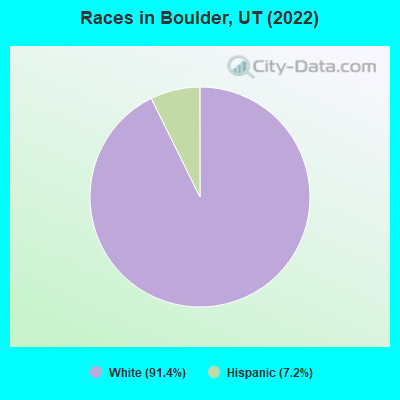
- 33191.4%White alone
- 267.2%Hispanic
 Recent articles from our blog. Our writers, many of them Ph.D. graduates or candidates, create easy-to-read articles on a wide variety of topics.

 | Moving to St. George - advice needed (40 replies) |
| Possible move to Cedar City, UT (61 replies) |
| Air quality and making friends as a progressise non-LDS 30year male? (6 replies) |
| Bought a home in St George.. (19 replies) |
| Help me decide on where to buy a vacation home in Utah (16 replies) |
| Months to not visit Zion, Bryce, Staircase (1 reply) |
Latest news from Boulder, UT collected exclusively by city-data.com from local newspapers, TV, and radio stations
Ancestries: English (32.2%), European (16.8%), German (7.7%), Scandinavian (4.9%), Irish (4.2%), Italian (3.5%).
Current Local Time: MST time zone
Land area: 20.9 square miles.
Population density: 12 people per square mile (very low).
6 residents are foreign born
| This town: | 1.7% |
| Utah: | 8.4% |
| Boulder town: | 0.7% ($550) |
| Utah: | 0.7% ($956) |
Nearest city with pop. 50,000+: Provo, UT  (161.0 miles , pop. 105,166).
Nearest city with pop. 200,000+: Las Vegas, NV (241.3 miles , pop. 478,434).
Nearest city with pop. 1,000,000+: Phoenix, AZ (306.2 miles , pop. 1,321,045).
Nearest cities:
), Latitude: 37.92 N, Longitude: 111.43 W
Area code: 435

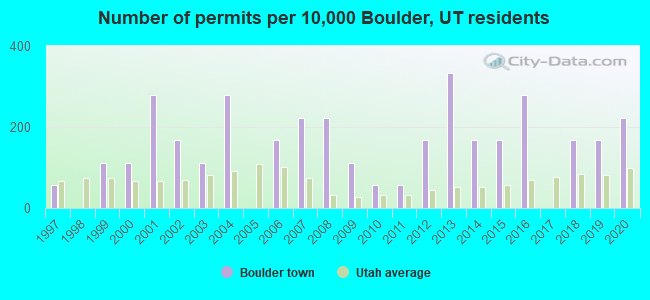
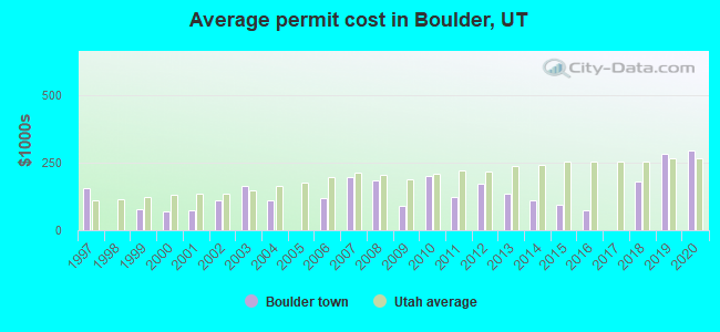
Single-family new house construction building permits:
- 2020: 4 buildings, average cost: $296,800
- 2019: 3 buildings, average cost: $282,800
- 2018: 3 buildings, average cost: $181,500
- 2016: 5 buildings, average cost: $72,700
- 2015: 3 buildings, average cost: $96,300
- 2014: 3 buildings, average cost: $112,300
- 2013: 6 buildings, average cost: $134,000
- 2012: 3 buildings, average cost: $171,700
- 2011: 1 building, cost: $125,000
- 2010: 1 building, cost: $200,000
- 2009: 2 buildings, average cost: $88,500
- 2008: 4 buildings, average cost: $185,000
- 2007: 4 buildings, average cost: $198,300
- 2006: 3 buildings, average cost: $121,000
- 2004: 5 buildings, average cost: $110,000
- 2003: 2 buildings, average cost: $165,000
- 2002: 3 buildings, average cost: $111,700
- 2001: 5 buildings, average cost: $72,000
- 2000: 2 buildings, average cost: $70,000
- 1999: 2 buildings, average cost: $78,500
- 1997: 1 building, cost: $156,800
| Here: | 9.3% |
| Utah: | 2.5% |
- Accommodation & food services (42.9%)
- Food & beverage stores (16.9%)
- Agriculture, forestry, fishing & hunting (13.0%)
- Construction (13.0%)
- Health care (3.9%)
- Social assistance (3.9%)
- Utilities (2.6%)
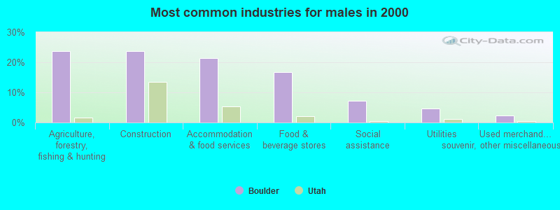
- Agriculture, forestry, fishing & hunting (23.8%)
- Construction (23.8%)
- Accommodation & food services (21.4%)
- Food & beverage stores (16.7%)
- Social assistance (7.1%)
- Utilities (4.8%)
- Used merchandise, gift, novelty, souvenir, other miscellaneous stores (2.4%)
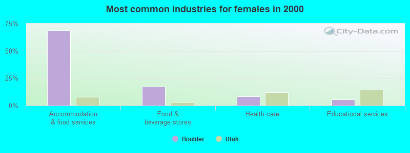
- Accommodation & food services (68.6%)
- Food & beverage stores (17.1%)
- Health care (8.6%)
- Educational services (5.7%)
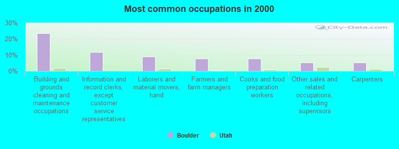
- Building and grounds cleaning and maintenance occupations (23.4%)
- Information and record clerks, except customer service representatives (11.7%)
- Laborers and material movers, hand (9.1%)
- Farmers and farm managers (7.8%)
- Cooks and food preparation workers (7.8%)
- Other sales and related occupations, including supervisors (5.2%)
- Carpenters (5.2%)
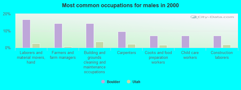
- Laborers and material movers, hand (16.7%)
- Farmers and farm managers (14.3%)
- Building and grounds cleaning and maintenance occupations (14.3%)
- Carpenters (9.5%)
- Cooks and food preparation workers (7.1%)
- Child care workers (7.1%)
- Construction laborers (7.1%)
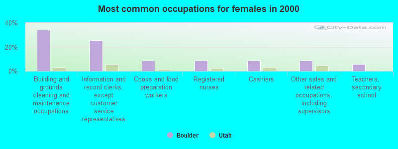
- Building and grounds cleaning and maintenance occupations (34.3%)
- Information and record clerks, except customer service representatives (25.7%)
- Cooks and food preparation workers (8.6%)
- Registered nurses (8.6%)
- Cashiers (8.6%)
- Other sales and related occupations, including supervisors (8.6%)
- Teachers, secondary school (5.7%)
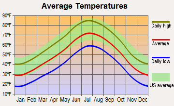
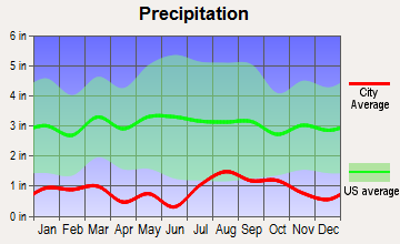
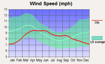
Average climate in Boulder, Utah
Based on data reported by over 4,000 weather stations


Earthquake activity:
Boulder-area historical earthquake activity is significantly above Utah state average. It is 2702% greater than the overall U.S. average.On 10/3/1915 at 06:52:48, a magnitude 7.6 (7.6 UK, Class: Major, Intensity: VIII - XII) earthquake occurred 370.9 miles away from the city center
On 6/28/1992 at 11:57:34, a magnitude 7.6 (6.2 MB, 7.6 MS, 7.3 MW, Depth: 0.7 mi) earthquake occurred 385.2 miles away from Boulder center, causing 3 deaths (1 shaking deaths, 2 other deaths) and 400 injuries, causing $100,000,000 total damage and $40,000,000 insured losses
On 10/16/1999 at 09:46:44, a magnitude 7.4 (6.3 MB, 7.4 MS, 7.2 MW, 7.3 ML) earthquake occurred 365.6 miles away from the city center
On 12/21/1932 at 06:10:09, a magnitude 7.2 (7.2 UK) earthquake occurred 364.0 miles away from the city center
On 8/18/1959 at 06:37:13, a magnitude 7.7 (7.7 UK) earthquake occurred 461.1 miles away from Boulder center, causing $26,000,000 total damage
On 7/21/1952 at 11:52:14, a magnitude 7.7 (7.7 UK) earthquake occurred 467.1 miles away from the city center, causing $50,000,000 total damage
Magnitude types: body-wave magnitude (MB), local magnitude (ML), surface-wave magnitude (MS), moment magnitude (MW)
Natural disasters:
The number of natural disasters in Garfield County (5) is a lot smaller than the US average (15).Major Disasters (Presidential) Declared: 2
Emergencies Declared: 2
Causes of natural disasters: Floods: 2, Drought: 1, Hurricane: 1, Landslide: 1, Storm: 1, Winter Storm: 1, Other: 1 (Note: some incidents may be assigned to more than one category).

Colleges/universities with over 2000 students nearest to Boulder:
- Southern Utah University (about 92 miles; Cedar City, UT; Full-time enrollment: 6,522)
- Snow College (about 100 miles; Ephraim, UT; FT enrollment: 3,224)
- Dixie State University (about 131 miles; Saint George, UT; FT enrollment: 6,485)
- Brigham Young University-Provo (about 162 miles; Provo, UT; FT enrollment: 33,525)
- Utah Valley University (about 164 miles; Orem, UT; FT enrollment: 24,403)
- Colorado Mesa University (about 176 miles; Grand Junction, CO; FT enrollment: 7,671)
- Northern Arizona University (about 191 miles; Flagstaff, AZ; FT enrollment: 22,494)
Public elementary/middle school in Boulder:
- BOULDER SCHOOL (Students: 491, Location: 50 SCH HOUSE LN, Grades: KG-6)
Points of interest:
Notable locations in Boulder: Garkane Hydroelectric Plant (A), Boulder Volunteer Fire Department (B). Display/hide their locations on the map
Church in Boulder: The Church of Jesus Christ of Latter Day Saints (A). Display/hide its location on the map
Cemetery: Boulder Cemetery (1). Display/hide its location on the map
Park in Boulder: Anasazi Historical Site (1). Display/hide its location on the map
Tourist attractions: Anasazi Indian Museum (460 North State Highway 12) (1), Escalante Canyon Outfitters (Tours & Charters; 840 West Highway 12) (2). Display/hide their approximate locations on the map
Hotels: Boulder Mountain Lodge (20 North State Highway 12) (1), Circle Cliffs Motel (205 North State Highway 12) (2). Display/hide their approximate locations on the map
Drinking water stations with addresses in Boulder and their reported violations in the past:
BOULDER FARMSTEAD WATER CO (Population served: 277, Groundwater):Past monitoring violations:BOULDER MOUNTAIN LODGE (Population served: 30, Groundwater):
- Monitoring and Reporting (DBP) - Between JUL-2009 and SEP-2009, Contaminant: Chlorine. Follow-up actions: St Public Notif requested (DEC-17-2009), St Violation/Reminder Notice (DEC-17-2009), St Compliance achieved (FEB-15-2010)
- Monitoring and Reporting (DBP) - Between JUL-2007 and SEP-2007, Contaminant: Chlorine. Follow-up actions: St Compliance achieved (JUN-11-2008)
- 3 regular monitoring violations
Past monitoring violations:
- Monitoring, Source Water (GWR) - In FEB-01-2013, Contaminant: E. COLI. Follow-up actions: St Formal NOV issued (MAR-09-2013), St Public Notif requested (MAR-09-2013)
- Monitoring, Repeat Major (TCR) - In JAN-2013, Contaminant: Coliform (TCR). Follow-up actions: St Formal NOV issued (MAR-09-2013), St Public Notif requested (MAR-09-2013)
- Monitoring, Source Water (GWR) - In AUG-01-2010, Contaminant: E. COLI. Follow-up actions: St Public Notif requested (OCT-14-2010), St Compliance achieved (OCT-14-2010), St Formal NOV issued (OCT-14-2010)
- Monitoring, Repeat Major (TCR) - In AUG-2010, Contaminant: Coliform (TCR)
- Monitoring, Repeat Major (TCR) - In JUL-2005, Contaminant: Coliform (TCR). Follow-up actions: St Violation/Reminder Notice (2 times from NOV-10-2005 to NOV-10-2005), St Public Notif requested (2 times from NOV-10-2005 to NOV-10-2005), St Compliance achieved (JAN-01-2010)
- 3 routine major monitoring violations
- One minor monitoring violation
- 2 regular monitoring violations
| This town: | 2.3 people |
| Utah: | 3.1 people |
| This town: | 57.6% |
| Whole state: | 75.2% |
| This town: | 10.1% |
| Whole state: | 4.6% |
Likely homosexual households (counted as self-reported same-sex unmarried-partner households)
- Lesbian couples: 0.0% of all households
- Gay men: 2.0% of all households
For population 15 years and over in Boulder:
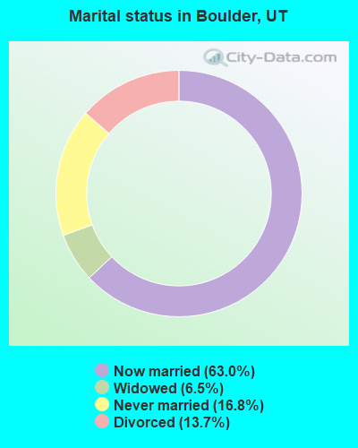
- Never married: 16.8%
- Now married: 63.0%
- Separated: 0.0%
- Widowed: 6.5%
- Divorced: 13.7%
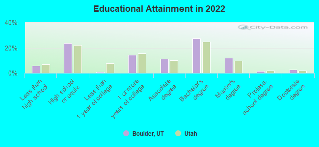
For population 25 years and over in Boulder:
- High school or higher: 93.2%
- Bachelor's degree or higher: 40.9%
- Graduate or professional degree: 14.8%
- Unemployed: 14.4%
- Mean travel time to work (commute): 9.7 minutes
| Here: | 9.0 |
| Utah average: | 10.9 |
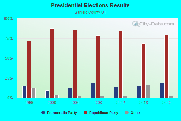
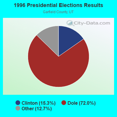
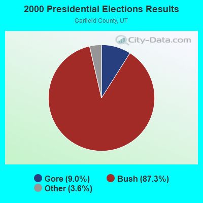
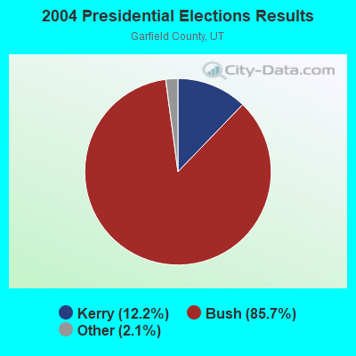
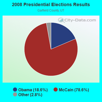
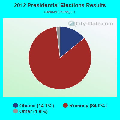
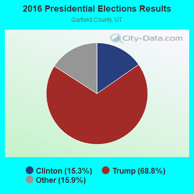
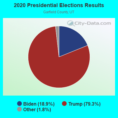
Graphs represent county-level data. Detailed 2008 Election Results
Religion statistics for Boulder, UT (based on Garfield County data)
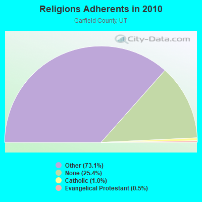
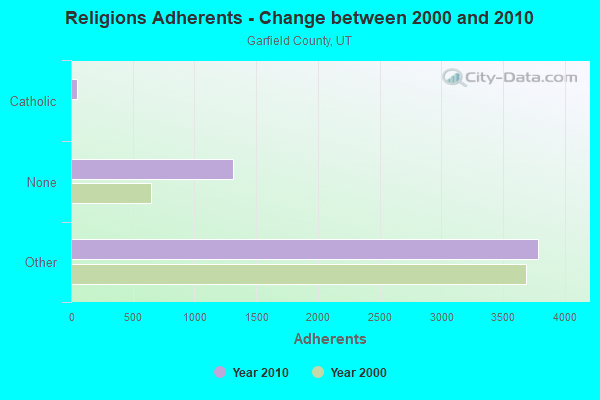
| Religion | Adherents | Congregations |
|---|---|---|
| Other | 3,781 | 15 |
| Catholic | 50 | 1 |
| Evangelical Protestant | 25 | 1 |
| None | 1,316 | - |
Food Environment Statistics:
| Garfield County: | 2.21 / 10,000 pop. |
| Utah: | 1.37 / 10,000 pop. |
| Garfield County: | 2.21 / 10,000 pop. |
| Utah: | 0.41 / 10,000 pop. |
| Garfield County: | 17.67 / 10,000 pop. |
| State: | 2.82 / 10,000 pop. |
| Here: | 15.46 / 10,000 pop. |
| State: | 5.09 / 10,000 pop. |
| This county: | 8.4% |
| Utah: | 6.3% |
| Garfield County: | 24.2% |
| Utah: | 23.6% |
Health and Nutrition:
| This city: | 48.7% |
| Utah: | 48.9% |
| Boulder: | 43.4% |
| Utah: | 47.0% |
| Boulder: | 29.9 |
| Utah: | 28.4 |
| Boulder: | 23.0% |
| Utah: | 21.0% |
| This city: | 21.4% |
| Utah: | 10.3% |
| Boulder: | 6.7 |
| Utah: | 6.8 |
| Boulder: | 37.7% |
| State: | 31.9% |
| This city: | 53.0% |
| Utah: | 57.4% |
| This city: | 77.4% |
| Utah: | 80.1% |
More about Health and Nutrition of Boulder, UT Residents
| Local government employment and payroll (March 2022) | |||||
| Function | Full-time employees | Monthly full-time payroll | Average yearly full-time wage | Part-time employees | Monthly part-time payroll |
|---|---|---|---|---|---|
| Solid Waste Management | 0 | $0 | 1 | $204 | |
| Parks and Recreation | 0 | $0 | 1 | $477 | |
| Other Government Administration | 0 | $0 | 4 | $1,661 | |
| Totals for Government | 0 | $0 | 6 | $2,342 | |
Boulder government finances - Expenditure in 2017 (per resident):
- Construction - Natural Resources - Other: $4,000 ($16.60)
Miscellaneous Commercial Activities - Other: $1,000 ($4.15)
- Current Operations - Central Staff Services: $32,000 ($132.78)
General - Other: $12,000 ($49.79)
General Public Buildings: $9,000 ($37.34)
Judicial and Legal Services: $9,000 ($37.34)
Local Fire Protection: $9,000 ($37.34)
Parks and Recreation: $8,000 ($33.20)
Natural Resources - Other: $8,000 ($33.20)
Solid Waste Management: $6,000 ($24.90)
Financial Administration: $2,000 ($8.30)
Libraries: $1,000 ($4.15)
- General - Interest on Debt: $8,000 ($33.20)
- Intergovernmental to Local - Other - Regular Highways: $172,000 ($713.69)
Other - Protective Inspection and Regulations: $1,000 ($4.15)
- Other Capital Outlay - Natural Resources - Other: $3,000 ($12.45)
- Total Salaries and Wages: $10,000 ($41.49)
Boulder government finances - Revenue in 2017 (per resident):
- Charges - Solid Waste Management: $1,000 ($4.15)
- Local Intergovernmental - General Local Government Support: $1,000 ($4.15)
- Miscellaneous - Donations From Private Sources: $2,000 ($8.30)
Rents: $1,000 ($4.15)
Interest Earnings: $1,000 ($4.15)
- State Intergovernmental - Highways: $27,000 ($112.03)
Other: $19,000 ($78.84)
- Tax - General Sales and Gross Receipts: $90,000 ($373.44)
Property: $6,000 ($24.90)
Public Utilities Sales: $2,000 ($8.30)
Occupation and Business License - Other: $1,000 ($4.15)
Boulder government finances - Debt in 2017 (per resident):
- Long Term Debt - Beginning Outstanding - Unspecified Public Purpose: $190,000 ($788.38)
Outstanding Unspecified Public Purpose: $182,000 ($755.19)
Retired Unspecified Public Purpose: $8,000 ($33.20)
Boulder government finances - Cash and Securities in 2017 (per resident):
- Other Funds - Cash and Securities: $298,000 ($1236.51)
- Sinking Funds - Cash and Securities: $8,000 ($33.20)
Strongest AM radio stations in Boulder:
- KTNN (660 AM; 50 kW; WINDOW ROCK, AZ; Owner: THE NAVAJO NATION)
- KMTI (650 AM; 10 kW; MANTI, UT; Owner: SANPETE COUNTY BROADCASTING COMPANY)
- KALL (700 AM; 50 kW; NORTH SALT LAKE CITY, UT; Owner: CITICASTERS LICENSES, L.P.)
- KNZZ (1100 AM; 50 kW; GRAND JUNCTION, CO; Owner: M B C GRAND BROADCASTING, INC.)
- KIQN (1010 AM; 50 kW; TOOELE, UT)
- KNNZ (940 AM; 10 kW; CEDAR CITY, UT; Owner: MB MEDIA GROUP, INC.)
- KDWN (720 AM; 50 kW; LAS VEGAS, NV; Owner: RADIO NEVADA CORP.)
- KXNT (840 AM; 50 kW; NORTH LAS VEGAS, NV; Owner: INFINITY RADIO OPERATIONS INC.)
- KHAC (880 AM; 43 kW; TSE BONITO, NM; Owner: WESTERN INDIAN MINISTRIES, INC.)
- KSVC (980 AM; 5 kW; RICHFIELD, UT; Owner: MID-UTAH RADIO, INC.)
- KSL (1160 AM; 50 kW; SALT LAKE CITY, UT; Owner: BONNEVILLE HOLDING COMPANY)
- KMIA (710 AM; 50 kW; BLACK CANYON CITY, AZ; Owner: ENTRAVISION HOLDINGS, LLC)
- KOAL (750 AM; 10 kW; PRICE, UT; Owner: EASTERN UTAH BROADCASTING CO.)
Strongest FM radio stations in Boulder:
- K282AC (104.3 FM; RURAL GARFIELD COUNT, UT; Owner: GARFIELD COUNTY)
- K255AD (98.9 FM; RURAL GARFIELD, ETC., UT; Owner: GARFIELD COUNTY)
- KCYQ (93.7 FM; RICHFIELD, UT; Owner: MID-UTAH RADIO, INC.)
TV broadcast stations around Boulder:
- K08II (Channel 8; BOULDER, UT; Owner: GARFIELD COUNTY)
- K10JG (Channel 10; BOULDER, UT; Owner: GARFIELD COUNTY)
- K12JR (Channel 12; BOULDER, UT; Owner: GARFIELD COUNTY)
- K18CG (Channel 18; BOULDER, UT; Owner: UNIVERSITY OF UTAH)
Boulder fatal accident list:
Dec 29, 2002 05:00 PM, Sr-12, Lat: 37.901267, Lon: -111.425086, Vehicles: 1, Persons: 2, Fatalities: 1
Sep 12, 1999 03:00 PM, Sr-12, Lat: 37.901267, Lon: -111.425086, Vehicles: 1, Persons: 1, Fatalities: 1
Aug 13, 1998 05:30 PM, Burrtrail, Vehicles: 1, Persons: 1, Fatalities: 1
Sep 13, 1998 04:00 PM, Sr-12, Vehicles: 1, Persons: 3, Fatalities: 1
- National Bridge Inventory (NBI) Statistics
- 3Number of bridges
- 7ft / 2.2mTotal length
- 1,181Total average daily traffic
- 118Total average daily truck traffic
- 1,489Total future (year 2040) average daily traffic
FCC Registered Broadcast Land Mobile Towers:
5- Spectacle Reservoir 19 Km Nw (Lat: 38.078861 Lon: -111.507667), Type: Pole, Structure height: 14 m, Call Sign: KNNF492,
Assigned Frequencies: 456.025 MHz, Grant Date: 01/10/1996, Expiration Date: 01/10/2001, Cancellation Date: 04/15/2001, Certifier: Mike Avant, Registrant: Garkane Power Association Inc, 1802 S 175 E, Kanab, UT 84741, Phone: (801) 644-5026, Fax: (801) 644-8120
- 6 Mi N (Lat: 37.980528 Lon: -111.467389), Call Sign: KQY74,
Assigned Frequencies: 158.220 MHz, Grant Date: 01/08/2022, Expiration Date: 02/19/2032, Registrant: Garkane Energy Cooperative, Inc., 1802 South Highway 89a, Kanab, UT 84741, Phone: (435) 339-0658, Fax: (435) 339-0658, Email:
- Spectacle Reservoir 19 Km Nw (Lat: 38.078861 Lon: -111.507667), Type: Building, Structure height: 14 m, Call Sign: WPSI939,
Assigned Frequencies: 456.025 MHz, Grant Date: 04/20/2021, Expiration Date: 05/14/2031, Certifier: Mike Avant, Registrant: Garkane Energy Cooperative, Inc., 1802 South Highway 89a, Kanab, UT 84741, Phone: (435) 339-0658, Fax: (435) 339-0658, Email:
- Lat: 37.755250 Lon: -111.874889, Call Sign: WQAP407,
Assigned Frequencies: 452.500 MHz, 457.500 MHz, Grant Date: 06/12/2014, Expiration Date: 07/14/2024, Certifier: Jon Hunter, Registrant: Cara Enterprises Inc, Las Vegas, NV 89140-0124, Phone: (702) 838-9728, Fax: (702) 363-4607, Email:
- Lat: 38.075806 Lon: -111.073472, Call Sign: WQVT351,
Assigned Frequencies: 157.725 MHz, Grant Date: 05/05/2015, Expiration Date: 05/05/2025, Certifier: Myron Moore, Registrant: Cara Enterprises Inc, Las Vegas, NV 89140-0124, Phone: (702) 838-9728, Fax: (702) 363-4607, Email:
FCC Registered Microwave Towers:
5- Mt. Pennell, 55.2 Km East Of (Lat: 37.950639 Lon: -110.796944), Type: Pole, Structure height: 7.3 m, Call Sign: WQHH811,
Assigned Frequencies: 6271.36 MHz, 6271.36 MHz, 6330.66 MHz, 6330.66 MHz, 6271.36 MHz, 6271.36 MHz, 6330.66 MHz, 6330.66 MHz, 6271.36 MHz, 6271.36 MHz... (+6 more), Grant Date: 08/22/2017, Expiration Date: 07/31/2027, Certifier: James Mccown, Registrant: Intelpath, Hindsdale, IL 60522, Phone: (312) 841-9188, Email:
- Boulder Elementary, Alongside I-12 (Lat: 37.907944 Lon: -111.421111), Type: Building, Structure height: 6.1 m, Call Sign: WQSF672,
Assigned Frequencies: 11565.0 MHz, 11565.0 MHz, Grant Date: 09/13/2013, Expiration Date: 09/13/2023, Cancellation Date: 08/14/2023, Certifier: Jeff Hodges, Registrant: Intelpath, 16 W 575 79th St., #102, Willowbrook, IL 60527, Phone: (312) 841-9188, Email:
- BOULDER, 155e 300n (Lat: 37.908528 Lon: -111.421944), Type: Mtower, Structure height: 4.6 m, Call Sign: WROW915,
Assigned Frequencies: 5945.20 MHz, 6595.00 MHz, 6625.00 MHz, 5945.20 MHz, 6595.00 MHz, 6625.00 MHz, 5945.20 MHz, 6595.00 MHz, 6625.00 MHz, 5945.20 MHz... (+40 more), Grant Date: 12/22/2021, Expiration Date: 12/22/2031, Cancellation Date: 01/16/2024, Certifier: Dale Wilson, Registrant: Contractor, 1939 N Placita La Zarca, Tucson, AZ 85745, Phone: (520) 743-7205, Email:
- THOMPSON RID, 280 E. Burr Trail Rd (Lat: 37.898028 Lon: -111.419611), Type: Mast, Structure height: 18.3 m, Call Sign: WRUX774,
Assigned Frequencies: 6595.00 MHz, 6625.00 MHz, 6595.00 MHz, 6625.00 MHz, 6595.00 MHz, 6625.00 MHz, 6655.00 MHz, 6685.00 MHz, 6655.00 MHz, 6685.00 MHz... (+34 more), Grant Date: 10/17/2022, Expiration Date: 10/17/2032, Certifier: Dale Wilson, Registrant: Contractor, 1939 N Placita La Zarca, Tucson, AZ 85745, Phone: (520) 743-7205, Email:
- BOULDER, 2 Blocks South Of Po (Lat: 37.908306 Lon: -111.421833), Overall height: 9.1 m, Call Sign: WAS467,
Assigned Frequencies: 11325.0 MHz, Grant Date: 12/29/2020, Expiration Date: 02/01/2031, Registrant: Blooston, Mordkofsky, Dickens, Duffy & Prendergast, LLP, 2120 L St Nw Ste 300, Washington, DC 20037-1563, Phone: (202) 828-5519, Fax: (202) 828-5568, Email:
FCC Registered Amateur Radio Licenses:
6- Call Sign: N7LTX, Licensee ID: L01447864, Grant Date: 08/23/2019, Expiration Date: 08/23/2029, Certifier: John M Veranth, Registrant: John M Veranth, 750 West Hwy 12, Boulder, UT 84716
- Call Sign: KE7ZDV, Licensee ID: L01455209, Grant Date: 10/23/2018, Expiration Date: 12/29/2028, Certifier: Eric J Feiler, Registrant: Eric J Feiler, Boulder, UT 84716
- Call Sign: KF7WQM, Licensee ID: L01721907, Grant Date: 07/11/2012, Expiration Date: 07/11/2022, Certifier: Matthew J Cochran, Registrant: Matthew J Cochran, Boulder, UT 84716
- Call Sign: KF7WQN, Licensee ID: L01721908, Grant Date: 07/11/2012, Expiration Date: 07/11/2022, Certifier: Julie D Ketchum, Registrant: Julie D Ketchum, Boulder, UT 84716
- Call Sign: KF7WQO, Licensee ID: L01721909, Grant Date: 07/11/2012, Expiration Date: 07/11/2022, Certifier: Landon C Ketchum, Registrant: Landon C Ketchum, Boulder, UT 84716
- Call Sign: KG7CTI, Licensee ID: L01781394, Grant Date: 04/16/2013, Expiration Date: 04/16/2023, Certifier: Scott G Brodie, Registrant: Scott G Brodie, Boulder, UT 84716
FAA Registered Aircraft:
1- Aircraft: AMERICAN CHAMPION AIRCRAFT 8GCBC (Category: Land, Seats: 3, Weight: Up to 12,499 Pounds), Engine: LYCOMING O-360 SERIES (180 HP) (Reciprocating)
N-Number: 221PM, N221PM, N-221PM, Serial Number: 451-2003, Year manufactured: 2004, Airworthiness Date: 01/19/2004, Certificate Issue Date: 03/20/2018
Registrant (Individual): Thomas F Hester, Po Box 1359, Boulder, UT 84716
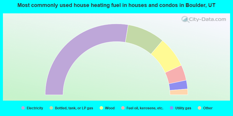
- 56.7%Electricity
- 17.5%Bottled, tank, or LP gas
- 14.4%Wood
- 7.2%Fuel oil, kerosene, etc.
- 4.1%Utility gas
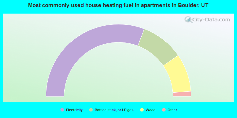
- 63.0%Electricity
- 19.6%Bottled, tank, or LP gas
- 17.4%Wood
Boulder compared to Utah state average:
- Median household income below state average.
- Median house value below state average.
- Black race population percentage significantly below state average.
- Median age significantly above state average.
- Foreign-born population percentage significantly below state average.
- Length of stay since moving in significantly above state average.
- Number of rooms per house below state average.
- Number of college students significantly below state average.
- Percentage of population with a bachelor's degree or higher above state average.
Boulder on our top lists:
- #48 on the list of "Top 100 cities with strongest arts, entertainment, recreation, accommodation and food services industries"
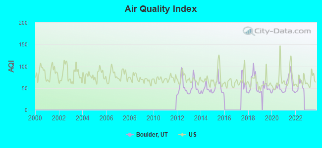
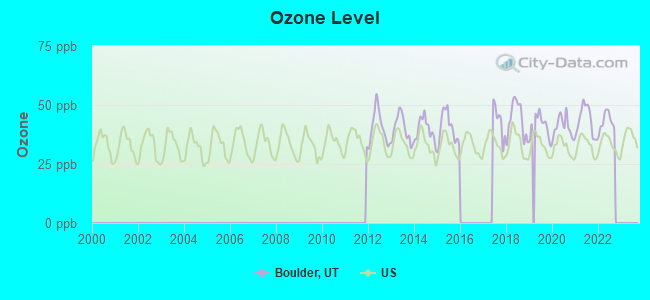
- #37 on the list of "Top 101 counties with the highest Ozone (1-hour) air pollution readings in 2012 (ppm)"