Boling-Iago, Texas
Submit your own pictures of this place and show them to the world
- OSM Map
- General Map
- Google Map
- MSN Map
| Males: 642 | |
| Females: 615 |
| Median resident age: | 32.9 years |
| Texas median age: | 32.3 years |
Zip codes: 77420.
| Boling-Iago: | $51,749 |
| TX: | $72,284 |
Estimated per capita income in 2022: $25,451 (it was $13,261 in 2000)
Boling-Iago CDP income, earnings, and wages data
Estimated median house or condo value in 2022: $141,634 (it was $40,800 in 2000)
| Boling-Iago: | $141,634 |
| TX: | $275,400 |
Detailed information about poverty and poor residents in Boling-Iago, TX


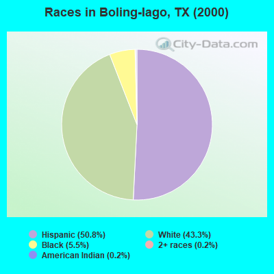
- 64650.8%Hispanic
- 55043.3%White alone
- 705.5%Black alone
- 20.2%American Indian alone
- 30.2%Two or more races
Races in Boling-Iago detailed stats: ancestries, foreign born residents, place of birth
 Recent articles from our blog. Our writers, many of them Ph.D. graduates or candidates, create easy-to-read articles on a wide variety of topics.

Ancestries: German (11.3%), United States (8.7%), Czech (6.8%), English (5.7%), Irish (5.1%), French (1.7%).
Current Local Time: CST time zone
Land area: 6.97 square miles.
Population density: 180 people per square mile (very low).
268 residents are foreign born (21.1% Latin America).
| This place: | 21.1% |
| Texas: | 13.9% |
| Boling-Iago CDP: | 1.2% ($506) |
| Texas: | 1.8% ($1,393) |
Nearest city with pop. 50,000+: Sugar Land, TX  (30.5 miles , pop. 63,328).
Nearest city with pop. 200,000+: Houston, TX (48.2 miles , pop. 1,953,631).
Nearest cities:
), ), ), ), Latitude: 29.27 N, Longitude: 95.94 W
Area code commonly used in this area: 979

| Here: | 3.5% |
| Texas: | 3.5% |
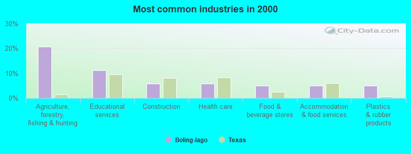
- Agriculture, forestry, fishing & hunting (20.7%)
- Educational services (11.2%)
- Construction (5.9%)
- Health care (5.9%)
- Food & beverage stores (5.0%)
- Accommodation & food services (5.0%)
- Plastics & rubber products (5.0%)
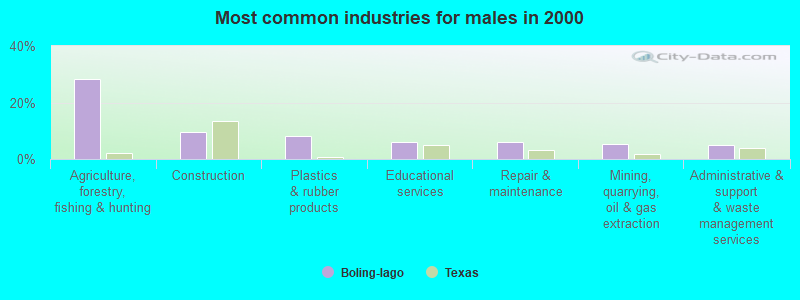
- Agriculture, forestry, fishing & hunting (28.2%)
- Construction (9.5%)
- Plastics & rubber products (8.1%)
- Educational services (5.9%)
- Repair & maintenance (5.9%)
- Mining, quarrying, oil & gas extraction (5.3%)
- Administrative & support & waste management services (5.0%)
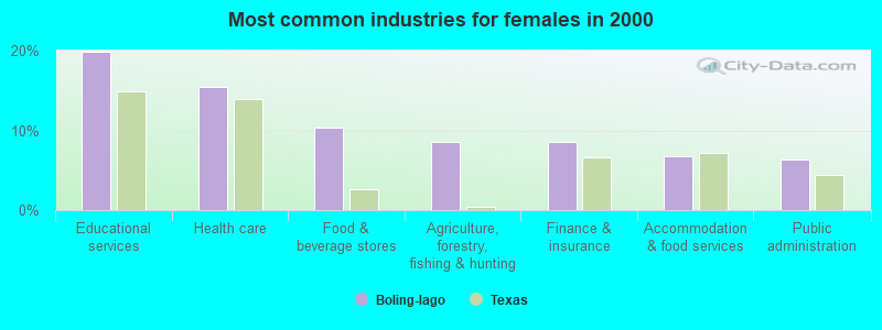
- Educational services (19.9%)
- Health care (15.4%)
- Food & beverage stores (10.4%)
- Agriculture, forestry, fishing & hunting (8.6%)
- Finance & insurance (8.6%)
- Accommodation & food services (6.8%)
- Public administration (6.3%)
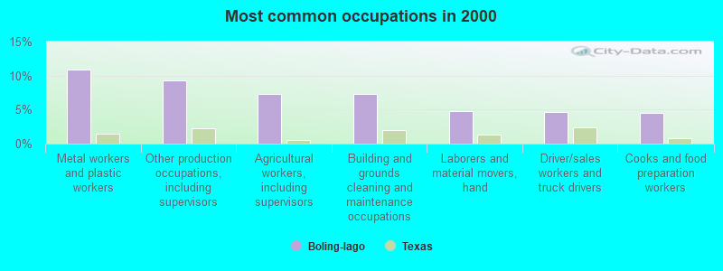
- Metal workers and plastic workers (10.9%)
- Other production occupations, including supervisors (9.3%)
- Agricultural workers, including supervisors (7.3%)
- Building and grounds cleaning and maintenance occupations (7.3%)
- Laborers and material movers, hand (4.8%)
- Driver/sales workers and truck drivers (4.7%)
- Cooks and food preparation workers (4.5%)
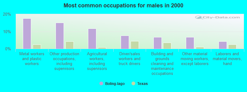
- Metal workers and plastic workers (17.6%)
- Other production occupations, including supervisors (15.1%)
- Agricultural workers, including supervisors (11.7%)
- Driver/sales workers and truck drivers (7.5%)
- Building and grounds cleaning and maintenance occupations (6.7%)
- Other material moving workers, except laborers (6.7%)
- Laborers and material movers, hand (4.2%)
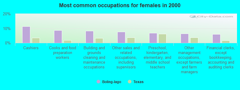
- Cashiers (11.3%)
- Cooks and food preparation workers (8.6%)
- Building and grounds cleaning and maintenance occupations (8.1%)
- Other sales and related occupations, including supervisors (7.7%)
- Preschool, kindergarten, elementary, and middle school teachers (6.8%)
- Other management occupations, except farmers and farm managers (6.3%)
- Financial clerks, except bookkeeping, accounting and auditing clerks (5.9%)
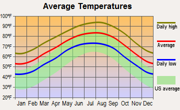
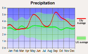
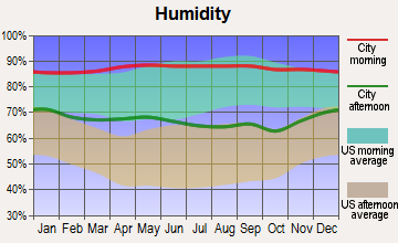
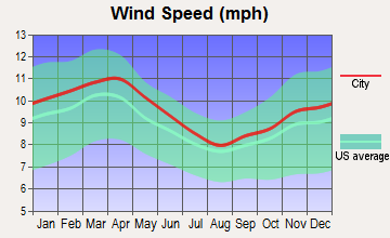
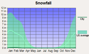
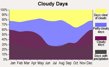
Average climate in Boling-Iago, Texas
Based on data reported by over 4,000 weather stations

Tornado activity:
Boling-Iago-area historical tornado activity is near Texas state average. It is 46% greater than the overall U.S. average.
On 11/22/1961, a category F3 (max. wind speeds 158-206 mph) tornado 12.4 miles away from the Boling-Iago place center injured one person.
On 4/19/1965, a category F3 tornado 13.2 miles away from the place center killed one person and injured 3 people and caused between $5000 and $50,000 in damages.
Earthquake activity:
Boling-Iago-area historical earthquake activity is significantly above Texas state average. It is 39% smaller than the overall U.S. average.On 10/20/2011 at 12:24:41, a magnitude 4.8 (4.8 MW, Depth: 3.1 mi, Class: Light, Intensity: IV - V) earthquake occurred 132.0 miles away from Boling-Iago center
On 5/17/2012 at 08:12:00, a magnitude 4.8 (4.8 MW, Depth: 3.1 mi) earthquake occurred 206.5 miles away from the city center
On 4/9/1993 at 12:29:19, a magnitude 4.3 (4.1 MB, 4.3 LG, Depth: 3.1 mi) earthquake occurred 135.5 miles away from the city center
On 5/1/2018 at 16:28:56, a magnitude 4.0 (4.0 MW, Depth: 3.1 mi) earthquake occurred 126.2 miles away from the city center
On 9/2/2013 at 23:51:15, a magnitude 4.3 (4.3 MW, Depth: 2.9 mi) earthquake occurred 203.9 miles away from Boling-Iago center
On 4/7/2008 at 09:51:12, a magnitude 3.9 (3.9 MW, Depth: 3.1 mi, Class: Light, Intensity: II - III) earthquake occurred 128.6 miles away from the city center
Magnitude types: regional Lg-wave magnitude (LG), body-wave magnitude (MB), moment magnitude (MW)
Natural disasters:
The number of natural disasters in Wharton County (18) is near the US average (15).Major Disasters (Presidential) Declared: 9
Emergencies Declared: 7
Causes of natural disasters: Hurricanes: 8, Storms: 6, Floods: 5, Tornadoes: 3, Fires: 2, Tropical Storm: 1, Wind: 1, Other: 1 (Note: some incidents may be assigned to more than one category).

Hospitals and medical centers near Boling-Iago:
- WHARTON NURSING AND REHABILITATION CENTER (Nursing Home, about 10 miles away; WHARTON, TX)
- WHARTON MANOR (Nursing Home, about 10 miles away; WHARTON, TX)
- BEASLEY STREET HOUSE (Hospital, about 11 miles away; NEEDVILLE, TX)
- AVALON PLACE WHARTON (Nursing Home, about 12 miles away; WHARTON, TX)
- SPJST REST HOME NO 2 (Nursing Home, about 12 miles away; NEEDVILLE, TX)
Colleges/universities with over 2000 students nearest to Boling-Iago:
- Wharton County Junior College (about 10 miles; Wharton, TX; Full-time enrollment: 5,009)
- Brazosport College (about 36 miles; Lake Jackson, TX; FT enrollment: 2,573)
- Houston Baptist University (about 40 miles; Houston, TX; FT enrollment: 2,340)
- Alvin Community College (about 44 miles; Alvin, TX; FT enrollment: 3,953)
- The Art Institute of Houston (about 44 miles; Houston, TX; FT enrollment: 2,429)
- The University of Texas Health Science Center at Houston (about 45 miles; Houston, TX; FT enrollment: 3,023)
- Rice University (about 46 miles; Houston, TX; FT enrollment: 6,713)
Points of interest:
Notable locations in Boling-Iago: Wharton County Sheriff's Office (A), Boling Fire Department (B). Display/hide their locations on the map
Cemetery: Shiloh Cemetery (1). Display/hide its location on the map
| This place: | 2.9 people |
| Texas: | 2.7 people |
| This place: | 76.0% |
| Whole state: | 71.5% |
| This place: | 6.5% |
| Whole state: | 4.4% |
Likely homosexual households (counted as self-reported same-sex unmarried-partner households)
- Lesbian couples: 0.2% of all households
- Gay men: 0.5% of all households
| This place: | 16.0% |
| Whole state: | 15.4% |
| This place: | 5.9% |
| Whole state: | 6.7% |
For population 15 years and over in Boling-Iago:
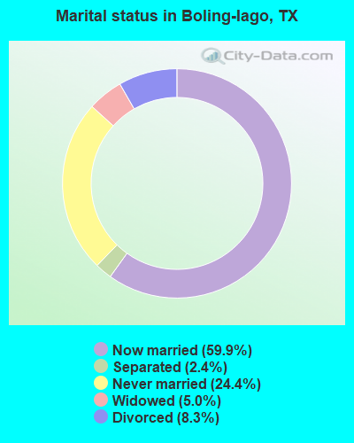
- Never married: 24.4%
- Now married: 59.9%
- Separated: 2.4%
- Widowed: 5.0%
- Divorced: 8.3%
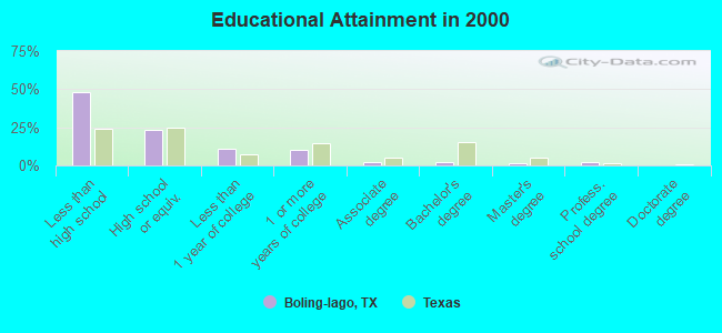
For population 25 years and over in Boling-Iago:
- High school or higher: 52.0%
- Bachelor's degree or higher: 5.4%
- Graduate or professional degree: 3.4%
- Unemployed: 4.8%
- Mean travel time to work (commute): 21.1 minutes
| Here: | 23.1 |
| Texas average: | 15.6 |
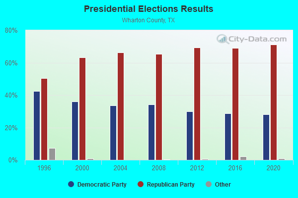
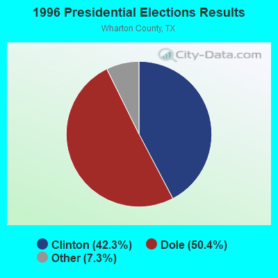
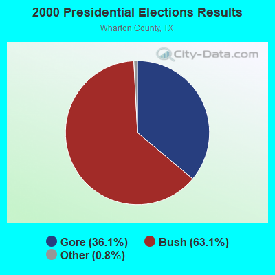
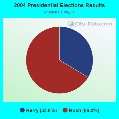
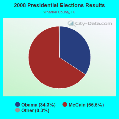
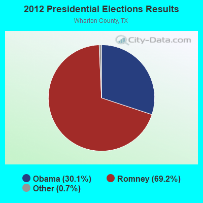


Graphs represent county-level data. Detailed 2008 Election Results
Religion statistics for Boling-Iago, TX (based on Wharton County data)
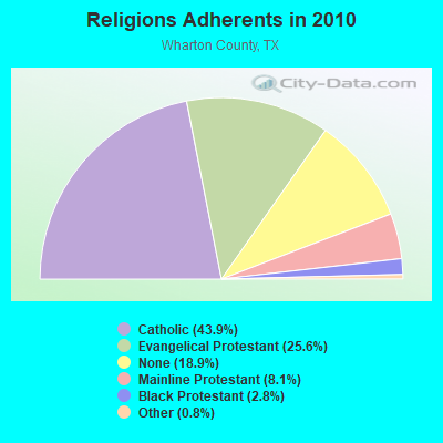
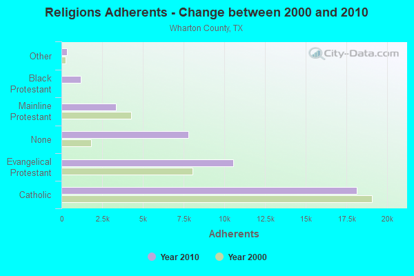
| Religion | Adherents | Congregations |
|---|---|---|
| Catholic | 18,110 | 10 |
| Evangelical Protestant | 10,550 | 48 |
| Mainline Protestant | 3,329 | 16 |
| Black Protestant | 1,169 | 7 |
| Other | 334 | 3 |
| None | 7,788 | - |
Food Environment Statistics:
| This county: | 1.96 / 10,000 pop. |
| State: | 1.47 / 10,000 pop. |
| This county: | 2.46 / 10,000 pop. |
| State: | 1.11 / 10,000 pop. |
| This county: | 7.37 / 10,000 pop. |
| Texas: | 3.95 / 10,000 pop. |
| Here: | 5.65 / 10,000 pop. |
| State: | 6.13 / 10,000 pop. |
| This county: | 10.3% |
| State: | 8.9% |
| Wharton County: | 30.5% |
| State: | 26.6% |
| Wharton County: | 19.6% |
| Texas: | 15.7% |
Strongest AM radio stations in Boling-Iago:
- KILE (1560 AM; 50 kW; BELLAIRE, TX; Owner: THE RAFTT CORPORATION)
- KEYH (850 AM; 10 kW; HOUSTON, TX; Owner: LIBERMAN BROADCASTING OF HOUSTON LICENSE CORP.)
- KTRH (740 AM; 50 kW; HOUSTON, TX; Owner: AMFM TEXAS LICENSES LIMITED PARTNERSHIP)
- KRTX (980 AM; 5 kW; ROSENBURG/RICHMOND, TX)
- KGOL (1180 AM; 50 kW; HUMBLE, TX; Owner: ENTRAVISION HOLDINGS, LLC)
- KREH (900 AM; 5 kW; PECAN GROVE, TX)
- DKFCC (1270 AM; 2 kW; BAY CITY, TX; Owner: CHAMELEON RADIO CORPORATION)
- KANI (1500 AM; 0 kW; WHARTON, TX; Owner: MARTIN BROADCASTING, INC.)
- KSEV (700 AM; 15 kW; TOMBALL, TX; Owner: LIBERMAN BROADCASTING OF HOUSTON LICENSE CORP.)
- KTMR (1130 AM; daytime; 10 kW; EDNA, TX; Owner: SIGA BROADCASTING CORPORATION)
- KCTA (1030 AM; 50 kW; CORPUS CHRISTI, TX; Owner: BROADCASTING CORPORATION OF THE SOUTHWEST)
- KTKR (760 AM; 50 kW; SAN ANTONIO, TX; Owner: CCB TEXAS LICENSES, L.P.)
- KLAT (1010 AM; 10 kW; HOUSTON, TX; Owner: TICHENOR LICENSE CORPORATION ("TLC"))
Strongest FM radio stations in Boling-Iago:
- KRBE (104.1 FM; HOUSTON, TX; Owner: KRBE LICO, INC.)
- KBXX (97.9 FM; HOUSTON, TX; Owner: RADIO ONE LICENSES, LLC)
- KHJZ-FM (95.7 FM; HOUSTON, TX; Owner: TEXAS INFINITY BROADCASTING L.P.)
- KHMX (96.5 FM; HOUSTON, TX; Owner: CITICASTERS LICENSES, L.P.)
- KILT-FM (100.3 FM; HOUSTON, TX; Owner: TEXAS INFINITY BROADCASTING L.P.)
- KKBQ-FM (92.9 FM; PASADENA, TX; Owner: CXR HOLDINGS, INC.)
- KLOL (101.1 FM; HOUSTON, TX; Owner: AMFM TEXAS LICENSES LIMITED PARTNERSHIP)
- KODA (99.1 FM; HOUSTON, TX; Owner: AMFM TEXAS LICENSES LIMITED PARTNERSHIP)
- KTBZ-FM (94.5 FM; HOUSTON, TX; Owner: AMFM TEXAS LICENSES LIMITED PARTNERSHIP)
- KKRW (93.7 FM; HOUSTON, TX; Owner: CAPSTAR TX LIMITED PARTNERSHIP)
- KUHF (88.7 FM; HOUSTON, TX; Owner: UNIVERSITY OF HOUSTON SYSTEM)
- KHCB-FM (105.7 FM; HOUSTON, TX; Owner: HOUSTON CHRISTIAN BROADCASTERS, INC.)
- KLDE (107.5 FM; LAKE JACKSON, TX; Owner: CXR HOLDINGS, INC.)
- KMJQ (102.1 FM; HOUSTON, TX; Owner: RADIO ONE LICENSES, LLC)
- KXGJ (101.7 FM; BAY CITY, TX; Owner: LIBERMAN BROADCASTING OF HOUSTON LICENSE CORP.)
- KRTS (92.1 FM; SEABROOK, TX; Owner: KRTS, INC.)
- KIOX-FM (96.9 FM; EL CAMPO, TX; Owner: LIBERMAN BROADCASTING OF HOUSTON LICENSE CORP.)
- KPTY (104.9 FM; MISSOURI CITY, TX; Owner: TICHENOR LICENSE CORPORATION ("TLC"))
- KOVE-FM (106.5 FM; GALVESTON, TX; Owner: HBC LICENSE CORPORATION)
- KJOJ-FM (103.3 FM; FREEPORT, TX; Owner: LIBERMAN BROADCASTING OF HOUSTON LICENSE CORP.)
TV broadcast stations around Boling-Iago:
- KHOU-TV (Channel 11; HOUSTON, TX; Owner: KHOU-TV, L.P.)
- KPRC-TV (Channel 2; HOUSTON, TX; Owner: POST-NEWSWEEK STATIONS, HOUSTON, LP)
- KTBU (Channel 55; CONROE, TX; Owner: HUMANITY INTERESTED MEDIA, INC.)
- KTXH (Channel 20; HOUSTON, TX; Owner: FOX TELEVISION STATIONS, INC.)
- KPXB (Channel 49; CONROE, TX; Owner: PAXSON HOUSTON LICENSE, INC.)
- KFTH (Channel 67; ALVIN, TX; Owner: TELEFUTURA HOUSTON LLC)
- KNWS-TV (Channel 51; KATY, TX; Owner: JOHNSON BROADCASTING, INC.)
- KXLN-TV (Channel 45; ROSENBERG, TX; Owner: KXLN LICENSE PARTNERSHIP, L.P.)
- KHWB (Channel 39; HOUSTON, TX; Owner: KHWB, INC.)
- KZJL (Channel 61; HOUSTON, TX; Owner: KZJL LICENSE CORP.)
- KETH (Channel 14; HOUSTON, TX; Owner: COMMUNITY EDUCATIONAL TV, INC.)
- KRIV (Channel 26; HOUSTON, TX; Owner: FOX TELEVISION STATIONS, INC.)
- KTRK-TV (Channel 13; HOUSTON, TX; Owner: KTRK TELEVISION, INC.)
- KUHT (Channel 8; HOUSTON, TX; Owner: UNIVERSITY OF HOUSTON SYSTEM)
- KVDO-LP (Channel 69; CLEAR LAKE, TX; Owner: FAR EASTERN TELECASTERS)
- KBPX-LP (Channel 33; HOUSTON, TX; Owner: PAXSON COMMUNICATIONS LPTV, INC.)
- KJIB-LP (Channel 5; CLEAR LAKE CITY, TX; Owner: FAR EASTERN TELECASTERS)
- KAZH (Channel 57; BAYTOWN, TX; Owner: KAZH LICENSE, LLC)
- KTMD (Channel 48; GALVESTON, TX; Owner: TELEMUNDO OF TEXAS PARTNERSHIP, LP)
- KHMV-LP (Channel 28; HOUSTON, TX; Owner: PAPPAS TELECASTING OF THE GULF COAST, A CALIFORNIA LP)
- KLTJ (Channel 22; GALVESTON, TX; Owner: WORD OF GOD FELLOWSHIP, INC.)
- KVIT-LP (Channel 28; VICTORIA, TX; Owner: CLUB COMMUNICATIONS)
Boling-Iago fatal accident list:
Jul 19, 2007 07:25 AM, Fm1301, Lat: 29.277631, Lon: -95.964161, Vehicles: 2, Persons: 2, Fatalities: 1
- National Bridge Inventory (NBI) Statistics
- 2Number of bridges
- 10ft / 2.6mTotal length
- 3,330Total average daily traffic
- 242Total average daily truck traffic
- 4,580Total future (year 2033) average daily traffic
FCC Registered Microwave Towers:
5- NEWGLFAP1, Lat: 29.230333 Lon: -95.919000, Type: Ltower, Structure height: 45.8 m, Call Sign: WQJY595,
Assigned Frequencies: 3650.00 MHz, Grant Date: 02/12/2019, Expiration Date: 10/17/2020, Cancellation Date: 12/19/2020, Certifier: Gregory A Angst Pe, Registrant: Mona Lee & Associates, 3730 Kirby Drive, Suite 1200 Pmb 165, Houston, TX 77098, Phone: (832) 850-7646, Email:
- NEWGLFAP2, Lat: 29.230333 Lon: -95.919000, Type: Ltower, Structure height: 45.8 m, Call Sign: WQJY595,
Assigned Frequencies: 3650.00 MHz, Grant Date: 02/12/2019, Expiration Date: 10/17/2020, Cancellation Date: 12/19/2020, Certifier: Gregory A Angst Pe, Registrant: Mona Lee & Associates, 3730 Kirby Drive, Suite 1200 Pmb 165, Houston, TX 77098, Phone: (832) 850-7646, Email:
- NEWGLFAP3, Lat: 29.230333 Lon: -95.919000, Type: Ltower, Structure height: 45.8 m, Call Sign: WQJY595,
Assigned Frequencies: 3650.00 MHz, Grant Date: 02/12/2019, Expiration Date: 10/17/2020, Cancellation Date: 12/19/2020, Certifier: Gregory A Angst Pe, Registrant: Mona Lee & Associates, 3730 Kirby Drive, Suite 1200 Pmb 165, Houston, TX 77098, Phone: (832) 850-7646, Email:
- GULFTIE SUB, 400 Vat Road (Lat: 29.262694 Lon: -95.902028), Type: Ltower, Structure height: 54.9 m, Overall height: 56.4 m, Call Sign: WRTJ967,
Assigned Frequencies: 10755.0 MHz, 6004.50 MHz, Grant Date: 06/27/2022, Expiration Date: 06/27/2032, Certifier: Jeffery Hooter, Registrant: Mona Lee & Associates, LLC, 3730 Kirby Drive, Suite 1200, Pmb 165, Houston, TX 77098, Phone: (832) 850-7646, Email:
- TX-BOLING-CN-1, Lolla Rookh (Lat: 29.257000 Lon: -95.937250), Type: Ltower, Structure height: 45.7 m, Call Sign: WRTM979,
Assigned Frequencies: 11405.0 MHz, 11405.0 MHz, 11485.0 MHz, 11485.0 MHz, 11405.0 MHz, 11405.0 MHz, 11485.0 MHz, 11485.0 MHz, 11405.0 MHz, 11405.0 MHz... (+30 more), Grant Date: 07/06/2022, Expiration Date: 07/06/2032, Certifier: Jack Marsh, Registrant: Amg Technology Investment Group, LLC, 95 Parker Oaks Lane, Hudson Oaks, TX 76087, Phone: (855) 698-5465, Email:
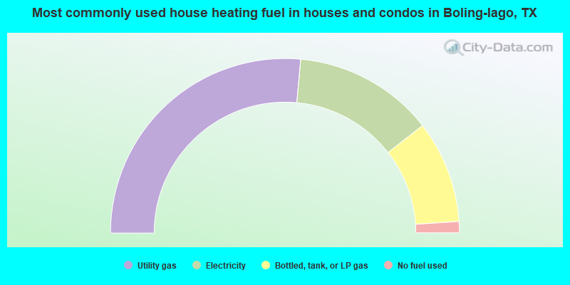
- 52.9%Utility gas
- 26.0%Electricity
- 19.0%Bottled, tank, or LP gas
- 2.1%No fuel used
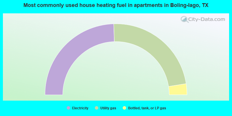
- 49.0%Electricity
- 46.0%Utility gas
- 5.0%Bottled, tank, or LP gas
Boling-Iago compared to Texas state average:
- Median house value below state average.
- Unemployed percentage significantly below state average.
- Black race population percentage below state average.
- Renting percentage significantly below state average.
- Length of stay since moving in significantly above state average.
- Number of rooms per house significantly below state average.
- House age significantly below state average.
- Percentage of population with a bachelor's degree or higher significantly below state average.