Blackfeet, Montana
Submit your own pictures of this place and show them to the world
- OSM Map
- General Map
- Google Map
- MSN Map

| Males: 4,644 | |
| Females: 4,675 |
| Median resident age: | 26.8 years |
| Montana median age: | 37.5 years |
Zip code: 59417
| Blackfeet: | $37,104 |
| MT: | $67,631 |
Estimated per capita income in 2022: $18,589 (it was $9,927 in 2000)
Blackfeet CCD income, earnings, and wages data
Estimated median house or condo value in 2022: $170,415 (it was $61,300 in 2000)
| Blackfeet: | $170,415 |
| MT: | $366,400 |
Detailed information about poverty and poor residents in Blackfeet, MT


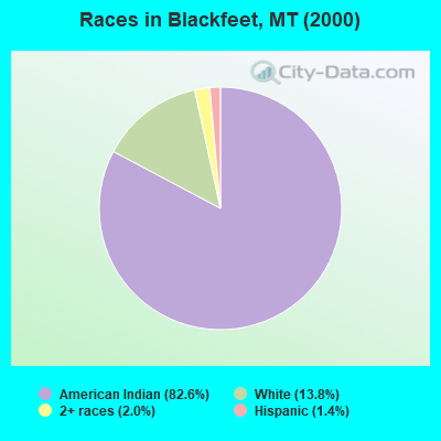
- 7,61082.6%American Indian alone
- 1,27013.8%White alone
- 1862.0%Two or more races
- 1291.4%Hispanic
- 70.08%Black alone
- 30.03%Native Hawaiian and Other
Pacific Islander alone - 30.03%Other race alone
- 10.01%Asian alone
Races in Blackfeet detailed stats: ancestries, foreign born residents, place of birth
 Recent articles from our blog. Our writers, many of them Ph.D. graduates or candidates, create easy-to-read articles on a wide variety of topics.
Current Local Time: MST time zone
Land area: 2121.8 square miles.
Population density: 4.4 people per square mile (very low).

| Blackfeet CCD: | 0.9% ($582) |
| Montana: | 1.3% ($1,212) |
Nearest city with pop. 50,000+: Great Falls, MT  (107.0 miles , pop. 56,690).
Nearest city with pop. 200,000+: East Seattle, WA (432.1 miles , pop. 480,100).
Nearest city with pop. 1,000,000+: Los Angeles, CA (1042.3 miles , pop. 3,694,820).
Nearest cities:
), ), ), ), Latitude: 48.60 N, Longitude: 112.92 W
Area code commonly used in this area: 406

| Here: | 6.2% |
| Montana: | 3.8% |
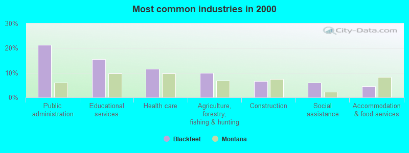
- Public administration (21.2%)
- Educational services (15.5%)
- Health care (11.6%)
- Agriculture, forestry, fishing & hunting (10.0%)
- Construction (6.7%)
- Social assistance (6.0%)
- Accommodation & food services (4.4%)
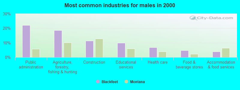
- Public administration (22.2%)
- Agriculture, forestry, fishing & hunting (18.7%)
- Construction (11.3%)
- Educational services (9.9%)
- Health care (6.8%)
- Food & beverage stores (4.7%)
- Accommodation & food services (4.0%)
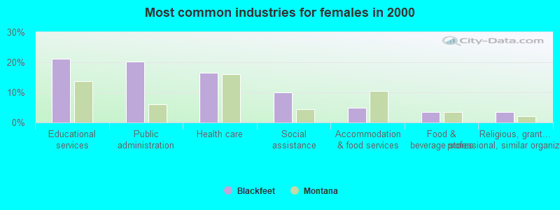
- Educational services (21.1%)
- Public administration (20.3%)
- Health care (16.5%)
- Social assistance (10.1%)
- Accommodation & food services (4.9%)
- Food & beverage stores (3.5%)
- Religious, grantmaking, civic, professional, similar organizations (3.4%)
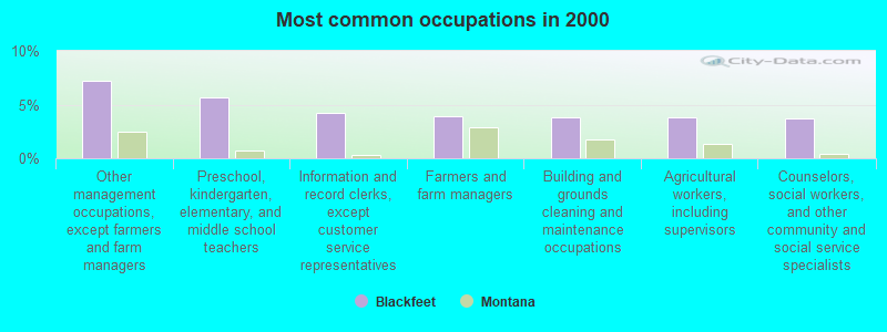
- Other management occupations, except farmers and farm managers (7.2%)
- Preschool, kindergarten, elementary, and middle school teachers (5.7%)
- Information and record clerks, except customer service representatives (4.3%)
- Farmers and farm managers (3.9%)
- Building and grounds cleaning and maintenance occupations (3.8%)
- Agricultural workers, including supervisors (3.8%)
- Counselors, social workers, and other community and social service specialists (3.7%)
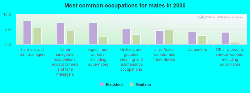
- Farmers and farm managers (7.8%)
- Other management occupations, except farmers and farm managers (7.2%)
- Agricultural workers, including supervisors (7.2%)
- Building and grounds cleaning and maintenance occupations (5.1%)
- Driver/sales workers and truck drivers (4.6%)
- Carpenters (4.2%)
- Other protective service workers, including supervisors (4.0%)
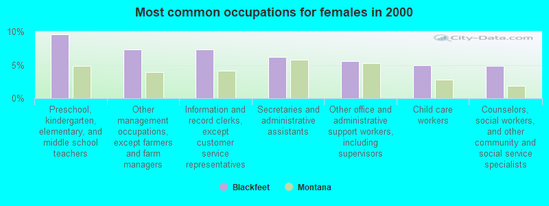
- Preschool, kindergarten, elementary, and middle school teachers (9.6%)
- Other management occupations, except farmers and farm managers (7.3%)
- Information and record clerks, except customer service representatives (7.3%)
- Secretaries and administrative assistants (6.2%)
- Other office and administrative support workers, including supervisors (5.6%)
- Child care workers (4.9%)
- Counselors, social workers, and other community and social service specialists (4.8%)
Average climate in Blackfeet, Montana
Based on data reported by over 4,000 weather stations


Earthquake activity:
Blackfeet-area historical earthquake activity is significantly above Montana state average. It is 602% greater than the overall U.S. average.On 8/18/1959 at 06:37:13, a magnitude 7.7 (7.7 UK, Class: Major, Intensity: VIII - XII) earthquake occurred 299.0 miles away from Blackfeet center, causing $26,000,000 total damage
On 10/28/1983 at 14:06:06, a magnitude 7.3 (6.2 MB, 7.3 MS, 7.0 MW) earthquake occurred 315.6 miles away from Blackfeet center, causing 2 deaths (2 shaking deaths) and 3 injuries, causing $15,000,000 total damage
On 7/6/2017 at 06:30:17, a magnitude 5.8 (5.8 MW, Depth: 7.6 mi, Class: Moderate, Intensity: VI - VII) earthquake occurred 119.9 miles away from the city center
On 3/31/2020 at 23:52:30, a magnitude 6.5 (6.5 MW, Depth: 7.5 mi, Class: Strong, Intensity: VII - IX) earthquake occurred 304.5 miles away from Blackfeet center
On 4/13/1949 at 19:55:42, a magnitude 7.0 (7.0 UK) earthquake occurred 453.4 miles away from Blackfeet center, causing $80,000,000 total damage
On 6/30/1975 at 18:54:13, a magnitude 6.1 (5.6 MB, 5.9 MS, 6.1 UK, 6.1 ML) earthquake occurred 290.7 miles away from Blackfeet center
Magnitude types: body-wave magnitude (MB), local magnitude (ML), surface-wave magnitude (MS), moment magnitude (MW)
Natural disasters:
The number of natural disasters in Glacier County (10) is smaller than the US average (15).Major Disasters (Presidential) Declared: 7
Emergencies Declared: 2
Causes of natural disasters: Floods: 5, Storms: 4, Landslides: 2, Drought: 1, Fire: 1, Heavy Rain: 1, Hurricane: 1, Snow: 1, Wind: 1, Winter Storm: 1, Other: 1 (Note: some incidents may be assigned to more than one category).
Amtrak stations near Blackfeet:
- 7 miles: BROWNING (HEART BUTTE RD. S.) - Seasonal Station . Services: enclosed waiting area, public restrooms.
- 18 miles: EAST GLACIER PARK (400 HWY 49 N.) - Seasonal Station . Services: ticket office, partially wheelchair accessible, enclosed waiting area, public restrooms, full-service food facilities, public transit connection.
Colleges/universities with over 2000 students nearest to Blackfeet:
- The University of Montana (about 130 miles; Missoula, MT; Full-time enrollment: 13,602)
- North Idaho College (about 191 miles; Coeur d'Alene, ID; FT enrollment: 4,684)
- Spokane Community College (about 215 miles; Spokane, WA; FT enrollment: 6,482)
- Whitworth University (about 216 miles; Spokane, WA; FT enrollment: 2,689)
- Gonzaga University (about 217 miles; Spokane, WA; FT enrollment: 6,780)
- Spokane Falls Community College (about 220 miles; Spokane, WA; FT enrollment: 6,052)
- Montana State University (about 222 miles; Bozeman, MT; FT enrollment: 12,942)
Points of interest:
Notable locations in Blackfeet: Magee Ranch (A), Blackfeet Agency (B), Bison Creek Ranch (C), Browning Station (D), Camp Nine (E), Chewing Blackbones Campground (F), Port of Del Bonita (G), Johnsons Campground (H), Aspenwood Camp (I), Cut Bank Golf and Country Club (J), Glacier Park Lodge Golf Course (K), Chief Mountain Junction (L), Saint Mary Triple Divide Campground (M), Two Sisters Campground (N), Leanin Tree Campground (O), Sleeping Wolf Campground (P), Duck Lake Campground (Q), Shady Grove Campground (R), Red Eagle-Two Medicine Campground (S), Smileys RV Park (T). Display/hide their locations on the map
Churches in Blackfeet include: Holy Family Mission (A), Sommer Haven Christian Church (B), Sacred Heart Mission (C), Starr Baptist Church (D), Chapel of the Ascension (E), Saint Mary Mission (F), Little Flower Parish (G), Browning United Methodist Church (H), Blackfeet United Methodist Parish (I). Display/hide their locations on the map
Cemeteries: East Glacier Park Cemetery (1), Four Horns Cemetery (2), Willow Creek Cemetery (3), Holy Family Mission Cemetery (4), Schildt Cemetery (5), Afterbuffalo Cemetery (6), Birdrattler Cemetery (7). Display/hide their locations on the map
Lakes and reservoirs: Lower Two Medicine Lake (A), Josephine Lake (B), Pike Lake (C), Kipp Lake (D), Sharp Lake (E), Spider Lake (F), Big Spring Lake (G), Carlow Lake (H). Display/hide their locations on the map
Rivers and creeks: Badger Creek (A), Coon Creek (B), Arnoux Creek (C), Freeze Out Creek (D), Cow Creek (E), Boulder Creek (F), Boundary Creek (G), South Fork Two Medicine River (H), Depot Creek (I). Display/hide their locations on the map
Parks in Blackfeet include: Blackfeet Nation Historical Marker (1), Camp Disappointment Historical Marker (2), Malmstrom Air Force Base Recreation Area (3), Old Agency 1880-1894 Historical Marker (4). Display/hide their locations on the map
| This place: | 3.2 people |
| Montana: | 2.4 people |
| This place: | 75.7% |
| Whole state: | 62.8% |
| This place: | 12.9% |
| Whole state: | 6.7% |
Likely homosexual households (counted as self-reported same-sex unmarried-partner households)
- Lesbian couples: 0.7% of all households
- Gay men: 0.4% of all households
| This place: | 33.1% |
| Whole state: | 14.6% |
| This place: | 14.4% |
| Whole state: | 5.8% |
People in group quarters in Blackfeet in 2010:
- 315 people in other noninstitutional facilities
- 84 people in workers' group living quarters and job corps centers
- 37 people in nursing facilities/skilled-nursing facilities
- 26 people in emergency and transitional shelters (with sleeping facilities) for people experiencing homelessness
- 22 people in local jails and other municipal confinement facilities
- 8 people in residential treatment centers for adults
People in group quarters in Blackfeet in 2000:
- 45 people in local jails and other confinement facilities (including police lockups)
- 39 people in nursing homes
- 30 people in other noninstitutional group quarters
- 10 people in hospitals/wards and hospices for chronically ill
- 10 people in other hospitals or wards for chronically ill
- 8 people in schools, hospitals, or wards for the intellectually disabled
- 8 people in other group homes
For population 15 years and over in Blackfeet:
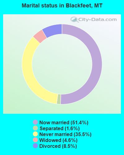
- Never married: 35.5%
- Now married: 51.4%
- Separated: 1.6%
- Widowed: 4.6%
- Divorced: 8.5%
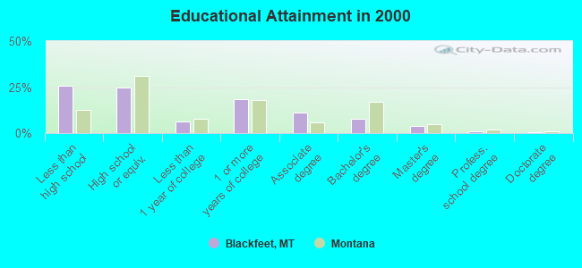
For population 25 years and over in Blackfeet:
- High school or higher: 74.3%
- Bachelor's degree or higher: 13.3%
- Graduate or professional degree: 5.4%
- Unemployed: 21.8%
- Mean travel time to work (commute): 16.1 minutes
| Here: | 12.0 |
| Montana average: | 10.4 |
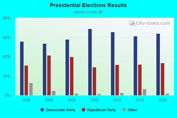
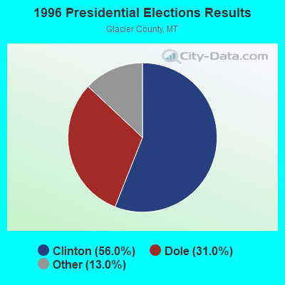
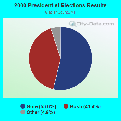
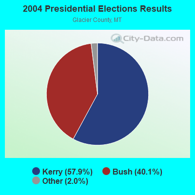
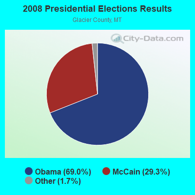
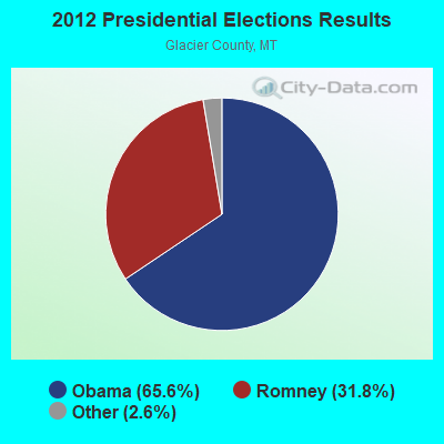
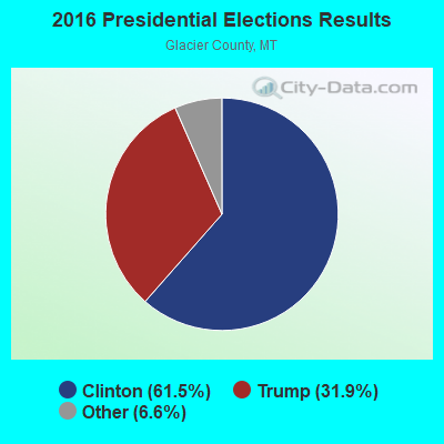
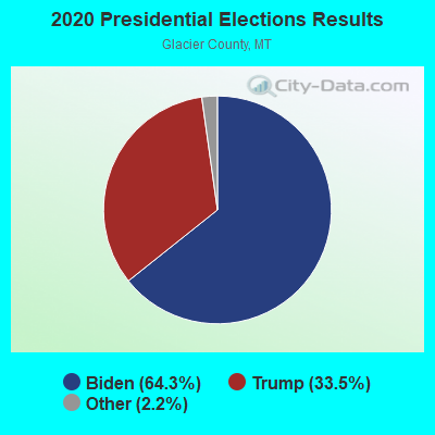
Graphs represent county-level data. Detailed 2008 Election Results
Religion statistics for Blackfeet, MT (based on Glacier County data)
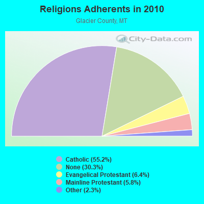
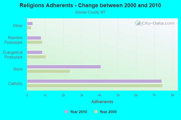
| Religion | Adherents | Congregations |
|---|---|---|
| Catholic | 7,400 | 5 |
| Evangelical Protestant | 851 | 13 |
| Mainline Protestant | 771 | 4 |
| Other | 314 | 1 |
| None | 4,063 | - |
Food Environment Statistics:
| This county: | 3.00 / 10,000 pop. |
| State: | 2.55 / 10,000 pop. |
| Glacier County: | 1.50 / 10,000 pop. |
| Montana: | 0.48 / 10,000 pop. |
| This county: | 4.50 / 10,000 pop. |
| Montana: | 4.69 / 10,000 pop. |
| Glacier County: | 9.75 / 10,000 pop. |
| Montana: | 10.38 / 10,000 pop. |
| Glacier County: | 10.9% |
| Montana: | 7.2% |
| This county: | 30.9% |
| State: | 23.1% |
| This county: | 24.0% |
| State: | 10.7% |
Strongest AM radio stations in Blackfeet:
- KOFI (1180 AM; 50 kW; KALISPELL, MT; Owner: KOFI, INC.)
- KERR (750 AM; 50 kW; POLSON, MT; Owner: ANDERSON RADIO BROADCASTING, INC.)
- KSEN (1150 AM; 10 kW; SHELBY, MT; Owner: CAPSTAR TX LIMITED PARTNERSHIP)
- KJJR (880 AM; 10 kW; WHITEFISH, MT; Owner: BEE BROADCASTING, INCORPORATED)
- KGEZ (600 AM; 5 kW; KALISPELL, MT; Owner: SKYLINE BROADCASTERS, INC.)
- KGA (1510 AM; 50 kW; SPOKANE, WA; Owner: CITADEL BROADCASTING COMPANY)
- KMON (560 AM; 5 kW; GREAT FALLS, MT; Owner: COMMONWEALTH LICENSE SUBSIDIARY, LLC)
- KTBI (810 AM; daytime; 50 kW; EPHRATA, WA; Owner: TACOMA BROADCASTERS, INCORPORATED)
- KBOI (670 AM; 50 kW; BOISE, ID; Owner: CITADEL BROADCASTING COMPANY)
- KXLY (920 AM; 20 kW; SPOKANE, WA; Owner: SPOKANE RADIO, INC.)
- KQQQ (1150 AM; 25 kW; PULLMAN, WA; Owner: RADIO PALOUSE, INC.)
- KEIN (1310 AM; 5 kW; GREAT FALLS, MT; Owner: MUNSON RADIO, INC.)
- KIRO (710 AM; 50 kW; SEATTLE, WA; Owner: ENTERCOM SEATTLE LICENSE, LLC)
Strongest FM radio stations in Blackfeet:
- KBBZ (98.5 FM; KALISPELL, MT; Owner: BEE BROADCASTING, INC.)
- KKMT (95.9 FM; COLUMBIA FALLS, MT; Owner: BEE BROADCASTING, INC.)
TV broadcast stations around Blackfeet:
- K57FM (Channel 57; BROWNING, MT; Owner: BROWNING PUBLIC SCHOOL)
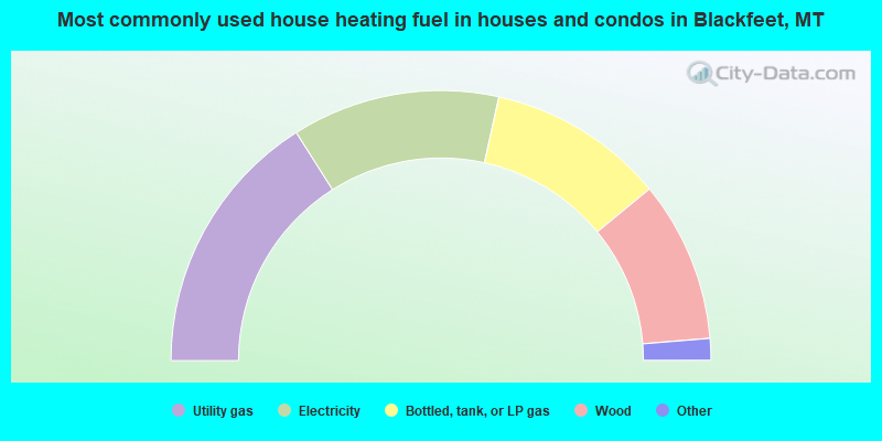
- 32.0%Utility gas
- 24.9%Electricity
- 21.2%Bottled, tank, or LP gas
- 19.3%Wood
- 1.9%Other fuel
- 0.5%Fuel oil, kerosene, etc.
- 0.3%No fuel used
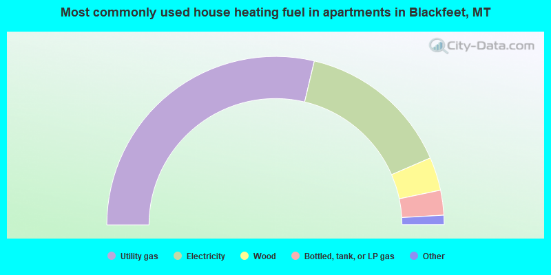
- 57.4%Utility gas
- 29.6%Electricity
- 6.4%Wood
- 4.8%Bottled, tank, or LP gas
- 1.1%Other fuel
- 0.5%Fuel oil, kerosene, etc.
- 0.3%Coal or coke
Blackfeet compared to Montana state average:
- Median household income below state average.
- Median house value below state average.
- Black race population percentage significantly below state average.
- Hispanic race population percentage significantly below state average.
- Median age significantly below state average.
- Foreign-born population percentage significantly below state average.
- Length of stay since moving in significantly above state average.
- Number of rooms per house significantly below state average.
- House age significantly below state average.
- Percentage of population with a bachelor's degree or higher below state average.
Blackfeet on our top lists:
- #10 on the list of "Top 101 cities with largest percentage of females in occupations: counselors, social workers, and other community and social service specialists (population 5,000+)"
- #11 on the list of "Top 101 cities with largest percentage of females in industries: social assistance (population 5,000+)"
- #14 on the list of "Top 101 cities with largest percentage of males in occupations: counselors, social workers, and other community and social service specialists (population 5,000+)"
- #14 on the list of "Top 101 cities with largest percentage of males in occupations: farmers and farm managers (population 5,000+)"
- #14 on the list of "Top 101 cities with the largest house values disparities (population 5,000+)"
- #15 on the list of "Top 101 cities with the largest percentage of unmarried partner households (population 5,000+)"
- #21 on the list of "Top 101 cities with largest percentage of males in industries: social assistance (population 5,000+)"
- #24 on the list of "Top 101 cities with largest percentage of females in occupations: other management occupations except farmers and farm managers (population 5,000+)"
- #24 on the list of "Top 101 cities with largest percentage of males in occupations: other protective service workers including supervisors (population 5,000+)"
- #29 on the list of "Top 101 cities with largest percentage of females in occupations: preschool, kindergarten, elementary and middle school teachers (population 5,000+)"
- #35 on the list of "Top 101 cities with largest percentage of females in industries: retail florists (population 5,000+)"
- #38 on the list of "Top 101 cities with the most people carpooling to work (population 5,000+)"
- #45 on the list of "Top 100 cities with largest land areas"
- #47 on the list of "Top 101 cities with largest percentage of males in industries: food and beverage stores (population 5,000+)"
- #62 on the list of "Top 101 cities with largest percentage of females in industries: public administration (population 5,000+)"
- #63 on the list of "Top 101 cities with largest percentage of females in industries: religious, grantmaking, civic, professional, and similar organizations (population 5,000+)"
- #65 on the list of "Top 101 cities with largest percentage of females in industries: fuel dealers (population 5,000+)"
- #98 on the list of "Top 101 cities with largest percentage of males in industries: private households (population 5,000+)"
- #7 (59417) on the list of "Top 101 zip codes with the smallest percentage of taxpayers using charity contributions deductions in 2012 (pop 5,000+)"
- #7 (59417) on the list of "Top 101 zip codes with the lowest charity contributions deductions as a percentage of AGI in 2012 (pop 5,000+)"
- #68 (59417) on the list of "Top 101 zip codes with the smallest percentage of taxpayers reporting taxable interest in 2012 (pop 5,000+)"