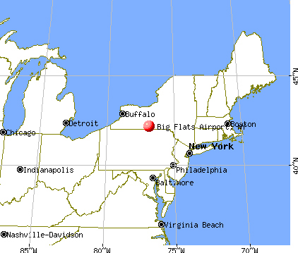
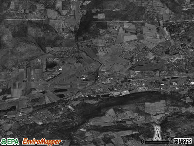
Big Flats Airport, New York
Submit your own pictures of this place and show them to the world
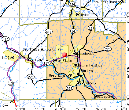
- OSM Map
- General Map
- Google Map
- MSN Map
| Males: 1,025 | |
| Females: 1,086 |
| Median resident age: | 41.4 years |
| New York median age: | 35.9 years |
Zip codes: 14845.
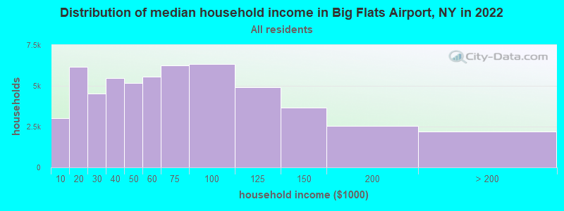
| Big Flats Airport: | $90,956 |
| NY: | $79,557 |
Estimated per capita income in 2022: $43,155 (it was $23,582 in 2000)
Big Flats Airport CDP income, earnings, and wages data
Estimated median house or condo value in 2022: $181,835 (it was $92,100 in 2000)
| Big Flats Airport: | $181,835 |
| NY: | $400,400 |
Mean prices in 2022: all housing units: $170,482; detached houses: $180,836; townhouses or other attached units: $173,487; in 2-unit structures: $137,786; in 3-to-4-unit structures: $79,646; in 5-or-more-unit structures: over $1,000,000; mobile homes: $54,295; occupied boats, rvs, vans, etc.: $68,256
Big Flats Airport, NY residents, houses, and apartments details
Detailed information about poverty and poor residents in Big Flats Airport, NY
Compare current foreclosures near Big Flats Airport, NY:
| Photo | Address | Area | Beds / Baths | Price | Details |
|---|---|---|---|---|---|

|
#1
Norton St
Elmira, NY 14901
|
1,161 sq. feet
|
1 baths 2 beds |
$16,900
|
show details |

|
#2
Wilson Hollow Rd
Corning, NY 14830
|
1,352 sq. feet
|
2 baths 3 beds |
show details | |

|
#3
Steege Hill Rd
Corning, NY 14830
|
976 sq. feet
|
1 baths 3 beds |
show details | |

|
#4
Lyon St
Elmira, NY 14904
|
1,212 sq. feet
|
1 baths 3 beds |
show details | |

|
#5
Griffith St
Corning, NY 14830
|
2,100 sq. feet
|
2 baths 4 beds |
show details | |

|
#6
Jay St
Elmira, NY 14901
|
1,568 sq. feet
|
1 baths 3 beds |
show details | |

|
#7
Reynolds Ave
Corning, NY 14830
|
864 sq. feet
|
1 baths 2 beds |
show details | |

|
#8
Standish St
Elmira, NY 14901
|
2 sq. feet
|
2 baths 3 beds |
show details | |

|
#9
Johnson St
Elmira, NY 14901
|
1,406 sq. feet
|
1 baths 3 beds |
show details | |

|
#10
Southport St
Elmira, NY 14904
|
1,792 sq. feet
|
1 baths 4 beds |
show details |
| Photo | Address | Area | Beds / Baths | Price | Details |
|---|---|---|---|---|---|

|
#11
Lattabrook Rd
Horseheads, NY 14845
|
2,400 sq. feet
|
2 baths 4 beds |
show details | |

|
#12
S Main St
Horseheads, NY 14845
|
2,510 sq. feet
|
2 baths 3 beds |
show details | |

|
#13
Owens St
Horseheads, NY 14845
|
1,800 sq. feet
|
1 baths 3 beds |
show details | |

|
#14
W 11th St
Elmira, NY 14903
|
1,536 sq. feet
|
2 baths 3 beds |
show details | |

|
#15
Wyncoop Creek Rd
Lockwood, NY 14859
|
1,568 sq. feet
|
2 baths 3 beds |
show details | |

|
#16
County Route 23
Watkins Glen, NY 14891
|
2,421 sq. feet
|
1 baths 4 beds |
show details | |

|
#17
Beeman Hollow Rd
Addison, NY 14801
|
2,512 sq. feet
|
2 baths 3 beds |
show details | |

|
#18
Gano Rd
Montour Falls, NY 14865
|
975 sq. feet
|
1 baths 2 beds |
show details | |

|
#19
Rilla St
Elmira, NY 14903
|
912 sq. feet
|
1 baths 3 beds |
show details | |

|
#20
Laurel St
Elmira, NY 14904
|
1,292 sq. feet
|
1 baths 3 beds |
show details |
| Photo | Address | Area | Beds / Baths | Price | Details |
|---|---|---|---|---|---|

|
#21
Main St
Campbell, NY 14821
|
1,644 sq. feet
|
1 baths 3 beds |
show details | |

|
#22
Plymouth Ave
Elmira, NY 14904
|
1,088 sq. feet
|
1 baths 3 beds |
show details | |

|
#23
Maple St
Corning, NY 14830
|
1,776 sq. feet
|
1 baths 4 beds |
show details | |

|
#24
Bartholomew Rd
Pine City, NY 14871
|
1,954 sq. feet
|
1 baths 3 beds |
show details | |

|
#25
Kingsbury Ave
Corning, NY 14830
|
1,159 sq. feet
|
1 baths 3 beds |
show details | |

|
#26
Hitchcock Rd
Odessa, NY 14869
|
1,232 sq. feet
|
1 baths 2 beds |
show details | |

|
#27
Locust Rd
Gillett, PA 16925
|
- sq. feet
|
- baths - beds |
$1
|
show details |

|
#28
Reynolds Ave
Corning, NY 14830
|
1,696 sq. feet
|
1 baths 3 beds |
show details | |

|
#29
Austin Hill Rd
Erin, NY 14838
|
2,282 sq. feet
|
2 baths 3 beds |
show details | |

|
#30
Thorne St
Horseheads, NY 14845
|
638 sq. feet
|
1 baths 2 beds |
show details |
| Photo | Address | Area | Beds / Baths | Price | Details |
|---|---|---|---|---|---|

|
#31
Baylor Cir
Elmira, NY 14904
|
1,175 sq. feet
|
2 baths 3 beds |
show details | |

|
#32
County Route 125
Campbell, NY 14821
|
2,268 sq. feet
|
1 baths 4 beds |
show details | |

|
#33
Post St
Elmira, NY 14904
|
1,466 sq. feet
|
1 baths 3 beds |
show details | |

|
#34
Park Ave
Elmira, NY 14901
|
1,360 sq. feet
|
1 baths 3 beds |
show details | |

|
#35
Esty St
Elmira, NY 14904
|
1,396 sq. feet
|
1 baths 3 beds |
show details | |

|
#36
Davis St
Elmira, NY 14901
|
2,106 sq. feet
|
1 baths 3 beds |
show details | |

|
#37
Redfield Dr
Elmira, NY 14905
|
1,200 sq. feet
|
2 baths 2 beds |
show details | |

|
#38
E Clinton St
Elmira, NY 14901
|
1,992 sq. feet
|
2 baths 4 beds |
show details | |

|
#39
Olcott Rd N
Big Flats, NY 14814
|
2,230 sq. feet
|
2 baths 4 beds |
show details | |

|
#40
Oakwood Ave
Elmira, NY 14903
|
2,356 sq. feet
|
2 baths 3 beds |
show details |
| Photo | Address | Area | Beds / Baths | Price | Details |
|---|---|---|---|---|---|

|
#41
Park Ln
Big Flats, NY 14814
|
1,688 sq. feet
|
1 baths 3 beds |
show details | |

|
#42
W 15th St
Elmira, NY 14903
|
1,562 sq. feet
|
2 baths 4 beds |
show details | |

|
#43
Eacher Hollow Rd
Horseheads, NY 14845
|
2,024 sq. feet
|
1 baths 3 beds |
show details | |

|
#44
Collins St
Elmira, NY 14904
|
1,296 sq. feet
|
1 baths 3 beds |
show details | |

|
#45
Wygant Rd
Horseheads, NY 14845
|
1,176 sq. feet
|
1 baths 3 beds |
show details | |

|
#46
Deery Hill Rd
Gillett, PA 16925
|
- sq. feet
|
- baths - beds |
show details | |

|
#47
Spencer Hill Rd
Corning, NY 14830
|
- sq. feet
|
- baths - beds |
show details | |

|
#48
Woods Edge Dr
Painted Post, NY 14870
|
- sq. feet
|
- baths - beds |
show details | |

|
#49
Creekside Dr Apt 201
Painted Post, NY 14870
|
- sq. feet
|
- baths - beds |
show details | |

|
Check over 1 million property listings on Foreclosure.com!
|
browse all offers | |||

- 2,10296.2%White alone
- 321.5%Asian alone
- 291.3%Black alone
- 150.7%Two or more races
- 60.3%Hispanic
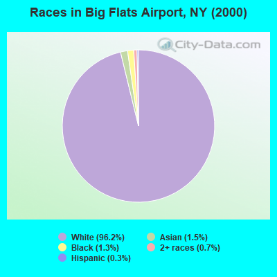
Races in Big Flats Airport detailed stats: ancestries, foreign born residents, place of birth
 Recent articles from our blog. Our writers, many of them Ph.D. graduates or candidates, create easy-to-read articles on a wide variety of topics.

Ancestries: German (27.6%), Irish (20.1%), English (12.7%), Italian (11.4%), Polish (9.1%), United States (5.7%).
Current Local Time: EST time zone
Land area: 11.7 square miles.
Population density: 180 people per square mile (very low).
76 residents are foreign born (1.7% Europe, 1.5% Asia).
| This place: | 3.5% |
| New York: | 20.4% |
| Big Flats Airport CDP: | 2.5% ($2,328) |
| New York: | 1.9% ($2,847) |
Nearest city with pop. 50,000+: Union, NY (44.1 miles  , pop. 56,298).
Nearest city with pop. 200,000+: Rochester, NY (78.7 miles , pop. 219,773).
Nearest city with pop. 1,000,000+: Philadelphia, PA (175.0 miles , pop. 1,517,550).
Nearest cities:
), ), ), ), )Latitude: 42.16 N, Longitude: 76.88 W
Daytime population change due to commuting: +2,937 (+134.5%)
Workers who live and work in this place: 141 (12.6%)
Area code commonly used in this area: 607
| Here: | 4.5% |
| New York: | 4.4% |
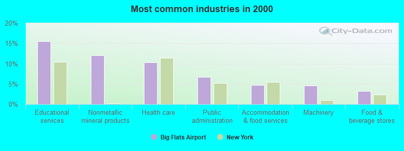
- Educational services (15.5%)
- Nonmetallic mineral products (12.0%)
- Health care (10.3%)
- Public administration (6.7%)
- Accommodation & food services (4.7%)
- Machinery (4.6%)
- Food & beverage stores (3.3%)
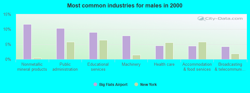
- Nonmetallic mineral products (11.7%)
- Public administration (10.3%)
- Educational services (9.0%)
- Machinery (7.9%)
- Health care (4.6%)
- Accommodation & food services (4.4%)
- Broadcasting & telecommunications (4.3%)
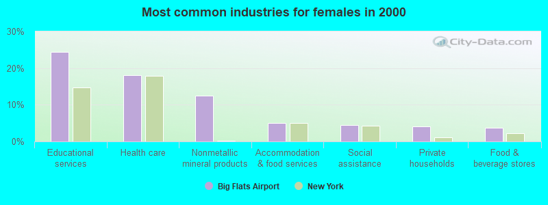
- Educational services (24.4%)
- Health care (18.2%)
- Nonmetallic mineral products (12.5%)
- Accommodation & food services (5.0%)
- Social assistance (4.4%)
- Private households (4.2%)
- Food & beverage stores (3.8%)
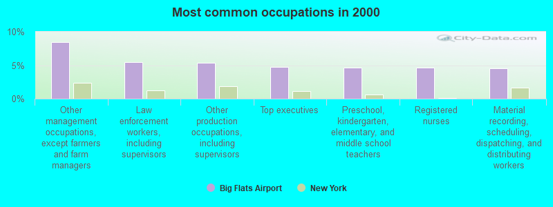
- Other management occupations, except farmers and farm managers (8.4%)
- Law enforcement workers, including supervisors (5.5%)
- Other production occupations, including supervisors (5.4%)
- Top executives (4.7%)
- Preschool, kindergarten, elementary, and middle school teachers (4.7%)
- Registered nurses (4.7%)
- Material recording, scheduling, dispatching, and distributing workers (4.5%)
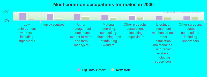
- Law enforcement workers, including supervisors (9.4%)
- Top executives (8.2%)
- Other management occupations, except farmers and farm managers (7.4%)
- Material recording, scheduling, dispatching, and distributing workers (6.1%)
- Other production occupations, including supervisors (5.8%)
- Electrical equipment mechanics and other installation, maintenance, and repair workers, including supervisors (5.2%)
- Other sales and related occupations, including supervisors (4.7%)

- Other management occupations, except farmers and farm managers (9.8%)
- Registered nurses (9.4%)
- Other office and administrative support workers, including supervisors (9.2%)
- Preschool, kindergarten, elementary, and middle school teachers (7.1%)
- Other teachers, instructors, education, training, and library occupations (5.8%)
- Cashiers (5.6%)
- Secretaries and administrative assistants (5.4%)
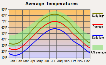
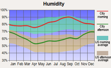
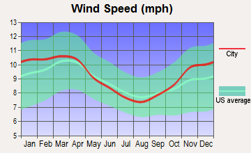
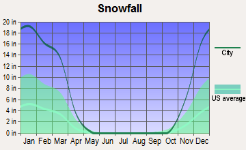
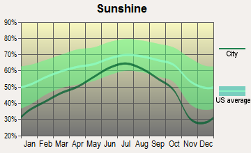
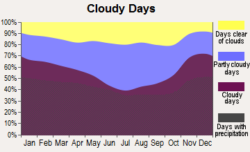
Average climate in Big Flats Airport, New York
Based on data reported by over 4,000 weather stations
(lower is better)
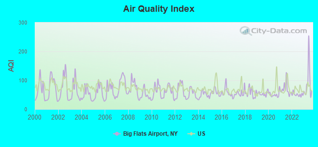
Air Quality Index (AQI) level in 2023 was 92.1. This is worse than average.
| City: | 92.1 |
| U.S.: | 72.6 |
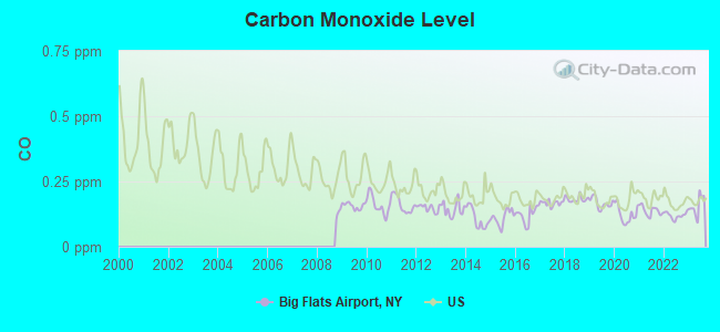
Carbon Monoxide (CO) [ppm] level in 2023 was 0.156. This is significantly better than average. Closest monitor was 5.4 miles away from the city center.
| City: | 0.156 |
| U.S.: | 0.251 |
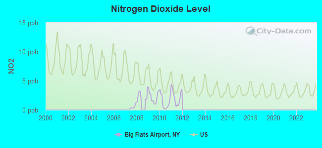
Nitrogen Dioxide (NO2) [ppb] level in 2011 was 2.25. This is significantly better than average. Closest monitor was 5.4 miles away from the city center.
| City: | 2.25 |
| U.S.: | 5.11 |
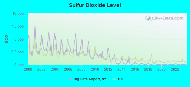
Sulfur Dioxide (SO2) [ppb] level in 2023 was 0.0309. This is significantly better than average. Closest monitor was 5.4 miles away from the city center.
| City: | 0.0309 |
| U.S.: | 1.5147 |
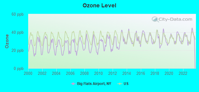
Ozone [ppb] level in 2023 was 36.5. This is about average. Closest monitor was 5.4 miles away from the city center.
| City: | 36.5 |
| U.S.: | 33.3 |
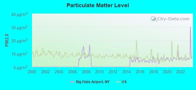
Particulate Matter (PM2.5) [µg/m3] level in 2023 was 9.50. This is about average. Closest monitor was 17.6 miles away from the city center.
| City: | 9.50 |
| U.S.: | 8.11 |
Tornado activity:
Big Flats Airport-area historical tornado activity is near New York state average. It is 62% smaller than the overall U.S. average.
On 8/30/1955, a category F3 (max. wind speeds 158-206 mph) tornado 11.7 miles away from the Big Flats Airport place center caused between $5000 and $50,000 in damages.
On 5/2/1983, a category F3 tornado 13.8 miles away from the place center injured 6 people and caused between $500,000 and $5,000,000 in damages.
Earthquake activity:
Big Flats Airport-area historical earthquake activity is significantly above New York state average. It is 66% smaller than the overall U.S. average.On 10/7/1983 at 10:18:46, a magnitude 5.3 (5.1 MB, 5.3 LG, 5.1 ML, Class: Moderate, Intensity: VI - VII) earthquake occurred 178.2 miles away from Big Flats Airport center
On 8/23/2011 at 17:51:04, a magnitude 5.8 (5.8 MW, Depth: 3.7 mi) earthquake occurred 299.5 miles away from the city center
On 9/25/1998 at 19:52:52, a magnitude 5.2 (4.8 MB, 4.3 MS, 5.2 LG, 4.5 MW, Depth: 3.1 mi) earthquake occurred 187.1 miles away from Big Flats Airport center
On 4/20/2002 at 10:50:47, a magnitude 5.3 (5.3 ML, Depth: 3.0 mi) earthquake occurred 228.1 miles away from Big Flats Airport center
On 4/20/2002 at 10:50:47, a magnitude 5.2 (5.2 MB, 4.2 MS, 5.2 MW, 5.0 MW) earthquake occurred 226.1 miles away from Big Flats Airport center
On 1/16/1994 at 01:49:16, a magnitude 4.6 (4.6 MB, 4.6 LG, Depth: 3.1 mi, Class: Light, Intensity: IV - V) earthquake occurred 134.2 miles away from Big Flats Airport center
Magnitude types: regional Lg-wave magnitude (LG), body-wave magnitude (MB), local magnitude (ML), surface-wave magnitude (MS), moment magnitude (MW)
Natural disasters:
The number of natural disasters in Chemung County (16) is near the US average (15).Major Disasters (Presidential) Declared: 9
Emergencies Declared: 6
Causes of natural disasters: Floods: 6, Storms: 6, Tropical Storms: 3, Hurricanes: 2, Tornadoes: 2, Blizzard: 1, Flash Flood: 1, Heavy Rain: 1, Landslide: 1, Power Outage: 1, Wind: 1, Other: 2 (Note: some incidents may be assigned to more than one category).
Hospitals and medical centers near Big Flats Airport:
- GUTHRIE SAME DAY SURGERY CENTER INC (Hospital, about 1 miles away; HORSEHEADS, NY)
- ELCOR NURSING AND REHABILITATION CENTER (Nursing Home, about 2 miles away; HORSEHEADS, NY)
- BETHANY MANOR HRF (Nursing Home, about 3 miles away; HORSEHEADS, NY)
- BETHANY NURSING HOME (Nursing Home, about 4 miles away; HORSEHEADS, NY)
- CHEMUNG COUNTY CHAPTER NYS ARC, INC (Hospital, about 4 miles away; ELMIRA, NY)
- UCPA OF CHEMUNG COUNTY (Hospital, about 4 miles away; HORSEHEADS, NY)
- UCPA OF CHEMUNG COUNTY (Hospital, about 5 miles away; ELMIRA HEIGHTS, NY)
Colleges/universities with over 2000 students nearest to Big Flats Airport:
- Corning Community College (about 11 miles; Corning, NY; Full-time enrollment: 3,036)
- Ithaca College (about 27 miles; Ithaca, NY; FT enrollment: 6,781)
- Mansfield University of Pennsylvania (about 28 miles; Mansfield, PA; FT enrollment: 2,826)
- Cornell University (about 29 miles; Ithaca, NY; FT enrollment: 20,360)
- Tompkins Cortland Community College (about 39 miles; Dryden, NY; FT enrollment: 3,884)
- SUNY College at Cortland (about 46 miles; Cortland, NY; FT enrollment: 6,838)
- SUNY at Binghamton (about 47 miles; Vestal, NY; FT enrollment: 15,096)
Points of interest:
Notable location: National Warplane Museum (A). Display/hide its location on the map
Shopping Center: Arnot Mall Shopping Center (1). Display/hide its location on the map
Church in Big Flats Airport: Maranatha Bible Chapel (A). Display/hide its location on the map
Cemeteries: Goff Cemetery (1), Whitney Cemetery (2). Display/hide their locations on the map
| This place: | 2.7 people |
| New York: | 2.6 people |
| This place: | 80.2% |
| Whole state: | 66.2% |
| This place: | 3.4% |
| Whole state: | 5.4% |
Likely homosexual households (counted as self-reported same-sex unmarried-partner households)
- Lesbian couples: 0.0% of all households
- Gay men: 0.1% of all households
| This place: | 3.7% |
| Whole state: | 14.6% |
| This place: | 1.4% |
| Whole state: | 7.4% |
For population 15 years and over in Big Flats Airport:
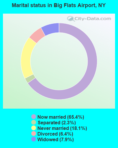
- Never married: 18.1%
- Now married: 65.4%
- Separated: 2.3%
- Widowed: 7.9%
- Divorced: 6.4%
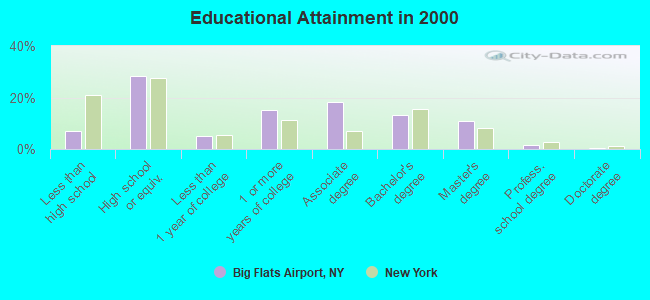
For population 25 years and over in Big Flats Airport:
- High school or higher: 93.2%
- Bachelor's degree or higher: 26.0%
- Graduate or professional degree: 12.8%
- Unemployed: 5.1%
- Mean travel time to work (commute): 16.6 minutes
| Here: | 8.9 |
| New York average: | 14.2 |
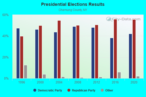
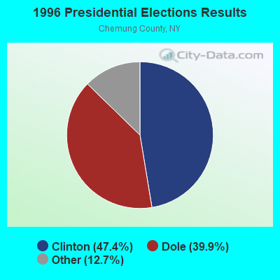
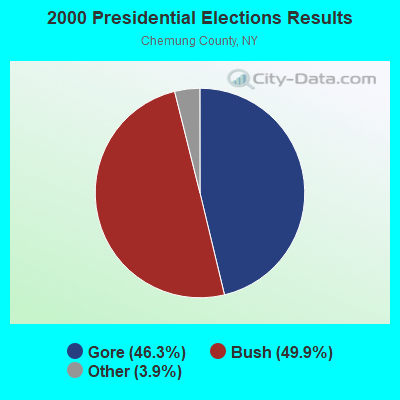

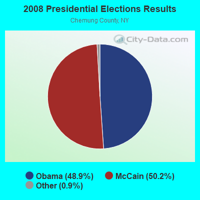
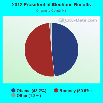

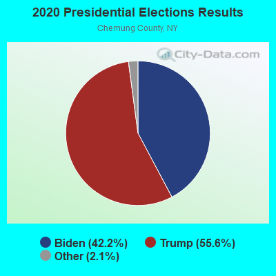
Graphs represent county-level data. Detailed 2008 Election Results
Religion statistics for Big Flats Airport, NY (based on Chemung County data)
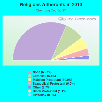
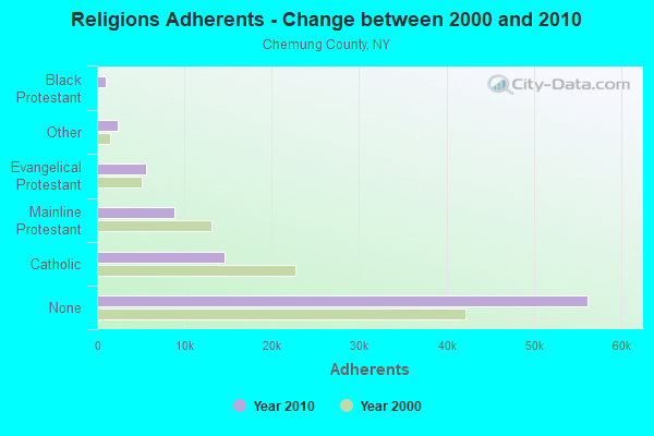
| Religion | Adherents | Congregations |
|---|---|---|
| Catholic | 14,593 | 5 |
| Mainline Protestant | 8,842 | 46 |
| Evangelical Protestant | 5,604 | 46 |
| Other | 2,399 | 8 |
| Black Protestant | 965 | 3 |
| Orthodox | 230 | 2 |
| None | 56,197 | - |
Food Environment Statistics:
| Chemung County: | 1.36 / 10,000 pop. |
| State: | 4.13 / 10,000 pop. |
| Chemung County: | 0.11 / 10,000 pop. |
| New York: | 0.06 / 10,000 pop. |
| Chemung County: | 1.59 / 10,000 pop. |
| State: | 0.92 / 10,000 pop. |
| Here: | 3.30 / 10,000 pop. |
| New York: | 1.68 / 10,000 pop. |
| Chemung County: | 7.62 / 10,000 pop. |
| New York: | 8.82 / 10,000 pop. |
| Chemung County: | 9.1% |
| State: | 8.2% |
| Here: | 27.0% |
| New York: | 23.8% |
| This county: | 13.2% |
| New York: | 15.6% |
Strongest AM radio stations in Big Flats Airport:
- WLNL (1000 AM; daytime; 5 kW; HORSEHEADS, NY; Owner: LIGHTHOUSE MEDIA, INC.)
- WWLZ (820 AM; 4 kW; HORSEHEADS, NY; Owner: CHEMUNG COUNTY RADIO, INC.)
- WEHH (1590 AM; 5 kW; ELMIRA HTS/HORSEHEAD, NY; Owner: PEMBROOK PINES ELMIRA, LTD.)
- WELM (1410 AM; 5 kW; ELMIRA, NY; Owner: PEMBROOK PINES ELMIRA, LIMITED)
- WENY (1230 AM; 1 kW; ELMIRA, NY; Owner: EOLIN BROADCASTING, INC.)
- WABH (1380 AM; 10 kW; BATH, NY)
- WATS (960 AM; 5 kW; SAYRE, PA; Owner: WATS BROADCASTING, INC.)
- WCBA (1350 AM; 1 kW; CORNING, NY)
- WCLI (1450 AM; 1 kW; CORNING, NY; Owner: EOLIN BROADCASTING, INC.)
- WHAM (1180 AM; 50 kW; ROCHESTER, NY; Owner: CITICASTERS LICENSES, L.P.)
- WPIE (1160 AM; 5 kW; TRUMANSBURG, NY; Owner: PEMBROOK PINES ITHACA LTD. N.A.)
- WTKO (1470 AM; 5 kW; ITHACA, NY; Owner: EAGLE II BROADCASTING CORPORATION)
- WHCU (870 AM; 5 kW; ITHACA, NY; Owner: EAGLE BROADCASTING COMPANY, INC.)
Strongest FM radio stations in Big Flats Airport:
- WSQE (91.1 FM; CORNING, NY; Owner: WSKG PUB. TELECOMMUNICATIONS COUNCIL)
- WOKN (99.5 FM; SOUTHPORT, NY; Owner: PEMBROOK PINES ELMIRA, LTD.)
- WLVY (94.3 FM; ELMIRA, NY; Owner: PEMBROOK PINES ELMIRA, LTD.)
- W205BR (88.9 FM; ELMIRA, NY; Owner: PENSACOLA CHRISTIAN COLLEGE, INC.)
- WPGI (100.9 FM; HORSEHEADS, NY; Owner: CHEMUNG COUNTY RADIO, INC.)
- WCBA-FM (98.7 FM; CORNING, NY; Owner: EOLIN BROADCASTING, INC.)
- WNGZ (104.9 FM; MONTOUR FALLS, NY; Owner: CHEMUNG COUNTY RADIO, INC.)
- WNKI (106.1 FM; CORNING, NY; Owner: CHEMUNG COUNTY RADIO, INC.)
- WGMM (97.7 FM; BIG FLATS, NY; Owner: EOLIN BROADCASTING, INC.)
- WENY-FM (92.7 FM; ELMIRA, NY; Owner: EOLIN BROADCASTING, INC.)
- W201CO (88.1 FM; ELMIRA, NY; Owner: FAMILY LIFE MINISTRIES, INC.)
- WMTT (94.7 FM; TIOGA, PA; Owner: EUROPA COMMUNICATIONS, INC.)
- WQNY (103.7 FM; ITHACA, NY; Owner: EAGLE II BROADCASTING CORPORATION)
- W236AK (95.1 FM; CORNING, NY; Owner: EUROPA COMMUNICATIONS, INC.)
- WNBQ (92.3 FM; MANSFIELD, PA; Owner: FARM & HOME BROADCASTING COMPANY)
- WCIH (90.3 FM; ELMIRA, NY; Owner: FAMILY LIFE MINISTRIES, INC.)
- WREQ (96.9 FM; RIDGEBURY, PA; Owner: CSN INTERNATIONAL)
- WHGL-FM (100.3 FM; CANTON, PA; Owner: CANTROAIR COMMUNICATIONS INC.)
- WYXL (97.3 FM; ITHACA, NY; Owner: EAGLE BROADCASTING COMPANY)
- WAVR (102.3 FM; WAVERLY, NY; Owner: WATS BROADCASTING, INC.)
TV broadcast stations around Big Flats Airport:
- WETM-TV (Channel 18; ELMIRA, NY; Owner: SMITH TELEVISION OF NEW YORK LICENSE HOLDINGS, INC.)
- WENY-TV (Channel 36; ELMIRA, NY; Owner: LILLY BROADCASTING, L.L.C.)
- W21BW (Channel 21; ELMIRA, NY; Owner: THREE ANGELS BROADCASTING NETWORK INC.)
- W59DG (Channel 59; ELMIRA, NY; Owner: TRINITY BROADCASTING NETWORK)
- W26BF (Channel 26; ELMIRA, NY; Owner: WYDC, INC.)
- WYDC (Channel 48; CORNING, NY; Owner: WYDC, INC.)
- W60AD (Channel 60; SAVONA, NY; Owner: WSKG PUBLIC TELECOMMUNICATIONS COUNCIL)
- W30AA (Channel 30; ELMIRA, NY; Owner: WSKG PUBLIC TELECOMMUNICATIONS COUNCIL)
- W52CE (Channel 52; SAYRE, PA; Owner: WOLF LICENSE CORP.)
- W20BL (Channel 20; BATH, NY; Owner: WYDC, INC.)
- National Bridge Inventory (NBI) Statistics
- 17Number of bridges
- 121ft / 36.5mTotal length
- $25,791,000Total costs
- 113,252Total average daily traffic
- 10,117Total average daily truck traffic
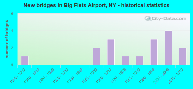
- New bridges - historical statistics
- 11900-1909
- 21950-1959
- 31960-1969
- 11970-1979
- 11980-1989
- 31990-1999
- 42000-2009
- 22010-2019
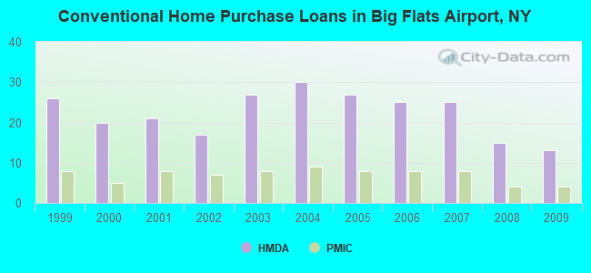
| Home Mortgage Disclosure Act Aggregated Statistics For Year 2009 (Based on 1 partial tract) | ||||||||||||
| A) FHA, FSA/RHS & VA Home Purchase Loans | B) Conventional Home Purchase Loans | C) Refinancings | D) Home Improvement Loans | F) Non-occupant Loans on < 5 Family Dwellings (A B C & D) | G) Loans On Manufactured Home Dwelling (A B C & D) | |||||||
|---|---|---|---|---|---|---|---|---|---|---|---|---|
| Number | Average Value | Number | Average Value | Number | Average Value | Number | Average Value | Number | Average Value | Number | Average Value | |
| LOANS ORIGINATED | 6 | $152,702 | 13 | $144,338 | 41 | $127,116 | 12 | $45,667 | 1 | $172,460 | 1 | $76,420 |
| APPLICATIONS APPROVED, NOT ACCEPTED | 0 | $0 | 1 | $238,670 | 3 | $124,393 | 1 | $47,370 | 0 | $0 | 0 | $0 |
| APPLICATIONS DENIED | 1 | $67,520 | 1 | $90,550 | 4 | $155,385 | 2 | $14,655 | 0 | $0 | 0 | $0 |
| APPLICATIONS WITHDRAWN | 0 | $0 | 1 | $176,650 | 8 | $114,036 | 1 | $123,000 | 0 | $0 | 0 | $0 |
| FILES CLOSED FOR INCOMPLETENESS | 0 | $0 | 0 | $0 | 2 | $129,540 | 0 | $0 | 0 | $0 | 0 | $0 |
Detailed HMDA statistics for the following Tracts: 0103.00
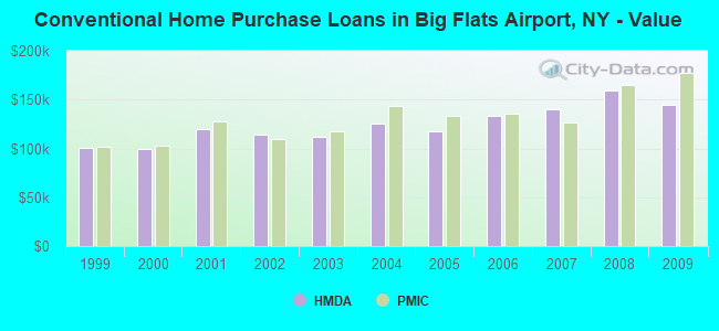
| Private Mortgage Insurance Companies Aggregated Statistics For Year 2009 (Based on 1 partial tract) | ||||
| A) Conventional Home Purchase Loans | B) Refinancings | |||
|---|---|---|---|---|
| Number | Average Value | Number | Average Value | |
| LOANS ORIGINATED | 4 | $177,695 | 2 | $215,770 |
| APPLICATIONS APPROVED, NOT ACCEPTED | 0 | $0 | 1 | $86,880 |
| APPLICATIONS DENIED | 0 | $0 | 0 | $0 |
| APPLICATIONS WITHDRAWN | 0 | $0 | 1 | $51,820 |
| FILES CLOSED FOR INCOMPLETENESS | 0 | $0 | 0 | $0 |
Detailed PMIC statistics for the following Tracts: 0103.00
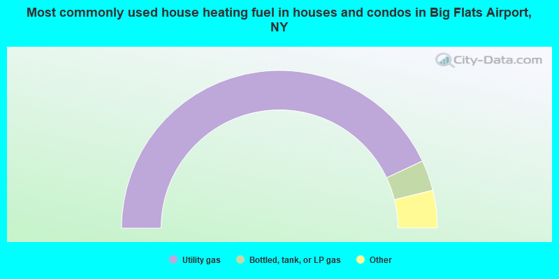
- 86.1%Utility gas
- 6.3%Bottled, tank, or LP gas
- 3.6%Fuel oil, kerosene, etc.
- 3.1%Electricity
- 1.0%Wood
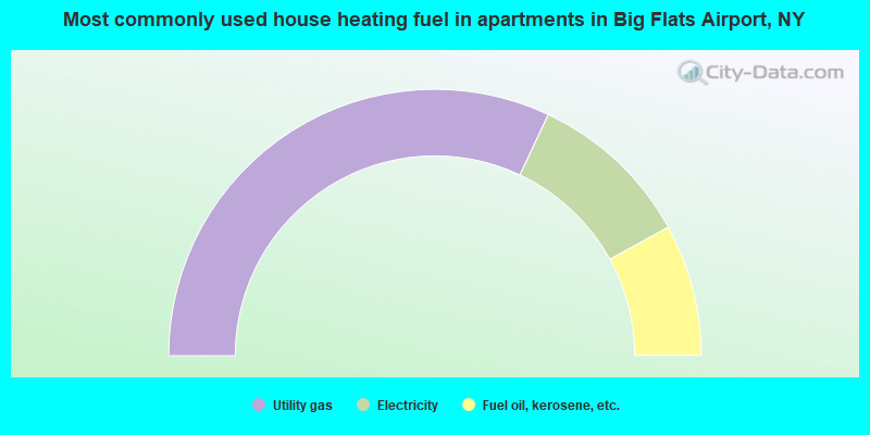
- 64.0%Utility gas
- 20.0%Electricity
- 16.0%Fuel oil, kerosene, etc.
Big Flats Airport compared to New York state average:
- Median house value below state average.
- Unemployed percentage significantly below state average.
- Black race population percentage significantly below state average.
- Hispanic race population percentage significantly below state average.
- Foreign-born population percentage significantly below state average.
- Renting percentage significantly below state average.
- Length of stay since moving in significantly above state average.
- Number of rooms per house significantly below state average.
- House age significantly below state average.
- Number of college students below state average.