Bexar, Alabama
Submit your own pictures of this place and show them to the world
- OSM Map
- General Map
- Google Map
- MSN Map

| Males: 824 | |
| Females: 798 |
| Median resident age: | 39.0 years |
| Alabama median age: | 35.8 years |
Zip code: 35593
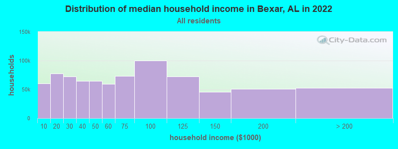
| Bexar: | $48,690 |
| AL: | $59,674 |
Estimated per capita income in 2022: $23,283 (it was $13,971 in 2000)
Bexar CCD income, earnings, and wages data
Estimated median house or condo value in 2022: $110,740 (it was $53,000 in 2000)
| Bexar: | $110,740 |
| AL: | $200,900 |
Mean prices in 2022: all housing units: $135,673; detached houses: $154,925; townhouses or other attached units: $138,437; mobile homes: $60,335; occupied boats, rvs, vans, etc.: $23,120
Detailed information about poverty and poor residents in Bexar, AL
Compare current foreclosures near Bexar, AL:
| Photo | Address | Area | Beds / Baths | Price | Details |
|---|---|---|---|---|---|

|
#1
Highway 19 S
Red Bay, AL 35582
|
2,814 sq. feet
|
2 baths 4 beds |
$180,000
|
show details |

|
#2
Beecher St
Hamilton, AL 35570
|
1,263 sq. feet
|
2 baths 2 beds |
$57,500
|
show details |

|
#3
Pearce Chapel Rd
Smithville, MS 38870
|
1,645 sq. feet
|
1 baths - beds |
$27,900
|
show details |

|
#4
County Highway 180
Hamilton, AL 35570
|
1,690 sq. feet
|
2 baths 3 beds |
show details | |

|
#5
Water Tank Dr
Tremont, MS 38876
|
1,208 sq. feet
|
2 baths 3 beds |
show details | |

|
#6
Kemp Rd
Hamilton, AL 35570
|
1,064 sq. feet
|
- baths - beds |
show details | |

|
#7
11th Ave NE
Red Bay, AL 35582
|
1,539 sq. feet
|
- baths - beds |
show details | |

|
#8
Johnson Heights Dr
Fulton, MS 38843
|
1,354 sq. feet
|
- baths - beds |
show details | |

|
#9
Fairview Banner Rd
Golden, MS 38847
|
- sq. feet
|
- baths - beds |
show details | |

|
#10
Highway 25 S
Fulton, MS 38843
|
1,161 sq. feet
|
- baths - beds |
show details |
| Photo | Address | Area | Beds / Baths | Price | Details |
|---|---|---|---|---|---|

|
#11
Highway 19 S
Red Bay, AL 35582
|
- sq. feet
|
- baths - beds |
show details | |

|
#12
Bullen Dr
Red Bay, AL 35582
|
- sq. feet
|
- baths - beds |
show details | |

|
#13
8th Ave SE
Red Bay, AL 35582
|
- sq. feet
|
- baths - beds |
show details | |

|
#14
Fairview Church Rd
Golden, MS 38847
|
- sq. feet
|
- baths - beds |
show details | |

|
#15
9th St W
Red Bay, AL 35582
|
- sq. feet
|
- baths - beds |
show details | |

|
#16
Four Oaks Rd
Beaverton, AL 35544
|
972 sq. feet
|
- baths - beds |
show details | |

|
#17
7th Ave SW
Red Bay, AL 35582
|
- sq. feet
|
- baths - beds |
show details | |

|
#18
Highway 25 S
Fulton, MS 38843
|
- sq. feet
|
- baths - beds |
show details | |

|
#19
Mills Rd
Hamilton, AL 35570
|
1,541 sq. feet
|
- baths - beds |
show details | |

|
#20
Old Highway 25 N
Fulton, MS 38843
|
- sq. feet
|
- baths - beds |
show details |
| Photo | Address | Area | Beds / Baths | Price | Details |
|---|---|---|---|---|---|

|
#21
County Highway 42
Hamilton, AL 35570
|
- sq. feet
|
- baths - beds |
show details | |

|
#22
10th Ave NW
Red Bay, AL 35582
|
- sq. feet
|
- baths - beds |
show details | |

|
#23
County Road 42
Hamilton, AL 35570
|
- sq. feet
|
- baths - beds |
show details | |

|
#24
Cobb Stump Rd
Fulton, MS 38843
|
1,056 sq. feet
|
- baths - beds |
show details | |

|
#25
We Mitchell Rd
Hamilton, AL 35570
|
2,212 sq. feet
|
- baths - beds |
show details | |

|
#26
Warren Rd
Fulton, MS 38843
|
- sq. feet
|
- baths - beds |
show details | |

|
#27
Village Green Cir Apt A1
Red Bay, AL 35582
|
- sq. feet
|
- baths - beds |
show details | |

|
#28
6th Ave N
Red Bay, AL 35582
|
- sq. feet
|
- baths - beds |
show details | |

|
#29
Highway 25 N
Golden, MS 38847
|
1,804 sq. feet
|
- baths - beds |
show details | |

|
#30
Chicken House Rd
Golden, MS 38847
|
- sq. feet
|
- baths - beds |
show details |
| Photo | Address | Area | Beds / Baths | Price | Details |
|---|---|---|---|---|---|

|
#31
Highway 23
Smithville, MS 38870
|
1,300 sq. feet
|
- baths - beds |
show details | |

|
#32
S Pinehurst St
Fulton, MS 38843
|
2,297 sq. feet
|
- baths - beds |
show details | |

|
#33
E Chilcoat St
Fulton, MS 38843
|
837 sq. feet
|
- baths - beds |
show details | |

|
#34
E Chilcoat St
Fulton, MS 38843
|
- sq. feet
|
- baths - beds |
show details | |

|
#35
State Highway 253
Hackleburg, AL 35564
|
988 sq. feet
|
- baths - beds |
show details | |

|
#36
State Highway 253
Hackleburg, AL 35564
|
- sq. feet
|
- baths - beds |
show details | |

|
#37
Sipsey Fork Rd
Detroit, AL 35552
|
- sq. feet
|
- baths - beds |
show details | |

|
#38
Mattox Springs Rd
Fulton, MS 38843
|
1,038 sq. feet
|
- baths - beds |
show details | |

|
#39
Harden Chapel Rd
Fulton, MS 38843
|
3,282 sq. feet
|
- baths - beds |
show details | |

|
#40
Country Club Dr
Red Bay, AL 35582
|
4,646 sq. feet
|
- baths - beds |
show details |
| Photo | Address | Area | Beds / Baths | Price | Details |
|---|---|---|---|---|---|

|
#41
Hospital Rd # 2
Red Bay, AL 35582
|
- sq. feet
|
- baths - beds |
show details | |

|
#42
Abbott Dr
Fulton, MS 38843
|
1,307 sq. feet
|
- baths - beds |
show details | |

|
#43
6th St NW
Red Bay, AL 35582
|
984 sq. feet
|
- baths - beds |
show details | |

|
#44
6th St NW
Red Bay, AL 35582
|
984 sq. feet
|
- baths - beds |
show details | |

|
#45
Highway 16
Vina, AL 35593
|
- sq. feet
|
- baths - beds |
show details | |

|
#46
10th Street
Red Bay, AL 35582
|
1,025 sq. feet
|
- baths - beds |
show details | |

|
#47
9th Ave NW
Red Bay, AL 35582
|
- sq. feet
|
- baths - beds |
show details | |

|
#48
Highway 16
Vina, AL 35593
|
- sq. feet
|
- baths - beds |
show details | |

|
#49
5th Ct NE Apt 28
Red Bay, AL 35582
|
- sq. feet
|
- baths - beds |
show details | |

|
Check over 1 million property listings on Foreclosure.com!
|
browse all offers | |||

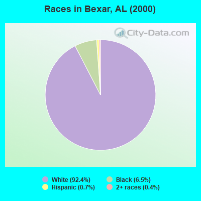
- 1,58292.4%White alone
- 1116.5%Black alone
- 120.7%Hispanic
- 60.4%Two or more races
- 10.06%American Indian alone
- 10.06%Other race alone
 Recent articles from our blog. Our writers, many of them Ph.D. graduates or candidates, create easy-to-read articles on a wide variety of topics.
Current Local Time: CST time zone
Elevation: 518 feet
Land area: 105.3 square miles.
Population density: 15 people per square mile (very low).

| Bexar CCD: | 0.4% ($199) |
| Alabama: | 0.4% ($289) |
Nearest city with pop. 50,000+: Decatur, AL  (68.7 miles , pop. 53,929).
Nearest city with pop. 200,000+: Birmingham, AL (89.1 miles , pop. 242,820).
Nearest city with pop. 1,000,000+: Dallas, TX (509.9 miles , pop. 1,188,580).
Nearest cities:
), ), Latitude: 34.23 N, Longitude: 88.11 W

| Here: | 2.9% |
| Alabama: | 2.6% |
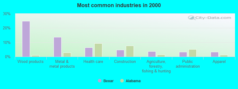
- Wood products (24.7%)
- Metal & metal products (13.6%)
- Health care (6.3%)
- Construction (4.7%)
- Agriculture, forestry, fishing & hunting (3.6%)
- Public administration (3.2%)
- Apparel (3.2%)
- Wood products (27.8%)
- Metal & metal products (21.1%)
- Construction (8.0%)
- Agriculture, forestry, fishing & hunting (4.7%)
- Truck transportation (4.0%)
- Administrative & support & waste management services (3.8%)
- Repair & maintenance (3.6%)
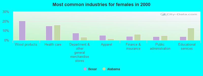
- Wood products (20.5%)
- Health care (15.2%)
- Department & other general merchandise stores (7.8%)
- Apparel (5.3%)
- Finance & insurance (4.3%)
- Public administration (4.0%)
- Educational services (4.0%)
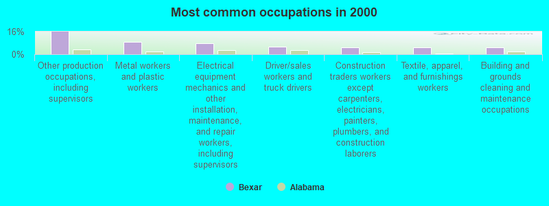
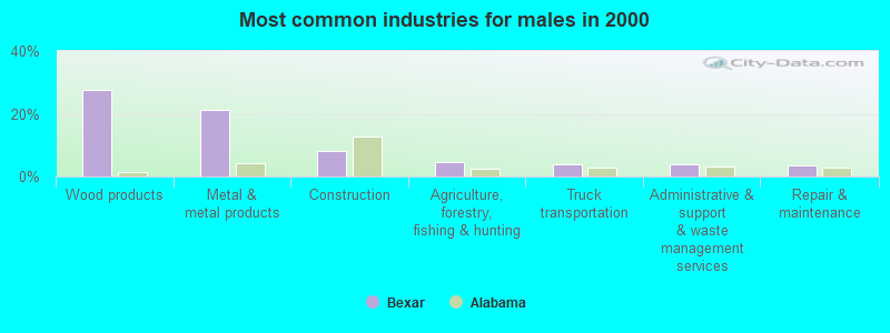
- Other production occupations, including supervisors (15.8%)
- Metal workers and plastic workers (8.8%)
- Electrical equipment mechanics and other installation, maintenance, and repair workers, including supervisors (7.6%)
- Driver/sales workers and truck drivers (5.2%)
- Construction traders workers except carpenters, electricians, painters, plumbers, and construction laborers (5.1%)
- Textile, apparel, and furnishings workers (4.9%)
- Building and grounds cleaning and maintenance occupations (4.8%)
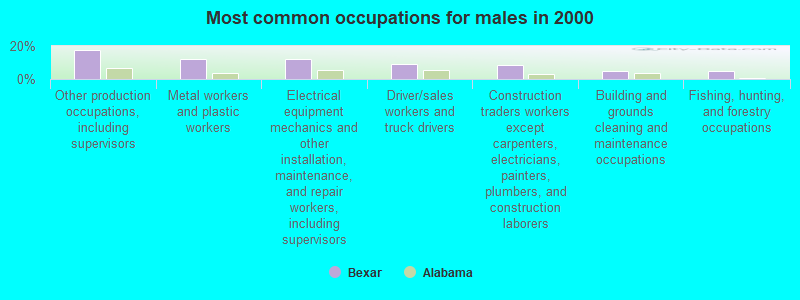
- Other production occupations, including supervisors (17.8%)
- Metal workers and plastic workers (12.2%)
- Electrical equipment mechanics and other installation, maintenance, and repair workers, including supervisors (12.0%)
- Driver/sales workers and truck drivers (8.9%)
- Construction traders workers except carpenters, electricians, painters, plumbers, and construction laborers (8.7%)
- Building and grounds cleaning and maintenance occupations (4.7%)
- Fishing, hunting, and forestry occupations (4.7%)
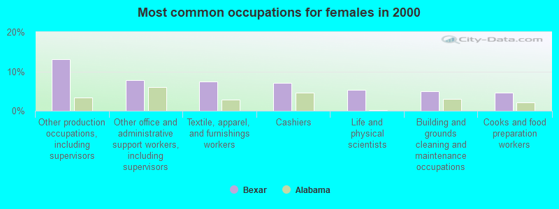
- Other production occupations, including supervisors (13.0%)
- Other office and administrative support workers, including supervisors (7.8%)
- Textile, apparel, and furnishings workers (7.5%)
- Cashiers (7.1%)
- Life and physical scientists (5.3%)
- Building and grounds cleaning and maintenance occupations (5.0%)
- Cooks and food preparation workers (4.7%)
Average climate in Bexar, Alabama
Based on data reported by over 4,000 weather stations


Tornado activity:
Bexar-area historical tornado activity is slightly above Alabama state average. It is 125% greater than the overall U.S. average.
On 4/3/1974, a category F5 (max. wind speeds 261-318 mph) tornado 27.8 miles away from the Bexar place center killed 28 people and injured 272 people.
On 4/3/1974, a category F5 tornado 39.6 miles away from the place center killed 28 people and injured 267 people.
Earthquake activity:
Bexar-area historical earthquake activity is significantly above Alabama state average. It is 220% greater than the overall U.S. average.On 1/18/1999 at 07:00:53, a magnitude 4.8 (4.8 MB, 4.0 LG, Depth: 0.6 mi, Class: Light, Intensity: IV - V) earthquake occurred 75.4 miles away from the city center
On 6/24/1975 at 11:11:36, a magnitude 4.5 (4.5 MB) earthquake occurred 38.7 miles away from the city center
On 3/25/1976 at 00:41:20, a magnitude 5.0 (4.9 MB, 5.0 LG, Class: Moderate, Intensity: VI - VII) earthquake occurred 158.9 miles away from the city center
On 4/29/2003 at 08:59:39, a magnitude 4.9 (4.4 MB, 4.6 MW, 4.9 LG) earthquake occurred 142.8 miles away from Bexar center
On 5/4/1991 at 01:18:54, a magnitude 5.0 (4.4 MB, 4.6 LG, 5.0 LG, Depth: 3.1 mi) earthquake occurred 188.0 miles away from the city center
On 4/27/1989 at 16:47:49, a magnitude 4.7 (4.6 MB, 4.7 LG, 4.3 LG) earthquake occurred 154.5 miles away from Bexar center
Magnitude types: regional Lg-wave magnitude (LG), body-wave magnitude (MB), moment magnitude (MW)
Natural disasters:
The number of natural disasters in Marion County (21) is greater than the US average (15).Major Disasters (Presidential) Declared: 13
Emergencies Declared: 5
Causes of natural disasters: Storms: 11, Tornadoes: 10, Floods: 9, Hurricanes: 4, Winds: 4, Drought: 1, Freeze: 1, Ice Storm: 1, Snowfall: 1, Winter Storm: 1, Other: 1 (Note: some incidents may be assigned to more than one category).
Hospitals and medical centers near Bexar:
- FMC HAMILTON (Dialysis Facility, about 10 miles away; HAMILTON, AL)
- MARION REGIONAL HOMECARE (Home Health Center, about 10 miles away; HAMILTON, AL)
- MARION REGIONAL MEDICAL CENTER Acute Care Hospitals (about 10 miles away; HAMILTON, AL)
- RED BAY NH (Nursing Home, about 14 miles away; RED BAY, AL)
- COMMUNITY HOME CARE (Home Health Center, about 16 miles away; RED BAY, AL)
- RED BAY HOSPITAL Critical Access Hospitals (about 16 miles away; RED BAY, AL)
Colleges/universities with over 2000 students nearest to Bexar:
- Itawamba Community College (about 18 miles; Fulton, MS; Full-time enrollment: 5,489)
- Northeast Mississippi Community College (about 40 miles; Booneville, MS; FT enrollment: 3,024)
- Northwest-Shoals Community College (about 43 miles; Muscle Shoals, AL; FT enrollment: 2,702)
- University of North Alabama (about 47 miles; Florence, AL; FT enrollment: 5,886)
- Mississippi University for Women (about 55 miles; Columbus, MS; FT enrollment: 2,565)
- Bevill State Community College (about 56 miles; Jasper, AL; FT enrollment: 2,970)
- Mississippi State University (about 67 miles; Mississippi State, MS; FT enrollment: 18,237)
Points of interest:
Churches in Bexar include: Rocky Grove Missionary Baptist Church (A), Mount Hope Church (B), Mount Zion Church (C), Pleasant Site Freewill Baptist Church (D), Liberty Hill Freewill Baptist Church (E), Smith Temple Church (F), Shottsville Methodist Church (G), Fairview Freewill Baptist Church (H), Single Spring Church (I). Display/hide their locations on the map
Cemeteries: Bethlehem Cemetery (1), Bexar Cemetery (2), Concord Cemetery (3), Liberty Hill Cemetery (4), Miller Cemetery (5), Donham Cemetery (6), Lockridge Cemetery (7). Display/hide their locations on the map
Reservoir: McRae Lake (A). Display/hide its location on the map
Streams, rivers, and creeks: Rason Branch (A), McConegal Creek (B), Nettles Branch (C), Mule Stable Branch (D), Mill Creek (E), Loyd Mill Branch (F), Little Creek (G), Lane Branch (H), Hurricane Creek (I). Display/hide their locations on the map
| This place: | 2.4 people |
| Alabama: | 2.5 people |
| This place: | 72.3% |
| Whole state: | 67.8% |
| This place: | 3.3% |
| Whole state: | 4.7% |
Likely homosexual households (counted as self-reported same-sex unmarried-partner households)
- Lesbian couples: 0.2% of all households
- Gay men: 0.3% of all households
| This place: | 18.5% |
| Whole state: | 16.1% |
| This place: | 6.9% |
| Whole state: | 7.3% |
For population 15 years and over in Bexar:
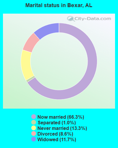
- Never married: 13.3%
- Now married: 66.3%
- Separated: 1.0%
- Widowed: 11.7%
- Divorced: 8.6%
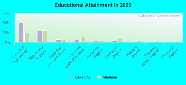
For population 25 years and over in Bexar:
- High school or higher: 50.2%
- Bachelor's degree or higher: 5.1%
- Graduate or professional degree: 1.1%
- Unemployed: 6.0%
- Mean travel time to work (commute): 28.6 minutes
| Here: | 15.1 |
| Alabama average: | 13.2 |
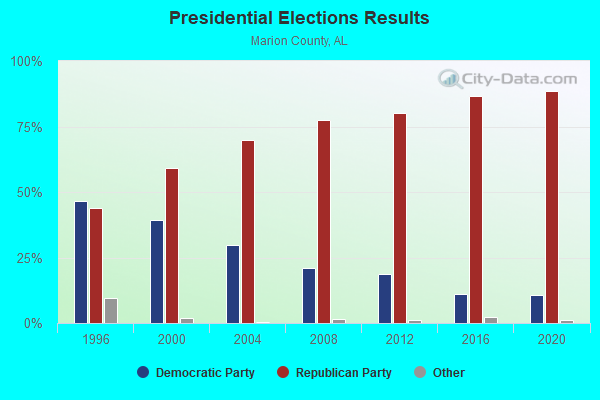
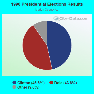
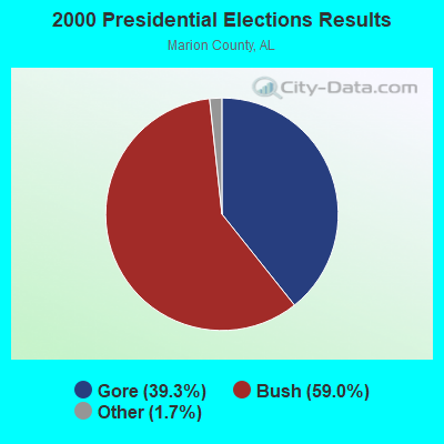
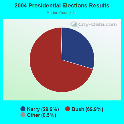
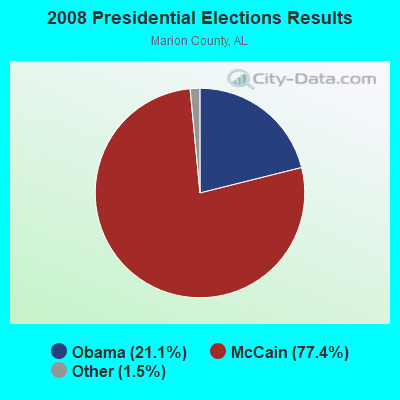
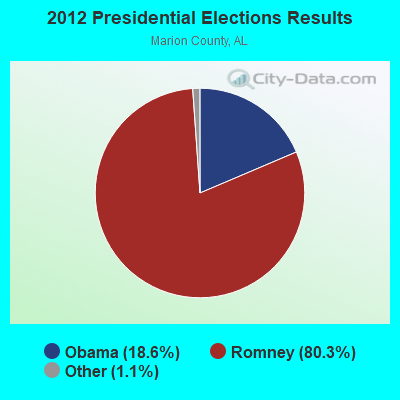

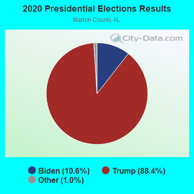
Graphs represent county-level data. Detailed 2008 Election Results
Religion statistics for Bexar, AL (based on Marion County data)
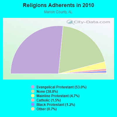
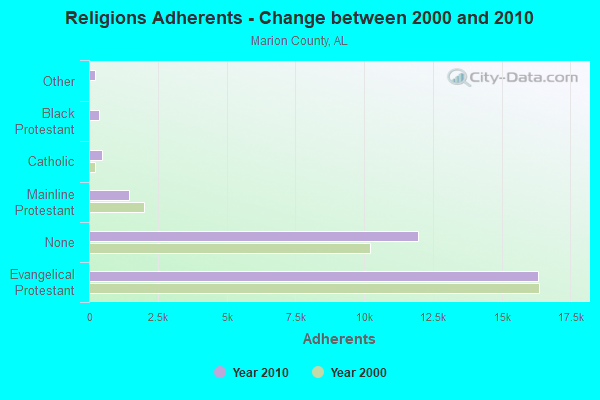
| Religion | Adherents | Congregations |
|---|---|---|
| Evangelical Protestant | 16,308 | 95 |
| Mainline Protestant | 1,460 | 12 |
| Catholic | 474 | 1 |
| Black Protestant | 366 | 3 |
| Other | 220 | 1 |
| None | 11,948 | - |
Food Environment Statistics:
| Marion County: | 1.69 / 10,000 pop. |
| Alabama: | 1.89 / 10,000 pop. |
| Marion County: | 0.34 / 10,000 pop. |
| Alabama: | 0.65 / 10,000 pop. |
| Marion County: | 6.09 / 10,000 pop. |
| Alabama: | 6.32 / 10,000 pop. |
| This county: | 5.75 / 10,000 pop. |
| State: | 5.75 / 10,000 pop. |
| This county: | 11.3% |
| Alabama: | 11.8% |
| Marion County: | 29.3% |
| Alabama: | 31.7% |
| Marion County: | 28.1% |
| State: | 13.5% |
Strongest AM radio stations in Bexar:
- WERH (970 AM; 5 kW; HAMILTON, AL; Owner: KATE F. FITE)
- WCPC (940 AM; 50 kW; HOUSTON, MS; Owner: WCPC BROADCASTING CO., INC.)
- WFTO (1330 AM; 5 kW; FULTON, MS; Owner: AIR SOUTH RADIO, INC.)
- WJOX (690 AM; 50 kW; BIRMINGHAM, AL; Owner: CITADEL BROADCASTING COMPANY)
- WDJC (850 AM; 50 kW; BIRMINGHAM, AL; Owner: KIMTRON, INC.)
- WAPI (1070 AM; 50 kW; BIRMINGHAM, AL; Owner: CITADEL BROADCASTING COMPANY)
- WCRV (640 AM; 50 kW; COLLIERVILLE, TN; Owner: BOTT BROADCASTING COMPANY/TENNESSEE)
- WKXM (1300 AM; 5 kW; WINFIELD, AL; Owner: AD-MEDIA MANAGEMENT CORP.)
- WRMG (1430 AM; 1 kW; RED BAY, AL; Owner: JIMMY R. PYLE)
- WVSA (1380 AM; 5 kW; VERNON, AL; Owner: LAMAR CTY. B/CING. CO., INC.)
- WLOR (1550 AM; 50 kW; HUNTSVILLE, AL; Owner: BCA RADIO, LLC)
- WSM (650 AM; 50 kW; NASHVILLE, TN; Owner: GAYLORD ENTERTAINMENT COMPANY)
- WGSF (1030 AM; 50 kW; MEMPHIS, TN; Owner: FLINN BROADCASTING CORPORATION)
Strongest FM radio stations in Bexar:
- WSYE (93.3 FM; HOUSTON, MS; Owner: JMD, INC.)
- WQLT-FM (107.3 FM; FLORENCE, AL; Owner: BIG RIVER BROADCASTING CORPORATION)
- WFTA (101.9 FM; FULTON, MS; Owner: AIR SOUTH RADIO, INC.)
- WFIX (91.3 FM; FLORENCE, AL; Owner: TRI-STATE INSPIRATIONAL B/C CORP.)
- WKXM-FM (105.9 FM; WINFIELD, AL; Owner: AD-MEDIA MANAGEMENT CORP.)
- WLAY-FM (100.3 FM; TUSCUMBIA, AL; Owner: CLEAR CHANNEL BROADCASTING LICENSES, INC.)
- WXFL (96.1 FM; FLORENCE, AL; Owner: BIG RIVER BROADCASTING CORP.)
- WVNA-FM (105.5 FM; MUSCLE SHOALS, AL; Owner: CLEAR CHANNEL BROADCASTING LICENSES, INC.)
- WBTG-FM (106.3 FM; SHEFFIELD, AL; Owner: SLATTON & ASSOCS. BROADCASTERS, INC.)
- WMXV (103.5 FM; RUSSELLVILLE, AL; Owner: CLEAR CHANNEL BROADCASTING LICENSES, INC.)
- WERH-FM (92.1 FM; HAMILTON, AL; Owner: KATE F. FITE)
- W258AA (99.5 FM; RED BAY, AL; Owner: ROBERT A. TIFFIN)
TV broadcast stations around Bexar:
- WHDF (Channel 15; FLORENCE, AL; Owner: VALLEY TELEVISION, LLC)
- W39CD (Channel 38; FULTON, MS; Owner: UNITY BROADCASTING, INC.)
- WCBI-TV (Channel 4; COLUMBUS, MS; Owner: COLUMBUS TELEVISION, INC.)
- W46DF (Channel 46; HAMILTON, AL; Owner: WMTY, INC.)
- WYLE (Channel 26; FLORENCE, AL; Owner: ETC COMMUNICATIONS INC.)
- WFIQ (Channel 36; FLORENCE, AL; Owner: ALABAMA EDUCATIONAL TELEVISION COMMISSION)
FCC Registered Antenna Towers:
8 (See the full list of FCC Registered Antenna Towers in Bexar)FCC Registered Broadcast Land Mobile Towers:
1- 200 Yds S Of Hwy 78w & 1 Mi W Of Int Al 36 & Hwy 78 (Lat: 34.203722 Lon: -88.171972), Call Sign: WYH230,
Assigned Frequencies: 152.885 MHz, Grant Date: 09/23/1998, Expiration Date: 09/16/2003, Cancellation Date: 11/16/2003, Registrant: Mc Rae Farms, Rt 5, Hamilton, AL 35570, Phone: (205) 921-2639
FCC Registered Microwave Towers:
1- BEXAR, On Us Hwy 78 2 Mi Nw Of (Lat: 34.202306 Lon: -88.185861), Type: Tower, Structure height: 61.9 m, Call Sign: WEG828,
Assigned Frequencies: 6286.19 MHz, 6226.89 MHz, Grant Date: 12/07/2021, Expiration Date: 03/03/2032, Certifier: D J Bolton, Registrant: Keller And Heckman LLP, 1001 G Street, Nw, Suite 500, Washington, DC 20001, Phone: (202) 434-4100, Fax: (202) 434-4646, Email:
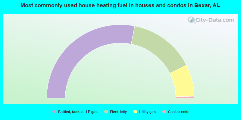
- 56.2%Bottled, tank, or LP gas
- 29.0%Electricity
- 14.0%Utility gas
- 0.8%Coal or coke
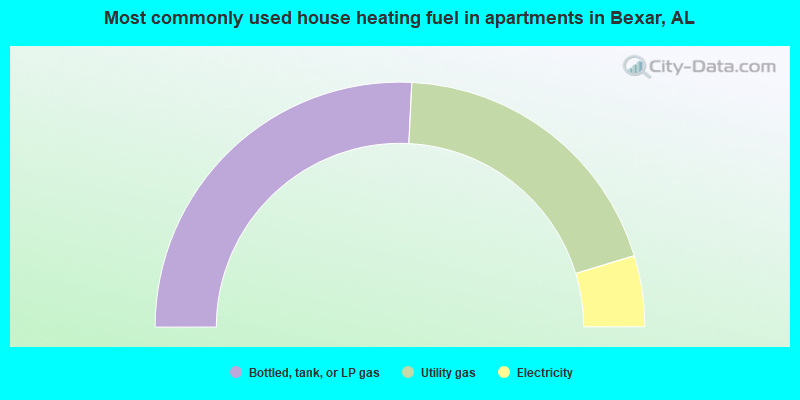
- 51.6%Bottled, tank, or LP gas
- 39.1%Utility gas
- 9.4%Electricity
Bexar compared to Alabama state average:
- Median house value below state average.
- Unemployed percentage below state average.
- Black race population percentage significantly below state average.
- Hispanic race population percentage significantly below state average.
- Median age below state average.
- Foreign-born population percentage significantly below state average.
- Renting percentage significantly below state average.
- Length of stay since moving in significantly above state average.
- Number of rooms per house significantly below state average.
- House age significantly below state average.
- Number of college students below state average.
- Percentage of population with a bachelor's degree or higher significantly below state average.