Bethel, North Carolina
Submit your own pictures of this town and show them to the world
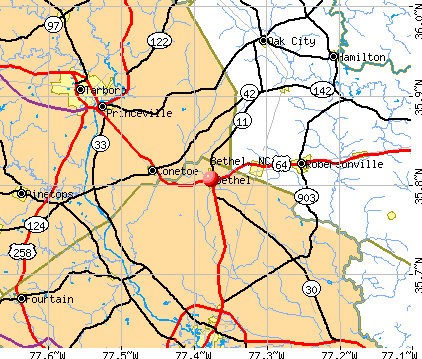
- OSM Map
- General Map
- Google Map
- MSN Map
Population change since 2000: -17.1%
 |
| Males: 623 | |
| Females: 770 |
| Median resident age: | 42.7 years |
| North Carolina median age: | 39.2 years |
Zip codes: 27812.
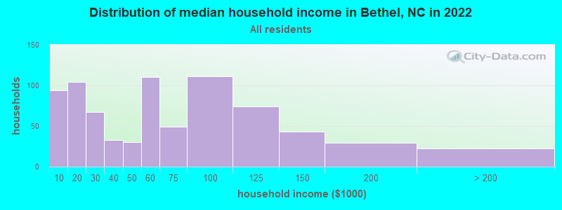
| Bethel: | $53,093 |
| NC: | $67,481 |
Estimated per capita income in 2022: $30,436 (it was $15,219 in 2000)
Bethel town income, earnings, and wages data
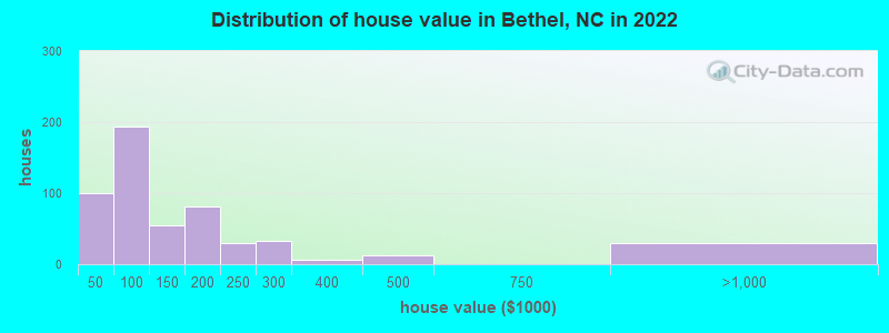
Estimated median house or condo value in 2022: $129,894 (it was $65,200 in 2000)
| Bethel: | $129,894 |
| NC: | $280,600 |
Mean prices in 2022: all housing units: $142,560; detached houses: $147,236; mobile homes: $55,919
Median gross rent in 2022: $706.
(6.1% for White Non-Hispanic residents, 23.5% for Black residents, 25.0% for Hispanic or Latino residents, 100.0% for American Indian residents, 25.0% for other race residents)
Detailed information about poverty and poor residents in Bethel, NC
Compare current foreclosures near Bethel, NC:
| Photo | Address | Area | Beds / Baths | Price | Details |
|---|---|---|---|---|---|

|
#1
Nc Highway 11 N
Bethel, NC 27812
|
1,971 sq. feet
|
2 baths 3 beds |
show details | |

|
#2
Kirkland Dr
Greenville, NC 27858
|
2,673 sq. feet
|
3 baths 3 beds |
$300,000
|
show details |

|
#3
N Maple St
Oak City, NC 27857
|
1,857 sq. feet
|
2 baths 3 beds |
show details | |

|
#4
Us Highway 258 S
Pinetops, NC 27864
|
1,876 sq. feet
|
2 baths 3 beds |
show details | |

|
#5
May St
Greenville, NC 27834
|
1,956 sq. feet
|
1 baths 3 beds |
show details | |

|
#6
Adams Blvd
Greenville, NC 27858
|
1,505 sq. feet
|
1 baths 3 beds |
show details | |

|
#7
Prison Camp Rd
Williamston, NC 27892
|
1,144 sq. feet
|
1 baths 2 beds |
show details | |

|
#8
Prince Rd
Greenville, NC 27858
|
1,837 sq. feet
|
2 baths 3 beds |
show details | |

|
#9
Garner Rd
Greenville, NC 27834
|
1,872 sq. feet
|
2 baths 3 beds |
show details | |

|
#10
Briarcliff Dr
Greenville, NC 27834
|
1,531 sq. feet
|
2 baths 3 beds |
show details |
| Photo | Address | Area | Beds / Baths | Price | Details |
|---|---|---|---|---|---|

|
#11
Briarcliff Dr
Greenville, NC 27834
|
1,574 sq. feet
|
2 baths 3 beds |
show details | |

|
#12
Abbitt Rd
Williamston, NC 27892
|
1,368 sq. feet
|
1 baths 3 beds |
show details | |

|
#13
Bear Grass Rd
Williamston, NC 27892
|
2,057 sq. feet
|
2 baths 3 beds |
show details | |

|
#14
Brunswick Ln
Greenville, NC 27834
|
3,510 sq. feet
|
3 baths 3 beds |
show details | |

|
#15
Bonnie Best Rd
Williamston, NC 27892
|
1,056 sq. feet
|
1 baths 3 beds |
show details | |

|
#16
Sunny Side Rd
Greenville, NC 27834
|
2,254 sq. feet
|
2 baths 3 beds |
show details | |

|
#17
Jackson Dr
Greenville, NC 27858
|
1,722 sq. feet
|
1 baths 3 beds |
show details | |

|
#18
Hasting St
Tarboro, NC 27886
|
1,563 sq. feet
|
1 baths 4 beds |
show details | |

|
#19
Abbey Ln
Greenville, NC 27834
|
1,422 sq. feet
|
2 baths 3 beds |
show details | |

|
#20
Nc Highway 111 And 122 S
Tarboro, NC 27886
|
1,080 sq. feet
|
2 baths 3 beds |
show details |
| Photo | Address | Area | Beds / Baths | Price | Details |
|---|---|---|---|---|---|

|
#21
Dawson St
Greenville, NC 27834
|
1,025 sq. feet
|
1 baths 3 beds |
show details | |

|
#22
Dickinson Ave # B
Greenville, NC 27834
|
2,368 sq. feet
|
2 baths 5 beds |
show details | |

|
#23
N Village Dr
Greenville, NC 27834
|
1,663 sq. feet
|
1 baths 5 beds |
show details | |

|
#24
Kings Crossroads Rd
Greenville, NC 27834
|
1,170 sq. feet
|
1 baths 4 beds |
show details | |

|
#25
Nc Highway 111 And 122 S
Tarboro, NC 27886
|
2,220 sq. feet
|
2 baths 3 beds |
show details | |

|
#26
Williamsburg Dr
Tarboro, NC 27886
|
2,336 sq. feet
|
2 baths 3 beds |
show details | |

|
#27
Scarlett Ohara Rd
Greenville, NC 27834
|
1,944 sq. feet
|
2 baths 4 beds |
show details | |

|
#28
Bailey Rd
Williamston, NC 27892
|
1,792 sq. feet
|
2 baths 3 beds |
show details | |

|
#29
Rhett Butler Rd
Greenville, NC 27834
|
2,052 sq. feet
|
2 baths 4 beds |
show details | |

|
#30
Edwards St
Greenville, NC 27858
|
1,078 sq. feet
|
1 baths 2 beds |
show details |
| Photo | Address | Area | Beds / Baths | Price | Details |
|---|---|---|---|---|---|

|
#31
Webb St
Greenville, NC 27834
|
1,110 sq. feet
|
1 baths 3 beds |
show details | |

|
#32
Sunset Ave
Tarboro, NC 27886
|
1,168 sq. feet
|
1 baths 2 beds |
show details | |

|
#33
Landing Cir
Grimesland, NC 27837
|
2,452 sq. feet
|
2 baths 4 beds |
show details | |

|
#34
Keagan Way
Grimesland, NC 27837
|
1,273 sq. feet
|
2 baths 3 beds |
show details | |

|
#35
Cedarhurst Rd
Greenville, NC 27834
|
2,132 sq. feet
|
2 baths 3 beds |
show details | |

|
#36
Christopher Dr
Greenville, NC 27858
|
1,619 sq. feet
|
2 baths 3 beds |
show details | |

|
#37
Springhill Rd
Greenville, NC 27858
|
1,475 sq. feet
|
1 baths 3 beds |
show details | |

|
#38
Deer Walk
Tarboro, NC 27886
|
1,243 sq. feet
|
2 baths 3 beds |
show details | |

|
#39
Tucker Rd
Grimesland, NC 27837
|
1,512 sq. feet
|
2 baths 3 beds |
show details | |

|
#40
Louis St
Greenville, NC 27858
|
1,720 sq. feet
|
2 baths 3 beds |
show details |
| Photo | Address | Area | Beds / Baths | Price | Details |
|---|---|---|---|---|---|

|
#41
Hillendale Cir
Greenville, NC 27858
|
1,330 sq. feet
|
1 baths 3 beds |
show details | |

|
#42
Arbor Dr
Greenville, NC 27858
|
1,853 sq. feet
|
3 baths 4 beds |
show details | |

|
#43
Greenville Blvd SW
Greenville, NC 27834
|
1,792 sq. feet
|
1 baths 3 beds |
show details | |

|
#44
Rollins Dr Apt 16
Greenville, NC 27834
|
1,305 sq. feet
|
2 baths 3 beds |
show details | |

|
#45
Autumn Dr
Greenville, NC 27834
|
1,270 sq. feet
|
2 baths 3 beds |
show details | |

|
#46
Ruth Ct
Greenville, NC 27834
|
1,247 sq. feet
|
2 baths 3 beds |
show details | |

|
#47
Tall Oaks Rd
Tarboro, NC 27886
|
856 sq. feet
|
1 baths 2 beds |
show details | |

|
#48
Saint Andrews Dr
Greenville, NC 27834
|
1,656 sq. feet
|
2 baths 3 beds |
show details | |

|
#49
Nc Highway 97 E
Tarboro, NC 27886
|
1,067 sq. feet
|
1 baths 3 beds |
show details | |

|
Check over 1 million property listings on Foreclosure.com!
|
browse all offers | |||


- 92256.7%Black alone
- 64139.4%White alone
- 553.4%Two or more races
- 161.0%Hispanic
- 10.06%American Indian alone
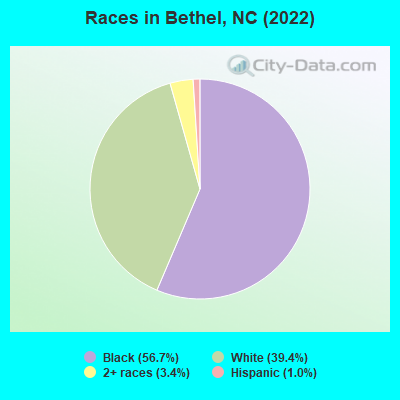
Races in Bethel detailed stats: ancestries, foreign born residents, place of birth
According to our research of North Carolina and other state lists, there were 7 registered sex offenders living in Bethel, North Carolina as of May 21, 2024.
The ratio of all residents to sex offenders in Bethel is 235 to 1.
Type |
2009 |
2010 |
2012 |
2013 |
2014 |
2015 |
2016 |
|---|---|---|---|---|---|---|---|
| Murders (per 100,000) | 0 (0.0) | 0 (0.0) | 0 (0.0) | 1 (61.5) | 0 (0.0) | 0 (0.0) | 0 (0.0) |
| Rapes (per 100,000) | 0 (0.0) | 0 (0.0) | 1 (61.6) | 0 (0.0) | 0 (0.0) | 0 (0.0) | 0 (0.0) |
| Robberies (per 100,000) | 2 (114.9) | 2 (126.8) | 2 (123.2) | 1 (61.5) | 1 (61.5) | 0 (0.0) | 1 (61.4) |
| Assaults (per 100,000) | 6 (344.6) | 2 (126.8) | 10 (616.1) | 3 (184.6) | 6 (368.8) | 1 (61.3) | 4 (245.7) |
| Burglaries (per 100,000) | 1 (57.4) | 4 (253.6) | 5 (308.1) | 1 (61.5) | 2 (122.9) | 1 (61.3) | 5 (307.1) |
| Thefts (per 100,000) | 46 (2,642) | 30 (1,902) | 44 (2,711) | 44 (2,708) | 34 (2,090) | 10 (612.7) | 16 (982.8) |
| Auto thefts (per 100,000) | 3 (172.3) | 0 (0.0) | 2 (123.2) | 2 (123.1) | 2 (122.9) | 0 (0.0) | 1 (61.4) |
| Arson (per 100,000) | 1 (57.4) | 1 (63.4) | 0 (0.0) | 1 (61.5) | 0 (0.0) | 0 (0.0) | 0 (0.0) |
| City-Data.com crime index | 226.9 | 157.3 | 349.4 | 300.9 | 194.2 | 41.1 | 133.3 |
The City-Data.com crime index weighs serious crimes and violent crimes more heavily. Higher means more crime, U.S. average is 246.1. It adjusts for the number of visitors and daily workers commuting into cities.
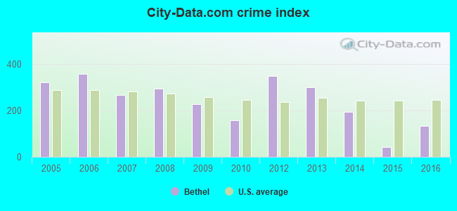
Crime rate in Bethel detailed stats: murders, rapes, robberies, assaults, burglaries, thefts, arson
Full-time law enforcement employees in 2021, including police officers: 3 (3 officers - 3 male; 0 female).
| Officers per 1,000 residents here: | 1.86 |
| North Carolina average: | 2.27 |
 Recent articles from our blog. Our writers, many of them Ph.D. graduates or candidates, create easy-to-read articles on a wide variety of topics.


 | Excavation/Grading in Haywood County (3 replies) |
| Towns between Raleigh and Greensville, NC (18 replies) |
| NC governor orders Confederate monuments removed at Capitol after statues toppled (146 replies) |
| North Carolina development thread. (5147 replies) |
| Greensboro Beltway (I-85, I-73, I-840, I-785) (245 replies) |
| Carolina Bays Parkway extension into North Carolina (34 replies) |
Latest news from Bethel, NC collected exclusively by city-data.com from local newspapers, TV, and radio stations
Ancestries: English (13.0%), European (10.7%), American (8.1%), Irish (2.0%).
Current Local Time: EST time zone
Land area: 1.05 square miles.
Population density: 1,331 people per square mile (low).
11 residents are foreign born
| This town: | 0.7% |
| North Carolina: | 8.3% |
Median real estate property taxes paid for housing units with mortgages in 2022: $1,516 (0.9%)
Median real estate property taxes paid for housing units with no mortgage in 2022: $1,295 (1.3%)
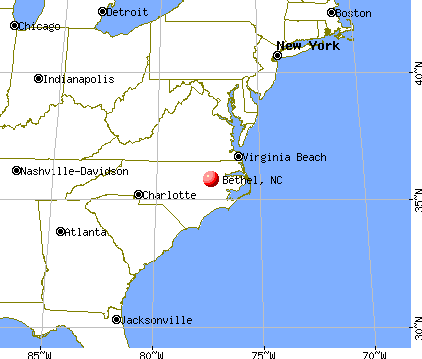
Nearest city with pop. 50,000+: Greenville, NC  (14.2 miles , pop. 60,476).
Nearest city with pop. 200,000+: Raleigh, NC (71.1 miles , pop. 276,093).
Nearest city with pop. 1,000,000+: Philadelphia, PA (314.4 miles , pop. 1,517,550).
Nearest cities:
), ), ), ), ), ), Latitude: 35.81 N, Longitude: 77.38 W
Area code: 252
Property values in Bethel, NC
| Here: | 3.6% |
| North Carolina: | 3.2% |
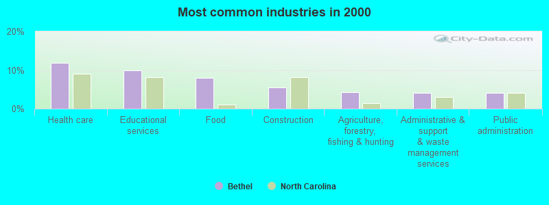
- Health care (11.9%)
- Educational services (9.8%)
- Food (8.0%)
- Construction (5.5%)
- Agriculture, forestry, fishing & hunting (4.2%)
- Administrative & support & waste management services (4.0%)
- Public administration (4.0%)
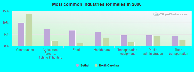
- Construction (10.1%)
- Agriculture, forestry, fishing & hunting (7.4%)
- Food (6.7%)
- Health care (6.0%)
- Transportation equipment (4.7%)
- Public administration (4.7%)
- Truck transportation (4.4%)
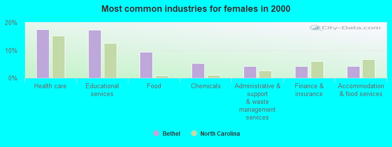
- Health care (17.6%)
- Educational services (17.3%)
- Food (9.3%)
- Chemicals (5.3%)
- Administrative & support & waste management services (4.3%)
- Finance & insurance (4.3%)
- Accommodation & food services (4.3%)
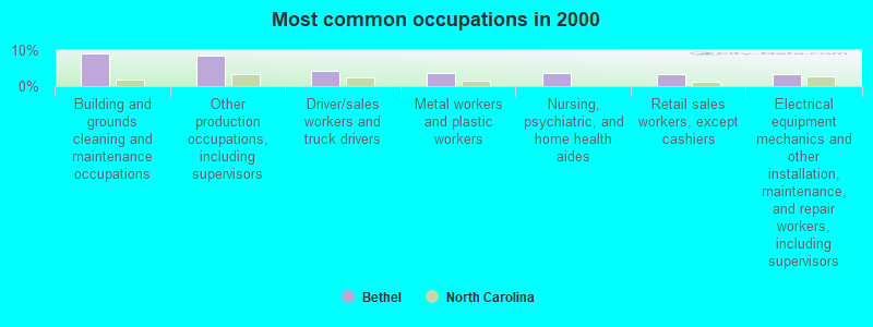
- Building and grounds cleaning and maintenance occupations (9.0%)
- Other production occupations, including supervisors (8.3%)
- Driver/sales workers and truck drivers (4.3%)
- Metal workers and plastic workers (3.7%)
- Nursing, psychiatric, and home health aides (3.7%)
- Retail sales workers, except cashiers (3.3%)
- Electrical equipment mechanics and other installation, maintenance, and repair workers, including supervisors (3.3%)
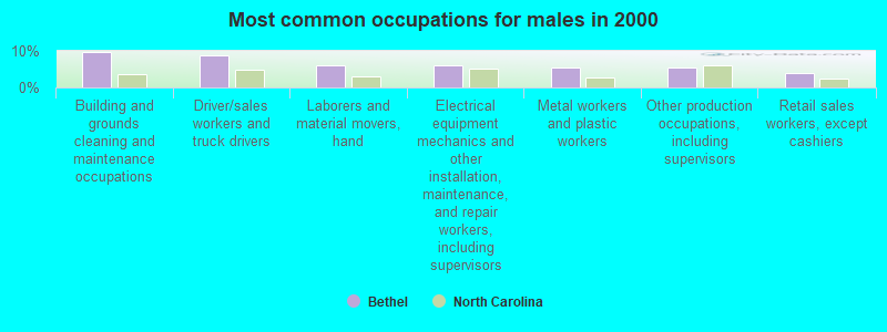
- Building and grounds cleaning and maintenance occupations (9.7%)
- Driver/sales workers and truck drivers (8.7%)
- Laborers and material movers, hand (6.0%)
- Electrical equipment mechanics and other installation, maintenance, and repair workers, including supervisors (6.0%)
- Metal workers and plastic workers (5.4%)
- Other production occupations, including supervisors (5.4%)
- Retail sales workers, except cashiers (4.0%)
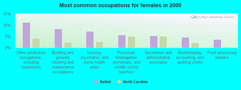
- Other production occupations, including supervisors (11.3%)
- Building and grounds cleaning and maintenance occupations (8.3%)
- Nursing, psychiatric, and home health aides (7.3%)
- Preschool, kindergarten, elementary, and middle school teachers (5.6%)
- Secretaries and administrative assistants (5.3%)
- Bookkeeping, accounting, and auditing clerks (4.7%)
- Food processing workers (3.7%)
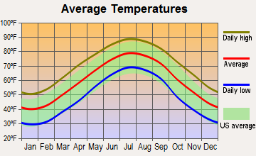
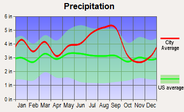
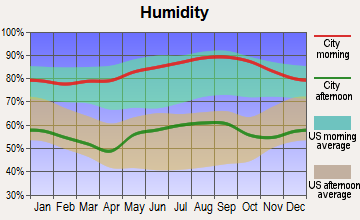
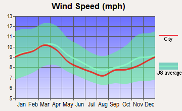
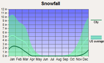
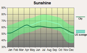
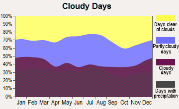
Average climate in Bethel, North Carolina
Based on data reported by over 4,000 weather stations
|
|

(lower is better)
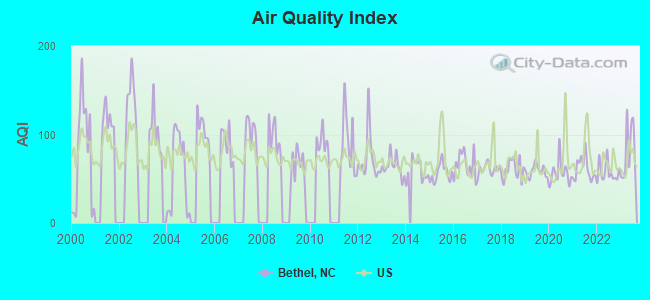
Air Quality Index (AQI) level in 2023 was 80.3. This is about average.
| City: | 80.3 |
| U.S.: | 72.6 |
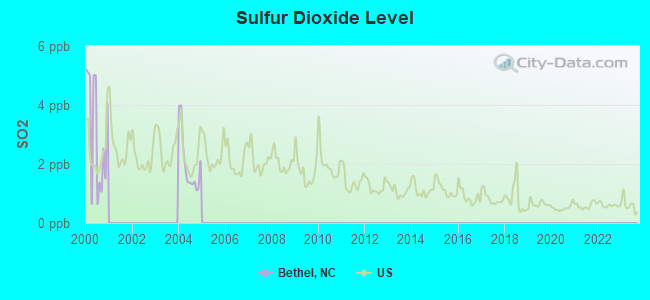
Sulfur Dioxide (SO2) [ppb] level in 2004 was 2.00. This is worse than average. Closest monitor was 12.9 miles away from the city center.
| City: | 2.00 |
| U.S.: | 1.51 |
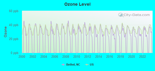
Ozone [ppb] level in 2022 was 28.5. This is about average. Closest monitor was 11.5 miles away from the city center.
| City: | 28.5 |
| U.S.: | 33.3 |
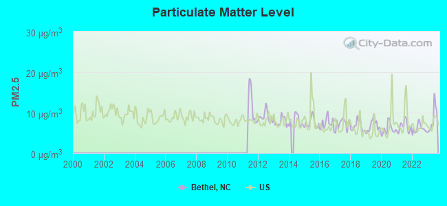
Particulate Matter (PM2.5) [µg/m3] level in 2023 was 8.29. This is about average. Closest monitor was 11.5 miles away from the city center.
| City: | 8.29 |
| U.S.: | 8.11 |
Tornado activity:
Bethel-area historical tornado activity is slightly above North Carolina state average. It is 7% greater than the overall U.S. average.
On 3/28/1984, a category F4 (max. wind speeds 207-260 mph) tornado 13.3 miles away from the Bethel town center killed 16 people and injured 153 people and caused between $5,000,000 and $50,000,000 in damages.
On 3/15/1953, a category F3 (max. wind speeds 158-206 mph) tornado 11.5 miles away from the town center injured one person and caused between $50,000 and $500,000 in damages.
Earthquake activity:
Bethel-area historical earthquake activity is significantly above North Carolina state average. It is 59% smaller than the overall U.S. average.On 8/23/2011 at 17:51:04, a magnitude 5.8 (5.8 MW, Depth: 3.7 mi, Class: Moderate, Intensity: VI - VII) earthquake occurred 148.7 miles away from the city center
On 8/9/2020 at 12:07:37, a magnitude 5.1 (5.1 MW, Depth: 4.7 mi) earthquake occurred 212.7 miles away from the city center
On 12/9/2003 at 20:59:14, a magnitude 4.5 (4.5 MB, 4.5 LG, Class: Light, Intensity: IV - V) earthquake occurred 126.5 miles away from the city center
On 12/9/2003 at 20:59:18, a magnitude 4.5 (4.5 ML, Depth: 6.2 mi) earthquake occurred 141.8 miles away from the city center
On 8/25/2011 at 05:07:52, a magnitude 4.5 (4.5 ML, Depth: 4.2 mi) earthquake occurred 151.6 miles away from the city center
On 8/6/1994 at 19:54:09, a magnitude 3.8 (3.6 LG, 3.8 LG, Depth: 3.1 mi, Class: Light, Intensity: II - III) earthquake occurred 62.2 miles away from Bethel center
Magnitude types: regional Lg-wave magnitude (LG), body-wave magnitude (MB), local magnitude (ML), moment magnitude (MW)
Natural disasters:
The number of natural disasters in Pitt County (22) is greater than the US average (15).Major Disasters (Presidential) Declared: 12
Emergencies Declared: 6
Causes of natural disasters: Hurricanes: 16, Storms: 3, Floods: 2, Tornadoes: 2, Blizzard: 1, Ice Storm: 1, Tropical Storm: 1, Wind: 1, Other: 1 (Note: some incidents may be assigned to more than one category).
Hospitals and medical centers near Bethel:
- THE FOUNTAINS AT THE ALBEMARLE (Nursing Home, about 11 miles away; TARBORO, NC)
- SKILL CREATIONS OF TARBORO (Hospital, about 12 miles away; TARBORO, NC)
- TARBORO NURSING CENTER (Nursing Home, about 12 miles away; TARBORO, NC)
- WESTGATE NURSING CENTER OF TARBORO (Nursing Home, about 12 miles away; TARBORO, NC)
- BEVERLY HEALTH CARE CTR (Nursing Home, about 12 miles away; TARBORO, NC)
- GOLDEN LIVINGCENTER - TARBORO (Nursing Home, about 12 miles away; TARBORO, NC)
- VIDANT EDGECOMBE HOSPITAL Acute Care Hospitals (about 13 miles away; TARBORO, NC)
Colleges/universities with over 2000 students nearest to Bethel:
- Edgecombe Community College (about 13 miles; Tarboro, NC; Full-time enrollment: 2,058)
- East Carolina University (about 14 miles; Greenville, NC; FT enrollment: 23,943)
- Pitt Community College (about 18 miles; Winterville, NC; FT enrollment: 7,026)
- Nash Community College (about 32 miles; Rocky Mount, NC; FT enrollment: 2,520)
- Lenoir Community College (about 42 miles; Kinston, NC; FT enrollment: 2,555)
- Wayne Community College (about 43 miles; Goldsboro, NC; FT enrollment: 3,174)
- Craven Community College (about 51 miles; New Bern, NC; FT enrollment: 2,712)
Public high school in Bethel:
- NORTH PITT HIGH (Location: 5659 NC 11 NORTH, Grades: 9-12)
Public elementary/middle school in Bethel:
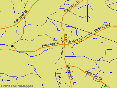
Points of interest:
Notable locations in Bethel: Town Hall (A), Bethel Police Department (B). Display/hide their locations on the map
Drinking water stations with addresses in Bethel and their reported violations in the past:
BETHEL, TOWN OF (Population served: 1,640, Purch surface water):Past monitoring violations:
- Monitoring and Reporting (DBP) - Between JAN-2014 and MAR-2014, Contaminant: Total Haloacetic Acids (HAA5). Follow-up actions: St AO (w/o penalty) issued (JUN-13-2014), St Public Notif requested (JUN-13-2014), St Formal NOV issued (JUN-13-2014)
- Monitoring and Reporting (DBP) - Between OCT-2013 and DEC-2013, Contaminant: TTHM. Follow-up actions: St AO (w/o penalty) issued (FEB-19-2014), St Formal NOV issued (FEB-19-2014), St Public Notif requested (FEB-19-2014), St AO (w/penalty) issued (JUN-10-2014)
- Monitoring and Reporting (DBP) - Between OCT-2013 and DEC-2013, Contaminant: Total Haloacetic Acids (HAA5). Follow-up actions: St AO (w/o penalty) issued (FEB-19-2014), St Formal NOV issued (FEB-19-2014), St Public Notif requested (FEB-19-2014), St AO (w/penalty) issued (JUN-10-2014)
- Monitoring and Reporting (DBP) - Between JAN-2013 and MAR-2013, Contaminant: Chlorine. Follow-up actions: St Public Notif received (MAR-01-2013), St Compliance achieved (JUN-01-2013), St Public Notif requested (JUN-05-2013), St AO (w/o penalty) issued (JUN-05-2013), St Formal NOV issued (JUN-05-2013)
- Monitoring and Reporting (DBP) - Between JAN-2012 and MAR-2012, Contaminant: Chlorine. Follow-up actions: St Public Notif requested (MAY-03-2012), St Formal NOV issued (MAY-03-2012), St AO (w/o penalty) issued (MAY-03-2012), St Compliance achieved (AUG-01-2012), St Public Notif received (MAR-01-2013)
- 2 routine major monitoring violations
- One other older monitoring violation
| This town: | 2.4 people |
| North Carolina: | 2.5 people |
| This town: | 64.2% |
| Whole state: | 66.7% |
| This town: | 5.6% |
| Whole state: | 5.9% |
Likely homosexual households (counted as self-reported same-sex unmarried-partner households)
- Lesbian couples: 0.3% of all households
- Gay men: 0.8% of all households
5 people in homes for the mentally ill in 2000
Banks with branches in Bethel (2011 data):
- Southern Bank and Trust Company: Bethel Branch at 7458 Main Street, branch established on 1986/08/18. Info updated 2011/09/26: Bank assets: $2,039.8 mil, Deposits: $1,658.5 mil, headquarters in Mount Olive, NC, positive income, Commercial Lending Specialization, 66 total offices, Holding Company: Southern Bancshares (N.C.), Inc.
- Carter Bank & Trust: Bethel Branch at 122 West Andrews Street, branch established on 2002/06/14. Info updated 2007/02/23: Bank assets: $3,970.4 mil, Deposits: $3,610.0 mil, headquarters in Martinsville, VA, positive income, Commercial Lending Specialization, 123 total offices
For population 15 years and over in Bethel:
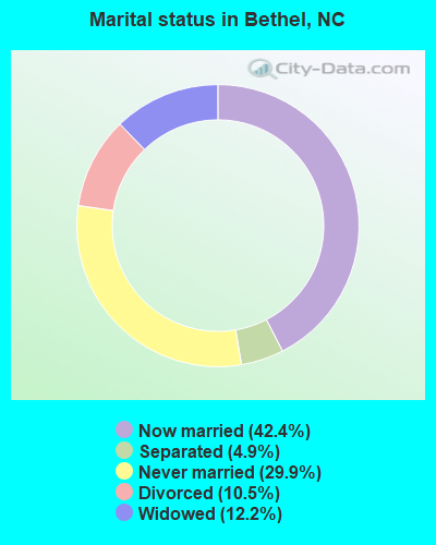
- Never married: 29.9%
- Now married: 42.4%
- Separated: 4.9%
- Widowed: 12.2%
- Divorced: 10.5%
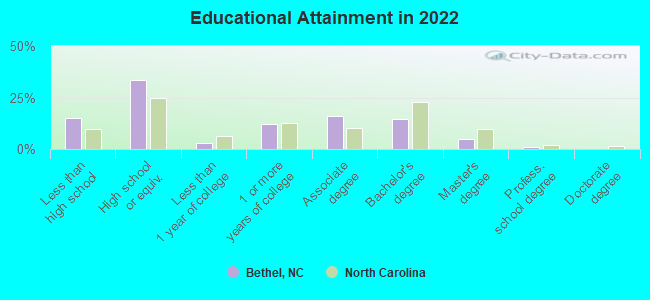
For population 25 years and over in Bethel:
- High school or higher: 84.2%
- Bachelor's degree or higher: 19.1%
- Graduate or professional degree: 5.1%
- Unemployed: 8.1%
- Mean travel time to work (commute): 24.0 minutes
| Here: | 10.3 |
| North Carolina average: | 11.7 |
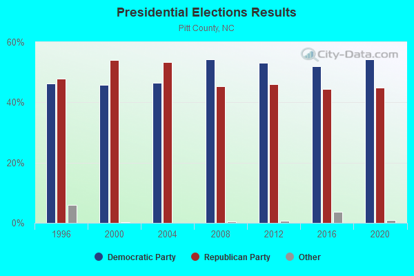
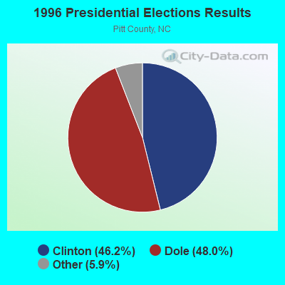
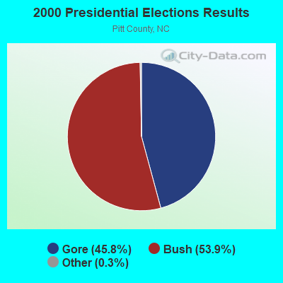
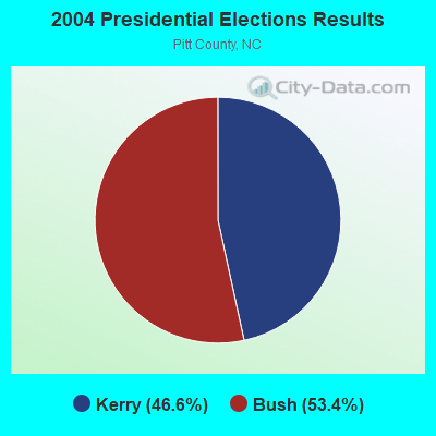
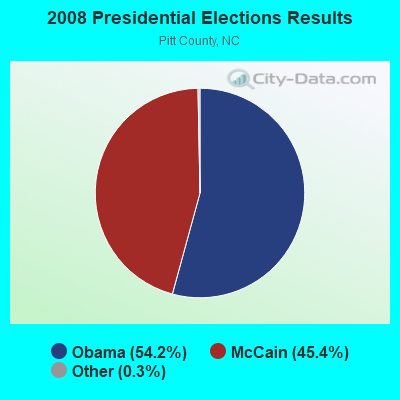
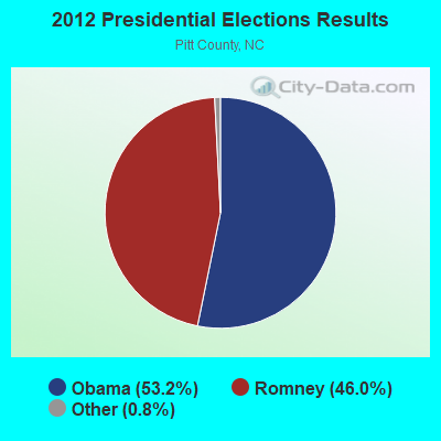
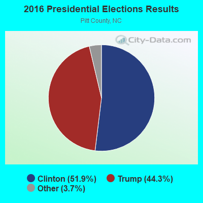

Graphs represent county-level data. Detailed 2008 Election Results
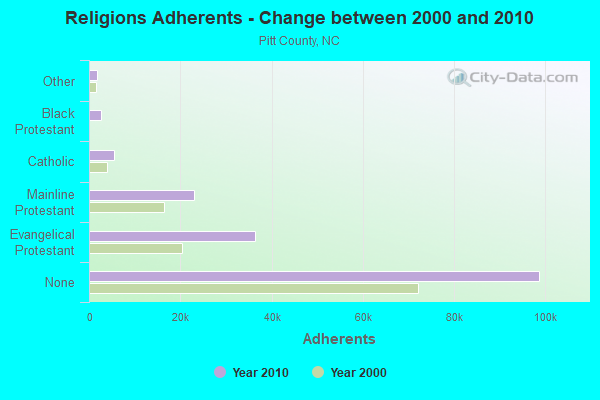
Religion statistics for Bethel, NC (based on Pitt County data)
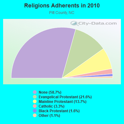
| Religion | Adherents | Congregations |
|---|---|---|
| Evangelical Protestant | 36,334 | 154 |
| Mainline Protestant | 23,029 | 47 |
| Catholic | 5,489 | 3 |
| Black Protestant | 2,712 | 32 |
| Other | 1,855 | 11 |
| Orthodox | 50 | 1 |
| None | 98,679 | - |
Food Environment Statistics:
| Here: | 1.91 / 10,000 pop. |
| North Carolina: | 2.05 / 10,000 pop. |
| This county: | 0.13 / 10,000 pop. |
| North Carolina: | 0.14 / 10,000 pop. |
| Here: | 0.85 / 10,000 pop. |
| State: | 0.92 / 10,000 pop. |
| Pitt County: | 4.54 / 10,000 pop. |
| North Carolina: | 4.75 / 10,000 pop. |
| This county: | 6.70 / 10,000 pop. |
| State: | 7.57 / 10,000 pop. |
| Pitt County: | 9.6% |
| State: | 9.8% |
| Pitt County: | 32.2% |
| North Carolina: | 28.3% |
| Here: | 15.9% |
| State: | 15.6% |
Health and Nutrition:
| Bethel: | 49.6% |
| North Carolina: | 48.9% |
| Here: | 45.9% |
| North Carolina: | 46.1% |
| Bethel: | 29.8 |
| State: | 28.8 |
| Here: | 19.1% |
| State: | 20.7% |
| Here: | 13.1% |
| North Carolina: | 10.7% |
| Bethel: | 6.7 |
| North Carolina: | 6.8 |
| This city: | 37.6% |
| State: | 33.7% |
| Bethel: | 53.7% |
| North Carolina: | 55.8% |
| Bethel: | 80.2% |
| North Carolina: | 79.7% |
More about Health and Nutrition of Bethel, NC Residents
| Local government employment and payroll (March 2022) | |||||
| Function | Full-time employees | Monthly full-time payroll | Average yearly full-time wage | Part-time employees | Monthly part-time payroll |
|---|---|---|---|---|---|
| Police Protection - Officers | 3 | $8,942 | $35,768 | 0 | $0 |
| Other Government Administration | 0 | $0 | 6 | $2,772 | |
| Totals for Government | 3 | $8,942 | $35,768 | 6 | $2,772 |
Strongest AM radio stations in Bethel:
- WNCT (1070 AM; 10 kW; GREENVILLE, NC; Owner: WNCT LICENSE LIMITED PARTNERSHIP)
- WGHB (1250 AM; 5 kW; FARMVILLE, NC; Owner: CONNER MEDIA, INC.)
- WPTF (680 AM; 50 kW; RALEIGH, NC; Owner: FIRST STATE COMMUNICATIONS)
- WDLX (930 AM; 5 kW; WASHINGTON, NC; Owner: NM LICENSING, LLC)
- WYAL (1280 AM; daytime; 5 kW; SCOTLAND NECK, NC)
- WFTK (1030 AM; daytime; 50 kW; WAKE FOREST, NC; Owner: POSITIVE RADIO GROUP, INC.)
- WCPS (760 AM; daytime; 1 kW; TARBORO, NC; Owner: JOHNSON BROADCAST VENTURES, LTD)
- WTAR (850 AM; 50 kW; NORFOLK, VA; Owner: SINCLAIR COMMUNICATIONS)
- WCKO (1110 AM; daytime; 50 kW; NORFOLK, VA; Owner: WORD BROADCASTING NETWORK, INC.)
- WGTM (590 AM; 5 kW; WILSON, NC; Owner: SPIRIT BROADCASTING, INC.)
- WEED (1390 AM; 5 kW; ROCKY MOUNT, NC; Owner: NORTHSTAR BROADCATING CORPORATION)
- WOOW (1340 AM; 1 kW; GREENVILLE, NC; Owner: THE MINORITY VOICE, INC.)
- WETC (540 AM; 8 kW; WENDELL-ZEBULON, NC; Owner: CAROLINA REGIONAL BROADCASTING CORPORATION)
Strongest FM radio stations in Bethel:
- WTRG (100.7 FM; ROCKY MOUNT, NC; Owner: CAPSTAR TX LIMITED PARTNERSHIP)
- WERO (93.3 FM; WASHINGTON, NC; Owner: NM LICENSING, LLC)
- WNCT-FM (107.9 FM; GREENVILLE, NC; Owner: WNCT LICENSE LIMITED PARTNERSHIP)
- WFXK (104.3 FM; TARBORO, NC; Owner: RADIO ONE LICENSES, LLC)
- WCBZ (103.7 FM; WILLIAMSTON, NC; Owner: ABG NORTH CAROLINA, LLC)
- WGPM (94.3 FM; FARMVILLE, NC; Owner: ABG NORTH CAROLINA, LLC)
- WRNS-FM (95.1 FM; KINSTON, NC; Owner: NM LICENSING, LLC)
- WRQM (90.9 FM; ROCKY MOUNT, NC; Owner: BOARD OF TRUSTEES UNIVERSITY OF NC AT CHAPEL HILL)
- WRSV (92.1 FM; ROCKY MOUNT, NC; Owner: NORTHSTAR BROADCATING CORPORATION)
- WRDU (106.1 FM; WILSON, NC; Owner: CAPSTAR TX LIMITED PARTNERSHIP)
- WKTC (95.5 FM; PINETOPS, NC; Owner: WEQQ, INC.)
- WBKU (91.7 FM; AHSOKIE, NC; Owner: AMERICAN FAMILY ASSOCIATION)
- WIKS (101.9 FM; NEW BERN, NC; Owner: WIKS LICENSE LIMITED PARTNERSHIP)
- W287AH (105.3 FM; GREENVILLE, NC; Owner: BIBLE BROADCASTING NETWORK, INC.)
- WCZI (98.3 FM; WASHINGTON, NC; Owner: ABG NORTH CAROLINA, LLC)
- WSAY-FM (98.5 FM; ROCKY MOUNT, NC; Owner: FIRST MEDIA RADIO, LLC)
- WIAM-FM (98.9 FM; WINDSOR, NC; Owner: LIFELINE MINISTRIES, INC.)
- WAGO (88.7 FM; SNOW HILL, NC; Owner: PATHWAY CHRISTIAN ACADEMY, INC.)
- W201AO (88.1 FM; GREENVILLE, NC; Owner: CRAVEN COMMUNITY COLLEGE)
- WZMB (91.3 FM; GREENVILLE, NC; Owner: EAST CAROLINA UNIVERSITY STUDENT MEDIA BOARD)
TV broadcast stations around Bethel:
- WITN-TV (Channel 7; WASHINGTON, NC; Owner: WITN LICENSEE CORP.)
- WNCT-TV (Channel 9; GREENVILLE, NC; Owner: MEDIA GENERAL COMMUNICATIONS, INC.)
- WUNK-TV (Channel 25; GREENVILLE, NC; Owner: UNIVERSITY OF NORTH CAROLINA)
- WRAY-TV (Channel 30; WILSON, NC; Owner: WRAY, INC.)
- WCTI-TV (Channel 12; NEW BERN, NC; Owner: EASTERN NORTH CAROLINA BROADCASTING CORPORATION)
- WUNM-TV (Channel 19; JACKSONVILLE, NC; Owner: UNIVERSITY OF NORTH CAROLINA)
- W60CV (Channel 60; GREENVILLE, NC; Owner: TRINITY BROADCASTING NETWORK)
- WYDO (Channel 14; GREENVILLE, NC; Owner: PIEDMONT TELEVISION OF EASTERN CAROLINA LICENSE LLC)
- WFTB-LP (Channel 55; WILLIAMSTON, ETC., NC; Owner: FREE TEMPLE MINISTRIES, INC.)
- WRPX (Channel 47; ROCKY MOUNT, NC; Owner: PAXSON RALEIGH LICENSE, INC.)
- WUNP-TV (Channel 36; ROANOKE RAPIDS, NC; Owner: UNIVERSITY OF NORTH CAROLINA)
- WEPX (Channel 38; GREENVILLE, NC; Owner: PAXSON GREENVILLE LICENSE, INC.)
- WNCR-LP (Channel 20; WILSON, NC; Owner: ON THE MAP, INC.)
Medal of Honor Recipients
Medal of Honor Recipient born in Bethel: Max Thompson.
Bethel fatal accident list:
Jan 6, 1990 07:05 PM, S Main St, Vehicles: 1, Persons: 3, Fatalities: 1
Aug 22, 1990 01:36 PM, Washington, Vehicles: 2, Persons: 2, Fatalities: 1
- National Bridge Inventory (NBI) Statistics
- 26Number of bridges
- 177ft / 54.4mTotal length
- 89,250Total average daily traffic
- 11,699Total average daily truck traffic
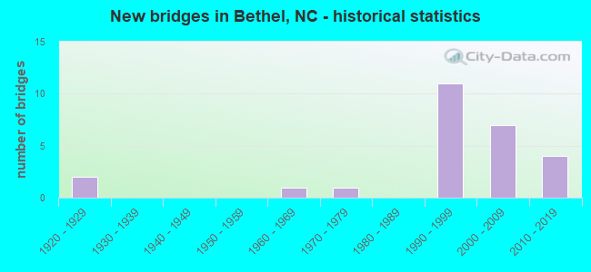
- New bridges - historical statistics
- 21920-1929
- 11960-1969
- 11970-1979
- 111990-1999
- 72000-2009
- 42010-2019
FCC Registered Cell Phone Towers:
1 (See the full list of FCC Registered Cell Phone Towers in Bethel)FCC Registered Antenna Towers:
77 (See the full list of FCC Registered Antenna Towers)FCC Registered Broadcast Land Mobile Towers:
5- James St (Lat: 35.808778 Lon: -77.374694), Call Sign: KJV248,
Assigned Frequencies: 154.355 MHz, Grant Date: 12/17/2010, Expiration Date: 03/06/2021, Cancellation Date: 05/08/2021, Registrant: Pitt County Emergency Management, 1717 West 5th Street, Greenville, NC 27834, Phone: (252) 902-3950, Fax: (252) 830-6348, Email:
- Lat: 35.768333 Lon: -77.364167, Call Sign: WPPU898,
Assigned Frequencies: 151.520 MHz, 159.585 MHz, 159.630 MHz, 159.900 MHz, 160.140 MHz, Grant Date: 01/25/2005, Expiration Date: 01/24/2015, Cancellation Date: 06/06/2015, Certifier: Larry Cuthberson, Registrant: Lao 20704413, 102 E. Middle St., Pineola, NC 28662, Phone: (828) 387-0861, Fax: (717) 337-9157, Email:
- FRY PAN MNT, Off Of Blue Ridge Pkwy (Lat: 35.393917 Lon: -82.774333), Type: Upole, Structure height: 16.8 m, Overall height: 18.3 m, Call Sign: WNZW464,
Assigned Frequencies: 452.650 MHz, Grant Date: 06/16/2022, Expiration Date: 07/07/2032, Registrant: Western Carolina Communications Systems Inc, Sylva, NC 28779-0488, Phone: (828) 586-0611, Fax: (828) 586-0451, Email:
- Lat: 35.768333 Lon: -77.364167, Call Sign: WQDN914,
Assigned Frequencies: 159.585 MHz, 159.630 MHz, 160.140 MHz, 151.520 MHz, 159.900 MHz, Grant Date: 08/29/2015, Expiration Date: 10/12/2025, Certifier: Larry Cuthbertson, Registrant: Mitch Grubb, 1715 Sells Road, Salisbury, NC 28144, Phone: (704) 798-2439, Email:
- HWY 11 METER VAULT, 77m Nne Of Intersection Of Sr 11 N & Sr 30 (Lat: 35.786389 Lon: -77.370833), Type: Pole, Structure height: 18.3 m, Call Sign: WQPC763,
Assigned Frequencies: 173.237 MHz, Grant Date: 04/09/2012, Expiration Date: 04/09/2022, Cancellation Date: 06/11/2022, Certifier: Todd Bullock, Registrant: Siemens Industry Inc, 1239 Willow Lake Blvd, Vadnais Heights, MN 55110, Phone: (651) 766-2700, Fax: (651) 766-2701, Email:
FCC Registered Microwave Towers:
2- FRYING PAN, Frying Pan Mtn (Lat: 35.393917 Lon: -82.774333), Type: Gtower, Structure height: 55.5 m, Call Sign: WPYN267,
Assigned Frequencies: 6093.45 MHz, Grant Date: 08/22/2023, Expiration Date: 09/12/2033, Certifier: Steven T Campbell, Registrant: Wilkinson Barker Knauer, LLP, 1800 M Street Nw, Suite 800n, Washington, DC 20036, Phone: (202) 383-3420, Fax: (202) 783-5851, Email:
- PISGAH CREEK, Frying Pan Mtn (Lat: 35.393917 Lon: -82.774333), Type: Ltower, Structure height: 55.5 m, Call Sign: WRJB557,
Assigned Frequencies: 11305.0 MHz, 11345.0 MHz, 11305.0 MHz, 11345.0 MHz, 11305.0 MHz, 11345.0 MHz, 11305.0 MHz, 11345.0 MHz, 11305.0 MHz, 11345.0 MHz, Grant Date: 07/31/2020, Expiration Date: 07/31/2030, Certifier: Christophe Le Scanve, Registrant: Cellco Partnership, 5055 North Point Pkwy, Np2ne Network Engineering, Alpharetta, GA 30022, Phone: (770) 797-1070, Email:
FCC Registered Amateur Radio Licenses:
4- Call Sign: KB4SV, Licensee ID: L00849229, Grant Date: 05/29/2014, Expiration Date: 07/09/2024, Certifier: Milton Jenkins Jr, Registrant: Milton Jenkins Jr, 412 Second St, Bethel, NC 27812
- Call Sign: WD4MAR, Grant Date: 06/21/1988, Expiration Date: 06/21/1998, Cancellation Date: 06/22/2000, Registrant: Marion S Davis Jr, 213 Pitt St, Bethel, NC 27812
- Call Sign: KE5ACR, Licensee ID: L00786883, Grant Date: 10/31/2013, Expiration Date: 01/26/2024, Cancellation Date: 05/13/2017, Certifier: Gary L Coriell, Registrant: Gary L Coriell, 1094 Us 64 Alt W, Bethel, NC 27812
- Call Sign: KK4GC, Previous Call Sign: KE5ACR, Licensee ID: L00786883, Grant Date: 05/13/2017, Expiration Date: 05/13/2027, Certifier: Gary L Coriell, Registrant: Gary L Coriell, 1094 Us 64 Alt W, Bethel, NC 27812
FAA Registered Aircraft:
2- Aircraft: BEECH A36 (Category: Land, Seats: 6, Weight: Up to 12,499 Pounds, Speed: 138 mph), Engine: CONT MOTOR IO 520 SERIES (285 HP) (Reciprocating)
N-Number: 200UG, N200UG, N-200UG, Serial Number: E-1225, Year manufactured: 1978, Airworthiness Date: 02/11/1978, Certificate Issue Date: 06/29/2019
Registrant (LLC): Raw Logistics LLC, Po Box 429, Bethel, NC 27812 - Aircraft: TIGER AIRCRAFT LLC AG-5B (Category: Land, Seats: 4, Weight: Up to 12,499 Pounds), Engine: LYCOMING O-360 SERIES (180 HP) (Reciprocating)
N-Number: 956TE, N956TE, N-956TE, Serial Number: 10235, Year manufactured: 2004, Airworthiness Date: 04/27/2004, Certificate Issue Date: 09/14/2016
Registrant (LLC): Raw Logistics LLC, Po Box 429, Bethel, NC 27812
| Home Mortgage Disclosure Act Aggregated Statistics For Year 2008 (Based on 1 partial tract) | ||
| C) Refinancings | ||
|---|---|---|
| Number | Average Value | |
| LOANS ORIGINATED | 0 | $0 |
| APPLICATIONS APPROVED, NOT ACCEPTED | 0 | $0 |
| APPLICATIONS DENIED | 1 | $51,060 |
| APPLICATIONS WITHDRAWN | 0 | $0 |
| FILES CLOSED FOR INCOMPLETENESS | 0 | $0 |
Detailed HMDA statistics for the following Tracts: 0020.02
2004 - 2018 National Fire Incident Reporting System (NFIRS) incidents
- Fire incident types reported to NFIRS in Bethel, NC
- 11639.9%Structure Fires
- 9833.7%Outside Fires
- 5819.9%Mobile Property/Vehicle Fires
- 196.5%Other
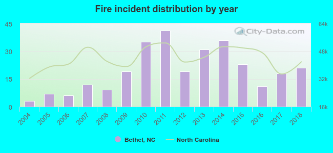 According to the data from the years 2004 - 2018 the average number of fire incidents per year is 19. The highest number of reported fires - 41 took place in 2011, and the least - 3 in 2004. The data has a rising trend.
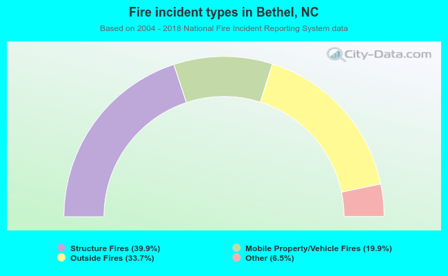 When looking into fire subcategories, the most reports belonged to: Structure Fires (39.9%), and Outside Fires (33.7%).
| Most common first names in Bethel, NC among deceased individuals | ||
| Name | Count | Lived (average) |
|---|---|---|
| William | 54 | 71.1 years |
| James | 53 | 72.0 years |
| John | 41 | 72.9 years |
| Mary | 26 | 74.6 years |
| Willie | 19 | 70.0 years |
| Robert | 19 | 69.5 years |
| Annie | 17 | 79.5 years |
| Rosa | 15 | 78.7 years |
| George | 13 | 70.0 years |
| Walter | 11 | 71.0 years |
| Most common last names in Bethel, NC among deceased individuals | ||
| Last name | Count | Lived (average) |
|---|---|---|
| Whitehurst | 42 | 74.1 years |
| Brown | 38 | 69.7 years |
| Staton | 32 | 71.9 years |
| Carson | 28 | 76.7 years |
| Williams | 26 | 63.3 years |
| Manning | 25 | 72.0 years |
| Council | 21 | 72.4 years |
| Purvis | 20 | 76.8 years |
| Andrews | 20 | 73.2 years |
| Jones | 20 | 72.1 years |
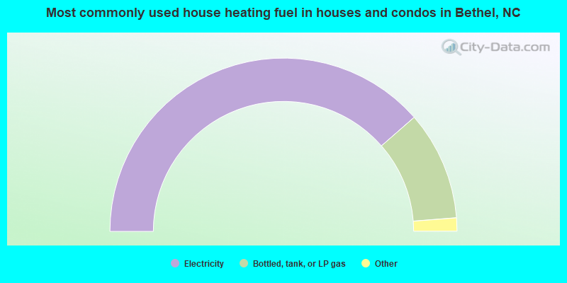
- 77.3%Electricity
- 20.4%Bottled, tank, or LP gas
- 1.2%Utility gas
- 1.0%Fuel oil, kerosene, etc.
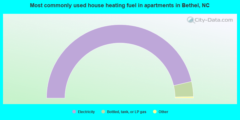
- 93.3%Electricity
- 6.7%Bottled, tank, or LP gas
Bethel compared to North Carolina state average:
- Median house value below state average.
- Unemployed percentage below state average.
- Black race population percentage above state average.
- Hispanic race population percentage significantly below state average.
- Foreign-born population percentage significantly below state average.
- Length of stay since moving in significantly above state average.
- House age significantly above state average.
- Number of college students below state average.

|
Total of 3 patent applications in 2008-2024.