Bethel, New York
Submit your own pictures of this town and show them to the world
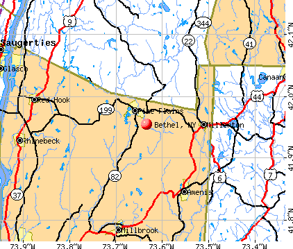
- OSM Map
- General Map
- Google Map
- MSN Map
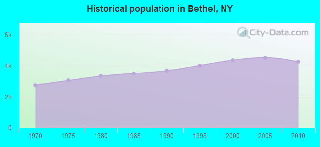
Population change since 2000: -2.5%
 |
| Males: 2,235 | |
| Females: 2,020 |
| Median resident age: | 46.3 years |
| New York median age: | 40.7 years |
Zip codes: 12786.
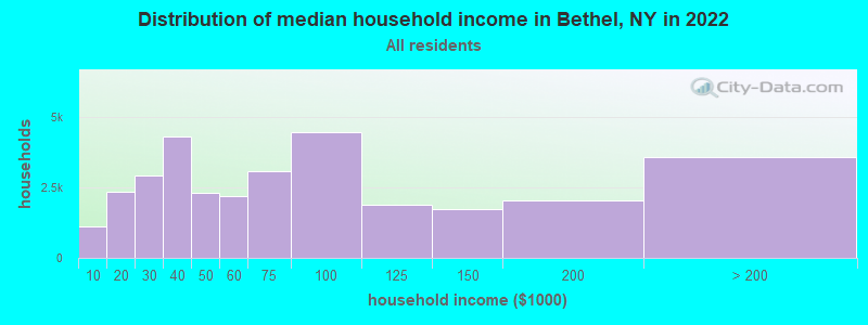
| Bethel: | $62,086 |
| NY: | $79,557 |
Estimated per capita income in 2022: $58,297 (it was $25,335 in 2000)
Bethel town income, earnings, and wages data
Estimated median house or condo value in 2022: $278,752 (it was $91,700 in 2000)
| Bethel: | $278,752 |
| NY: | $400,400 |
Mean prices in 2022: all housing units: $270,318; detached houses: $296,292; townhouses or other attached units: $279,664; in 2-unit structures: $506,859; in 3-to-4-unit structures: $161,643; in 5-or-more-unit structures: $372,499; mobile homes: $81,693
Detailed information about poverty and poor residents in Bethel, NY


- 3,50682.4%White alone
- 48511.4%Hispanic
- 1393.3%Black alone
- 681.6%Two or more races
- 360.8%Asian alone
- 130.3%American Indian alone
- 80.2%Other race alone
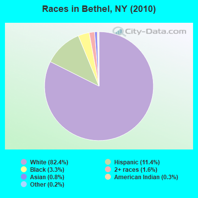
Races in Bethel detailed stats: ancestries, foreign born residents, place of birth
 Recent articles from our blog. Our writers, many of them Ph.D. graduates or candidates, create easy-to-read articles on a wide variety of topics.

 | For those interested in state political issues (425 replies) |
| $1.82 billion in development for Niagara Falls area in the works.... (336 replies) |
| Residents speak out about the proposed Kensington project (230 replies) |
| smaller Upstate NY cities and towns/African American communities (5974 replies) |
| Area events... (52 replies) |
| Mass shooting at Buffalo grocery (149 replies) |
Latest news from Bethel, NY collected exclusively by city-data.com from local newspapers, TV, and radio stations
Ancestries: Irish (19.2%), German (18.4%), Italian (12.9%), United States (7.1%), English (6.2%), Polish (5.1%).
Current Local Time: EST time zone
Land area: 85.4 square miles.
Population density: 50 people per square mile (very low).
370 residents are foreign born (4.3% Latin America, 3.9% Europe).
| This town: | 8.5% |
| New York: | 20.4% |
| Bethel town: | 2.3% ($2,154) |
| New York: | 1.9% ($2,847) |
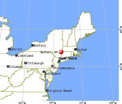
Nearest city with pop. 50,000+: Scranton, PA  (46.9 miles , pop. 76,415).
Nearest city with pop. 200,000+: Newark, NJ (74.4 miles , pop. 273,546).
Nearest city with pop. 1,000,000+: Bronx, NY (77.1 miles , pop. 1,332,650).
Nearest cities:
), ), ), ), ), ), )Latitude: 41.69 N, Longitude: 74.84 W
Area code commonly used in this area: 845

Bethel tourist attractions:
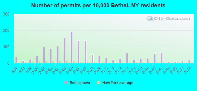
Single-family new house construction building permits:
- 2022: 8 buildings, average cost: $299,400
- 2021: 6 buildings, average cost: $326,300
- 2020: 5 buildings, average cost: $326,300
- 2019: 4 buildings, average cost: $326,300
- 2018: 27 buildings, average cost: $127,300
- 2017: 26 buildings, average cost: $127,300
- 2016: 13 buildings, average cost: $184,500
- 2015: 13 buildings, average cost: $120,400
- 2014: 8 buildings, average cost: $238,800
- 2013: 27 buildings, average cost: $147,700
- 2012: 12 buildings, average cost: $307,300
- 2011: 10 buildings, average cost: $214,300
- 2010: 14 buildings, average cost: $214,300
- 2009: 20 buildings, average cost: $227,100
- 2008: 23 buildings, average cost: $333,600
- 2007: 60 buildings, average cost: $272,200
- 2006: 60 buildings, average cost: $342,300
- 2005: 84 buildings, average cost: $166,500
- 2004: 69 buildings, average cost: $312,200
- 2003: 45 buildings, average cost: $149,200
- 2002: 38 buildings, average cost: $172,900
- 2001: 43 buildings, average cost: $114,600
- 2000: 20 buildings, average cost: $164,200
- 1999: 11 buildings, average cost: $109,700
- 1998: 7 buildings, average cost: $89,600
- 1997: 16 buildings, average cost: $146,100

| Here: | 3.9% |
| New York: | 4.4% |
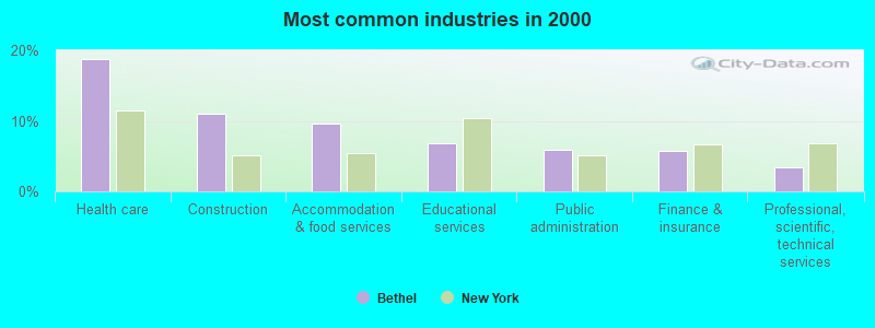
- Health care (18.8%)
- Construction (11.0%)
- Accommodation & food services (9.6%)
- Educational services (6.8%)
- Public administration (5.9%)
- Finance & insurance (5.7%)
- Professional, scientific, technical services (3.5%)
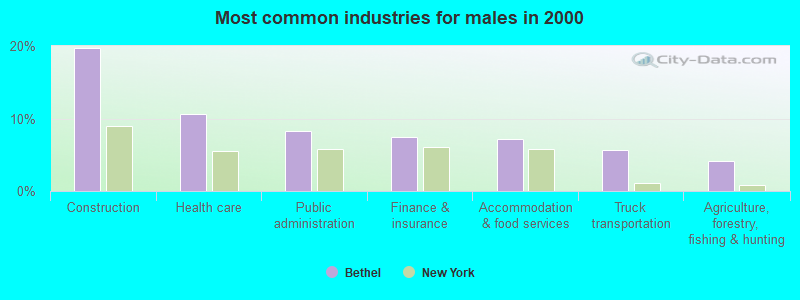
- Construction (19.8%)
- Health care (10.7%)
- Public administration (8.3%)
- Finance & insurance (7.5%)
- Accommodation & food services (7.2%)
- Truck transportation (5.7%)
- Agriculture, forestry, fishing & hunting (4.1%)
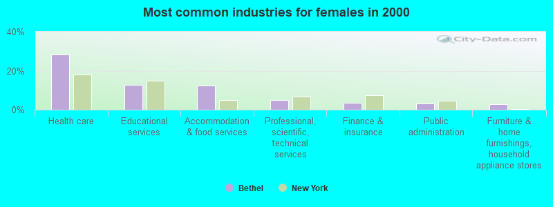
- Health care (28.1%)
- Educational services (12.6%)
- Accommodation & food services (12.5%)
- Professional, scientific, technical services (4.9%)
- Finance & insurance (3.6%)
- Public administration (3.1%)
- Furniture & home furnishings, household appliance stores (2.9%)
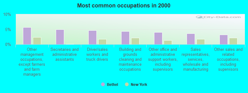
- Other management occupations, except farmers and farm managers (5.6%)
- Secretaries and administrative assistants (4.9%)
- Driver/sales workers and truck drivers (4.6%)
- Building and grounds cleaning and maintenance occupations (4.4%)
- Other office and administrative support workers, including supervisors (4.0%)
- Sales representatives, services, wholesale and manufacturing (3.6%)
- Other sales and related occupations, including supervisors (3.2%)
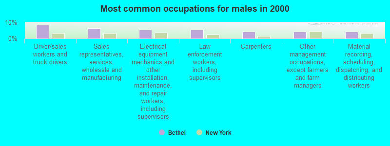
- Driver/sales workers and truck drivers (8.6%)
- Sales representatives, services, wholesale and manufacturing (6.4%)
- Electrical equipment mechanics and other installation, maintenance, and repair workers, including supervisors (5.6%)
- Law enforcement workers, including supervisors (5.3%)
- Carpenters (4.2%)
- Other management occupations, except farmers and farm managers (4.1%)
- Material recording, scheduling, dispatching, and distributing workers (4.1%)
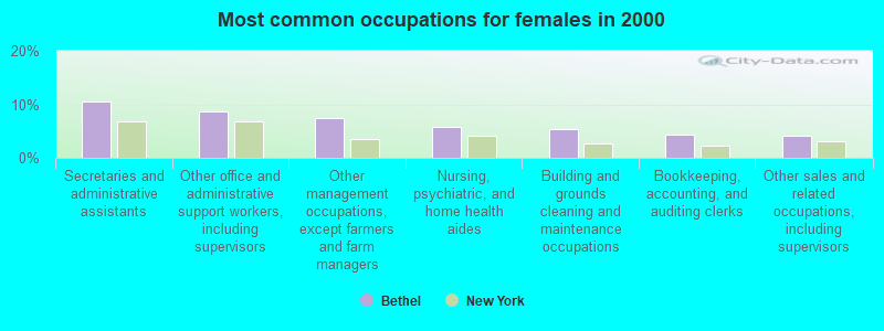
- Secretaries and administrative assistants (10.5%)
- Other office and administrative support workers, including supervisors (8.6%)
- Other management occupations, except farmers and farm managers (7.4%)
- Nursing, psychiatric, and home health aides (5.8%)
- Building and grounds cleaning and maintenance occupations (5.4%)
- Bookkeeping, accounting, and auditing clerks (4.3%)
- Other sales and related occupations, including supervisors (4.2%)
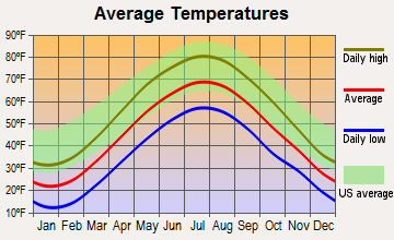
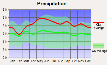
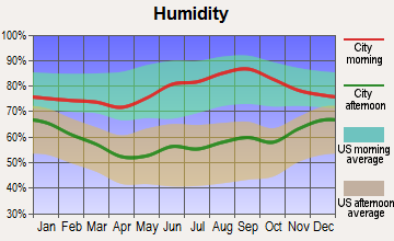
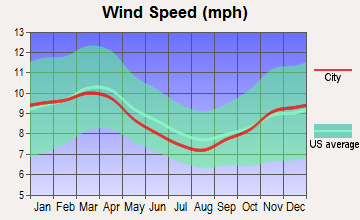
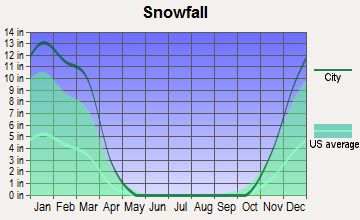
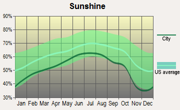
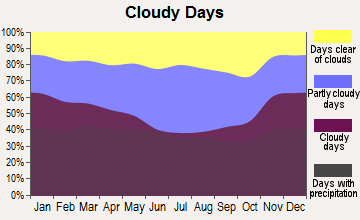
Average climate in Bethel, New York
Based on data reported by over 4,000 weather stations
Tornado activity:
Bethel-area historical tornado activity is slightly above New York state average. It is 46% smaller than the overall U.S. average.
On 5/31/1998, a category F3 (max. wind speeds 158-206 mph) tornado 28.1 miles away from the Bethel town center injured 12 people and caused $3 million in damages.
On 7/14/1988, a category F3 tornado 29.7 miles away from the town center injured one person and caused between $500,000 and $5,000,000 in damages.
Earthquake activity:
Bethel-area historical earthquake activity is significantly above New York state average. It is 67% smaller than the overall U.S. average.On 10/7/1983 at 10:18:46, a magnitude 5.3 (5.1 MB, 5.3 LG, 5.1 ML, Class: Moderate, Intensity: VI - VII) earthquake occurred 158.5 miles away from Bethel center
On 4/20/2002 at 10:50:47, a magnitude 5.3 (5.3 ML, Depth: 3.0 mi) earthquake occurred 203.5 miles away from the city center
On 8/23/2011 at 17:51:04, a magnitude 5.8 (5.8 MW, Depth: 3.7 mi) earthquake occurred 308.9 miles away from the city center
On 4/20/2002 at 10:50:47, a magnitude 5.2 (5.2 MB, 4.2 MS, 5.2 MW, 5.0 MW) earthquake occurred 201.6 miles away from the city center
On 1/16/1994 at 01:49:16, a magnitude 4.6 (4.6 MB, 4.6 LG, Depth: 3.1 mi, Class: Light, Intensity: IV - V) earthquake occurred 112.9 miles away from Bethel center
On 6/17/1991 at 08:53:16, a magnitude 4.1 (4.0 MB, 4.0 LG, Depth: 3.1 mi) earthquake occurred 65.5 miles away from Bethel center
Magnitude types: regional Lg-wave magnitude (LG), body-wave magnitude (MB), local magnitude (ML), surface-wave magnitude (MS), moment magnitude (MW)
Natural disasters:
The number of natural disasters in Sullivan County (29) is a lot greater than the US average (15).Major Disasters (Presidential) Declared: 19
Emergencies Declared: 9
Causes of natural disasters: Floods: 11, Storms: 11, Hurricanes: 5, Snowstorms: 3, Blizzards: 2, Heavy Rain: 1, Power Outage: 1, Tornado: 1, Tropical Depression: 1, Tropical Storm: 1, Water Shortage: 1, Winter Storm: 1, Other: 3 (Note: some incidents may be assigned to more than one category).
Hospitals and medical centers near Bethel:
- CATSKILL DIALYSIS CENTER (Dialysis Facility, about 8 miles away; MONTICELLO, NY)
- HOSPICE OF SULLIVAN COUNTY INC (Hospital, about 9 miles away; MONTICELLO, NY)
- ACHIEVE REHAB AND NURSING FACILITY (Nursing Home, about 9 miles away; LIBERTY, NY)
- SDTC - THE CENTER FOR DISCOVERY (Hospital, about 10 miles away; LIBERTY, NY)
- SULLIVAN COUNTY ADULT CARE CENTER (Nursing Home, about 11 miles away; LIBERTY, NY)
Colleges/universities with over 2000 students nearest to Bethel:
- Orange County Community College (about 28 miles; Middletown, NY; Full-time enrollment: 4,742)
- Ulster County Community College (about 39 miles; Stone Ridge, NY; FT enrollment: 2,207)
- State University of New York at New Paltz (about 40 miles; New Paltz, NY; FT enrollment: 7,319)
- SUNY College of Technology at Delhi (about 41 miles; Delhi, NY; FT enrollment: 2,911)
- Sussex County Community College (about 44 miles; Newton, NJ; FT enrollment: 2,402)
- Mount Saint Mary College (about 45 miles; Newburgh, NY; FT enrollment: 2,166)
- Marywood University (about 45 miles; Scranton, PA; FT enrollment: 2,959)
Points of interest:
Notable locations in Bethel: Bethel Town Landfill (A), Island Glen Country Club (B), Beaverdam Brook Farms (C), Pelleh Farms (D), Tenmile River Camps (E), Kauneonga Lake Sewage Treatment Plant (F), Swan Lake Golf and Country Club (G), Kauneonga Lake Fire Department (H), White Lake Fire Company (I), Smallwood - Mongaup Valley Fire Company (J). Display/hide their locations on the map
Churches in Bethel include: Saint Anns Church (A), Saint Marys Church (B), White Lake Church (C), Mongaup Valley Church (D), Reformed Church (E). Display/hide their locations on the map
Cemeteries: Soule Cemetery (1), Bethel Evergreen Cemetery (2), Stewart Cemetery (3), Fayerweather Cemetery (4), Fulton Cemetery (5), Lyon Cemetery (6), Van Keuren Cemetery (7). Display/hide their locations on the map
Lakes, reservoirs, and swamps: Indian Field Pond (A), Kilcoin Pond (B), Little Black Lake (C), Lynchs Pond (D), Mallory Pond (E), Meyers Pond (F), Lake Nianque (G), Sicans Pond (H). Display/hide their locations on the map
Streams, rivers, and creeks: Frasers Brook (A), White Lake Brook (B), Hemp Meadow Brook (C), Creamery Brook (D), West Branch Mongaup River (E), Beaverdam Brook (F), Mallory Brook (G), Lybolt Brook (H), Lemons Brook (I). Display/hide their locations on the map
Drinking water stations with addresses in Bethel and their reported violations in the past:
HECTORS INN (Population served: 50, Groundwater):Past monitoring violations:
- 4 routine major monitoring violations
| This town: | 2.4 people |
| New York: | 2.6 people |
| This town: | 63.4% |
| Whole state: | 63.5% |
| This town: | 9.3% |
| Whole state: | 6.8% |
Likely homosexual households (counted as self-reported same-sex unmarried-partner households)
- Lesbian couples: 0.8% of all households
- Gay men: 0.7% of all households
| This town: | 14.9% |
| Whole state: | 14.6% |
| This town: | 4.6% |
| Whole state: | 7.4% |
70 people in group homes intended for adults in 2010
People in group quarters in Bethel in 2000:
- 199 people in hospitals or wards for drug/alcohol abuse
- 103 people in agriculture workers' dormitories on farms
- 18 people in homes for the mentally retarded
- 10 people in other noninstitutional group quarters
For population 15 years and over in Bethel:
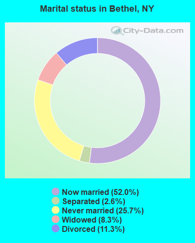
- Never married: 25.7%
- Now married: 52.0%
- Separated: 2.6%
- Widowed: 8.3%
- Divorced: 11.3%
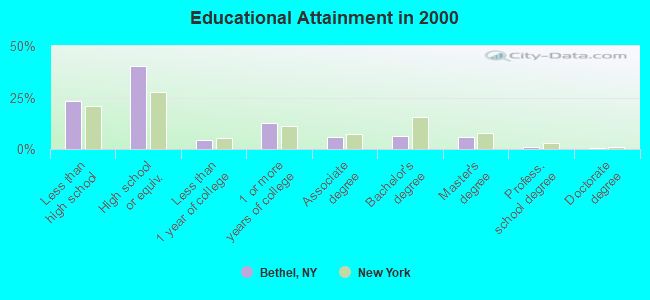
For population 25 years and over in Bethel:
- High school or higher: 76.9%
- Bachelor's degree or higher: 13.9%
- Graduate or professional degree: 7.3%
- Unemployed: 15.7%
- Mean travel time to work (commute): 32.3 minutes
| Here: | 11.7 |
| New York average: | 14.2 |
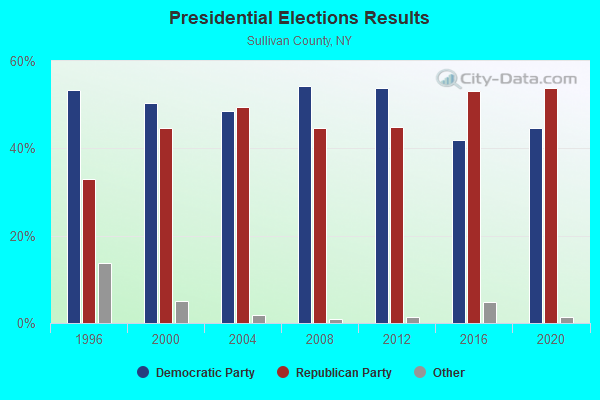
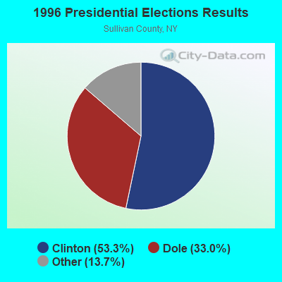
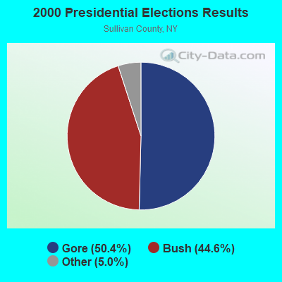
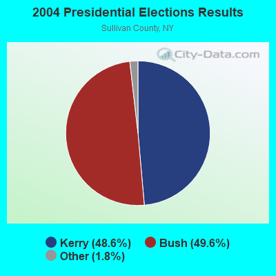

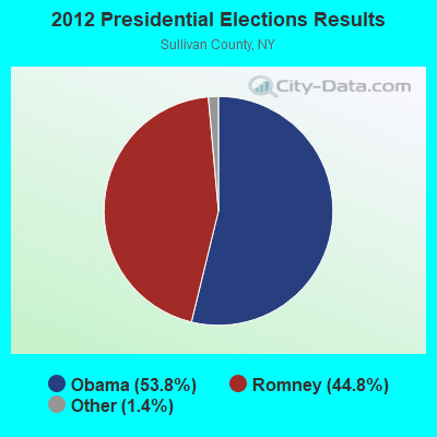
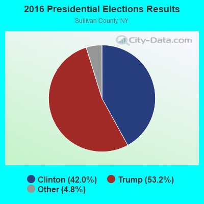
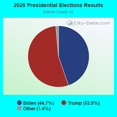
Graphs represent county-level data. Detailed 2008 Election Results
Religion statistics for Bethel, NY (based on Sullivan County data)
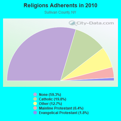
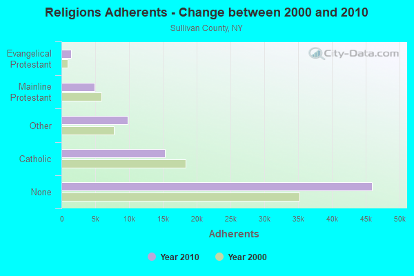
| Religion | Adherents | Congregations |
|---|---|---|
| Catholic | 15,352 | 21 |
| Other | 9,817 | 31 |
| Mainline Protestant | 4,947 | 44 |
| Evangelical Protestant | 1,399 | 18 |
| Orthodox | 60 | 2 |
| None | 45,972 | - |
Food Environment Statistics:
| Sullivan County: | 4.06 / 10,000 pop. |
| New York: | 4.13 / 10,000 pop. |
| Sullivan County: | 0.13 / 10,000 pop. |
| State: | 0.06 / 10,000 pop. |
| This county: | 2.22 / 10,000 pop. |
| New York: | 0.92 / 10,000 pop. |
| This county: | 5.63 / 10,000 pop. |
| New York: | 1.68 / 10,000 pop. |
| This county: | 10.99 / 10,000 pop. |
| State: | 8.82 / 10,000 pop. |
| This county: | 9.4% |
| New York: | 8.2% |
| Sullivan County: | 24.1% |
| New York: | 23.8% |
| This county: | 16.4% |
| New York: | 15.6% |
Businesses in Bethel, NY
- U-Haul: 1
Strongest AM radio stations in Bethel:
- WMCA (570 AM; 50 kW; NEW YORK, NY; Owner: SALEM MEDIA OF NEW YORK, LLC)
- WABC (770 AM; 50 kW; NEW YORK, NY; Owner: WABC-AM RADIO, INC.)
- WOR (710 AM; 50 kW; NEW YORK, NY; Owner: BUCKLEY BROADCASTING CORPORATION)
- WFAN (660 AM; 50 kW; NEW YORK, NY; Owner: INFINITY BROADCASTING OPERATIONS, INC.)
- WVOS (1240 AM; 1 kW; LIBERTY, NY; Owner: MOUNTAIN BROADCASTING CORPORATION)
- WINS (1010 AM; 50 kW; NEW YORK, NY; Owner: INFINITY BROADCASTING OPERATIONS, INC.)
- WSNR (620 AM; 20 kW; JERSEY CITY, NJ)
- WEPN (1050 AM; 50 kW; NEW YORK, NY; Owner: NEW YORK AM RADIO, LLC)
- WCBS (880 AM; 50 kW; NEW YORK, NY; Owner: INFINITY BROADCASTING OPERATIONS, INC.)
- WWJZ (640 AM; 50 kW; MOUNT HOLLY, NJ; Owner: ABC, INC.)
- WBBR (1130 AM; 50 kW; NEW YORK, NY; Owner: BLOOMBERG COMMUNICATIONS INC.)
- WGY (810 AM; 50 kW; SCHENECTADY, NY; Owner: CLEAR CHANNEL BROADCASTING LICENSES, INC.)
- WADO (1280 AM; 50 kW; NEW YORK, NY; Owner: WADO-AM LICENSE CORP.)
Strongest FM radio stations in Bethel:
- WDNB (102.1 FM; JEFFERSONVILLE, NY; Owner: DE WIT BROADCASTING CORP.)
- WJFF (90.5 FM; JEFFERSONVILLE, NY; Owner: RADIO CATSKILL)
- WSUL (98.3 FM; MONTICELLO, NY; Owner: REYNOLDS COMMUNICATIONS, INC.)
- WPDA (106.1 FM; JEFFERSONVILLE, NY; Owner: CUMULUS LICENSING CORP.)
- WJUX (99.7 FM; MONTICELLO, NY; Owner: MONTICELLO MOUNTAIN TOP BROADCASTING, INC.)
- WGWR (88.1 FM; LIBERTY, NY; Owner: SOUND OF LIFE, INC.)
- WFKP (99.3 FM; ELLENVILLE, NY; Owner: CLEAR CHANNEL BROADCASTING LICENSES, INC.)
- WVOS-FM (95.9 FM; LIBERTY, NY; Owner: MOUNTAIN BROADCASTING CORPORATION)
- WOSR (91.7 FM; MIDDLETOWN, NY; Owner: WAMC)
- W233AH (94.5 FM; MONTICELLO, NY; Owner: RADIO CATSKILL)
- WZAD (97.3 FM; WURTSBORO, NY; Owner: CUMULUS LICENSING CORP.)
- WPDH (101.5 FM; POUGHKEEPSIE, NY; Owner: CUMULUS LICENSING CORP.)
- WPGP (88.3 FM; TAFTON, PA; Owner: SOUND OF LIFE, INC.)
- WXHD (90.1 FM; MOUNT HOPE, NY; Owner: AURICLE COMMUNICATIONS)
- WQFN (100.1 FM; FOREST CITY, PA; Owner: THE SCRANTON TIMES, L.P.)
- WTSX (96.7 FM; PORT JERVIS, NY; Owner: PORT JERVIS BROADCASTING CO., INC.)
- WYCY (105.3 FM; HAWLEY, PA; Owner: DE WIT BROADCASTING CORPORATION)
- WRPJ (88.9 FM; PORT JERVIS, NY; Owner: SOUND OF LIFE, INC.)
- WAMK (90.9 FM; KINGSTON, NY; Owner: W A M C)
- WDNH-FM (95.3 FM; HONESDALE, PA; Owner: DE WIT BROADCASTING CORPORATION)
TV broadcast stations around Bethel:
- W51BN (Channel 51; WHITE LAKE, NY; Owner: JOHN MESTER INCOME FAMILY TRUST)
- W30AZ (Channel 30; LIBERTY, NY; Owner: JOHN MESTER INCOME FAMILY TRUST)
- W27AL (Channel 27; MONTICELLO, NY; Owner: JOHN MESTER INCOME FAMILY TRUST)
Medal of Honor Recipients
Medal of Honor Recipient born in Bethel: John Simmons.
- National Bridge Inventory (NBI) Statistics
- 9Number of bridges
- 30ft / 9.3mTotal length
- $4,430,000Total costs
- 6,177Total average daily traffic
- 596Total average daily truck traffic
- 7,196Total future (year 2036) average daily traffic
FCC Registered Antenna Towers: 16 (See the full list of FCC Registered Antenna Towers)
FCC Registered Broadcast Land Mobile Towers: 10 (See the full list of FCC Registered Broadcast Land Mobile Towers in Bethel, NY)
FCC Registered Microwave Towers: 9 (See the full list of FCC Registered Microwave Towers in this town)
| Most common first names in Bethel, NY among deceased individuals | ||
| Name | Count | Lived (average) |
|---|---|---|
| Charles | 3 | 79.0 years |
| George | 2 | 61.5 years |
| Agnes | 2 | 71.5 years |
| Edward | 2 | 66.5 years |
| Frank | 2 | 73.5 years |
| Anna | 2 | 88.9 years |
| Florence | 2 | 86.5 years |
| John | 2 | 65.0 years |
| Joseph | 2 | 73.0 years |
| Marjorie | 2 | 81.5 years |
| Most common last names in Bethel, NY among deceased individuals | ||
| Last name | Count | Lived (average) |
|---|---|---|
| Brown | 5 | 85.4 years |
| Brucher | 3 | 82.7 years |
| Coots | 2 | 82.0 years |
| Grossman | 2 | 79.5 years |
| Altman | 2 | 70.0 years |
| Engel | 2 | 72.0 years |
| Feinburg | 2 | 78.5 years |
| Bastone | 2 | 85.0 years |
| Boll | 2 | 97.0 years |
| Isseroff | 2 | 80.0 years |
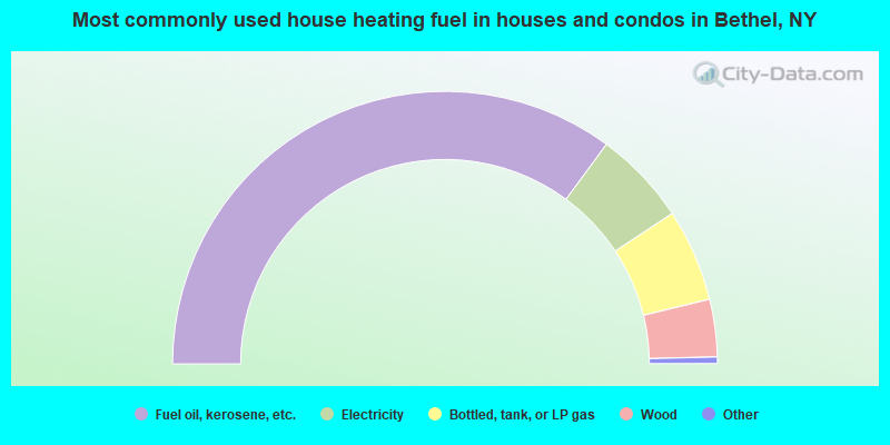
- 70.2%Fuel oil, kerosene, etc.
- 11.2%Electricity
- 11.0%Bottled, tank, or LP gas
- 6.8%Wood
- 0.4%Utility gas
- 0.4%Coal or coke
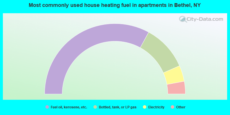
- 65.9%Fuel oil, kerosene, etc.
- 21.0%Bottled, tank, or LP gas
- 7.3%Electricity
- 2.4%Wood
- 2.1%Other fuel
- 1.2%Utility gas
Bethel compared to New York state average:
- Black race population percentage significantly below state average.
- Hispanic race population percentage below state average.
- Median age above state average.
- Foreign-born population percentage significantly below state average.
- Renting percentage below state average.
- Length of stay since moving in significantly above state average.
- Number of rooms per house significantly below state average.
- House age significantly below state average.
- Institutionalized population percentage above state average.
- Number of college students below state average.
- Percentage of population with a bachelor's degree or higher below state average.
Bethel on our top lists:
- #2 on the list of "Top 101 cities with the largest percentage of people in hospitals or wards for drug/alcohol abuse (population 1,000+)"
- #36 on the list of "Top 101 cities with the largest percentage of people in agriculture workers' dormitories on farms (population 1,000+)"
- #50 on the list of "Top 101 cities with the most residents born in Other Central America (population 500+)"
- #43 on the list of "Top 101 counties with the highest surface withdrawal of fresh water for public supply"
- #47 on the list of "Top 101 counties with the smallest number of children under 18 without health insurance coverage in 2000 (pop. 50,000+)"
- #61 on the list of "Top 101 counties with the highest total withdrawal of fresh water for public supply"
- #72 on the list of "Top 101 counties with the largest number of people moving out compared to moving in (pop. 50,000+)"
- #101 on the list of "Top 101 counties with the smallest number of people without health insurance coverage in 2000 (pop. 50,000+)"