Bellmont, New York
Submit your own pictures of this town and show them to the world
- OSM Map
- Google Map
- MSN Map
Population change since 2000: +0.8%
 |
| Males: 749 | |
| Females: 685 |
| Median resident age: | 46.1 years |
| New York median age: | 40.7 years |
Zip codes: 12969.
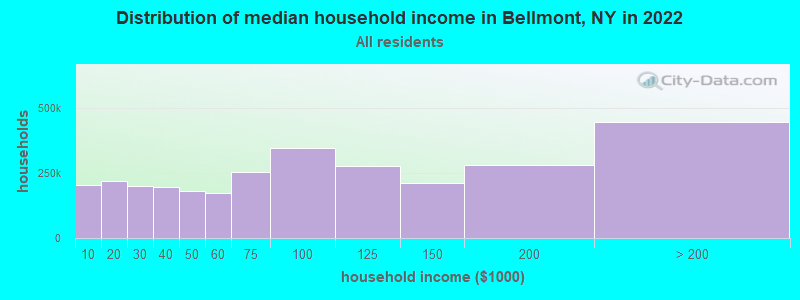
| Bellmont: | $62,467 |
| NY: | $79,557 |
Estimated per capita income in 2022: $31,829 (it was $16,542 in 2000)
Bellmont town income, earnings, and wages data
Estimated median house or condo value in 2022: $135,571 (it was $58,800 in 2000)
| Bellmont: | $135,571 |
| NY: | $400,400 |
Mean prices in 2022: all housing units: $219,333; detached houses: $244,011; townhouses or other attached units: $364,147; in 2-unit structures: $197,583; in 3-to-4-unit structures: $157,263; in 5-or-more-unit structures: $800,159; mobile homes: $60,247
Detailed information about poverty and poor residents in Bellmont, NY


- 1,39297.1%White alone
- 141.0%Hispanic
- 100.7%Two or more races
- 90.6%American Indian alone
- 50.3%Black alone
- 40.3%Asian alone

Races in Bellmont detailed stats: ancestries, foreign born residents, place of birth
 Recent articles from our blog. Our writers, many of them Ph.D. graduates or candidates, create easy-to-read articles on a wide variety of topics.
Ancestries: French (55.0%), Irish (20.7%), English (19.1%), German (5.8%), Scottish (4.8%), Italian (4.1%).
Current Local Time: EST time zone
Incorporated on 03/16/1833
Land area: 164.4 square miles.
Population density: 8.7 people per square mile (very low).
41 residents are foreign born (2.2% North America, 0.6% Europe).
| This town: | 2.9% |
| New York: | 20.4% |
| Bellmont town: | 2.2% ($1,313) |
| New York: | 1.9% ($2,847) |
Nearest city with pop. 50,000+: Utica, NY  (127.1 miles , pop. 60,651).
Nearest city with pop. 200,000+: Rochester, NY (205.9 miles , pop. 219,773).
Nearest city with pop. 1,000,000+: Bronx, NY (269.9 miles , pop. 1,332,650).
Nearest cities:
), ), ), ), Latitude: 44.75 N, Longitude: 74.11 W
Area code commonly used in this area: 518
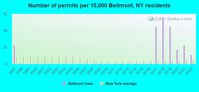
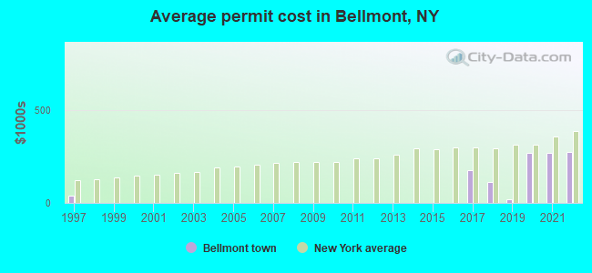
Single-family new house construction building permits:
- 2022: 2 buildings, average cost: $272,900
- 2021: 4 buildings, average cost: $266,700
- 2020: 3 buildings, average cost: $266,700
- 2019: 8 buildings, average cost: $18,800
- 2018: 10 buildings, average cost: $110,000
- 2017: 8 buildings, average cost: $177,100
- 1997: 4 buildings, average cost: $36,500
| Here: | 4.6% |
| New York: | 4.4% |
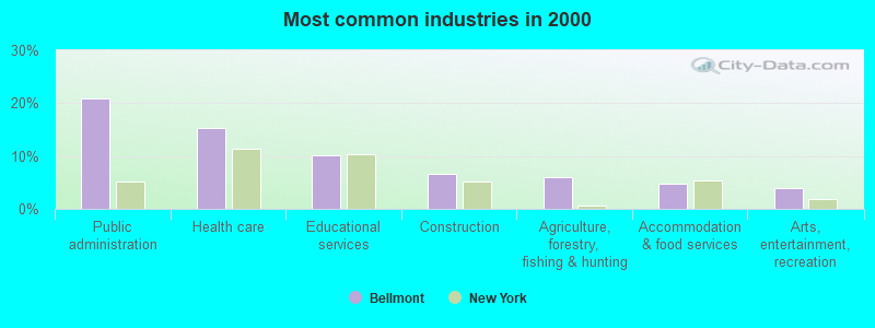
- Public administration (20.8%)
- Health care (15.3%)
- Educational services (10.2%)
- Construction (6.6%)
- Agriculture, forestry, fishing & hunting (6.1%)
- Accommodation & food services (4.9%)
- Arts, entertainment, recreation (3.9%)
- Public administration (27.0%)
- Construction (13.7%)
- Agriculture, forestry, fishing & hunting (11.1%)
- Educational services (6.8%)
- Metal & metal products (3.6%)
- Truck transportation (3.6%)
- Utilities (3.3%)
- Health care (28.3%)
- Public administration (15.1%)
- Educational services (13.3%)
- Accommodation & food services (6.6%)
- Arts, entertainment, recreation (4.5%)
- Religious, grantmaking, civic, professional, similar organizations (3.6%)
- Leather & allied products (3.0%)
- Law enforcement workers, including supervisors (8.9%)
- Preschool, kindergarten, elementary, and middle school teachers (4.9%)
- Other management occupations, except farmers and farm managers (4.4%)
- Nursing, psychiatric, and home health aides (4.4%)
- Other office and administrative support workers, including supervisors (4.2%)
- Driver/sales workers and truck drivers (4.1%)
- Farmers and farm managers (3.4%)
- Law enforcement workers, including supervisors (16.0%)
- Driver/sales workers and truck drivers (8.5%)
- Farmers and farm managers (6.5%)
- Electrical equipment mechanics and other installation, maintenance, and repair workers, including supervisors (5.9%)
- Other management occupations, except farmers and farm managers (4.2%)
- Material recording, scheduling, dispatching, and distributing workers (3.3%)
- Construction laborers (2.9%)
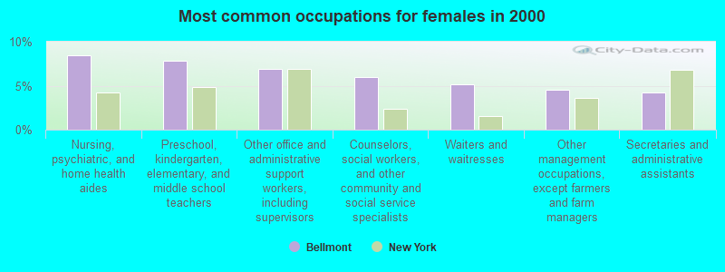
- Nursing, psychiatric, and home health aides (8.4%)
- Preschool, kindergarten, elementary, and middle school teachers (7.8%)
- Other office and administrative support workers, including supervisors (6.9%)
- Counselors, social workers, and other community and social service specialists (6.0%)
- Waiters and waitresses (5.1%)
- Other management occupations, except farmers and farm managers (4.5%)
- Secretaries and administrative assistants (4.2%)
Average climate in Bellmont, New York
Based on data reported by over 4,000 weather stations


(lower is better)
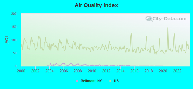
Air Quality Index (AQI) level in 2019 was 0.688. This is significantly better than average.
| City: | 0.688 |
| U.S.: | 72.561 |
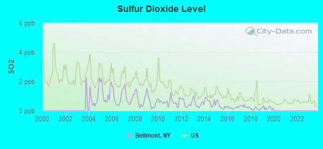
Sulfur Dioxide (SO2) [ppb] level in 2019 was 0.184. This is significantly better than average. Closest monitor was 22.6 miles away from the city center.
| City: | 0.184 |
| U.S.: | 1.515 |
Earthquake activity:
Bellmont-area historical earthquake activity is above New York state average. It is 76% smaller than the overall U.S. average.On 4/20/2002 at 10:50:47, a magnitude 5.3 (5.3 ML, Depth: 3.0 mi, Class: Moderate, Intensity: VI - VII) earthquake occurred 25.8 miles away from Bellmont center
On 4/20/2002 at 10:50:47, a magnitude 5.2 (5.2 MB, 4.2 MS, 5.2 MW, 5.0 MW) earthquake occurred 26.2 miles away from the city center
On 10/7/1983 at 10:18:46, a magnitude 5.3 (5.1 MB, 5.3 LG, 5.1 ML) earthquake occurred 56.0 miles away from Bellmont center
On 1/19/1982 at 00:14:42, a magnitude 4.7 (4.5 MB, 4.7 MD, 4.5 LG, Class: Light, Intensity: IV - V) earthquake occurred 151.4 miles away from the city center
On 10/16/2012 at 23:12:25, a magnitude 4.7 (4.7 ML, Depth: 10.0 mi) earthquake occurred 188.7 miles away from the city center
On 4/8/2003 at 15:06:14, a magnitude 3.7 (3.7 MB, Depth: 6.2 mi, Class: Light, Intensity: II - III) earthquake occurred 14.6 miles away from the city center
Magnitude types: regional Lg-wave magnitude (LG), body-wave magnitude (MB), duration magnitude (MD), local magnitude (ML), surface-wave magnitude (MS), moment magnitude (MW)
Natural disasters:
The number of natural disasters in Franklin County (15) is near the US average (15).Major Disasters (Presidential) Declared: 9
Emergencies Declared: 5
Causes of natural disasters: Floods: 5, Storms: 5, Hurricanes: 3, Winter Storms: 2, Blizzard: 1, Earthquake: 1, Power Outage: 1, Snowstorm: 1, Tornado: 1, Wind: 1, Other: 2 (Note: some incidents may be assigned to more than one category).
Hospitals and medical centers near Bellmont:
- FRANKLIN COUNTY PUBLIC HEALTH SERVICES CHHA (Home Health Center, about 12 miles away; MALONE, NY)
- FRANKLIN COUNTY NURSING HOME (Nursing Home, about 12 miles away; MALONE, NY)
- ALICE HYDE MEDICAL CENTER Acute Care Hospitals (about 12 miles away; MALONE, NY)
- CITIZEN ADVOCATES D/B/A NORTHSTAR INDUSTRIES, INC (Hospital, about 13 miles away; MALONE, NY)
- CITIZEN ADVOCATES D/B/A NORTH STAR INDUSTRIES, INC (Hospital, about 13 miles away; CHATEAUGAY, NY)
Colleges/universities with over 2000 students nearest to Bellmont:
- SUNY College at Plattsburgh (about 32 miles; Plattsburgh, NY; Full-time enrollment: 5,934)
- SUNY College at Potsdam (about 44 miles; Potsdam, NY; FT enrollment: 4,307)
- Clarkson University (about 45 miles; Potsdam, NY; FT enrollment: 3,472)
- Champlain College (about 49 miles; Burlington, VT; FT enrollment: 2,623)
- University of Vermont (about 49 miles; Burlington, VT; FT enrollment: 11,566)
- Community College of Vermont (about 49 miles; Winooski, VT; FT enrollment: 3,394)
- Saint Michael's College (about 50 miles; Colchester, VT; FT enrollment: 2,336)
Points of interest:
Notable locations in Bellmont: Middle Kilns (A), Upper Kilns (B), Brainardsville Sewer District 1 Wastewater Treatment Plant (C), Blairs Kiln (D). Display/hide their locations on the map
Churches in Bellmont include: Saint Josephs Church (A), White Church (B). Display/hide their locations on the map
Cemeteries: Brainardsville Cemetery (1), Bunker Hill Cemetery (2), Bellmont Center Cemetery (3), Morningside Cemetery (4), Merrill Cemetery (5). Display/hide their locations on the map
Lakes and reservoirs: Indian Lake (A), Ingraham Pond (B), Lily Pod Pond (C), Lilypad Pond (D), Lost Pond (E), Mountain Pond (F), Mountain View Lake (G), Mud Pond (H). Display/hide their locations on the map
Streams, rivers, and creeks: Foster Brook (A), Plumadore Outlet (B), Fender Brook (C), East Branch Trout River (D), Barnes Brook (E), Ragged Lake Outlet (F), Chateaugay River (G), Rocky Brook (H), West Branch Trout River (I). Display/hide their locations on the map
| This town: | 2.3 people |
| New York: | 2.6 people |
| This town: | 65.6% |
| Whole state: | 63.5% |
| This town: | 9.1% |
| Whole state: | 6.8% |
Likely homosexual households (counted as self-reported same-sex unmarried-partner households)
- Lesbian couples: 0.2% of all households
- Gay men: 0.0% of all households
| This town: | 9.8% |
| Whole state: | 14.6% |
| This town: | 3.3% |
| Whole state: | 7.4% |
For population 15 years and over in Bellmont:
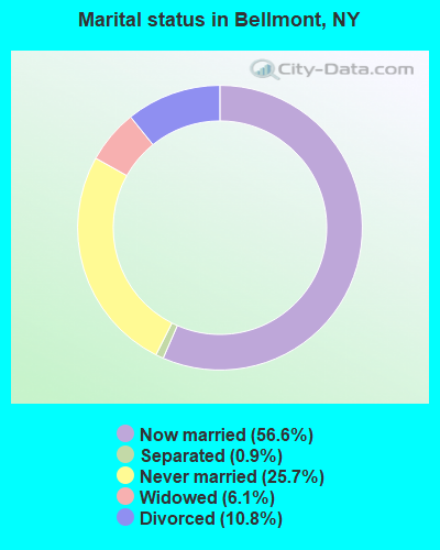
- Never married: 25.7%
- Now married: 56.6%
- Separated: 0.9%
- Widowed: 6.1%
- Divorced: 10.8%
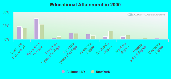
For population 25 years and over in Bellmont:
- High school or higher: 76.3%
- Bachelor's degree or higher: 13.4%
- Graduate or professional degree: 8.2%
- Unemployed: 8.6%
- Mean travel time to work (commute): 22.8 minutes
| Here: | 12.6 |
| New York average: | 14.2 |
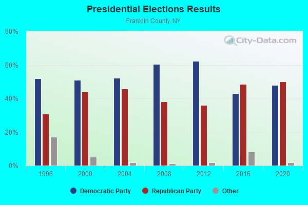
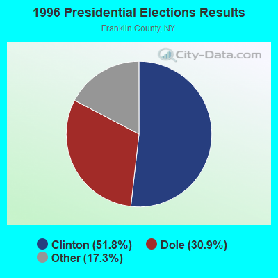
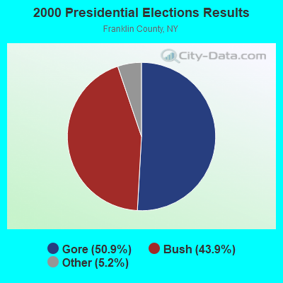
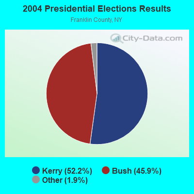
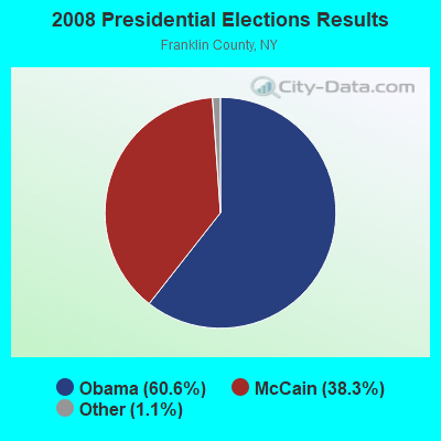
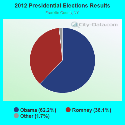
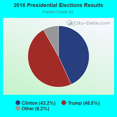

Graphs represent county-level data. Detailed 2008 Election Results
Religion statistics for Bellmont, NY (based on Franklin County data)
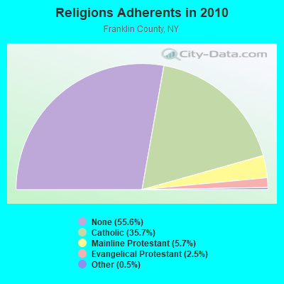
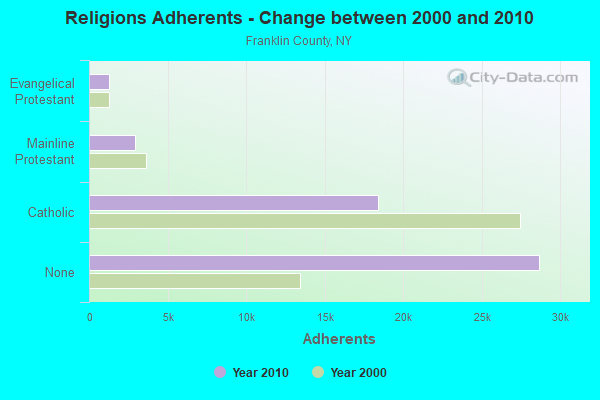
| Religion | Adherents | Congregations |
|---|---|---|
| Catholic | 18,437 | 21 |
| Mainline Protestant | 2,942 | 26 |
| Evangelical Protestant | 1,277 | 19 |
| Other | 253 | 4 |
| None | 28,690 | - |
Food Environment Statistics:
| Franklin County: | 3.57 / 10,000 pop. |
| New York: | 4.13 / 10,000 pop. |
| This county: | 1.39 / 10,000 pop. |
| New York: | 0.92 / 10,000 pop. |
| Franklin County: | 4.96 / 10,000 pop. |
| State: | 1.68 / 10,000 pop. |
| Franklin County: | 6.94 / 10,000 pop. |
| New York: | 8.82 / 10,000 pop. |
| Here: | 8.2% |
| New York: | 8.2% |
| This county: | 26.3% |
| New York: | 23.8% |
| This county: | 13.7% |
| State: | 15.6% |
Strongest AM radio stations in Bellmont:
- WICY (1490 AM; 50 kW; MALONE, NY; Owner: CARTIER COMMUNICATIONS INC.)
- WCHP (760 AM; 35 kW; CHAMPLAIN, NY; Owner: CHAMPLAIN RADIO, INC.)
- WIRD (920 AM; 5 kW; LAKE PLACID, NY; Owner: RADIO LAKE PLACID INC)
- WEAV (960 AM; 5 kW; PLATTSBURGH, NY; Owner: CLEAR CHANNEL BROADCASTING LICENSES, INC.)
- WTWK (1070 AM; daytime; 5 kW; PLATTSBURGH, NY; Owner: CHAMPLAIN COMMUNICATIONS CORPORATION)
- WVMT (620 AM; 5 kW; BURLINGTON, VT; Owner: SISON BROADCASTING, INC.)
- WGY (810 AM; 50 kW; SCHENECTADY, NY; Owner: CLEAR CHANNEL BROADCASTING LICENSES, INC.)
- WNNZ (640 AM; 50 kW; WESTFIELD, MA; Owner: CLEAR CHANNEL BROADCASTING LICENSES, INC.)
- WPTR (1540 AM; 50 kW; ALBANY, NY; Owner: KIMTRON, INC.)
- WVAA (1390 AM; 5 kW; BURLINGTON, VT; Owner: RADIO VERMONT, KDR, LLC)
- WDEV (550 AM; 5 kW; WATERBURY, VT; Owner: RADIO VERMONT, INC.)
- WRKO (680 AM; 50 kW; BOSTON, MA; Owner: ENTERCOM BOSTON LICENSE, LLC)
- WCRN (830 AM; 50 kW; WORCESTER, MA; Owner: CARTER BROADCASTING CORPORATION)
Strongest FM radio stations in Bellmont:
- WYUL (94.7 FM; CHATEAUGAY, NY; Owner: CARTIER COMMUNICATIONS INC.)
- WVNV (96.5 FM; MALONE, NY; Owner: CARTIER COMMUNICATIONS INC.)
- WCEL (91.9 FM; PLATTSBURGH, NY; Owner: WAMC)
- WXLU (88.3 FM; PERU, NY; Owner: THE ST. LAWRENCE UNIVERSITY)
- WBTZ (99.9 FM; PLATTSBURGH, NY; Owner: PLATTSBURGH BROADCASTING CORPORATION)
- WEZF (92.9 FM; BURLINGTON, VT; Owner: CAPSTAR TX LIMITED PARTNERSHIP)
- WVPS (107.9 FM; BURLINGTON, VT; Owner: VERMONT PUBLIC RADIO)
- WSLO (90.9 FM; MALONE, NY; Owner: THE ST. LAWRENCE UNIVERSITY)
- WCVT (101.7 FM; STOWE, VT; Owner: RADIO VERMONT CLASSICS, L.L.C.)
- WLKC (103.3 FM; WATERBURY, VT; Owner: RADIO BROADCASTING SERVICES, INC.)
- WRGR (102.3 FM; TUPPER LAKE, NY; Owner: RADIO LAKE PLACID, INC.)
- WSLL (90.5 FM; SARANAC LAKE, NY; Owner: THE ST. LAWRENCE UNIVERSITY)
- WYZY (106.3 FM; SARANAC LAKE, NY; Owner: SARANAC LAKE RADIO, L.L.C.)
TV broadcast stations around Bellmont:
- W49BI (Channel 49; ELLENBURG, NY; Owner: PLATTSBURGH PARTNERS)
- WCFE-TV (Channel 57; PLATTSBURGH, NY; Owner: MOUNTAIN LAKE PUBLIC TELEVISION COUNCIL)
- WPTZ (Channel 5; NORTH POLE, NY; Owner: HEARST-ARGYLE STATIONS, INC.)
- National Bridge Inventory (NBI) Statistics
- 13Number of bridges
- 66ft / 20.2mTotal length
- $7,592,000Total costs
- 10,055Total average daily traffic
- 897Total average daily truck traffic
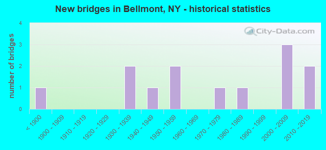
- New bridges - historical statistics
- 1Before 1900
- 21930-1939
- 11940-1949
- 21950-1959
- 11970-1979
- 11980-1989
- 32000-2009
- 22010-2019
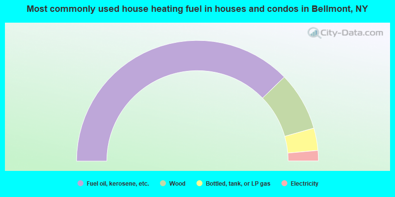
- 75.5%Fuel oil, kerosene, etc.
- 15.7%Wood
- 6.0%Bottled, tank, or LP gas
- 2.8%Electricity
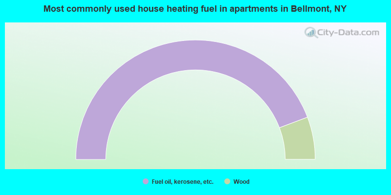
- 88.5%Fuel oil, kerosene, etc.
- 11.5%Wood
Bellmont compared to New York state average:
- Median house value significantly below state average.
- Unemployed percentage below state average.
- Black race population percentage significantly below state average.
- Hispanic race population percentage significantly below state average.
- Median age above state average.
- Foreign-born population percentage significantly below state average.
- Renting percentage significantly below state average.
- Length of stay since moving in significantly above state average.
- Number of rooms per house significantly below state average.
- House age significantly below state average.
- Number of college students below state average.
- Percentage of population with a bachelor's degree or higher below state average.