Bakerville-Bold Spring, Tennessee
Submit your own pictures of this place and show them to the world
- OSM Map
- Google Map
- MSN Map
| Males: 1,373 | |
| Females: 1,290 |
| Median resident age: | 37.9 years |
| Tennessee median age: | 35.9 years |
Zip code: 37078
| Bakerville-Bold Spring: | $54,487 |
| TN: | $65,254 |
Estimated per capita income in 2022: $26,701 (it was $15,749 in 2000)
Bakerville-Bold Spring CCD income, earnings, and wages data
Estimated median house or condo value in 2022: $208,071 (it was $73,100 in 2000)
| Bakerville-Bold Spring: | $208,071 |
| TN: | $284,800 |
Bakerville-Bold Spring, TN residents, houses, and apartments details
Detailed information about poverty and poor residents in Bakerville-Bold Spring, TN
Compare current foreclosures near your location:
| Photo | Address | Area | Beds / Baths | Price | Details |
|---|---|---|---|---|---|

|
#1
Bayberry Cir
Columbus, OH 43207
|
1,564 sq. feet
|
1 baths 3 beds |
$127,500
|
show details |

|
#2
S High St
Columbus, OH 43207
|
1,678 sq. feet
|
2 baths 4 beds |
$27,500
|
show details |

|
#3
E 21st Ave
Columbus, OH 43211
|
1,061 sq. feet
|
1 baths 3 beds |
$179,900
|
show details |

|
#4
Chester Rd
Columbus, OH 43221
|
3,300 sq. feet
|
4 baths 5 beds |
show details | |

|
#5
Glenmate Ct
Columbus, OH 43223
|
1,050 sq. feet
|
1 baths 3 beds |
show details | |

|
#6
E Lincoln Ave
Columbus, OH 43214
|
874 sq. feet
|
1 baths 3 beds |
show details | |

|
#7
Fergus Rd
Grove City, OH 43123
|
3,312 sq. feet
|
2 baths 4 beds |
show details | |

|
#8
Cannonade Ct
Columbus, OH 43230
|
2,023 sq. feet
|
2 baths 3 beds |
show details | |

|
#9
S Champion Ave
Columbus, OH 43207
|
1,157 sq. feet
|
1 baths 2 beds |
show details | |

|
#10
E Welch Ave
Columbus, OH 43207
|
1,864 sq. feet
|
2 baths 4 beds |
show details |
| Photo | Address | Area | Beds / Baths | Price | Details |
|---|---|---|---|---|---|

|
#11
Upton Rd E
Columbus, OH 43232
|
852 sq. feet
|
1 baths 3 beds |
show details | |

|
#12
Fairfield Ave
Columbus, OH 43203
|
984 sq. feet
|
1 baths 2 beds |
show details | |

|
#13
E Howard Rd
Columbus, OH 43207
|
1,056 sq. feet
|
1 baths 3 beds |
show details | |

|
#14
Safford Ave
Columbus, OH 43223
|
784 sq. feet
|
1 baths 2 beds |
show details | |

|
#15
Hiawatha Park Dr
Columbus, OH 43211
|
1,278 sq. feet
|
1 baths 4 beds |
show details | |

|
#16
Lehner Rd
Columbus, OH 43224
|
1,628 sq. feet
|
2 baths 4 beds |
show details | |

|
#17
Summertree Ln
Westerville, OH 43081
|
2,496 sq. feet
|
2 baths 3 beds |
show details | |

|
#18
Wrexham Ave
Columbus, OH 43223
|
1,235 sq. feet
|
1 baths 3 beds |
show details | |

|
#19
N Roys Ave
Columbus, OH 43204
|
648 sq. feet
|
2 baths 3 beds |
show details | |

|
#20
Armada Rd
Columbus, OH 43232
|
1,028 sq. feet
|
1 baths 4 beds |
show details |
| Photo | Address | Area | Beds / Baths | Price | Details |
|---|---|---|---|---|---|

|
#21
Chidley St
Galloway, OH 43119
|
1,502 sq. feet
|
1 baths 3 beds |
show details | |

|
#22
N Roys Ave
Columbus, OH 43204
|
1,248 sq. feet
|
2 baths 3 beds |
show details | |

|
#23
London Groveport Rd
Grove City, OH 43123
|
816 sq. feet
|
1 baths 2 beds |
show details | |

|
#24
Executive Ct
Westerville, OH 43081
|
1,811 sq. feet
|
2 baths 3 beds |
show details | |

|
#25
High Free Pike
West Jefferson, OH 43162
|
1,216 sq. feet
|
2 baths 4 beds |
show details | |

|
#26
Meadowbrook Dr
Columbus, OH 43207
|
1,752 sq. feet
|
2 baths 4 beds |
show details | |

|
#27
Roundelay Rd N
Reynoldsburg, OH 43068
|
1,712 sq. feet
|
2 baths 3 beds |
show details | |

|
#28
Rosewood Ct
Powell, OH 43065
|
2,801 sq. feet
|
3 baths 4 beds |
show details | |

|
#29
Gladys Rd
Columbus, OH 43228
|
832 sq. feet
|
1 baths 3 beds |
show details | |

|
#30
Hildreth Ave
Columbus, OH 43203
|
1,798 sq. feet
|
2 baths 4 beds |
show details |
| Photo | Address | Area | Beds / Baths | Price | Details |
|---|---|---|---|---|---|

|
#31
Plainview Dr
Columbus, OH 43204
|
730 sq. feet
|
1 baths 2 beds |
show details | |

|
#32
Hamilton Ave
Columbus, OH 43211
|
1,061 sq. feet
|
1 baths 3 beds |
show details | |

|
#33
Ashgrove Dr
Grove City, OH 43123
|
1,772 sq. feet
|
2 baths 4 beds |
show details | |

|
#34
S Richardson Ave
Columbus, OH 43204
|
1,520 sq. feet
|
2 baths 3 beds |
show details | |

|
#35
Whittman Ct
Plain City, OH 43064
|
3,186 sq. feet
|
3 baths 4 beds |
show details | |

|
#36
Kelton Ave
Columbus, OH 43206
|
1,080 sq. feet
|
1 baths 3 beds |
show details | |

|
#37
Striebel Ct
Columbus, OH 43227
|
925 sq. feet
|
1 baths 3 beds |
show details | |

|
#38
Falls Peak Ln
Delaware, OH 43015
|
1,352 sq. feet
|
2 baths 2 beds |
show details | |

|
#39
N 18th St
Columbus, OH 43203
|
1,690 sq. feet
|
1 baths 4 beds |
show details | |

|
#40
Grasmere Ave
Columbus, OH 43211
|
720 sq. feet
|
1 baths 2 beds |
show details |
| Photo | Address | Area | Beds / Baths | Price | Details |
|---|---|---|---|---|---|

|
#41
Edgeview Rd
Columbus, OH 43207
|
1,352 sq. feet
|
1 baths 4 beds |
show details | |

|
#42
Gertrude Dr
Columbus, OH 43227
|
1,287 sq. feet
|
1 baths 3 beds |
show details | |

|
#43
Huxley Dr
Columbus, OH 43227
|
1,284 sq. feet
|
1 baths 3 beds |
show details | |

|
#44
Grand Bend Dr
Groveport, OH 43125
|
1,612 sq. feet
|
1 baths 3 beds |
show details | |

|
#45
Sapphire Dr
Grove City, OH 43123
|
3,241 sq. feet
|
3 baths 4 beds |
show details | |

|
#46
Torchwood Loop E
Columbus, OH 43229
|
2,116 sq. feet
|
2 baths 4 beds |
show details | |

|
#47
Justin Rd
Columbus, OH 43227
|
986 sq. feet
|
1 baths 3 beds |
show details | |

|
#48
Wendler Blvd
Columbus, OH 43230
|
1,040 sq. feet
|
1 baths 3 beds |
show details | |

|
#49
Beechview Dr S
Columbus, OH 43085
|
1,998 sq. feet
|
1 baths 3 beds |
show details | |

|
Check over 1 million property listings on Foreclosure.com!
|
browse all offers | |||

- 2,49095.3%White alone
- 461.8%Black alone
- 281.1%Two or more races
- 301.1%Hispanic
- 150.6%Asian alone
- 30.1%American Indian alone
- 10.04%Other race alone

Races in Bakerville-Bold Spring detailed stats: ancestries, foreign born residents, place of birth
 Recent articles from our blog. Our writers, many of them Ph.D. graduates or candidates, create easy-to-read articles on a wide variety of topics.
Current Local Time: CST time zone
Land area: 241.0 square miles.
Population density: 11 people per square mile (very low).
| Bakerville-Bold Spring CCD: | 0.5% ($347) |
| Tennessee: | 0.8% ($715) |
Nearest city with pop. 50,000+: Clarksville, TN  (48.2 miles , pop. 103,455).
Nearest city with pop. 200,000+: Metropolitan Government, TN (57.5 miles , pop. 569,891).
Nearest city with pop. 1,000,000+: Chicago, IL (408.0 miles , pop. 2,896,016).
Nearest cities:
), ), ), ), )Latitude: 35.94 N, Longitude: 87.76 W
Area code commonly used in this area: 931

| Here: | 3.1% |
| Tennessee: | 3.0% |

- Construction (11.4%)
- Accommodation & food services (6.4%)
- Chemicals (6.2%)
- Metal & metal products (5.8%)
- Public administration (5.2%)
- Transportation equipment (4.4%)
- Health care (3.8%)

- Construction (18.2%)
- Chemicals (7.5%)
- Metal & metal products (7.0%)
- Transportation equipment (6.5%)
- Accommodation & food services (5.5%)
- Public administration (4.9%)
- Utilities (4.3%)

- Health care (8.9%)
- Educational services (8.2%)
- Accommodation & food services (7.7%)
- Leather & allied products (7.3%)
- Public administration (5.5%)
- Chemicals (4.5%)
- Food & beverage stores (4.3%)

- Other production occupations, including supervisors (8.3%)
- Electrical equipment mechanics and other installation, maintenance, and repair workers, including supervisors (5.8%)
- Vehicle and mobile equipment mechanics, installers, and repairers (3.9%)
- Driver/sales workers and truck drivers (3.8%)
- Textile, apparel, and furnishings workers (3.6%)
- Building and grounds cleaning and maintenance occupations (3.6%)
- Other management occupations, except farmers and farm managers (3.4%)

- Electrical equipment mechanics and other installation, maintenance, and repair workers, including supervisors (9.6%)
- Other production occupations, including supervisors (7.5%)
- Vehicle and mobile equipment mechanics, installers, and repairers (6.9%)
- Construction traders workers except carpenters, electricians, painters, plumbers, and construction laborers (5.7%)
- Driver/sales workers and truck drivers (5.4%)
- Building and grounds cleaning and maintenance occupations (5.3%)
- Other management occupations, except farmers and farm managers (4.1%)

- Other production occupations, including supervisors (9.5%)
- Textile, apparel, and furnishings workers (8.6%)
- Secretaries and administrative assistants (7.0%)
- Information and record clerks, except customer service representatives (5.2%)
- Health technologists and technicians (4.3%)
- Material recording, scheduling, dispatching, and distributing workers (3.8%)
- Cooks and food preparation workers (3.2%)
Average climate in Bakerville-Bold Spring, Tennessee
Based on data reported by over 4,000 weather stations


(lower is better)

Air Quality Index (AQI) level in 2009 was 6.16. This is significantly better than average.
| City: | 6.16 |
| U.S.: | 72.56 |

Nitrogen Dioxide (NO2) [ppb] level in 2003 was 3.86. This is better than average. Closest monitor was 13.8 miles away from the city center.
| City: | 3.86 |
| U.S.: | 5.11 |

Sulfur Dioxide (SO2) [ppb] level in 2009 was 1.49. This is about average. Closest monitor was 10.7 miles away from the city center.
| City: | 1.49 |
| U.S.: | 1.51 |

Ozone [ppb] level in 2003 was 33.2. This is about average. Closest monitor was 13.8 miles away from the city center.
| City: | 33.2 |
| U.S.: | 33.3 |
Tornado activity:
Bakerville-Bold Spring-area historical tornado activity is slightly above Tennessee state average. It is 70% greater than the overall U.S. average.
On 5/7/1971, a category F4 (max. wind speeds 207-260 mph) tornado 9.0 miles away from the Bakerville-Bold Spring place center killed 3 people and injured 137 people and caused between $500,000 and $5,000,000 in damages.
On 5/5/1999, a category F4 tornado 22.0 miles away from the place center killed 3 people and caused $290,000 in damages.
Earthquake activity:
Bakerville-Bold Spring-area historical earthquake activity is significantly above Tennessee state average. It is 258% greater than the overall U.S. average.On 4/18/2008 at 09:36:59, a magnitude 5.4 (5.1 MB, 4.8 MS, 5.4 MW, 5.2 MW, Class: Moderate, Intensity: VI - VII) earthquake occurred 173.7 miles away from the city center
On 5/4/1991 at 01:18:54, a magnitude 5.0 (4.4 MB, 4.6 LG, 5.0 LG, Depth: 3.1 mi) earthquake occurred 122.8 miles away from Bakerville-Bold Spring center
On 9/26/1990 at 13:18:51, a magnitude 5.0 (4.7 MB, 4.8 LG, 5.0 LG, Depth: 7.7 mi) earthquake occurred 130.0 miles away from the city center
On 4/18/2008 at 09:36:59, a magnitude 5.2 (5.2 MW, Depth: 8.9 mi) earthquake occurred 173.7 miles away from the city center
On 6/18/2002 at 17:37:15, a magnitude 5.0 (4.3 MB, 4.6 MW, 5.0 LG) earthquake occurred 141.4 miles away from Bakerville-Bold Spring center
On 3/25/1976 at 00:41:20, a magnitude 5.0 (4.9 MB, 5.0 LG) earthquake occurred 145.6 miles away from the city center
Magnitude types: regional Lg-wave magnitude (LG), body-wave magnitude (MB), surface-wave magnitude (MS), moment magnitude (MW)
Natural disasters:
The number of natural disasters in Humphreys County (19) is greater than the US average (15).Major Disasters (Presidential) Declared: 15
Emergencies Declared: 1
Causes of natural disasters: Storms: 16, Floods: 14, Tornadoes: 9, Winds: 6, Flash Flood: 1, Hurricane: 1, Ice Storm: 1, Landslide: 1, Mudslide: 1, Winter Storm: 1, Other: 1 (Note: some incidents may be assigned to more than one category).
Colleges/universities with over 2000 students nearest to Bakerville-Bold Spring:
- Columbia State Community College (about 44 miles; Columbia, TN; Full-time enrollment: 3,383)
- Bethel University (about 45 miles; McKenzie, TN; FT enrollment: 5,878)
- Austin Peay State University (about 47 miles; Clarksville, TN; FT enrollment: 8,621)
- Nashville State Community College (about 53 miles; Nashville, TN; FT enrollment: 6,436)
- Tennessee State University (about 55 miles; Nashville, TN; FT enrollment: 7,341)
- Lipscomb University (about 55 miles; Nashville, TN; FT enrollment: 3,827)
- Vanderbilt University (about 56 miles; Nashville, TN; FT enrollment: 10,518)
Points of interest:
Notable locations in Bakerville-Bold Spring: Piedmont Landing (A), Dixie Landing (B), Cuba Landing Marina (C), Sycamore Landing (D), Cuba Landing (E), Humphreys County Fire Department District 6 (F), Bold Springs - Poplar Grove Volunteer Fire Department (G). Display/hide their locations on the map
Churches in Bakerville-Bold Spring include: Glenwood United Methodist Church (A), Pruett Chapel (B), Liberty Church (C), Bold Springs Church of Christ (D), Poplar Grove Church of Christ (E), New Hope Methodist Church (F), Wills Chapel (G), Indian Creek Church (H), Beech Grove Church (I). Display/hide their locations on the map
Cemeteries: Sanders Cemetery (1), Taylor Cemetery (2), Scurlock Cemetery (3), James Cemetery (4), Shannon Cemetery (5), Tubbs Cemetery (6), Johnson Cemetery (7). Display/hide their locations on the map
Lakes and reservoirs: Big Spring Lake (A), Whery Lake (B), Parm Lick Pond (C), Big Spring Lake Number Two (D). Display/hide their locations on the map
Streams, rivers, and creeks: Luten Branch (A), Beason Branch (B), Jack Branch (C), Indian Creek (D), Grassy Branch (E), Duncan Branch (F), Cold Branch (G), Clear Creek (H), Clear Branch (I). Display/hide their locations on the map
Park in Bakerville-Bold Spring: Hugh Link Farm State Archaeological Area (1). Display/hide its location on the map
| This place: | 2.6 people |
| Tennessee: | 2.5 people |
| This place: | 60.6% |
| Whole state: | 69.8% |
| This place: | 5.4% |
| Whole state: | 4.2% |
Likely homosexual households (counted as self-reported same-sex unmarried-partner households)
- Lesbian couples: 0.2% of all households
- Gay men: 0.2% of all households
| This place: | 9.2% |
| Whole state: | 13.5% |
| This place: | 2.6% |
| Whole state: | 5.8% |
For population 15 years and over in Bakerville-Bold Spring:

- Never married: 17.4%
- Now married: 65.3%
- Separated: 1.8%
- Widowed: 8.0%
- Divorced: 9.4%
For population 25 years and over in Bakerville-Bold Spring:
- High school or higher: 70.5%
- Bachelor's degree or higher: 5.9%
- Graduate or professional degree: 2.7%
- Unemployed: 3.7%
- Mean travel time to work (commute): 32.3 minutes


| Here: | 8.7 |
| Tennessee average: | 13.3 |
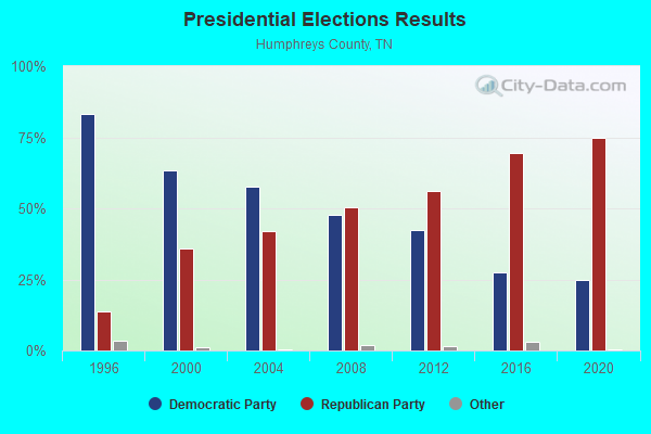
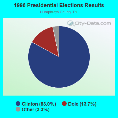
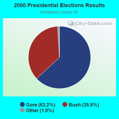
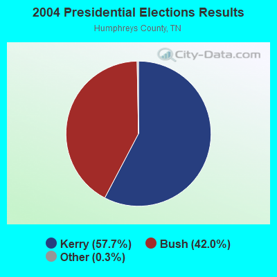
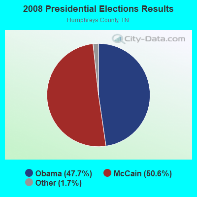
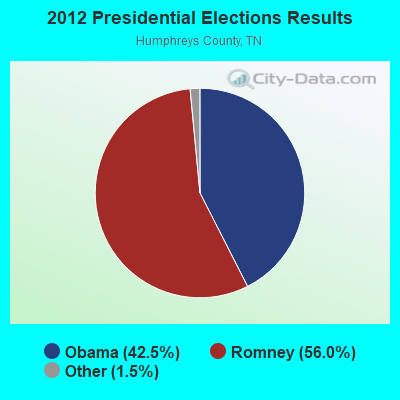
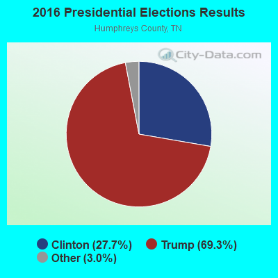
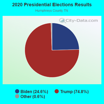
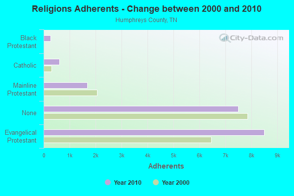
Graphs represent county-level data. Detailed 2008 Election Results
Religion statistics for Bakerville-Bold Spring, TN (based on Humphreys County data)
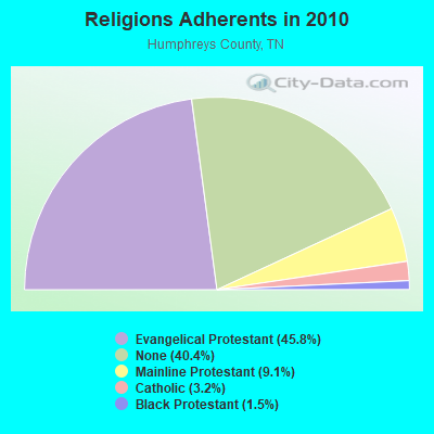
| Religion | Adherents | Congregations |
|---|---|---|
| Evangelical Protestant | 8,494 | 48 |
| Mainline Protestant | 1,687 | 11 |
| Catholic | 600 | 1 |
| Black Protestant | 271 | 2 |
| Other | - | - |
| None | 7,486 | - |
Food Environment Statistics:
| Humphreys County: | 2.20 / 10,000 pop. |
| Tennessee: | 1.99 / 10,000 pop. |
| Humphreys County: | 0.55 / 10,000 pop. |
| Tennessee: | 0.65 / 10,000 pop. |
| Humphreys County: | 5.51 / 10,000 pop. |
| State: | 5.16 / 10,000 pop. |
| Here: | 9.37 / 10,000 pop. |
| State: | 6.56 / 10,000 pop. |
| This county: | 13.0% |
| Tennessee: | 11.4% |
| Humphreys County: | 30.0% |
| Tennessee: | 30.2% |
| This county: | 13.1% |
| State: | 13.5% |
Strongest AM radio stations in Bakerville-Bold Spring:
- WSM (650 AM; 50 kW; NASHVILLE, TN; Owner: GAYLORD ENTERTAINMENT COMPANY)
- WKDA (1200 AM; 50 kW; NASHVILLE, TN; Owner: RADIO NASHVILLE, INC.)
- WNQM (1300 AM; 50 kW; NASHVILLE, TN; Owner: WNQM. INC.)
- WAMB (1160 AM; 50 kW; DONELSON, TN; Owner: GREAT SOUTHERN BROADCASTING COMPANY, INC.)
- WLAC (1510 AM; 50 kW; NASHVILLE, TN; Owner: CAPSTAR TX LIMITED PARTNERSHIP)
- WPHC (1060 AM; daytime; 1 kW; WAVERLY, TN)
- WNKX (1570 AM; 5 kW; CENTERVILLE, TN; Owner: HICKMAN COUNTY BROADCASTING CO., INC.)
- WDKN (1260 AM; 5 kW; DICKSON, TN; Owner: EDMISSON & EUBANK COMMUNICATIONS, INC.)
- WCRV (640 AM; 50 kW; COLLIERVILLE, TN; Owner: BOTT BROADCASTING COMPANY/TENNESSEE)
- WWAM (820 AM; daytime; 50 kW; JASPER, TN; Owner: SHELTON BROADCASTING SYSTEM)
- WLOR (1550 AM; 50 kW; HUNTSVILLE, AL; Owner: BCA RADIO, LLC)
- WMUF (1000 AM; daytime; 5 kW; PARIS, TN; Owner: BENTON-WEATHERFORD B/CTING OF TN,INC)
- WPLN (1430 AM; 15 kW; MADISON, TN)
Strongest FM radio stations in Bakerville-Bold Spring:
- WAYW (89.9 FM; NEW JOHNSONVILLE, TN; Owner: WAY-FM MEDIA GROUP, INC.)
- WFGZ (94.5 FM; LOBELVILLE, TN; Owner: OHIO BROADCAST ASSOCIATES)
- WVRY (105.1 FM; WAVERLY, TN; Owner: REACH SATELLITE NETWORK, INC.)
- WNKX-FM (96.7 FM; CENTERVILLE, TN; Owner: HICKMAN COUNTY BROADCASTING CO., INC.)
- WQZQ-FM (102.5 FM; DICKSON, TN; Owner: MONTGOMERY BROADCASTING COMPANY)
- WTPR-FM (101.5 FM; MCKINNON, TN; Owner: WENK BROADCAST GROUP)
- WNRZ (91.5 FM; DICKSON, TN; Owner: TREVECCA NAZARENE UNIVERSITY, INC.)
- WCVQ (107.9 FM; FORT CAMPBELL, KY; Owner: SAGA COMMUNICATIONS OF TUCKESSEE, LLC)
- WRJB (95.9 FM; CAMDEN, TN; Owner: COMMUNITY BROADCASTING SERVICES, INC)

- 40.5%Electricity
- 38.9%Utility gas
- 11.5%Bottled, tank, or LP gas
- 8.4%Wood
- 0.6%Other fuel

- 45.7%Utility gas
- 33.2%Electricity
- 6.5%Bottled, tank, or LP gas
- 6.5%Wood
- 5.4%Other fuel
- 2.7%Fuel oil, kerosene, etc.
Bakerville-Bold Spring compared to Tennessee state average:
- Unemployed percentage significantly below state average.
- Black race population percentage significantly below state average.
- Hispanic race population percentage significantly below state average.
- Foreign-born population percentage significantly below state average.
- Renting percentage significantly below state average.
- Length of stay since moving in significantly above state average.
- Number of rooms per house significantly below state average.
- House age significantly below state average.
- Number of college students significantly below state average.
- Percentage of population with a bachelor's degree or higher significantly below state average.
Bakerville-Bold Spring on our top lists:
- #82 on the list of "Top 101 cities with the largest percentage of people in other group homes (population 1,000+)"