Bakerstown, Tennessee
Submit your own pictures of this place and show them to the world
- OSM Map
- General Map
- Google Map
- MSN Map

| Males: 1,784 | |
| Females: 1,736 |
| Median resident age: | 37.5 years |
| Tennessee median age: | 35.9 years |
Zip code: 37352
| Bakerstown: | $73,990 |
| TN: | $65,254 |
Estimated per capita income in 2022: $36,887 (it was $19,604 in 2000)
Bakerstown CCD income, earnings, and wages data
Estimated median house or condo value in 2022: $304,802 (it was $86,800 in 2000)
| Bakerstown: | $304,802 |
| TN: | $284,800 |
Mean prices in 2022: all housing units: $298,209; detached houses: $318,808; mobile homes: $102,637
Detailed information about poverty and poor residents in Bakerstown, TN


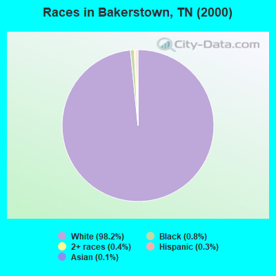
- 3,30098.2%White alone
- 260.8%Black alone
- 150.4%Two or more races
- 100.3%Hispanic
- 50.1%Asian alone
- 30.09%American Indian alone
Races in Bakerstown detailed stats: ancestries, foreign born residents, place of birth
 Recent articles from our blog. Our writers, many of them Ph.D. graduates or candidates, create easy-to-read articles on a wide variety of topics.
Current Local Time: CST time zone
Land area: 72.3 square miles.
Population density: 49 people per square mile (very low).

| Bakerstown CCD: | 0.5% ($429) |
| Tennessee: | 0.8% ($715) |
Nearest city with pop. 50,000+: Huntsville, AL  (41.1 miles , pop. 158,216).
Nearest city with pop. 200,000+: Nashville-Davidson, TN (66.5 miles , pop. 545,524).
Nearest city with pop. 1,000,000+: Chicago, IL (460.9 miles , pop. 2,896,016).
Nearest cities:
), ), ), ), Latitude: 35.26 N, Longitude: 86.32 W
Area code commonly used in this area: 931

| Here: | 2.1% |
| Tennessee: | 3.0% |
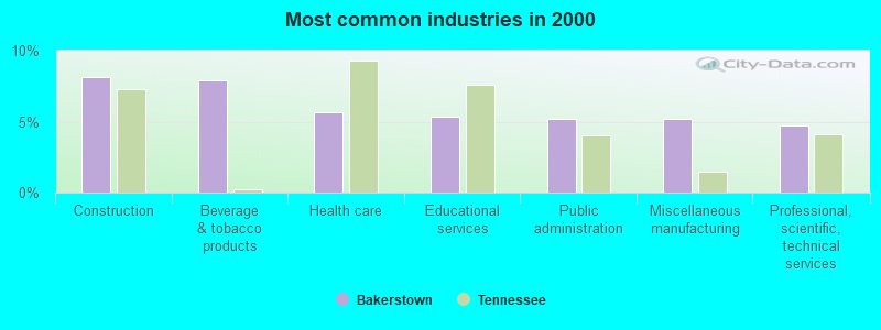
- Construction (8.2%)
- Beverage & tobacco products (7.9%)
- Health care (5.6%)
- Educational services (5.3%)
- Public administration (5.2%)
- Miscellaneous manufacturing (5.2%)
- Professional, scientific, technical services (4.7%)
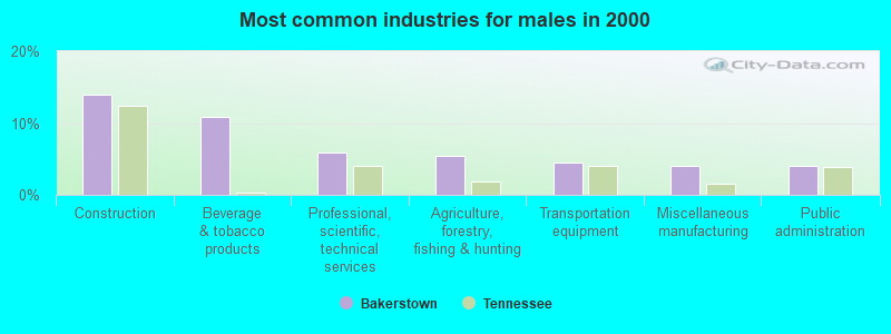
- Construction (14.0%)
- Beverage & tobacco products (10.9%)
- Professional, scientific, technical services (6.0%)
- Agriculture, forestry, fishing & hunting (5.4%)
- Transportation equipment (4.6%)
- Miscellaneous manufacturing (4.1%)
- Public administration (4.1%)
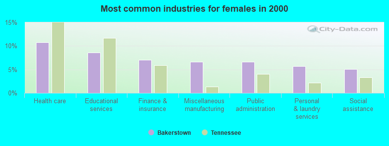
- Health care (10.8%)
- Educational services (8.6%)
- Finance & insurance (7.0%)
- Miscellaneous manufacturing (6.6%)
- Public administration (6.6%)
- Personal & laundry services (5.7%)
- Social assistance (5.1%)
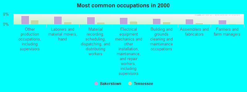
- Other production occupations, including supervisors (6.7%)
- Laborers and material movers, hand (6.4%)
- Material recording, scheduling, dispatching, and distributing workers (5.9%)
- Electrical equipment mechanics and other installation, maintenance, and repair workers, including supervisors (5.3%)
- Building and grounds cleaning and maintenance occupations (4.5%)
- Assemblers and fabricators (4.1%)
- Farmers and farm managers (3.3%)
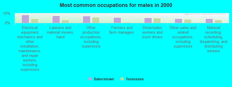
- Electrical equipment mechanics and other installation, maintenance, and repair workers, including supervisors (8.5%)
- Laborers and material movers, hand (7.5%)
- Other production occupations, including supervisors (7.1%)
- Farmers and farm managers (5.6%)
- Driver/sales workers and truck drivers (5.5%)
- Other sales and related occupations, including supervisors (4.7%)
- Material recording, scheduling, dispatching, and distributing workers (4.6%)
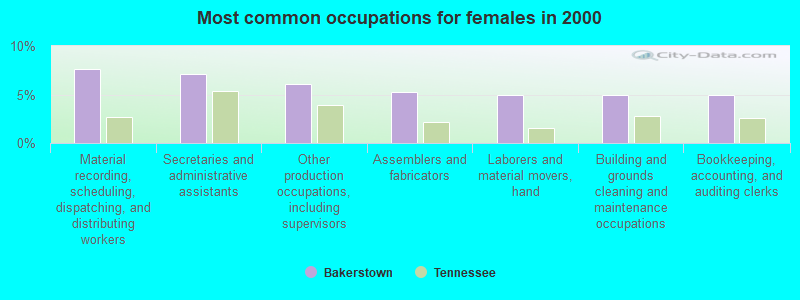
- Material recording, scheduling, dispatching, and distributing workers (7.6%)
- Secretaries and administrative assistants (7.2%)
- Other production occupations, including supervisors (6.1%)
- Assemblers and fabricators (5.3%)
- Laborers and material movers, hand (5.0%)
- Building and grounds cleaning and maintenance occupations (5.0%)
- Bookkeeping, accounting, and auditing clerks (5.0%)
Average climate in Bakerstown, Tennessee
Based on data reported by over 4,000 weather stations


Tornado activity:
Bakerstown-area historical tornado activity is slightly above Tennessee state average. It is 99% greater than the overall U.S. average.
On 4/3/1974, a category F5 (max. wind speeds 261-318 mph) tornado 24.5 miles away from the Bakerstown place center killed 16 people and injured 190 people.
On 2/13/1952, a category F4 (max. wind speeds 207-260 mph) tornado 4.5 miles away from the place center killed 3 people and injured 44 people and caused between $50,000 and $500,000 in damages.
Earthquake activity:
Bakerstown-area historical earthquake activity is significantly above Tennessee state average. It is 162% greater than the overall U.S. average.On 4/29/2003 at 08:59:39, a magnitude 4.9 (4.4 MB, 4.6 MW, 4.9 LG, Class: Light, Intensity: IV - V) earthquake occurred 66.1 miles away from the city center
On 4/29/2003 at 08:59:39, a magnitude 4.6 (4.6 MW, Depth: 12.3 mi) earthquake occurred 66.0 miles away from Bakerstown center
On 4/18/2008 at 09:36:59, a magnitude 5.4 (5.1 MB, 4.8 MS, 5.4 MW, 5.2 MW, Class: Moderate, Intensity: VI - VII) earthquake occurred 237.0 miles away from the city center
On 1/18/1999 at 07:00:53, a magnitude 4.8 (4.8 MB, 4.0 LG, Depth: 0.6 mi) earthquake occurred 139.1 miles away from the city center
On 11/30/1973 at 07:48:41, a magnitude 4.7 (4.7 MB, 4.6 ML) earthquake occurred 137.9 miles away from Bakerstown center
On 4/18/2008 at 09:36:59, a magnitude 5.2 (5.2 MW, Depth: 8.9 mi) earthquake occurred 237.0 miles away from the city center
Magnitude types: regional Lg-wave magnitude (LG), body-wave magnitude (MB), local magnitude (ML), surface-wave magnitude (MS), moment magnitude (MW)
Natural disasters:
The number of natural disasters in Moore County (11) is smaller than the US average (15).Major Disasters (Presidential) Declared: 7
Emergencies Declared: 2
Causes of natural disasters: Floods: 6, Storms: 4, Winter Storms: 4, Tornadoes: 3, Winds: 2, Flash Flood: 1, Heavy Rain: 1, Hurricane: 1, Ice Storm: 1, Landslide: 1, Mudslide: 1, Snowfall: 1, Other: 1 (Note: some incidents may be assigned to more than one category).
Hospitals and medical centers near Bakerstown:
- LYNCHBURG NURSING CENTER (Nursing Home, about 4 miles away; LYNCHBURG, TN)
- HOSPICE OF THE HIGHLAND RIM (Hospital, about 10 miles away; TULLAHOMA, TN)
- RCG TULLAHOMA (Dialysis Facility, about 10 miles away; TULLAHOMA, TN)
- LIFE CARE CENTER OF TULLAHOMA (Nursing Home, about 10 miles away; TULLAHOMA, TN)
- HARTON REGIONAL MEDICAL CENTER Acute Care Hospitals (about 10 miles away; TULLAHOMA, TN)
- MEDICAL HOME HEALTH CARE (Home Health Center, about 10 miles away; TULLAHOMA, TN)
- AMEDISYS HOME CARE (Home Health Center, about 13 miles away; WINCHESTER, TN)
Colleges/universities with over 2000 students nearest to Bakerstown:
- Motlow State Community College (about 8 miles; Tullahoma, TN; Full-time enrollment: 2,915)
- Alabama A & M University (about 36 miles; Normal, AL; FT enrollment: 4,524)
- Middle Tennessee State University (about 41 miles; Murfreesboro, TN; FT enrollment: 21,628)
- University of Alabama in Huntsville (about 42 miles; Huntsville, AL; FT enrollment: 6,006)
- Athens State University (about 49 miles; Athens, AL; FT enrollment: 2,771)
- Columbia State Community College (about 51 miles; Columbia, TN; FT enrollment: 3,383)
- Northeast Alabama Community College (about 55 miles; Rainsville, AL; FT enrollment: 2,409)
Points of interest:
Notable locations in Bakerstown: Holiday Hide-A-Way Cabin Site (A), Metro Lynchburg Moore County Volunteer Fire Department Station 2 Fuga (B), Metro Lynchburg Moore County Volunteer Fire Department Station 3 Tankersley Ridge (C). Display/hide their locations on the map
Churches in Bakerstown include: Marble Hill United Methodist Church (A), Pleasant Hill United Methodist Church (B), Hickory Hill Baptist Church (C), Smith Chapel (D), Turkey Creek Church (E), Chestnut Ridge Church (F), Hoover Grove Church (G), Raysville Church (H), Calvary Church (I). Display/hide their locations on the map
Cemeteries: Sawyer Cemetery (1), Tipps Cemetery (2), Travis Cemetery (3), Union Cemetery (4), Waggoner Cemetery (5), Walker Cemetery (6), Waller Cemetery (7). Display/hide their locations on the map
Reservoir: Cumberland Springs Lake (A). Display/hide its location on the map
Streams, rivers, and creeks: Goose Branch (A), Farris Creek (B), Bobo Creek (C), Short Creek (D), Bear Branch (E), Pitts Branch (F), Turkey Creek (G), Bull Run (H), Tankersley Branch (I). Display/hide their locations on the map
Park in Bakerstown: Lost Creek Public Use Area (1). Display/hide its location on the map
| This place: | 2.6 people |
| Tennessee: | 2.5 people |
| This place: | 72.6% |
| Whole state: | 69.8% |
| This place: | 4.0% |
| Whole state: | 4.2% |
Likely homosexual households (counted as self-reported same-sex unmarried-partner households)
- Lesbian couples: 0.1% of all households
- Gay men: 0.2% of all households
| This place: | 8.4% |
| Whole state: | 13.5% |
| This place: | 3.1% |
| Whole state: | 5.8% |
For population 15 years and over in Bakerstown:
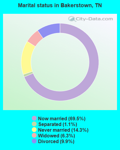
- Never married: 14.3%
- Now married: 69.5%
- Separated: 1.1%
- Widowed: 6.3%
- Divorced: 9.9%
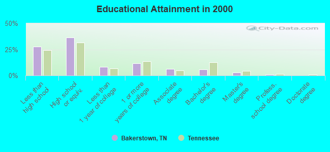
For population 25 years and over in Bakerstown:
- High school or higher: 72.5%
- Bachelor's degree or higher: 9.8%
- Graduate or professional degree: 3.8%
- Unemployed: 4.0%
- Mean travel time to work (commute): 23.6 minutes
| Here: | 11.8 |
| Tennessee average: | 13.3 |
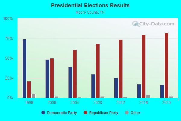
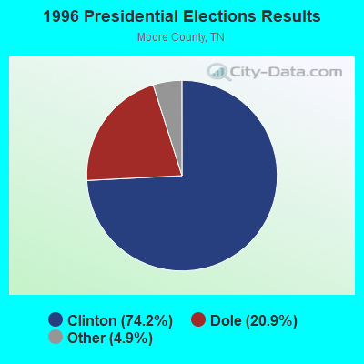
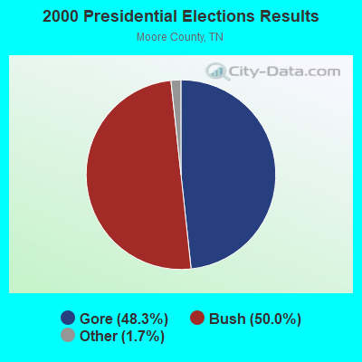

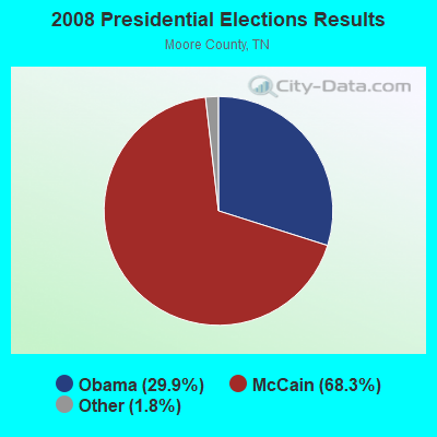
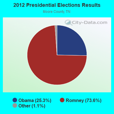
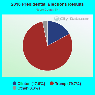

Graphs represent county-level data. Detailed 2008 Election Results
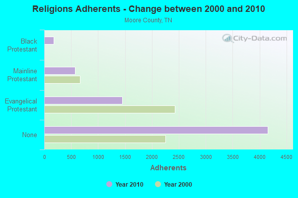
Religion statistics for Bakerstown, TN (based on Moore County data)
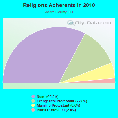
| Religion | Adherents | Congregations |
|---|---|---|
| Evangelical Protestant | 1,449 | 9 |
| Mainline Protestant | 575 | 7 |
| Black Protestant | 179 | 1 |
| Other | 3 | - |
| Catholic | - | - |
| None | 4,156 | - |
Food Environment Statistics:
| Moore County: | 3.28 / 10,000 pop. |
| State: | 5.16 / 10,000 pop. |
| Here: | 6.55 / 10,000 pop. |
| State: | 6.56 / 10,000 pop. |
| This county: | 12.2% |
| Tennessee: | 11.4% |
| Moore County: | 29.7% |
| Tennessee: | 30.2% |
| This county: | 6.2% |
| State: | 13.5% |
Strongest AM radio stations in Bakerstown:
- WWAM (820 AM; daytime; 50 kW; JASPER, TN; Owner: SHELTON BROADCASTING SYSTEM)
- WLOR (1550 AM; 50 kW; HUNTSVILLE, AL; Owner: BCA RADIO, LLC)
- WSM (650 AM; 50 kW; NASHVILLE, TN; Owner: GAYLORD ENTERTAINMENT COMPANY)
- WBXR (1140 AM; daytime; 15 kW; HAZEL GREEN, AL; Owner: LOW COUNTRY CORPORATION, INC.)
- WFLI (1070 AM; 50 kW; LOOKOUT MOUNTAIN, TN; Owner: WFLI, INC.)
- WLIJ (1580 AM; 5 kW; SHELBYVILLE, TN)
- WZYX (1440 AM; 5 kW; COWAN, TN; Owner: TIMS FORD BROADCASTING COMPANY, INC.)
- WMSR (1320 AM; 5 kW; MANCHESTER, TN; Owner: COFFEE COUNTY BROADCASTING, INC.)
- WAMB (1160 AM; 50 kW; DONELSON, TN; Owner: GREAT SOUTHERN BROADCASTING COMPANY, INC.)
- WKDA (1200 AM; 50 kW; NASHVILLE, TN; Owner: RADIO NASHVILLE, INC.)
- WNQM (1300 AM; 50 kW; NASHVILLE, TN; Owner: WNQM. INC.)
- WDJL (1000 AM; daytime; 10 kW; HUNTSVILLE, AL; Owner: JAMES K. SHARP DBA 5TH AVE BROADCASTING)
- WLAC (1510 AM; 50 kW; NASHVILLE, TN; Owner: CAPSTAR TX LIMITED PARTNERSHIP)
Strongest FM radio stations in Bakerstown:
- WUSX (93.3 FM; TULLAHOMA, TN; Owner: TENNNESSE VALLEY RADIO, INC)
- WWTN (99.7 FM; MANCHESTER, TN; Owner: CUMULUS LICENSING CORP.)
- WAHR (99.1 FM; HUNTSVILLE, AL; Owner: BCA RADIO, LLC)
- WYTM-FM (105.5 FM; FAYETTEVILLE, TN; Owner: TIME BROADCASTERS, INC.)
- W289AC (105.7 FM; HUNTSVILLE, AL; Owner: WILLIAM PAXTON ROGERS)
- WFTZ (101.5 FM; MANCHESTER, TN; Owner: PHASE TWO COMMUNICATIONS, INC.)
- WXQW (94.1 FM; MERIDIANVILLE, AL; Owner: CAPSTAR TX LIMITED PARTNERSHIP)
- W293AH (106.5 FM; NORMAL, AL; Owner: CAPSTAR TX LIMITED PARTNERSHIP)
- WAUT (88.5 FM; TULLAHOMA, TN; Owner: AMERICAN FAMILY ASSOCIATION)
- WZYP (104.3 FM; ATHENS, AL; Owner: ATHENS BROADCASTING COMPANY, INC.)
- WTML (91.5 FM; TULLAHOMA, TN; Owner: NASHVILLE PUBLIC RADIO)
- W278AA (103.5 FM; MADISON, AL; Owner: TENNESSEE VALLEY RADIO, INC.)
- WDRM (102.1 FM; DECATUR, AL; Owner: CAPSTAR TX LIMITED PARTNERSHIP)
- W222AK (92.3 FM; HUNTSVILLE, AL; Owner: PRESS W. PARHAM)
- W249BB (97.7 FM; HUNTSVILLE, AL; Owner: WAY-FM MEDIA GROUP, INC.)
- W275AA (102.9 FM; HUNTSVILLE, AL; Owner: ARCHIE C. BOBO, PERSONAL REP. OF DORSEY E. NEWMAN ESTATE)
- W300AH (107.9 FM; HUNTSVILLE, AL; Owner: PORTER L. BATTS)
- W202BV (88.3 FM; HUNTSVILLE, AL; Owner: WAY-FM MEDIA GROUP, INC.)
- WFCM-FM (91.7 FM; MURFREESBORO, TN; Owner: THE MOODY BIBLE INSTITUTE OF CHICAGO)
- WBUZ (102.9 FM; LA VERGNE, TN; Owner: WYCQ, INC)
TV broadcast stations around Bakerstown:
- WFLI-TV (Channel 53; CLEVELAND, TN; Owner: CHATTANOOGA MEDIA HOLDINGS, L.L.C.)
- WZDX (Channel 54; HUNTSVILLE, AL; Owner: HUNTSVILLE TELEVISION ACQUISITION CORP.)
- WAAY-TV (Channel 31; HUNTSVILLE, AL; Owner: PIEDMONT TELEVISION OF HUNTSVILLE LICENSE LLC)
- WHNT-TV (Channel 19; HUNTSVILLE, AL; Owner: NEW YORK TIMES MANAGEMENT SERVICES)
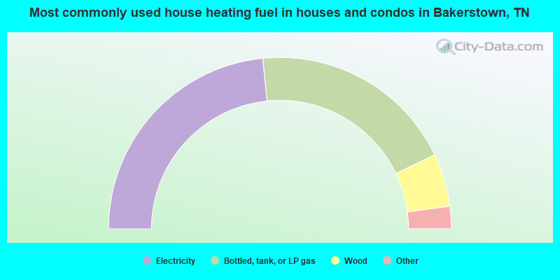
- 46.8%Electricity
- 39.0%Bottled, tank, or LP gas
- 10.0%Wood
- 3.2%Utility gas
- 1.1%Other fuel
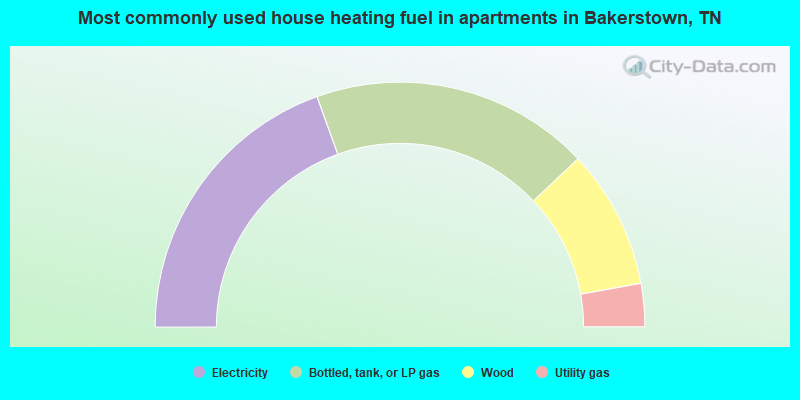
- 39.0%Electricity
- 36.9%Bottled, tank, or LP gas
- 18.4%Wood
- 5.7%Utility gas
Bakerstown compared to Tennessee state average:
- Unemployed percentage significantly below state average.
- Black race population percentage significantly below state average.
- Hispanic race population percentage significantly below state average.
- Foreign-born population percentage significantly below state average.
- Renting percentage significantly below state average.
- Length of stay since moving in significantly above state average.
- Number of rooms per house significantly below state average.
- House age significantly below state average.
- Percentage of population with a bachelor's degree or higher below state average.